
South Otago
Encyclopedia
South Otago lies in the south east of the South Island
of New Zealand
. As the name suggests, it forms the southernmost part of the geographical region of Otago
.
The exact definition of the area designated as South Otago is imprecise, as the area is not defined in geopolitical or administrative terms, but rather by the area's topographical features and the similarity of its communities. Overall, it encompasses some 8,000 km² (3,100 sq mi) and has a population of approximately 20,000, but these figures vary according to the various definitions of South Otago's boundaries. The area is often seen as roughly congruous with the Clutha District
, which has its administrative centre at Balclutha
. Most definitions of South Otago extend northeast from Clutha District, however, including rural parts of Dunedin
city, including coastal townships such as Brighton
and small settlements on the Taieri Plains
such as Outram
. Some definitions of South Otago include the large township of Mosgiel
- technically a major suburb of Dunedin.
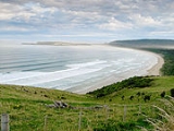
 South Otago is dominated by three main topographic features. To the south is the rough bush country of the Catlins
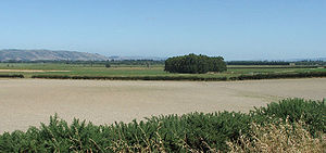
, with its forests and rugged coastline. To the north of that the land is mainly rolling hill country, bisected by the floodplain
s of several large rivers. With the exception of this flat, fertile area, South Otago is quite sparsely populated due to relatively cold winters, geographical isolation and lack of a decent port.
There are a number of rivers flowing through South Otago, the largest of them is the Clutha
, the country's second longest river, which flows from Lake Wanaka
in Central Otago
for 340 kilometres, through Balclutha (Scots Gaelic for "Town on the banks of the Clutha (Clyde)") and there splits in two around the river delta known as Inch Clutha before reaching the Pacific Ocean
.
Also of note is the Taieri
, the country's fourth longest river, which winds through rough hill country before forming the Taieri Plains
to the north of Milton. Lakes Waihola
and Waipori
, which ultimately drain into the Taieri through its tributary the Waipori River
, are also located in South Otago. Between and roughly parallel with these two large rivers is the smaller Tokomairiro River
.
 if the occasional inclusion of Mosgiel
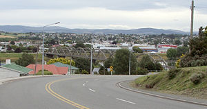
in definitions of South Otago is discounted, the most populous town in South Otago is Balclutha
, which lies 81 km south of Dunedin
by road. Balclutha's population, by the 2006 census, was 4,062 (down from 4,137 in 1996). Other towns are Milton
(pop. 1,887), Kaitangata
(pop. 810), Tapanui
(pop. 744), Brighton
, Lawrence
(pop. 432), Owaka
(pop. 327), Stirling (pop. 309), Waihola, Outram
, Allanton, Henley
, Clinton
(pop. 291), Momona
, Kaka Point
(pop. 201), Taieri Mouth
, and Benhar
(pop. 96). For a while in the 1980s Balclutha was New Zealand's most wealthy town, per capita.
Residents of South Otago and Southland have a prominent accent which is noticeably different from that of the rest of New Zealand, with a rolling 'r' that is almost certainly an indication of the Gaelic roots of many of the residents. This is also indicated in the Scots Gaelic and Lallans Scots
origins of many of the area's placenames. The people are paradoxically warm and friendly yet wary of strangers in their midst. Whilst remaining relatively crime free, the influence of a cynical outside world has had a noticeable influence on the people of South Otago in the past several years.
and predominantly Scottish
settlers, the latter of whom arrived in the 1840s and 1850s. As happened in most of the South Island, the land was bought by these settlers for minuscule sums, from its original Māori inhabitants. Later, the main Māori tribe from the area, Kai Tahu
, received a large cash settlement from the New Zealand Government as reparation for the confiscation of land that took place during that colonisation period.
 The Central Otago Gold Rush
of the 1860s, initially centred around Lawrence
, drew thousands of men to the district in search of wealth. The discovery of coal at Kaitangata
was also important for the regions development, and was also responsible for the region's worst disaster, an explosion at the mine in 1879.
In more recent times the region has been associated with wool
len milling and forestry
. Sheep, dairy
cattle and deer
are farmed locally, and farming and farm-related industries are the mainstay of the region's economy. Tourism
, particularly around the Catlins
, is also becoming important to the region.
South Otago's close association with Dunedin has increased since the reorganisation of local government areas in the 1980s. The northern part of South Otago, including much of the Taieri Plains, is now within the boundaries of Dunedin City (the rest of the area is almost entirely within Clutha District). The location of Dunedin International Airport
at Momona
is the area's most important transport hub, though most of the people who use this travel only briefly through South Otago while commuting to and from Dunedin. South Otago is also home to Lake Mahinerangi
, Dunedin's most important reservoir, which is located close to the top of Maungatua
.
South Island
The South Island is the larger of the two major islands of New Zealand, the other being the more populous North Island. It is bordered to the north by Cook Strait, to the west by the Tasman Sea, to the south and east by the Pacific Ocean...
of New Zealand
New Zealand
New Zealand is an island country in the south-western Pacific Ocean comprising two main landmasses and numerous smaller islands. The country is situated some east of Australia across the Tasman Sea, and roughly south of the Pacific island nations of New Caledonia, Fiji, and Tonga...
. As the name suggests, it forms the southernmost part of the geographical region of Otago
Otago
Otago is a region of New Zealand in the south of the South Island. The region covers an area of approximately making it the country's second largest region. The population of Otago is...
.
The exact definition of the area designated as South Otago is imprecise, as the area is not defined in geopolitical or administrative terms, but rather by the area's topographical features and the similarity of its communities. Overall, it encompasses some 8,000 km² (3,100 sq mi) and has a population of approximately 20,000, but these figures vary according to the various definitions of South Otago's boundaries. The area is often seen as roughly congruous with the Clutha District
Clutha District
The Clutha District is an administrative district of southern New Zealand, with its headquarters in the Otago town of Balclutha. The Clutha District has a land area of 6,362.86 km² and a 2006 census population of 16,839 usual residents...
, which has its administrative centre at Balclutha
Balclutha, New Zealand
Balclutha is a town in Otago, it lies towards the end of the Clutha River on the east coast of the South Island of New Zealand. It is about halfway between Dunedin and Invercargill on the Main South Line railway, State Highway 1 and the Southern Scenic Route...
. Most definitions of South Otago extend northeast from Clutha District, however, including rural parts of Dunedin
Dunedin
Dunedin is the second-largest city in the South Island of New Zealand, and the principal city of the Otago Region. It is considered to be one of the four main urban centres of New Zealand for historic, cultural, and geographic reasons. Dunedin was the largest city by territorial land area until...
city, including coastal townships such as Brighton
Brighton, New Zealand
"Ocean View, New Zealand" redirects here. For the inner Dunedin suburb occasionally referred to as Ocean View, see Andersons BayBrighton is a small seaside town within the city limits of Dunedin, in New Zealand's South Island. It is located 20 kilometres southwest from the city centre on the...
and small settlements on the Taieri Plains
Taieri Plains
The Taieri Plains are an area of fertile agricultural land to the southwest of Dunedin, in Otago, New Zealand. The plains cover an area of some 300 square kilometres, with a maximum extent of 30 kilometres....
such as Outram
Outram, New Zealand
Outram is a rural suburb of Dunedin, New Zealand, with a population of 642 . It is located 28 kilometres west of the central city at the edge of the Taieri Plains, close to the foot of Maungatua. The Taieri River flows close to the southeast of the town...
. Some definitions of South Otago include the large township of Mosgiel
Mosgiel
Mosgiel is an urban satellite of Dunedin in Otago, New Zealand, fifteen kilometres west of the city's centre. Since the re-organisation of New Zealand local government in 1989 it has been inside the Dunedin City Council area, but was physically separate from the contiguous suburbs until...
- technically a major suburb of Dunedin.
Geography
The Catlins
The Catlins comprises an area in the southeastern corner of the South Island of New Zealand. The area lies between Balclutha and Invercargill, straddling the boundary between the Otago and Southland regions...
, with its forests and rugged coastline. To the north of that the land is mainly rolling hill country, bisected by the floodplain
Floodplain
A floodplain, or flood plain, is a flat or nearly flat land adjacent a stream or river that stretches from the banks of its channel to the base of the enclosing valley walls and experiences flooding during periods of high discharge...
s of several large rivers. With the exception of this flat, fertile area, South Otago is quite sparsely populated due to relatively cold winters, geographical isolation and lack of a decent port.
There are a number of rivers flowing through South Otago, the largest of them is the Clutha
Clutha River
The Clutha River / Mata-Au is the second longest river in New Zealand flowing south-southeast through Central and South Otago from Lake Wanaka in the Southern Alps to the Pacific Ocean, south west of Dunedin. It is the highest volume river in New Zealand, and the swiftest, with a catchment of ,...
, the country's second longest river, which flows from Lake Wanaka
Lake Wanaka
Lake Wanaka is located in the Otago region of New Zealand, at an altitude of 300 metres. Covering an area of , it is New Zealand's fourth largest lake, and estimated to be more than deep...
in Central Otago
Central Otago
Central Otago is the inland part of the New Zealand region of Otago in the South Island. The area commonly known as Central Otago includes both the Central Otago District and the Queenstown-Lakes District to the west....
for 340 kilometres, through Balclutha (Scots Gaelic for "Town on the banks of the Clutha (Clyde)") and there splits in two around the river delta known as Inch Clutha before reaching the Pacific Ocean
Pacific Ocean
The Pacific Ocean is the largest of the Earth's oceanic divisions. It extends from the Arctic in the north to the Southern Ocean in the south, bounded by Asia and Australia in the west, and the Americas in the east.At 165.2 million square kilometres in area, this largest division of the World...
.
Also of note is the Taieri
Taieri River
The Taieri River is the fourth-longest river in New Zealand and is located in Otago in the South Island. Rising in the Lammerlaw ranges, it initially flows north, then east around the Rock and Pillar range before turning southeast, reaching the sea 30 km south of Dunedin.The upper reaches meander...
, the country's fourth longest river, which winds through rough hill country before forming the Taieri Plains
Taieri Plains
The Taieri Plains are an area of fertile agricultural land to the southwest of Dunedin, in Otago, New Zealand. The plains cover an area of some 300 square kilometres, with a maximum extent of 30 kilometres....
to the north of Milton. Lakes Waihola
Lake Waihola
Lake Waihola is a tidal freshwater lake located 15 km north of Milton in Otago, in New Zealand's South Island. Its area is some 9 square kilometres, with a maximum length of 6 kilometres....
and Waipori
Lake Waipori
Lake Waipori is the smaller and shallower of the pair of lakes located in the wetlands to the south west of Dunedin in New Zealand on the Waipori River. The Waipori River is a major tributary of the Taieri River, and these wetlands form the southern edge of the Taieri Plains.The lake is inhabited...
, which ultimately drain into the Taieri through its tributary the Waipori River
Waipori River
The Waipori River is located in Otago in the South Island of New Zealand. Rising in the Lammerlaw Range, it flows southeast for 50 kilometres before joining the Taieri River near Henley, 30 km southwest of Dunedin of which it is officially the southernmost border.The upper reaches of the Waipori...
, are also located in South Otago. Between and roughly parallel with these two large rivers is the smaller Tokomairiro River
Tokomairiro River
The Tokomairiro River is located in Otago, New Zealand. It flows southeast for some 50 kilometres , reaching the Pacific Ocean at Toko Mouth 50 kilometres south of Dunedin...
.
People
Mosgiel
Mosgiel is an urban satellite of Dunedin in Otago, New Zealand, fifteen kilometres west of the city's centre. Since the re-organisation of New Zealand local government in 1989 it has been inside the Dunedin City Council area, but was physically separate from the contiguous suburbs until...
in definitions of South Otago is discounted, the most populous town in South Otago is Balclutha
Balclutha, New Zealand
Balclutha is a town in Otago, it lies towards the end of the Clutha River on the east coast of the South Island of New Zealand. It is about halfway between Dunedin and Invercargill on the Main South Line railway, State Highway 1 and the Southern Scenic Route...
, which lies 81 km south of Dunedin
Dunedin
Dunedin is the second-largest city in the South Island of New Zealand, and the principal city of the Otago Region. It is considered to be one of the four main urban centres of New Zealand for historic, cultural, and geographic reasons. Dunedin was the largest city by territorial land area until...
by road. Balclutha's population, by the 2006 census, was 4,062 (down from 4,137 in 1996). Other towns are Milton
Milton, New Zealand
Milton is a town of 2,000 people, located on State Highway 1, 50 kilometres to the south of Dunedin in Otago, New Zealand. It lies on the floodplain of the Tokomairiro River, one branch of which loops past the north and south ends of the town...
(pop. 1,887), Kaitangata
Kaitangata, New Zealand
Kaitangata is a town near the coast of South Otago, New Zealand, on the left bank of the Clutha River ten kilometres south east of Balclutha. The town is known to its residents simply as Kai....
(pop. 810), Tapanui
Tapanui
Tapanui is a picturesque town in West Otago in New Zealand's South Island, close to the boundary with Southland region . A forestry town, it lies between the foot of the Blue Mountains and the Pomahaka River. Deer stalking and trout fishing are popular pastimes of the area...
(pop. 744), Brighton
Brighton, New Zealand
"Ocean View, New Zealand" redirects here. For the inner Dunedin suburb occasionally referred to as Ocean View, see Andersons BayBrighton is a small seaside town within the city limits of Dunedin, in New Zealand's South Island. It is located 20 kilometres southwest from the city centre on the...
, Lawrence
Lawrence, New Zealand
Lawrence is a small town of 474 inhabitants in Otago, in New Zealand's South Island. It is located on State Highway 8, the main route from Dunedin to the inland towns of Queenstown and Alexandra...
(pop. 432), Owaka
Owaka
Owaka is a small town in Otago, in the southern South Island of New Zealand. It is the largest community in the rugged, forested Catlins area, close to the border with Southland, some south of Balclutha on the Southern Scenic Route. The town's population was 334 in the 2006 census, a decrease of...
(pop. 327), Stirling (pop. 309), Waihola, Outram
Outram, New Zealand
Outram is a rural suburb of Dunedin, New Zealand, with a population of 642 . It is located 28 kilometres west of the central city at the edge of the Taieri Plains, close to the foot of Maungatua. The Taieri River flows close to the southeast of the town...
, Allanton, Henley
Henley, New Zealand
Henley is a township on New Zealand's Taieri Plains, presumably named after the rowing centre Henley-on-Thames in England. It lies close to the confluence of the Taieri and Waipori Rivers at the eastern edge of the plain, at the foot of a low range of coastal hills.Henley is near the south-west...
, Clinton
Clinton, New Zealand
Clinton is a small town in South Otago, in New Zealand's South Island. It is located on State Highway 1 approximately half way between Balclutha and Gore , and the Main South Line railway passes through the town.Clinton was named for Henry Pelham-Clinton, 5th...
(pop. 291), Momona
Momona
Momona is a small town in New Zealand's South Island. It is located in the centre of the fertile floodplain of the Taieri River ....
, Kaka Point
Kaka Point
Kaka Point is a small settlement at the northern edge of The Catlins, an area of the southern South Island of New Zealand. It is located 14 kilometres south of Balclutha and eight kilometres north of the headland of Nugget Point. It has a seasonally fluctuating population, and there are numerous...
(pop. 201), Taieri Mouth
Taieri Mouth
Taieri Mouth is a small fishing village at the mouth of the Taieri River, New Zealand. Taieri Island lies in the ocean several hundred metres off the river's mouth.It has a white sand beach for swimming and several picnic areas...
, and Benhar
Benhar, New Zealand
Benhar is a settlement in New Zealand....
(pop. 96). For a while in the 1980s Balclutha was New Zealand's most wealthy town, per capita.
Residents of South Otago and Southland have a prominent accent which is noticeably different from that of the rest of New Zealand, with a rolling 'r' that is almost certainly an indication of the Gaelic roots of many of the residents. This is also indicated in the Scots Gaelic and Lallans Scots
Scots language
Scots is the Germanic language variety spoken in Lowland Scotland and parts of Ulster . It is sometimes called Lowland Scots to distinguish it from Scottish Gaelic, the Celtic language variety spoken in most of the western Highlands and in the Hebrides.Since there are no universally accepted...
origins of many of the area's placenames. The people are paradoxically warm and friendly yet wary of strangers in their midst. Whilst remaining relatively crime free, the influence of a cynical outside world has had a noticeable influence on the people of South Otago in the past several years.
Notable residents
- Ken BloxhamKen BloxhamKenneth Charles Bloxham was a New Zealand rugby union footballer.-Career:Born and educated in Milton, Bloxham represented the local Tokomairiro club, and won a place in the Otago provincial side from 1974–1981, playing as hooker.He briefly represented New Zealand, playing in two All Blacks matches...
(rugby player) - Tony BrownTony Brown (rugby player)Tony Eion Brown is a New Zealand rugby union footballer, playing mainly at first five-eighth .-Early life:...
(rugby player) - Frank Oliver (rugby player)
- Daryl TuffeyDaryl TuffeyDaryl Raymond Tuffey is a New Zealand cricketer who has represented New Zealand at Test and ODI level, and plays domestic first class cricket for Northern Districts Knights. He is playfully known as Daryl "Huffy-Puffy" Tuffey by his Northern Districts team mates due to his heavy breathing when...
(cricketer) - Hone TuwhareHone TuwhareHone Tuwhare was a noted New Zealand poet of Māori ancestry. He is closely associated with The Catlins in the Otago region of New Zealand, where he lived for the latter part of his life.-Early years:...
(poet) - John Joseph WoodsJohn Joseph WoodsJohn Joseph Woods was a New Zealand teacher and songwriter. He is best known for winning a competition to set "God Defend New Zealand", a poem by Thomas Bracken, to music. By doing this, he composed the tune to what later became New Zealand's national anthem...
(writer of the music of New Zealand's national anthem, God Defend New Zealand)
History
The area has a rich history, with Māori iwiIwi
In New Zealand society, iwi form the largest everyday social units in Māori culture. The word iwi means "'peoples' or 'nations'. In "the work of European writers which treat iwi and hapū as parts of a hierarchical structure", it has been used to mean "tribe" , or confederation of tribes,...
and predominantly Scottish
Scotland
Scotland is a country that is part of the United Kingdom. Occupying the northern third of the island of Great Britain, it shares a border with England to the south and is bounded by the North Sea to the east, the Atlantic Ocean to the north and west, and the North Channel and Irish Sea to the...
settlers, the latter of whom arrived in the 1840s and 1850s. As happened in most of the South Island, the land was bought by these settlers for minuscule sums, from its original Māori inhabitants. Later, the main Māori tribe from the area, Kai Tahu
Ngai Tahu
Ngāi Tahu, or Kāi Tahu, is the principal Māori iwi of the southern region of New Zealand, with the tribal authority, Te Rūnanga o Ngāi Tahu, being based in Christchurch and Invercargill. The iwi combines three groups, Kāi Tahu itself, and Waitaha and Kāti Mamoe who lived in the South Island prior...
, received a large cash settlement from the New Zealand Government as reparation for the confiscation of land that took place during that colonisation period.
Central Otago Gold Rush
The Central Otago Gold Rush was a gold rush that occurred during the 1860s in Central Otago, New Zealand...
of the 1860s, initially centred around Lawrence
Lawrence, New Zealand
Lawrence is a small town of 474 inhabitants in Otago, in New Zealand's South Island. It is located on State Highway 8, the main route from Dunedin to the inland towns of Queenstown and Alexandra...
, drew thousands of men to the district in search of wealth. The discovery of coal at Kaitangata
Kaitangata, New Zealand
Kaitangata is a town near the coast of South Otago, New Zealand, on the left bank of the Clutha River ten kilometres south east of Balclutha. The town is known to its residents simply as Kai....
was also important for the regions development, and was also responsible for the region's worst disaster, an explosion at the mine in 1879.
In more recent times the region has been associated with wool
Wool
Wool is the textile fiber obtained from sheep and certain other animals, including cashmere from goats, mohair from goats, qiviut from muskoxen, vicuña, alpaca, camel from animals in the camel family, and angora from rabbits....
len milling and forestry
Forestry
Forestry is the interdisciplinary profession embracing the science, art, and craft of creating, managing, using, and conserving forests and associated resources in a sustainable manner to meet desired goals, needs, and values for human benefit. Forestry is practiced in plantations and natural stands...
. Sheep, dairy
Dairy
A dairy is a business enterprise established for the harvesting of animal milk—mostly from cows or goats, but also from buffalo, sheep, horses or camels —for human consumption. A dairy is typically located on a dedicated dairy farm or section of a multi-purpose farm that is concerned...
cattle and deer
Deer
Deer are the ruminant mammals forming the family Cervidae. Species in the Cervidae family include white-tailed deer, elk, moose, red deer, reindeer, fallow deer, roe deer and chital. Male deer of all species and female reindeer grow and shed new antlers each year...
are farmed locally, and farming and farm-related industries are the mainstay of the region's economy. Tourism
Tourism
Tourism is travel for recreational, leisure or business purposes. The World Tourism Organization defines tourists as people "traveling to and staying in places outside their usual environment for not more than one consecutive year for leisure, business and other purposes".Tourism has become a...
, particularly around the Catlins
The Catlins
The Catlins comprises an area in the southeastern corner of the South Island of New Zealand. The area lies between Balclutha and Invercargill, straddling the boundary between the Otago and Southland regions...
, is also becoming important to the region.
South Otago's close association with Dunedin has increased since the reorganisation of local government areas in the 1980s. The northern part of South Otago, including much of the Taieri Plains, is now within the boundaries of Dunedin City (the rest of the area is almost entirely within Clutha District). The location of Dunedin International Airport
Dunedin International Airport
Dunedin International Airport is an international airport in the Otago region of the South Island of New Zealand, serving Dunedin city and the Otago and Southland regions. Dunedin International Airport is one of two international airports in Otago, the other being Queenstown International Airport...
at Momona
Momona
Momona is a small town in New Zealand's South Island. It is located in the centre of the fertile floodplain of the Taieri River ....
is the area's most important transport hub, though most of the people who use this travel only briefly through South Otago while commuting to and from Dunedin. South Otago is also home to Lake Mahinerangi
Lake Mahinerangi
Lake Mahinerangi is a small hydroelectric lake formed by a dam on the Waipori River 35 kilometres to the west of Dunedin in New Zealand's South Island....
, Dunedin's most important reservoir, which is located close to the top of Maungatua
Maungatua
Often incorrectly called The Maungatuas or The Maungatua Range, Maungatua is a prominent ridge which dominates the skyline of the Taieri Plains in Otago, New Zealand...
.