

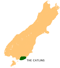
The Catlins
Encyclopedia
 |
|
| Location | |
|---|---|
| Country: | New Zealand |
| Island: | South Island South Island The South Island is the larger of the two major islands of New Zealand, the other being the more populous North Island. It is bordered to the north by Cook Strait, to the west by the Tasman Sea, to the south and east by the Pacific Ocean... |
| Statistics | |
| Population Population A population is all the organisms that both belong to the same group or species and live in the same geographical area. The area that is used to define a sexual population is such that inter-breeding is possible between any pair within the area and more probable than cross-breeding with individuals... : |
approximately 1,200 (2001) |
| Area Area Area is a quantity that expresses the extent of a two-dimensional surface or shape in the plane. Area can be understood as the amount of material with a given thickness that would be necessary to fashion a model of the shape, or the amount of paint necessary to cover the surface with a single coat... : |
1900 sqkm |
| Location | |
| Coordinates: | 46°30′S 169°30′E |
| Administration | |
| Regions Regions of New Zealand The region is the top tier of local government in New Zealand. There are 16 regions of New Zealand. Eleven are governed by an elected regional council, while five are governed by territorial authorities which also perform the functions of a regional council and thus are known as unitary authorities... : |
Otago Otago Otago is a region of New Zealand in the south of the South Island. The region covers an area of approximately making it the country's second largest region. The population of Otago is... and Southland Southland Region Southland is New Zealand's southernmost region and is also a district within that region. It consists mainly of the southwestern portion of the South Island and Stewart Island / Rakiura... |
| District Territorial authorities of New Zealand Territorial authorities are the second tier of local government in New Zealand, below regional councils. There are 67 territorial authorities: 13 city councils, 53 district councils, and the Chatham Islands Council... s: |
Clutha District Clutha District The Clutha District is an administrative district of southern New Zealand, with its headquarters in the Otago town of Balclutha. The Clutha District has a land area of 6,362.86 km² and a 2006 census population of 16,839 usual residents... and Southland District Southland District Southland District is a territorial authority in the South Island of New Zealand. Southland District covers the majority of the land area of Southland Region, although the region also covers Gore District, Invercargill City and adjacent territorial waters... |
| Main towns and settlements: | Owaka Owaka Owaka is a small town in Otago, in the southern South Island of New Zealand. It is the largest community in the rugged, forested Catlins area, close to the border with Southland, some south of Balclutha on the Southern Scenic Route. The town's population was 334 in the 2006 census, a decrease of... , Waikawa Waikawa, Southland Waikawa is the name of a small settlement in Southland, New Zealand, at the southwestern edge of The Catlins.The township is now a small fishing settlement, but at one time in the late 19th century was a major port, shipping timber from the sawmills of the Catlins north to help build the new town... , Tokanui Tokanui Tokanui is a community in the eastern portion of Southland District Council, located on the Southern Scenic Route about 55 km east of Invercargill and 109 km southwest of Balclutha, New Zealand.... , Kaka Point Kaka Point Kaka Point is a small settlement at the northern edge of The Catlins, an area of the southern South Island of New Zealand. It is located 14 kilometres south of Balclutha and eight kilometres north of the headland of Nugget Point. It has a seasonally fluctuating population, and there are numerous... , Fortrose Fortrose, New Zealand Fortrose is a locality on the southernmost coast of the South Island of New Zealand in the Southland region. It is situated on Toetoes Bay at the mouth of the Mataura River, and is on the far western edge of the Catlins... |
| Parliamentary electorate New Zealand electorates An electorate is a voting district for elections to the Parliament of New Zealand. In informal discussion, electorates are often called seats. The most formal description, electoral district, is rarely seen outside of electoral legislation. Before 1996, all Members of Parliament were directly... : |
Clutha-Southland |
 |
|
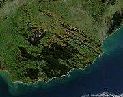
The Catlins (sometimes referred to as The Catlins Coast) comprises an area in the southeastern corner of the South Island
South Island
The South Island is the larger of the two major islands of New Zealand, the other being the more populous North Island. It is bordered to the north by Cook Strait, to the west by the Tasman Sea, to the south and east by the Pacific Ocean...
of New Zealand. The area lies between Balclutha
Balclutha, New Zealand
Balclutha is a town in Otago, it lies towards the end of the Clutha River on the east coast of the South Island of New Zealand. It is about halfway between Dunedin and Invercargill on the Main South Line railway, State Highway 1 and the Southern Scenic Route...
and Invercargill
Invercargill
Invercargill is the southernmost and westernmost city in New Zealand, and one of the southernmost cities in the world. It is the commercial centre of the Southland region. It lies in the heart of the wide expanse of the Southland Plains on the Oreti or New River some 18 km north of Bluff,...
, straddling the boundary between the Otago
Otago
Otago is a region of New Zealand in the south of the South Island. The region covers an area of approximately making it the country's second largest region. The population of Otago is...
and Southland
Southland Region
Southland is New Zealand's southernmost region and is also a district within that region. It consists mainly of the southwestern portion of the South Island and Stewart Island / Rakiura...
regions. It includes the South Island's southernmost point, Slope Point
Slope Point
Slope Point is the southernmost point of the South Island of New Zealand.Slope Point lies just south of the small settlements of Waikawa and Haldane, near the southwestern edge of the Catlins and Toetoes Bay and 70 km east of Invercargill....
.
A rugged, sparsely populated area, the Catlins features a scenic coastal landscape and dense temperate rainforest
Temperate rain forest
Temperate rainforests are coniferous or broadleaf forests that occur in the temperate zone and receive high rainfall.-Definition:For temperate rain forests of North America, Alaback's definition is widely recognized:-Global distribution:...
, both of which harbour many endangered species
Endangered species
An endangered species is a population of organisms which is at risk of becoming extinct because it is either few in numbers, or threatened by changing environmental or predation parameters...
of birds, most notably the rare yellow-eyed penguin
Yellow-eyed Penguin
The Yellow-eyed Penguin or Hoiho is a penguin native to New Zealand. Previously thought closely related to the Little Penguin , molecular research has shown it more closely related to penguins of the genus Eudyptes...
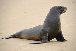
. The coast attracts numerous marine mammals, among them New Zealand fur seal
New Zealand Fur Seal
The Australian fur seal , or New Zealand fur seal or southern fur seal, is a species of fur seal found around the south coast of Australia, the coast of the South Island of New Zealand, and some of the small islands to the south and east of there...
s and Hooker's sea lions. In general terms the area enjoys a maritime temperate climate. Its exposed location leads to its frequently wild weather and heavy ocean swells, which are an attraction to big-wave surfers
Big wave surfing
Big wave surfing is a discipline within surfing in which experienced surfers paddle into or are towed onto waves which are at least 20 feet high, on surf boards known as "guns" or "rhino chasers". Sizes of the board needed to successfully surf these waves vary by the size of the wave as well as...
, and have also caused numerous shipwrecks.
People have lived in the area since around 1350 AD. Prior to European settlement, the region was sparsely inhabited by nomadic groups of Māori, most of whom lived close to river mouths. In the early days of European settlement the area was frequented by whalers and sealers, and saw milling became a major local industry from the mid-19th century until the 1930s. Ecotourism
Ecotourism
Ecotourism is a form of tourism visiting fragile, pristine, and usually protected areas, intended as a low impact and often small scale alternative to standard commercial tourism...
has become of growing importance in the Catlins economy, which otherwise relies heavily on dairy farming and fishing.
The region's population has fallen to less than half its peak in the early 20th century. Some 1,200 people now live in the Catlins, many of them in the settlement of Owaka
Owaka
Owaka is a small town in Otago, in the southern South Island of New Zealand. It is the largest community in the rugged, forested Catlins area, close to the border with Southland, some south of Balclutha on the Southern Scenic Route. The town's population was 334 in the 2006 census, a decrease of...
. This is linked to population centres to the north and southwest via the area's only major road, part of the Southern Scenic Route
Southern Scenic Route
The Southern Scenic Route is a tourist highway in New Zealand linking Queenstown, Fiordland, Te Anau and the iconic Milford Road to Dunedin via, Riverton, Invercargill and The Catlins...
. Owaka contains the area's main school, one of only four small schools in the Catlins; secondary and tertiary students travel to neighbouring centres for their education. It also has a medical centre, the nearest hospital being in Balclutha. The Catlins are governed at local level as part of the Clutha
Clutha District
The Clutha District is an administrative district of southern New Zealand, with its headquarters in the Otago town of Balclutha. The Clutha District has a land area of 6,362.86 km² and a 2006 census population of 16,839 usual residents...
and Southland District
Southland District
Southland District is a territorial authority in the South Island of New Zealand. Southland District covers the majority of the land area of Southland Region, although the region also covers Gore District, Invercargill City and adjacent territorial waters...
s and are represented at national level as part of the Clutha-Southland electorate.
Geography
Clutha River
The Clutha River / Mata-Au is the second longest river in New Zealand flowing south-southeast through Central and South Otago from Lake Wanaka in the Southern Alps to the Pacific Ocean, south west of Dunedin. It is the highest volume river in New Zealand, and the swiftest, with a catchment of ,...
in the northeast and the Mataura River
Mataura River
The Mataura River is in the Southland Region of the South Island of New Zealand. It is 190 kilometres in length.The river's headwaters are located in mountains to the south of Lake Wakatipu. From there it flows southeast towards Gore, where it turns southward...
in the west, mark its coastal limits. To the north and northwest, the rough bush
The Bush
"The bush" is a term used for rural, undeveloped land or country areas in certain countries.-Australia:The term is iconic in Australia. In reference to the landscape, "bush" describes a wooded area, intermediate between a shrubland and a forest, generally of dry and nitrogen-poor soil, mostly...
-clad hills give way to rolling pastoral countryside drained and softened by the actions of tributaries of these two rivers such as the Pomahaka River
Pomahaka River
The Pomahaka River is located in South Otago in New Zealand's South Island. It is a tributary of the Clutha River, flowing south for 80 kilometres from the Old Man Range of mountains to join the Clutha just north of Balclutha...
.
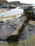
The rugged, scenic coastline of the Catlins features sandy beaches, blowhole
Blowhole (geology)
In geology, a blowhole is formed as sea caves grow landwards and upwards into vertical shafts and expose themselves towards the surface, which can result in blasts of water from the top of the blowhole if the geometry of the cave and blowhole and state of the weather are appropriate.A blowhole is...
s, a petrified forest
Petrified wood
Petrified wood is the name given to a special type of fossilized remains of terrestrial vegetation. It is the result of a tree having turned completely into stone by the process of permineralization...
at Curio Bay
Curio Bay
Located near the southern end of New Zealand's South Island, Curio Bay is a coastal embayment best known as the site of a petrified forest some 180 million years old. It also hosts a yellow-eyed penguin colony, arguably the rarest of penguin species, with approximately 1600 breeding pairs in the...
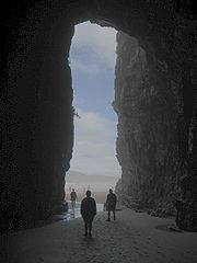
, and the Cathedral Caves
Cathedral Caves
The Cathedral Caves are a series of sea caves on the Catlins Coast in New Zealand. They are one of the most popular tourist attractions in the area. The two main caves join together within the cliff, and one has a 30 m high ceiling....
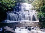
, which visitors can reach at low tide. Much of the coastline consists of high cliffs, up to 200 m (656.2 ft) in height, and the land rises sharply from the coast at most points. For this reason, many of the area's rivers cascade over waterfalls as they approach the ocean (notably the iconic Purakaunui Falls
Purakaunui Falls
The Purakaunui Falls are a cascading multi-tiered waterfall on the Purakaunui River, located in the Catlins in the southern South Island of New Zealand...
on the short Purakaunui River).
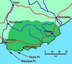
The South Island's southernmost point, Slope Point
Slope Point
Slope Point is the southernmost point of the South Island of New Zealand.Slope Point lies just south of the small settlements of Waikawa and Haldane, near the southwestern edge of the Catlins and Toetoes Bay and 70 km east of Invercargill....
, projects near the southwestern corner of the Catlins. To the west of this lies Waipapa Point
Waipapa Point
Waipapa Point is a rocky promontory on the south coast of the South Island of New Zealand. It is located southeast of the mouth of the Mataura River, at the extreme southwestern end of the area known as the Catlins....
, often considered the boundary of the Catlins region, beyond which lies the swampy land around the mouth of the Mataura River at the eastern end of Toetoes Bay
Toetoes Bay
Toetoes Bay is the easternmost of three large bays lying on the Foveaux Strait coast of Southland, New Zealand, the others being Te Waewae Bay and Oreti Beach. Thirty kilometres in length, the bay is the southern end of the Awarua Plain, an area of swampy land stretching inland for about fifteen...
. But various people place the western boundary of the Catlins region in different places, and some more stringent definitions exclude even Slope Point. A proposed boundary circulated in 2009 by the New Zealand Geographic Board
New Zealand Geographic Board
The New Zealand Geographic Board is constituted under the New Zealand Geographic Board Act 2008, formerly under the New Zealand Geographic Board Act 1946. Although an independent institution, it is responsible to the Minister for Land Information...
ran roughly north from Slope Point, then inland around the Catlins Ranges and east to Nugget Point. Tourist organisations objected, asking that the boundary be moved further west to include Fortrose
Fortrose, New Zealand
Fortrose is a locality on the southernmost coast of the South Island of New Zealand in the Southland region. It is situated on Toetoes Bay at the mouth of the Mataura River, and is on the far western edge of the Catlins...
.
Owaka River
The ' flows southeastward through The Catlins, an area of the southern South Island of New Zealand. Its total length is , and it shares the estuary of the Catlins River, flowing into the Pacific Ocean at Pounawea, south of Balclutha. Its source is on the slopes of Mt Rosebery, south of...
, Catlins
Catlins River
The ' flows southeastward through The Catlins, an area of the southern South Island of New Zealand. Its total length is , and it shares its estuary with the Owaka River, flowing into the Pacific Ocean at Pounawea, south of Balclutha....
and Tahakopa River
Tahakopa River
The Tahakopa River flows southeastward through the Catlins, an area of the southern South Island of New Zealand. Its total length is , and it flows into the Pacific Ocean east of Waikawa, close to the settlement of Papatowai....
s, which all drain southeastwards into the Pacific Ocean. The most notable of these ranges is the Maclennan Range. Between them, these hills are often simply referred to as the Catlins Ranges
Catlins Ranges
The Catlins Ranges are a series of rugged, roughly parallel hill ranges in the southeastern corner of New Zealand's South Island. They take their name from the name given to this part of the country - the Catlins...
. Their northwestern slopes are drained by several tributaries of the Clutha and Mataura Rivers, most notably the Mokoreta River
Mokoreta River
The Mokoreta River is a river in Southland, New Zealand. A tributary of the Mataura River, its source is between Mt Rosebery and Catlins Cone, close to the source of the Catlins River. It flows westward from the Catlins Ranges into the Southland Plains.Its total length is 50 kilometres, and it...
, which flows mainly westwards, reaching the Mataura close to the town of Wyndham
Wyndham, New Zealand
Wyndham is a rural town of 550 people in the South Island of New Zealand in the Southland region, 45 km east of Invercargill and 25 km south of Gore. The original Māori name of the locality was Mokoreta .Wyndham was named for General Sir Charles Ashe Windham who fought in the Crimean War...
.
The highest point in the Catlins, Mount Pye
Mount Pye, New Zealand
Mount Pye is a rugged hill in the southeast of the South Island of New Zealand. It is the highest point in the area known as the Catlins, rising to 720 m . It is located 40 km southeast of Gore, and forms part of the border between the Otago and Southland regions. The headwaters of many...
(720 m or 2,362.2 ft) stands 25 km (15.5 mi) north-northeast of Waikawa
Waikawa, Southland
Waikawa is the name of a small settlement in Southland, New Zealand, at the southwestern edge of The Catlins.The township is now a small fishing settlement, but at one time in the late 19th century was a major port, shipping timber from the sawmills of the Catlins north to help build the new town...
and close to the source of the Mokoreta River, and marks part of the Otago-Southland border. Other prominent peaks above 600 m (1,968.5 ft) include Mount Rosebery, Catlins Cone, Mount Tautuku, and Ajax Hill. The Catlins has several small lakes, notably scenic Lake Wilkie
Lake Wilkie
Lake Wilkie is a small, scenic lake near Tautuku Bay in the Catlins, south of Dunedin, New Zealand. It formed behind sand dunes after the last ice age, and has gradually shrunk to its current size of 1.7 hectares . Bog lakes like Lake Wilkie are uncommon in this part of the country...
close to the Tautuku Peninsula
Tautuku Peninsula
The Tautuku Peninsula is a rocky headland on the south coast of Otago on the South Island of New Zealand. It is located 25 km east of Waikawa, at the western end of a bay in the area known as the Catlins...
. Catlins Lake, near Owaka, actually consists of the tidal estuary
Estuary
An estuary is a partly enclosed coastal body of water with one or more rivers or streams flowing into it, and with a free connection to the open sea....
of the Catlins River.
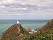
Shipping has found the Catlins coast notoriously dangerous, and many shipwrecks have occurred on the headlands that jut into the Pacific Ocean here. Two lighthouses stand at opposite ends of the Catlins to help prevent further mishaps. The Nugget Point Lighthouse
Nugget Point Lighthouse
Nugget Point Lighthouse is a lighthouse at Nugget Point in the Otago region of the South Island of New Zealand. It is owned and operated by Maritime New Zealand....
stands 76 m (249.3 ft) above the water at the end of Nugget Point
Nugget Point
Nugget Point is one of the most iconic landforms on the Otago coast. Located at the northern end of the Catlins coast down the road from Kaka Point, this steep headland has a lighthouse at its tip, surrounded by rocky islets...
, casting its light across a series of eroded stacks
Stack (geology)
A stack is a geological landform consisting of a steep and often vertical column or columns of rock in the sea near a coast, isolated by erosion. Stacks are formed through processes of coastal geomorphology, which are entirely natural. Time, wind and water are the only factors involved in the...
(the "nuggets" which give the point its name). It was built in 1869–70. The Waipapa Point light
Waipapa Point Lighthouse
Waipapa Point Lighthouse is a lighthouse located at Waipapa Point, Southland, New Zealand. It was first lit on January 1, 1884.The lighthouse was built in response to the wreck of the passenger steamer Tararua on reefs off Waipapa Point on April 29, 1881, with the loss of 131 lives...
, which stands only 21 m (68.9 ft) above sea level, was the last wooden lighthouse to be built in New Zealand, and was constructed in 1884 in response to the tragic 1881 wreck of the Tararua
SS Tararua
SS Tararua was a passenger steamer that struck the reef off Waipapa Point in the Catlins on 29 April 1881, and sank the next day, in the worst civilian shipping disaster in New Zealand's history. Of the 151 passengers and crew on board, only 20 survived the shipwreck.-Ship:The Tararua was a...
. Both of these lighthouses are now fully automated.
Due to its position at the southern tip of New Zealand, the Catlins coastline lies exposed to some of the country's largest ocean swell
Swell (ocean)
A swell, in the context of an ocean, sea or lake, is a series surface gravity waves that is not generated by the local wind. Swell waves often have a long wavelength but this varies with the size of the water body, e.g. rarely more than 150 m in the Mediterranean, and from event to event, with...
s, often over 5 m (16.4 ft). The region has enjoyed a growing reputation for big wave surfing
Big wave surfing
Big wave surfing is a discipline within surfing in which experienced surfers paddle into or are towed onto waves which are at least 20 feet high, on surf boards known as "guns" or "rhino chasers". Sizes of the board needed to successfully surf these waves vary by the size of the wave as well as...
, with regular competitions, award-winning rides, and coverage on the Discovery Channel
Discovery Channel
Discovery Channel is an American satellite and cable specialty channel , founded by John Hendricks and distributed by Discovery Communications. It is a publicly traded company run by CEO David Zaslav...
gathering publicity for the sport. The Department of Conservation proposed protecting the Papatowai
Papatowai
Papatowai is a small settlement in the Catlins district of the southeastern South Island of New Zealand. The settlement is situated half-way between the cities of Dunedin and Invercargill, on the Pacific coast close to the mouth of the Tahakopa River...
surf break in 2008, citing its national significance for surfing.
The landscape of the Catlins features in many poems by celebrated poet Hone Tuwhare
Hone Tuwhare
Hone Tuwhare was a noted New Zealand poet of Māori ancestry. He is closely associated with The Catlins in the Otago region of New Zealand, where he lived for the latter part of his life.-Early years:...
. Born in Northland, Tuwhare lived in Kaka Point from 1992 until his death in 2008, and became one of the area's best-known inhabitants. His family plan to establish a writers' retreat at his crib
Bach (New Zealand)
A bach is a small, often very modest holiday home or beach house. Alternatively called a crib, they are an iconic part of New Zealand history and culture, especially in the middle of the 20th century, where they symbolized the beach holiday lifestyle that was becoming more accessible to the...
there. The film Two Little Boys, starring comedians Bret McKenzie
Bret McKenzie
Bret Peter Tarrant McKenzie is a comedian, actor, musician and producer, best known for being one half of the Grammy Award winning musical comedy duo Flight of the Conchords along with Jemaine Clement....
and Hamish Blake
Hamish Blake
Hamish Donald Blake is an Australian comedian, actor, author and bodybuilder from Melbourne, Australia. Since 2003, he has worked with Andy Lee as part of the comedy duo Hamish and Andy. The pair have performed live and on television and radio, most notably with their drive-time radio program...
, was filmed in the Catlins early in 2011.
Climate
The Catlins has a cool maritimeOceanic climate
An oceanic climate, also called marine west coast climate, maritime climate, Cascadian climate and British climate for Köppen climate classification Cfb and subtropical highland for Köppen Cfb or Cwb, is a type of climate typically found along the west coasts at the middle latitudes of some of the...
temperate climate, somewhat cooler than other parts of the South Island, and strongly modified by the effect of the Pacific Ocean. Winds can reach considerable strength, especially on the exposed coast; most of the South Island's storms develop to the south or southwest of the island, and thus the Catlins catches the brunt of many of these weather patterns.
The Catlins—and especially its central and southern areas—experiences considerably higher precipitation than most of the South Island's east coast; heavy rain occurs infrequently, but drizzle is common and the region averages around 150 days of rain per year. Rain days are spread fairly evenly throughout the year; there is no particularly rainy season in the northern Catlins, and only a slight tendency towards more autumn rain in the southwest. The average annual rainfall recorded at the Tautuku Outdoor Education Centre is about 1300 mm (51.2 in), with little variation from year to year.
Fine days can be sunny and warm, and daily maxima may exceed 30 °C (86 °F) in mid-summer (January/February). A more usual daily maximum in summer would be 18 –. Snow is rare except on the peaks even in the coldest part of winter, though frost is quite common during the months of June to September. Typical daily maximum temperatures in winter are 10 –.
History
The first people known to live in the Catlins, Māori of the Kāti MamoeKati Mamoe
Kāti Mamoe, or Ngāti Mamoe, is an historic Māori iwi. Originally from the Heretaunga area they moved in the 16th century to the South Island which at the time was occupied by Waitaha....
, Waitaha
Waitaha
Waitaha is an early historical Māori iwi . Inhabitants of the South Island of New Zealand, they were largely absorbed via marriage and conquest first by the Kāti Mamoe and then Ngāi Tahu from the 16th century onward....
, and Kāi Tahu
Ngāi Tahu
Ngāi Tahu, or Kāi Tahu, is the principal Māori iwi of the southern region of New Zealand, with the tribal authority, Te Rūnanga o Ngāi Tahu, being based in Christchurch and Invercargill. The iwi combines three groups, Kāi Tahu itself, and Waitaha and Kāti Mamoe who lived in the South Island prior...
iwi
Iwi
In New Zealand society, iwi form the largest everyday social units in Māori culture. The word iwi means "'peoples' or 'nations'. In "the work of European writers which treat iwi and hapū as parts of a hierarchical structure", it has been used to mean "tribe" , or confederation of tribes,...
(tribes), merged via marriage and conquest into the iwi now known as Kāi Tahu. Archaeological evidence of human presence dates back to approximately 1350 AD. The area's inhabitants were semi-nomadic, travelling from Stewart Island/Rakiura
Stewart Island/Rakiura
Stewart Island/Rakiura is the third-largest island of New Zealand. It lies south of the South Island, across Foveaux Strait. Its permanent population is slightly over 400 people, most of whom live in the settlement of Oban.- History and naming :...
in the south and inland to Central Otago
Central Otago
Central Otago is the inland part of the New Zealand region of Otago in the South Island. The area commonly known as Central Otago includes both the Central Otago District and the Queenstown-Lakes District to the west....
. They generally dwelt near river mouths for easy access to the best food resources. In legend, the Catlins forests further inland were inhabited by Maeroero (wild giants).
The Catlins may have offered one of the last places where the giant flightless bird, the moa, could be hunted, and the timber of the forest proved ideal for canoe construction (the name of the settlement Owaka means "Place of the canoe"). No formal Māori pa
Pa (Maori)
The word pā can refer to any Māori village or settlement, but in traditional use it referred to hillforts fortified with palisades and defensive terraces and also to fortified villages. They first came into being about 1450. They are located mainly in the North Island north of lake Taupo...
(villages) were located in the Catlins, but there were many hunting camps, notably at Papatowai, near the mouth of the Tahakopa River.
Europeans first sighted the area in 1770 when the crew of James Cook
James Cook
Captain James Cook, FRS, RN was a British explorer, navigator and cartographer who ultimately rose to the rank of captain in the Royal Navy...
's Endeavour sailed along the coast. Cook named a bay in the Catlins area Molineux's Harbour after his ship's master Robert Molineux. Although this was almost certainly the mouth of the Waikawa River
Waikawa River
The Waikawa River flows east then south through the Catlins, an area of the southern South Island of New Zealand. Its total length is , and it flows into the Pacific Ocean at Waikawa. Close to its mouth, it cascades over a small series of cataracts, ironically named Niagara Falls.The river's source...
, later visitors applied the name to a bay to the northeast, close to the mouth of the Clutha River, which itself was for many years known as the Molyneux River.
Sealers and whalers founded the first European settlements in the early years of the 19th century, at which time the hunting of marine mammals dominated European economic activity in New Zealand. A whaling station was established on the Tautuku Peninsula in 1839, with smaller stations at Waikawa and close to the mouth of the Clutha River.
The Catlins take their name from the Catlins River, itself named for whaling captain Edward Cattlin (sometimes spelt Catlin). He purchased an extensive block of land along Catlins River on 15 February 1840 from Kāi Tahu chief Hone Tuhawaiki
Tuhawaiki
Tuhawaiki — often known as Hone Tuhawaiki, John Tuhawaiki or Jack Tuhawaiki, or by his nickname of "Bloody Jack" — became a paramount chief of the Ngāi Tahu Māori iwi in the southern part of the South Island of New Zealand...
(also known as "Bloody Jack") for musket
Musket
A musket is a muzzle-loaded, smooth bore long gun, fired from the shoulder. Muskets were designed for use by infantry. A soldier armed with a musket had the designation musketman or musketeer....
s and £30 (roughly NZ$3000 in 2005 dollars). New Zealand's land commissioners declined to endorse the purchase, however, and the Māori received much of the land back after long negotiations ending more than a decade after Cattlin's death.
Dunedin
Dunedin is the second-largest city in the South Island of New Zealand, and the principal city of the Otago Region. It is considered to be one of the four main urban centres of New Zealand for historic, cultural, and geographic reasons. Dunedin was the largest city by territorial land area until...
with timber shipped from the ports of Waikawa and Fortrose. A 70 m (229.7 ft)-long jetty was built at Fortrose in 1875, although this has long since disappeared. Several shipwrecks occurred along the treacherous coastline during this period. Most notably, one of New Zealand's worst shipping disasters occurred here: the wreck of the passenger-steamer Tararua
SS Tararua
SS Tararua was a passenger steamer that struck the reef off Waipapa Point in the Catlins on 29 April 1881, and sank the next day, in the worst civilian shipping disaster in New Zealand's history. Of the 151 passengers and crew on board, only 20 survived the shipwreck.-Ship:The Tararua was a...
, en-route from Bluff
Bluff, New Zealand
Bluff is a town and seaport in the Southland region, on the southern coast of the South Island of New Zealand. It is the southern-most town in New Zealand and, despite Slope Point being further to the south, is colloquially used to refer to the southern extremity of the country...
to Port Chalmers
Port Chalmers
Port Chalmers is a suburb and the main port of the city of Dunedin, New Zealand, with a population of 3,000. Port Chalmers lies ten kilometres inside Otago Harbour, some 15 kilometres northeast from Dunedin's city centre....
, which foundered off Waipapa Point
Waipapa Point
Waipapa Point is a rocky promontory on the south coast of the South Island of New Zealand. It is located southeast of the mouth of the Mataura River, at the extreme southwestern end of the area known as the Catlins....
on 29 April 1881 with the loss of all but 20 of the 151 people aboard.
Another noted shipwreck, that of the Surat, occurred on New Year's Day in 1874. This ship, holed on rocks near Chasland's Mistake eight kilometres southeast of Tautuku Peninsula, limped as far as the mouth of the Catlins River
Catlins River
The ' flows southeastward through The Catlins, an area of the southern South Island of New Zealand. Its total length is , and it shares its estuary with the Owaka River, flowing into the Pacific Ocean at Pounawea, south of Balclutha....
before its 271 immigrants abandoned ship. A beach at the mouth of the Catlins River is named Surat Bay in commemoration of this wreck. The schooner Wallace and steamer Otago were also both wrecked at or near Chasland's Mistake, in 1866 and 1876 respectively, and a 4534 ton steamer, the Manuka, ran aground at Long Point north of Tautuku in 1929.
After a decline in the 1890s, the logging of native timber expanded into new areas made accessible by an extension of the railway, before petering out in the mid-20th century. One nail in the industry's coffin came with a series of bushfires which destroyed several mills in 1935. The cleared land was used primarily for pastoral sheep and dairy farming
Dairy farming
Dairy farming is a class of agricultural, or an animal husbandry, enterprise, for long-term production of milk, usually from dairy cows but also from goats and sheep, which may be either processed on-site or transported to a dairy factory for processing and eventual retail sale.Most dairy farms...
, which continues to be a mainstay of the Catlins' economy. Much of the remaining forest is now protected by the Department of Conservation
New Zealand Department of Conservation
The Department of Conservation , commonly known by its acronym, "DOC", is the state sector organisation which deals with the conservation of New Zealand’s natural and historic heritage...
as part of the Catlins Conservation Park.
From the time of the Great Depression
Great Depression
The Great Depression was a severe worldwide economic depression in the decade preceding World War II. The timing of the Great Depression varied across nations, but in most countries it started in about 1929 and lasted until the late 1930s or early 1940s...
until the formation of the New Zealand Rabbit Board in 1954, rabbits became a major pest in the area, and rabbiters were employed to keep the creatures under control. The trapping of rabbits and auctioning of their skins in Dunedin became a minor but important part of the Catlins area's economy during this time.
The area's population has declined from a peak of around 2700 in 1926 to its current level of around 1200. This decline has halted in recent decades, with 2008 figures being very similar to those of 1986.
Wildlife
New Zealand Fur Seal
The Australian fur seal , or New Zealand fur seal or southern fur seal, is a species of fur seal found around the south coast of Australia, the coast of the South Island of New Zealand, and some of the small islands to the south and east of there...
s and Hooker's sea lions, and southern elephant seal
Southern Elephant Seal
The Southern Elephant Seal is one of the two extant species of elephant seal. It is both the most massive pinniped and member of the order Carnivora living today...
s can occasionally be seen. Several species of penguin
Penguin
Penguins are a group of aquatic, flightless birds living almost exclusively in the southern hemisphere, especially in Antarctica. Highly adapted for life in the water, penguins have countershaded dark and white plumage, and their wings have become flippers...
also nest along the coast, notably the rare yellow-eyed penguin
Yellow-eyed Penguin
The Yellow-eyed Penguin or Hoiho is a penguin native to New Zealand. Previously thought closely related to the Little Penguin , molecular research has shown it more closely related to penguins of the genus Eudyptes...
(hoiho), as do other seabirds including mollymawk
Mollymawk
The mollymawks are a group of medium sized albatrosses that form the genus Thalassarche. The name has sometimes been used for the genus Phoebetria as well, but these are correctly called sooty albatrosses. They are restricted to the Southern Hemisphere, where they are the most common of the...
s and Australasian gannets, and the estuaries of the rivers are home to heron
Heron
The herons are long-legged freshwater and coastal birds in the family Ardeidae. There are 64 recognised species in this family. Some are called "egrets" or "bitterns" instead of "heron"....
s, stilt
Stilt
Stilt is a common name for several species of birds in the family Recurvirostridae, which also includes those known as avocets. They are found in brackish or saline wetlands in warm or hot climates....
s, godwit
Godwit
The godwits are a group of large, long-billed, long-legged and strongly migratory wading birds of the genus Limosa. They form large flocks on coasts and estuaries in winter....
s and oystercatcher
Oystercatcher
The oystercatchers are a group of waders; they form the family Haematopodidae, which has a single genus, Haematopus. They are found on coasts worldwide apart from the polar regions and some tropical regions of Africa and South East Asia...
s. Bittern
Bittern
Bitterns are a classification of birds in the heron family, Ardeidae, a family of wading birds. Species named bitterns tend to be the shorter-necked, often more secretive members of this family...
s and the threatened fernbird
Fernbird
The Fernbird is an insectivorous bird endemic to New Zealand. The Māori names are Kōtātā or Mātātā. It is a rich brown above and white below, with brown spots on both the throat and breast. Early settlers called it the "Swamp Sparrow" no doubt because of its colouration. The tail feathers are...
(matata) can also occasionally be seen along the reedy riverbanks.
In the forests, endangered birds such as the yellowhead
Yellowhead (bird)
The Yellowhead or Mohua is a small insectivorous, passerine bird endemic to the South Island of New Zealand...
(mohua) and kakariki
Kakariki
The three species of Kākāriki or New Zealand parakeets are the most common species of parakeet in the genus Cyanoramphus, family Psittacidae. The birds' Māori name, which is the most commonly used, means "small parrot"....
(New Zealand parakeet) occur, as do other birds such as the tui
Tui (bird)
The tui is an endemic passerine bird of New Zealand. It is one of the largest members of the diverse honeyeater family....
, fantail
Fantail
Fantails are small insectivorous birds of southern Asia and Australasia belonging to the genus Rhipidura in the family Rhipiduridae...
(piwakawaka), and kererū
Kereru
The New Zealand Pigeon or kererū is a bird endemic to New Zealand. Māori call it Kererū in most of the country but kūkupa and kūkū in some parts of the North Island, particularly in Northland...
(New Zealand pigeon). One of New Zealand's only two native species of non-marine mammal, the long-tailed bat
Chalinolobus
Bats of the genus Chalinolobus are commonly known as pied, wattled, or long-tailed bats. They have fleshy lobes at the bottom edge of their ears and on their lower lips...
, lives in small numbers within the forests, and several species of lizard
Lizard
Lizards are a widespread group of squamate reptiles, with nearly 3800 species, ranging across all continents except Antarctica as well as most oceanic island chains...
are also found locally, including the southern forest gecko
Hoplodactylus
Hoplodactylus is a genus of geckos endemic to New Zealand. There are two genera of geckos found in New Zealand, both endemic, the other being Naultinus.- Description :...
.
Many species of fish, shellfish, and crustaceans frequent both the local rivers and sea, notably crayfish
Crayfish
Crayfish, crawfish, or crawdads – members of the superfamilies Astacoidea and Parastacoidea – are freshwater crustaceans resembling small lobsters, to which they are related...
and paua
Paua
Pāua is the Māori name given to three species of large edible sea snails, marine gastropod molluscs which belong to the family Haliotidae , known in the United States and Australia as abalone, and in the United Kingdom as ormer shells.-Species:There are three species of New Zealand pāua:New...
. Nugget Point
Nugget Point
Nugget Point is one of the most iconic landforms on the Otago coast. Located at the northern end of the Catlins coast down the road from Kaka Point, this steep headland has a lighthouse at its tip, surrounded by rocky islets...
in the northern Catlins hosts a particularly rich variety of marine wildlife. The proposed establishment of a marine reserve
Marine reserve
For the United States Marine Corps Reserve see: Marine Forces ReserveA marine reserve is an area of the sea which has legal protection against fishing or development. This is to be distinguished from a marine park, but there is some overlap in usage...
off the coast here has, however, proved controversial. Hector's dolphin
Hector's Dolphin
Hector's dolphin is the best-known of the four dolphins in the genus Cephalorhynchus and is found only in New Zealand. At about 1.4 m in length, it is one of the smallest cetaceans....
s can often be seen close to the Catlins coast, especially at Porpoise Bay
Porpoise Bay, New Zealand
Porpoise Bay is located in the Catlins on the southern coast of New Zealand's South Island. The bay sweeps gently from North Head, at the entrance to Waikawa Harbour, around to South Head...
near Waikawa, which is protected as part of a marine mammal sanctuary. Migratory southern right whale
Southern Right Whale
The southern right whale is a baleen whale, one of three species classified as right whales belonging to the genus Eubalaena. Like other right whales, the southern right whale is readily distinguished from others by the callosities on its head, a broad back without a dorsal fin, and a long arching...
s can be spotted along the coastline during the winter season.
Flora
Temperate rain forest
Temperate rainforests are coniferous or broadleaf forests that occur in the temperate zone and receive high rainfall.-Definition:For temperate rain forests of North America, Alaback's definition is widely recognized:-Global distribution:...
, dominated by podocarps
Podocarpaceae
Podocarpaceae is a large family of mainly Southern Hemisphere conifers, comprising about 156 species of evergreen trees and shrubs. It contains 19 genera if Phyllocladus is included and if Manoao and Sundacarpus are recognized....
. This is the largest area of native forest remaining on the South Island's east coast, with over 500 square kilometres (193.1 sq mi) of forest and neighbouring subalpine areas being protected in Catlins Conservation Park. The forest is thick with trees such as rimu
Dacrydium cupressinum
Dacrydium cupressinum, commonly known as rimu, is a large evergreen coniferous tree endemic to the forests of New Zealand. It is a member of the southern conifer group, the podocarps. The former name "red pine" has fallen out of common use....
, totara
Podocarpus totara
Podocarpus totara is a species of podocarp tree endemic to New Zealand. It grows throughout the North Island and northeastern South Island in lowland, montane and lower subalpine forest at elevations of up to 600 m.-Description:...
, silver beech
Nothofagus
Nothofagus, also known as the southern beeches, is a genus of 35 species of trees and shrubs native to the temperate oceanic to tropical Southern Hemisphere in southern South America and Australasia...
, matai
Prumnopitys taxifolia
Prumnopitys taxifolia is an endemic New Zealand coniferous tree that grows on the North Island and South Island. It also occurs on Stewart Island/Rakiura but is uncommon there....
and kahikatea
Dacrycarpus dacrydioides
Dacrycarpus dacrydioides or kahikatea is a coniferous tree endemic to New Zealand.The tree grows to a height of with a trunk exceeding in diameter, and is buttressed at the base. It is dominant in lowland forest and wetlands throughout the North and South Islands...
. Of particular note are the virgin rimu and totara forest remaining in those areas which were too rugged or steep to have been milled by early settlers, and an extensive area of silver beech forest close to the Takahopa River. This is New Zealand's most southerly expanse of beech forest. Many native species of forest plant can be found in the undergrowth of the Catlins forest, including young lancewood
Pseudopanax crassifolius
Pseudopanax crassifolius, horoeka, or lancewood, is a New Zealand native tree belonging to the family Araliaceae. It is found throughout New Zealand from sea level up to about 750 m. The juvenile form, which lasts for between 15 and 20 years, is very easily recognized...
s, orchids such as the spider orchid and perching Easter orchid
Earina
Earina is a genus of orchids , comprising approximately ten species. Three endemic species are found in New Zealand, five in New Caledonia, and also in Tahiti, Samoa and Fiji....
, and many different native fern
Fern
A fern is any one of a group of about 12,000 species of plants belonging to the botanical group known as Pteridophyta. Unlike mosses, they have xylem and phloem . They have stems, leaves, and roots like other vascular plants...
s.
Settlers cleared much of the Catlins' coastal vegetation for farmland, but in some areas the original coastal plant life survives, primarily around cliff edges and some of the bays close to the Tautuku Peninsula, these being furthest from the landward edges of the forest. Plant life here includes many native species adapted to the strong salt-laden winds found in this exposed region. The Catlins coastal daisy (Celmisia lindsayii) is unique to the region, and is related to New Zealand's mountain daisies. Tussocks, hebe
Hebe (plant)
Hebe is a genus of plants native to New Zealand, Rapa in French Polynesia, the Falkland Islands, and South America. It includes about 90 species and is the largest plant genus in New Zealand. Apart from H. rapensis , all species occur in New Zealand. This includes the two species, H. salicifolia...
s, and flax
New Zealand flax
New Zealand flax describes common New Zealand perennial plants Phormium tenax and Phormium cookianum, known by the Māori names harakeke and wharariki respectively...
es are common, as are native gentian
Gentian
Gentiana is a genus of flowering plants belonging to the Gentian family , tribe Gentianeae and monophyletic subtribe Gentianinae. With about 400 species, it is considered a large genus.-Habitat:...
s, though sadly the endangered native sedge
Cyperaceae
Cyperaceae are a family of monocotyledonous graminoid flowering plants known as sedges, which superficially resemble grasses or rushes. The family is large, with some 5,500 species described in about 109 genera. These species are widely distributed, with the centers of diversity for the group...
pingao
Pingao
Pingao, Ficinia spiralis, also known as golden sand sedge is a coastal sedge endemic to New Zealand . Originally widespread, it has suffered severely from competition with introduced marram grass and animal grazing and now has only a patchy distribution.Leaves from this plant are used by Maori in...
can now rarely be found. In years when the southern rātā
Metrosideros umbellata
Southern rātā , is a tree endemic to New Zealand. It grows up to 15 m. or more tall with a trunk up to 1 m. or more in diameter. It produces masses of red flowers in summer...
flowers well, the coastal forest canopy turns bright red. The rātā also thrives in some inland areas.
Geology
Zealandia (continent)
Zealandia , also known as Tasmantis or the New Zealand continent, is a nearly submerged continental fragment that sank after breaking away from Australia 60–85 million years ago, having separated from Antarctica between 85 and 130 million years ago...
was being assembled by thick sediments and volcanic arc
Volcanic arc
A volcanic arc is a chain of volcanoes positioned in an arc shape as seen from above. Offshore volcanoes form islands, resulting in a volcanic island arc. Generally they result from the subduction of an oceanic tectonic plate under another tectonic plate, and often parallel an oceanic trench...
s accreting onto the edge of the Gondwana
Gondwana
In paleogeography, Gondwana , originally Gondwanaland, was the southernmost of two supercontinents that later became parts of the Pangaea supercontinent. It existed from approximately 510 to 180 million years ago . Gondwana is believed to have sutured between ca. 570 and 510 Mya,...
supercontinent
Supercontinent
In geology, a supercontinent is a landmass comprising more than one continental core, or craton. The assembly of cratons and accreted terranes that form Eurasia qualifies as a supercontinent today.-History:...
in a series of long thin terranes. The parallel hill ranges of the Catlins form part of the Murihiku terrane, which extends inland through the Hokonui Hills
Hokonui Hills
The Hokonui Hills, also known as The Hokonui Mountains or simply The Hokonui, are a range of hills in northern Southland, New Zealand. They rise to 600 metres above the surrounding Southland Plains, of which the hills mark a northern extremity....
as far west as Mossburn
Mossburn
Mossburn is a small town in the northern Southland Region of New Zealand, south of Queenstown and east of Te Anau. In 2001, it had a usually resident population of 240, consisting of 129 males and 111 females. This constituted a 12.1% decrease in population since the previous New Zealand Census of...
. This itself forms part of a larger system known as the Southland Syncline
Syncline
In structural geology, a syncline is a fold, with younger layers closer to the center of the structure. A synclinorium is a large syncline with superimposed smaller folds. Synclines are typically a downward fold, termed a synformal syncline In structural geology, a syncline is a fold, with younger...
, which links to similar formations in Nelson
Nelson, New Zealand
Nelson is a city on the eastern shores of Tasman Bay, and is the economic and cultural centre of the Nelson-Tasman region. Established in 1841, it is the second oldest settled city in New Zealand and the oldest in the South Island....
(offset by the Alpine Fault
Alpine Fault
The Alpine Fault is a geological fault, more specifically known as a right-lateral strike-slip fault, that runs almost the entire length of New Zealand's South Island. It forms a transform boundary between the Pacific Plate and the Indo-Australian Plate. Earthquakes along the fault, and the...
), the North Island
North Island
The North Island is one of the two main islands of New Zealand, separated from the much less populous South Island by Cook Strait. The island is in area, making it the world's 14th-largest island...
and even New Caledonia
New Caledonia
New Caledonia is a special collectivity of France located in the southwest Pacific Ocean, east of Australia and about from Metropolitan France. The archipelago, part of the Melanesia subregion, includes the main island of Grande Terre, the Loyalty Islands, the Belep archipelago, the Isle of...
, 3500 km (2,174.8 mi) away. The Catlins ranges are strike ridges composed of Triassic
Triassic
The Triassic is a geologic period and system that extends from about 250 to 200 Mya . As the first period of the Mesozoic Era, the Triassic follows the Permian and is followed by the Jurassic. Both the start and end of the Triassic are marked by major extinction events...
and Jurassic
Jurassic
The Jurassic is a geologic period and system that extends from about Mya to Mya, that is, from the end of the Triassic to the beginning of the Cretaceous. The Jurassic constitutes the middle period of the Mesozoic era, also known as the age of reptiles. The start of the period is marked by...
sandstone
Sandstone
Sandstone is a sedimentary rock composed mainly of sand-sized minerals or rock grains.Most sandstone is composed of quartz and/or feldspar because these are the most common minerals in the Earth's crust. Like sand, sandstone may be any colour, but the most common colours are tan, brown, yellow,...
s, mudstone
Mudstone
Mudstone is a fine grained sedimentary rock whose original constituents were clays or muds. Grain size is up to 0.0625 mm with individual grains too small to be distinguished without a microscope. With increased pressure over time the platey clay minerals may become aligned, with the...
s and other related sedimentary rocks, often with a high incidence of feldspar
Feldspar
Feldspars are a group of rock-forming tectosilicate minerals which make up as much as 60% of the Earth's crust....
. Fossils of the late and middle Triassic Warepan and Kaihikuan
New Zealand geologic time scale
While also using the international Geologic time scale, many nations - especially those with isolated and therefore non-standard prehistories - use their own system of dividing geologic time into epochs and faunal stages....
stages are found in the area.
Curio Bay
Curio Bay
Located near the southern end of New Zealand's South Island, Curio Bay is a coastal embayment best known as the site of a petrified forest some 180 million years old. It also hosts a yellow-eyed penguin colony, arguably the rarest of penguin species, with approximately 1600 breeding pairs in the...
features the petrified remains of a forest 160 million years old. This represents a remnant of the subtropical woodland that once covered the region, only to become submerged by the sea. The fossilised remnants of trees closely related to modern kauri and Norfolk pine can be seen here.
Population and demographics
The Catlins area has very few inhabitants; the region as a whole has a population of only some 1200 people. Almost all of the Catlins' population lies either close to the route of the former State HighwayNew Zealand State Highway network
The New Zealand State Highway network is the major national highway network in New Zealand. Just under 100 roads in both the North and South Islands are State Highways...
running from Balclutha
Balclutha, New Zealand
Balclutha is a town in Otago, it lies towards the end of the Clutha River on the east coast of the South Island of New Zealand. It is about halfway between Dunedin and Invercargill on the Main South Line railway, State Highway 1 and the Southern Scenic Route...
to Invercargill
Invercargill
Invercargill is the southernmost and westernmost city in New Zealand, and one of the southernmost cities in the world. It is the commercial centre of the Southland region. It lies in the heart of the wide expanse of the Southland Plains on the Oreti or New River some 18 km north of Bluff,...
(which now forms part of the Southern Scenic Route
Southern Scenic Route
The Southern Scenic Route is a tourist highway in New Zealand linking Queenstown, Fiordland, Te Anau and the iconic Milford Road to Dunedin via, Riverton, Invercargill and The Catlins...
), or in numerous tiny coastal settlements, most of which have only a few dozen inhabitants.
The largest town in the Catlins, Owaka
Owaka
Owaka is a small town in Otago, in the southern South Island of New Zealand. It is the largest community in the rugged, forested Catlins area, close to the border with Southland, some south of Balclutha on the Southern Scenic Route. The town's population was 334 in the 2006 census, a decrease of...
, has a population of about 400. It is located 35 km (21.7 mi) southwest of Balclutha. The only other settlements of any great size are Kaka Point
Kaka Point
Kaka Point is a small settlement at the northern edge of The Catlins, an area of the southern South Island of New Zealand. It is located 14 kilometres south of Balclutha and eight kilometres north of the headland of Nugget Point. It has a seasonally fluctuating population, and there are numerous...
(population 200), Waikawa, Tokanui
Tokanui
Tokanui is a community in the eastern portion of Southland District Council, located on the Southern Scenic Route about 55 km east of Invercargill and 109 km southwest of Balclutha, New Zealand....
, and Fortrose, which lies at the western edge of the Catlins on the estuary of the Mataura River
Mataura River
The Mataura River is in the Southland Region of the South Island of New Zealand. It is 190 kilometres in length.The river's headwaters are located in mountains to the south of Lake Wakatipu. From there it flows southeast towards Gore, where it turns southward...
. Most of the area's other settlements are either little more than farming communities (such as Romahapa
Romahapa
Romahapa is a locality in the Catlins region of Otago in New Zealand's South Island. It is located between the towns of Balclutha and Owaka.- Education :...
, Maclennan
Maclennan, New Zealand
Maclennan is a small settlement in The Catlins, an area of the southern South Island of New Zealand. It is located 20 kilometres southwest of Owaka. From 1915 until its closure on 27 February 1971, the Catlins River Branch railway passed through the village, and the station building and goods shed...
, and Glenomaru
Glenomaru
Glenomaru is a small settlement in The Catlins, an area of the southern South Island of New Zealand. It is located 10 kilometres north of Owaka on the main road to Balclutha. On 7 July 1891, a branch line railway from the Main South Line in Balclutha was opened to Glenomaru, and the village...
) or seasonally populated holiday communities with few permanent residents. An outdoor education centre, run by the Otago Youth Adventure Trust is located at Tautuku, almost exactly half way between Owaka and Waikawa.
The area's population has predominantly European ancestry, with 94.2% of Owaka's population belonging to the European ethnic group according to the 2001 Census, compared to 93.7% for the Otago region and 80.1% for New Zealand as a whole. The median income in the same census ranked considerably lower than for most of the country, although the unemployment rate was very low (3.2%, compared with 7.5% nationwide).
Economy
Whaling
Whaling is the hunting of whales mainly for meat and oil. Its earliest forms date to at least 3000 BC. Various coastal communities have long histories of sustenance whaling and harvesting beached whales...
and sealing
Seal hunting
Seal hunting, or sealing, is the personal or commercial hunting of seals. The hunt is currently practiced in five countries: Canada, where most of the world's seal hunting takes place, Namibia, the Danish region of Greenland, Norway and Russia...
. The exploitation of the forests for timber started in the 1860s with the rapid growth of the city of Dunedin as a result of the goldrush of 1861–62. In the early 1870s more timber cargo was loaded at Owaka than at any other New Zealand port. Forestry and sawmilling declined in the late 1880s once the easily accessible timber had been removed. The extension of the railway beyond Owaka breathed new life into these industries, however, with activity peaking during the 1920s.
The land cleared of trees largely became pasture. From the 1880s, clearing of land for dairy farming increased, especially in the areas around Tahakopa and the Owaka River valley. Considerable sheep and dairy farming continues on the cleared hills on the periphery of the region, and this accounts for much of the Catlins' income. A rural polytechnic specialising in agricultural science (Telford Rural Polytechnic
Telford Rural Polytechnic
Telford Rural Polytechnic is a public Tertiary Education Institution. Its campus is in Otanomomo, just south of Balclutha, South Otago in the South Island of New Zealand.In 2010, a merger of the Polytechnic with Lincoln University was proposed...
) is located south of Balclutha close to the northeastern edge of the Catlins.
Fishing and tourism now account for much of the area's economy. The rugged natural scenery, sense of isolation, and natural attractions such as Cathedral Caves
Cathedral Caves
The Cathedral Caves are a series of sea caves on the Catlins Coast in New Zealand. They are one of the most popular tourist attractions in the area. The two main caves join together within the cliff, and one has a 30 m high ceiling....
makes the Catlins a popular destination for weekend trips by people from Dunedin and Invercargill, the two nearest cities. A large number of crib
Bach (New Zealand)
A bach is a small, often very modest holiday home or beach house. Alternatively called a crib, they are an iconic part of New Zealand history and culture, especially in the middle of the 20th century, where they symbolized the beach holiday lifestyle that was becoming more accessible to the...
s (holiday cottages) occur at places such as Jack's Bay
Jack's Bay
Jack's Bay is a small settlement in The Catlins, an area on the southeastern corner of the South Island of New Zealand. It is located six kilometres southwest of Owaka, close to the mouth of the Catlins River. A popular holiday spot with a seasonal population, there are numerous cribs at the...
and Pounawea
Pounawea
Pounawea is a small settlement in The Catlins, an area of the southern South Island of New Zealand. It is located four kilometres southwest of Owaka, at the mouth of the Catlins River. It is a popular holiday spot with a seasonal population, there are numerous cribs at the settlement....
. Ecotourism
Ecotourism
Ecotourism is a form of tourism visiting fragile, pristine, and usually protected areas, intended as a low impact and often small scale alternative to standard commercial tourism...
is becoming increasingly important to the area's economy, with many of the visitors coming from overseas. Tourism added an estimated $2.4 million to the region's economy in 2003.
Transport
The Southern Scenic RouteSouthern Scenic Route
The Southern Scenic Route is a tourist highway in New Zealand linking Queenstown, Fiordland, Te Anau and the iconic Milford Road to Dunedin via, Riverton, Invercargill and The Catlins...
links Fiordland
Fiordland
Fiordland is a geographic region of New Zealand that is situated on the south-western corner of the South Island, comprising the western-most third of Southland. Most of Fiordland is dominated by the steep sides of the snow-capped Southern Alps, deep lakes and its ocean-flooded, steep western valleys...
and Dunedin via the Catlins. Here it runs northeast to southwest as an alternative road to State Highway 1
State Highway 1 (New Zealand)
State Highway 1 is the longest and most significant road in the New Zealand roading network, running the length of both main islands. It appears on road maps as SH 1 and on road signs as a white number 1 on a red shield, but it has the official designations SH 1N in the North Island, SH 1S in the...
, which skirts the Catlins to the northwest. This section of the Southern Scenic Route—formerly designated State Highway 92
New Zealand State Highway network
The New Zealand State Highway network is the major national highway network in New Zealand. Just under 100 roads in both the North and South Islands are State Highways...
but no longer listed as a state highway—winds through most of the small settlements in the area, and was only completely sealed during the late 1990s (a stretch of about 15 km (9 mi) southwest of Tautuku was surfaced with gravel prior to that time). The settlements of Owaka, Maclennan, Papatowai, Tokanui, and Fortrose all lie on this route. A coastal route also parallels the inland highway between Waikawa and Fortrose, but only about two thirds of this road is sealed.
The remaining small roads in the district, all of which link with the former State Highway, have gravel surfaces. These roads mainly link the main route with small coastal settlements, although gravel roads also extend along the valleys of the Owaka and Tahakopa Rivers, linking the main Catlins route with the small towns of Clinton
Clinton, New Zealand
Clinton is a small town in South Otago, in New Zealand's South Island. It is located on State Highway 1 approximately half way between Balclutha and Gore , and the Main South Line railway passes through the town.Clinton was named for Henry Pelham-Clinton, 5th...
and Wyndham respectively. The gravelled Waikawa Valley Road crosses the hills to join the Tahakopa-Wyndham route.
Several of the area's coastal settlements have facilities for small boats, but generally only fishing and holiday craft use them; no regular passenger or freight-boat service runs to the Catlins. A railway line, the Catlins River Branch
Catlins River Branch
The Catlins River Branch was a branch line railway that formed part of New Zealand's national rail network. It ran through the Catlins region in southwestern Otago and was built in sections between 1879 and 1915. It closed in 1971 except for the first four kilometres, which remain open as the...
, linked the area with the South Island Main Trunk Line from the late 19th century. Construction of this line began in 1879, but it did not reach Owaka until 1896. Construction progressed slowly due to the difficult terrain, and the final terminus of the line at Tahakopa was not completed until 1915.
The economic viability of the line declined with the sawmills that it was built to serve, and the line was eventually closed in 1971. Parts of the line's route are now accessible as walkways, among them a 240 m (787.4 ft) long tunnel ("Tunnel Hill") between Owaka and Glenomaru.
Government
The Catlins forms part of the Clutha-Southland electorateNew Zealand electorates
An electorate is a voting district for elections to the Parliament of New Zealand. In informal discussion, electorates are often called seats. The most formal description, electoral district, is rarely seen outside of electoral legislation. Before 1996, all Members of Parliament were directly...
in the New Zealand Parliament. The electorate is represented by the former Leader of the Opposition
Leader of the Opposition (New Zealand)
The Leader of the Opposition in New Zealand is the politician who, at least in theory, commands the support of the non-government bloc of members in the New Zealand Parliament. In the debating chamber the Leader of the Opposition sits directly opposite the Prime Minister...
and current Deputy Prime Minister
Deputy Prime Minister of New Zealand
The Deputy Prime Minister of New Zealand is second most senior officer in the Government of New Zealand, although this seniority does not necessarily translate into power....
Bill English
Bill English
Simon William "Bill" English is the Deputy Prime Minister, Minister of Finance and Minister of Infrastructure of New Zealand.English entered parliament in 1990 as a National party MP representing the Wallace electorate...
of the National Party
New Zealand National Party
The New Zealand National Party is the largest party in the New Zealand House of Representatives and in November 2008 formed a minority government with support from three minor parties.-Policies:...
. The Catlins area is split between the Clutha
Clutha District
The Clutha District is an administrative district of southern New Zealand, with its headquarters in the Otago town of Balclutha. The Clutha District has a land area of 6,362.86 km² and a 2006 census population of 16,839 usual residents...
and Southland District
Southland District
Southland District is a territorial authority in the South Island of New Zealand. Southland District covers the majority of the land area of Southland Region, although the region also covers Gore District, Invercargill City and adjacent territorial waters...
s for local government purposes.
Most of the Catlins falls in the Clutha District, based in Balclutha, and one of the council's fourteen representatives is elected directly from a Catlins Ward which is roughly coterminous with this area. The Clutha District is itself part of the Otago Region, controlled administratively by the Otago Regional Council
Otago Regional Council
Otago Regional Council is the regional council for the Otago region in the South Island of New Zealand. The council's principal office is Regional House on Stafford Street in Dunedin, with smaller offices in Queenstown and Alexandra....
(ORC) in Dunedin, 80 km (49.7 mi) to the northeast of Balclutha. The Molyneux Constituency of the ORC, which covers roughly the same area as the Clutha District, elects two councillors to the 12-member Regional Council.
Approximately the westernmost one-third of the Catlins area lies in the Southland District, based in Invercargill, 50 km (31.1 mi) to the west of Fortrose. One of the council's 12 elected members represents the Toetoes Ward, which contains this part of the Catlins, along with an area around Wyndham and extending along Toetoes Bay
Toetoes Bay
Toetoes Bay is the easternmost of three large bays lying on the Foveaux Strait coast of Southland, New Zealand, the others being Te Waewae Bay and Oreti Beach. Thirty kilometres in length, the bay is the southern end of the Awarua Plain, an area of swampy land stretching inland for about fifteen...
towards the Awarua Plain
Awarua Plain
thumb|Awarua Plain , [[Tiwai Point]] and [[Bluff, New Zealand|Bluff]] viewed from the [[International Space Station]] in 2008....
. The Southland District is itself part of the Southland Region, controlled administratively by the Southland Regional Council
Southland Regional Council
The Southland Regional Council is the southernmost regional council in New Zealand. In 2006, it had an operating revenue of NZ$19.6 million, NZ$7.1 million of this from rates revenue....
(SRC; also known as Environment Southland), which is also based in Invercargill. The Southern Constituency of the SRC, which covers the entire Toetoes Ward and extends across the Awarua Plain almost as far as Bluff
Bluff, New Zealand
Bluff is a town and seaport in the Southland region, on the southern coast of the South Island of New Zealand. It is the southern-most town in New Zealand and, despite Slope Point being further to the south, is colloquially used to refer to the southern extremity of the country...
in the west and Mataura
Mataura
Mataura is a town in the Southland region of the South Island of New Zealand. Mataura has a meat processing plant, and until 2000 it was the site of a large pulp and paper mill....
in the north, elects one councillor to the 12-member Regional Council.
Education
The Catlins area hosts four co-educational schools: Tahakopa School at Papatowai, Tokanui School, and Romahapa School, all of which are primary schools; The Catlins Area School, Owaka is a combined primary and secondary school. It is the only one of the four with more than 100 pupils. The nearest dedicated secondary schools are South Otago High SchoolSouth Otago High School
South Otago High School is situated in Balclutha, Otago, in the South Island of New Zealand. It is the largest school in the South Otago region. The country's second longest river, the Clutha River, marks the northeastern boundary of the School's grounds....
in Balclutha and Menzies College
Menzies College
Menzies College is a Year 7 to 13 school in the South Island town of Wyndham in Southland, New Zealand....
in Wyndham.
The nearest tertiary institution is Telford Rural Polytechnic
Telford Rural Polytechnic
Telford Rural Polytechnic is a public Tertiary Education Institution. Its campus is in Otanomomo, just south of Balclutha, South Otago in the South Island of New Zealand.In 2010, a merger of the Polytechnic with Lincoln University was proposed...
, located at the edge of the Catlins at Otanomomo
Otanomomo
Otanomomo is a locality in the South Otago region of New Zealand's South Island. It is situated on the banks of the Clutha River, roughly 6 km south of Balclutha. Nearby settlements include Finegand to the north, Paretai, Puerua, and Romahapa to the south, and Waitepeka to the west.- Education :A...
, south of Balclutha. Other than this, the nearest tertiary establishments are in Invercargill and Dunedin, the nearest university being the University of Otago
University of Otago
The University of Otago in Dunedin is New Zealand's oldest university with over 22,000 students enrolled during 2010.The university has New Zealand's highest average research quality and in New Zealand is second only to the University of Auckland in the number of A rated academic researchers it...
in Dunedin.
Medical services
A hospital opened in Owaka in 1924, offering a decreasing range of services until its closure during the 1980s. The building and grounds now host a youth hostel and holiday park. Today, Owaka is served by a medical centre and a pharmacy. The Southern District Health Board is responsible for most publicly funded health services in Otago and Southland, including the Catlins.The nearest hospital to most of the area is the community owned Clutha Health First, in Balclutha. There is another small hospital in Gore, a secondary level hospital in Invercargill, and a tertiary level hospital (Dunedin Public Hospital
Dunedin Public Hospital
Dunedin Hospital is the main public hospital in Dunedin, New Zealand. It is the largest hospital south of Christchurch and serves as the major hospital for the Otago and Southland regions...
) in Dunedin. The last two are also university teaching hospitals.
External links
- Catlins Promotions Association website
- Southern Scenic Route guide and map (Department of Conservation)
- Guide to the Hocken Collection's holdings on the Catlins
- The wreck of the Surat