

South Fork Coquille River
Encyclopedia
The South Fork Coquille River is the largest tributary of the Coquille River
in coastal Oregon
in the United States
. From its headwaters in the Oregon Coast Range
, the river flows northwest to join the North Fork Coquille River
at Myrtle Point
, forming the main stem Coquille. The South Fork is about 62.8 miles (101.1 km) long, and its watershed
drains roughly 600 mi2 of rural Coos County
.
It rises as a small stream draining out of Eden Valley, 2.5 miles (4 km) miles northwest of Mount Bolivar in the Siskiyou National Forest. Picking up scores of tributaries, such as Wooden Rock, Clear and Panther Creeks, the river gains volume as it rumbles southwest into a deep gorge. At the confluence with Rock Creek, the river abruptly swings north, receiving Johnson Creek from the left a few miles further downstream. Now a fairly large stream, the South Fork winds through canyons to the confluence with Coal Creek before entering an alluvial
valley near the small community of Powers
.
 Below the city, the South Fork flows north through a canyon into another broad valley, now followed by Oregon Route 542
, and passing Coquille Myrtle Grove State Park and Albert H. Powers Memorial State Park. About a mile downstream, Dement Creek enters fron the left and the terrain around the river transforms from hills to farmland. As it assumes a meandering course, the river passes Broadbent
then the Middle Fork Coquille River, by far the largest tributary, enters from the right, marking the head of tide
. A few miles onward, the river passes Myrtle Point
and meets the North Fork to form the Coquille River, 36.3 miles (58.4 km) upstream of the Pacific Ocean
.
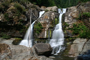
The South Fork Coquille River has two major waterfalls, situated in a steep and remote canyon just upstream of the first major northward bend of its course. These are the 35 feet (10.7 m) Upper Coquille River Falls, and the much larger 110 feet (33.5 m) Coquille River Falls.
The watershed is sparsely populated, with most of the people concentrated in the towns of Powers and Myrtle Point. Anadromous fish including salmon
and steelhead inhabit much of the river, but some habitat has been compromised due to poor watershed management practices such as excessive logging
and clearing.
Coquille River
The Coquille River is a stream long, in southwestern Oregon in the United States. It drains a mountainous area of of the Southern Oregon Coast Range into the Pacific Ocean. Its watershed is located between that of the Coos River to the north and the Rogue River to the south.-Geography:The river,...
in coastal Oregon
Oregon
Oregon is a state in the Pacific Northwest region of the United States. It is located on the Pacific coast, with Washington to the north, California to the south, Nevada on the southeast and Idaho to the east. The Columbia and Snake rivers delineate much of Oregon's northern and eastern...
in the United States
United States
The United States of America is a federal constitutional republic comprising fifty states and a federal district...
. From its headwaters in the Oregon Coast Range
Oregon Coast Range
The Oregon Coast Range, often called simply the Coast Range and sometimes the Pacific Coast Range, is a mountain range, in the Pacific Coast Ranges physiographic region, in the U.S. state of Oregon along the Pacific Ocean...
, the river flows northwest to join the North Fork Coquille River
North Fork Coquille River
The North Fork Coquille River is a tributary of the Coquille River in the southern Oregon Coast Range in the U.S. State of Oregon.About long, it starts as the confluence of several gulches on the east slope of Coos Mountain. The river first flows north, but then turns west and south...
at Myrtle Point
Myrtle Point, Oregon
-2000 Census data:As of the census of 2000, there were 2,451 people, 988 households, and 674 families residing in the city. The population density was 1,529.5 people per square mile . There were 1,110 housing units at an average density of 692.7 per square mile...
, forming the main stem Coquille. The South Fork is about 62.8 miles (101.1 km) long, and its watershed
Drainage basin
A drainage basin is an extent or an area of land where surface water from rain and melting snow or ice converges to a single point, usually the exit of the basin, where the waters join another waterbody, such as a river, lake, reservoir, estuary, wetland, sea, or ocean...
drains roughly 600 mi2 of rural Coos County
Coos County, Oregon
-National protected areas:*Bandon Marsh National Wildlife Refuge*Oregon Islands National Wildlife Refuge *Siskiyou National Forest *Siuslaw National Forest - Incorporated cities:- Unincorporated communities and CDPs:-See also:...
.
It rises as a small stream draining out of Eden Valley, 2.5 miles (4 km) miles northwest of Mount Bolivar in the Siskiyou National Forest. Picking up scores of tributaries, such as Wooden Rock, Clear and Panther Creeks, the river gains volume as it rumbles southwest into a deep gorge. At the confluence with Rock Creek, the river abruptly swings north, receiving Johnson Creek from the left a few miles further downstream. Now a fairly large stream, the South Fork winds through canyons to the confluence with Coal Creek before entering an alluvial
Alluvium
Alluvium is loose, unconsolidated soil or sediments, eroded, deposited, and reshaped by water in some form in a non-marine setting. Alluvium is typically made up of a variety of materials, including fine particles of silt and clay and larger particles of sand and gravel...
valley near the small community of Powers
Powers, Oregon
Powers is a city in Coos County, Oregon, United States. The population was 689 at the 2010 census.It is 21 miles south of Oregon Route 42 at Myrtle Point on Powers Highway Powers is a city in Coos County, Oregon, United States. The population was 689 at the 2010 census.It is 21 miles south of...
.
Oregon Route 542
Oregon Route 542 is an Oregon state highway running from OR 42 near Myrtle Point to Powers. OR 542 is known as the Powers Highway No. 242...
, and passing Coquille Myrtle Grove State Park and Albert H. Powers Memorial State Park. About a mile downstream, Dement Creek enters fron the left and the terrain around the river transforms from hills to farmland. As it assumes a meandering course, the river passes Broadbent
Broadbent, Oregon
Broadbent is an unincorporated community in Coos County, Oregon, United States. Broadbent is located along Oregon Route 242 south of Myrtle Point. Broadbent has a post office with ZIP code 97414....
then the Middle Fork Coquille River, by far the largest tributary, enters from the right, marking the head of tide
Head of tide
Head of tide is the farthest point upstream where a river is affected by tidal fluctuations. This applies to rivers which flow into tidal bodies such as oceans, bays and sloughs. Though this point may vary due to storms and seasonal or annual differences in water flows, there is generally an...
. A few miles onward, the river passes Myrtle Point
Myrtle Point, Oregon
-2000 Census data:As of the census of 2000, there were 2,451 people, 988 households, and 674 families residing in the city. The population density was 1,529.5 people per square mile . There were 1,110 housing units at an average density of 692.7 per square mile...
and meets the North Fork to form the Coquille River, 36.3 miles (58.4 km) upstream of the Pacific Ocean
Pacific Ocean
The Pacific Ocean is the largest of the Earth's oceanic divisions. It extends from the Arctic in the north to the Southern Ocean in the south, bounded by Asia and Australia in the west, and the Americas in the east.At 165.2 million square kilometres in area, this largest division of the World...
.
The South Fork Coquille River has two major waterfalls, situated in a steep and remote canyon just upstream of the first major northward bend of its course. These are the 35 feet (10.7 m) Upper Coquille River Falls, and the much larger 110 feet (33.5 m) Coquille River Falls.
The watershed is sparsely populated, with most of the people concentrated in the towns of Powers and Myrtle Point. Anadromous fish including salmon
Salmon
Salmon is the common name for several species of fish in the family Salmonidae. Several other fish in the same family are called trout; the difference is often said to be that salmon migrate and trout are resident, but this distinction does not strictly hold true...
and steelhead inhabit much of the river, but some habitat has been compromised due to poor watershed management practices such as excessive logging
Logging
Logging is the cutting, skidding, on-site processing, and loading of trees or logs onto trucks.In forestry, the term logging is sometimes used in a narrow sense concerning the logistics of moving wood from the stump to somewhere outside the forest, usually a sawmill or a lumber yard...
and clearing.