
Oregon Route 542
Encyclopedia
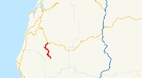
Oregon Route 542 is an Oregon
state highway
running from OR 42 near Myrtle Point
to Powers
. OR 542 is known as the Powers Highway No. 242 (see Oregon highways and routes). It is 18.78 miles (30.2 km) long and runs north–south, entirely within Coos County
.
OR 542 was established in 2003 as part of Oregon's project to assign route numbers to highways that previously were not assigned, and, as of August 2008, was unsigned.
, Warner, and Gaylord
to Powers, where it ends at an intersection with Railroad Avenue and Powers South Road.
Oregon
Oregon is a state in the Pacific Northwest region of the United States. It is located on the Pacific coast, with Washington to the north, California to the south, Nevada on the southeast and Idaho to the east. The Columbia and Snake rivers delineate much of Oregon's northern and eastern...
state highway
State highway
State highway, state road or state route can refer to one of three related concepts, two of them related to a state or provincial government in a country that is divided into states or provinces :#A...
running from OR 42 near Myrtle Point
Myrtle Point, Oregon
-2000 Census data:As of the census of 2000, there were 2,451 people, 988 households, and 674 families residing in the city. The population density was 1,529.5 people per square mile . There were 1,110 housing units at an average density of 692.7 per square mile...
to Powers
Powers, Oregon
Powers is a city in Coos County, Oregon, United States. The population was 689 at the 2010 census.It is 21 miles south of Oregon Route 42 at Myrtle Point on Powers Highway Powers is a city in Coos County, Oregon, United States. The population was 689 at the 2010 census.It is 21 miles south of...
. OR 542 is known as the Powers Highway No. 242 (see Oregon highways and routes). It is 18.78 miles (30.2 km) long and runs north–south, entirely within Coos County
Coos County, Oregon
-National protected areas:*Bandon Marsh National Wildlife Refuge*Oregon Islands National Wildlife Refuge *Siskiyou National Forest *Siuslaw National Forest - Incorporated cities:- Unincorporated communities and CDPs:-See also:...
.
OR 542 was established in 2003 as part of Oregon's project to assign route numbers to highways that previously were not assigned, and, as of August 2008, was unsigned.
Route description
OR 542 begins at an intersection with OR 42 approximately two miles southeast of Myrtle Point and heads south through BroadbentBroadbent, Oregon
Broadbent is an unincorporated community in Coos County, Oregon, United States. Broadbent is located along Oregon Route 242 south of Myrtle Point. Broadbent has a post office with ZIP code 97414....
, Warner, and Gaylord
Gaylord, Oregon
Gaylord is an unincorporated community in Coos County, Oregon, United States. It is located about 12 miles south of Myrtle Point on Oregon Route 542, near the South Fork Coquille River....
to Powers, where it ends at an intersection with Railroad Avenue and Powers South Road.
Major intersections
| Milepost | City | Intersection |
|---|---|---|
| 0.00 | Near Myrtle Point Myrtle Point, Oregon -2000 Census data:As of the census of 2000, there were 2,451 people, 988 households, and 674 families residing in the city. The population density was 1,529.5 people per square mile . There were 1,110 housing units at an average density of 692.7 per square mile... |
OR 42 |
| 18.91 | Powers Powers, Oregon Powers is a city in Coos County, Oregon, United States. The population was 689 at the 2010 census.It is 21 miles south of Oregon Route 42 at Myrtle Point on Powers Highway Powers is a city in Coos County, Oregon, United States. The population was 689 at the 2010 census.It is 21 miles south of... |
Railroad Avenue and Powers South Road (End route) |