
Coquille River
Encyclopedia
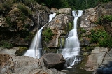
The Coquille River is a stream 36.3 miles (58.4 km) long, in southwestern Oregon
in the United States
. It drains a mountainous area of 1059 mi2 of the Southern Oregon Coast Range
into the Pacific Ocean
. Its watershed is located between that of the Coos River
to the north and the Rogue River
to the south.
. The North Fork Coquille River
, 53.3 miles (85.8 km) long), rises in northern Coos County
and flows southwest. The East Fork, 33.8 miles (54.4 km) long, rises in eastern Coos County, and flows generally west to join the North Fork.
The South Fork
, 62.8 miles (101.1 km) long, rises in southern Coos County, north of the Wild Rogue Wilderness Area
, and flows generally north. It receives the Middle Fork, 40.3 miles (64.9 km) long, then joins the North Fork from the south at Myrtle Point. The combined river meanders generally west, past Coquille
. It enters the Pacific at Bandon
, about 20 miles (32.2 km) north of Cape Blanco
.
is 41 miles upriver from the mouth at Bandon. But some salt water does enter across the bar. The salt water intrusion was once minor. Today, however, sometimes traces of salinity appear only a few miles below the town of Coquille. This phenomenon affects industry along the river, as mills and other sites need fresh water intakes on the river in order not to rust or damage equipment or affect production processes.
On its main forks, the Coquille is also an alluvial river valley, meaning it was once a drowned river valley—a lake, or perhaps a much wider river, with a sandy bottom. The soil in the valley is very fertile. However, the rise and fall of the water level, and flooding in winter, prevent ordinary types of farming. A lush grass grows in the valley lowlands which can survive either drought or inundation. Tide-gates along the river can bring in water when needed. On this sweeping stand of grass, in summer many cattle find pasture.
 Captain Judah Parker, a sea captain, built a jetty of bunches of cedar branches wrapped in burlap, sunken into the mud. Rocks were added. In the late 1890s, the government built jetties to force the channel to stay put. Huge boulders for the South Jetty, at Bandon, came from the blasting of a nearby mound of rock called Tupper Rock. The North Jetty is across the river, and clearly visible from the south jetty.
The Coquille River Light
house, commissioned in 1896, guided mariners to find the dangerous bar at the mouth of the Coquille. The lighthouse was built on or near Rackleff Rock, a rocky obstacle in the channel. The rock became part of the bulwark of the North Jetty area. The lighthouse was decommissioned in 1939, following the last of improvements to the river channel.
The pioneer Hamblock and Bullards families had ranches in that region. But eventually their lands became part of the present Bullards Beach State Park
. The old lighthouse building still stands. It is now a tourist attraction.
, Jules Verne
depicted a fictional Utopian community named Ville-France being created in 1872 at the Coquille River's confluence with the Pacific, slightly south-west of the actual site of Bandon
.
Oregon
Oregon is a state in the Pacific Northwest region of the United States. It is located on the Pacific coast, with Washington to the north, California to the south, Nevada on the southeast and Idaho to the east. The Columbia and Snake rivers delineate much of Oregon's northern and eastern...
in the United States
United States
The United States of America is a federal constitutional republic comprising fifty states and a federal district...
. It drains a mountainous area of 1059 mi2 of the Southern Oregon Coast Range
Southern Oregon Coast Range
The Southern Oregon Coast Range is the southernmost section of the Oregon Coast Range, in the Pacific Coast Ranges, located in the southwest portion of the state of Oregon, United States roughly between the Umpqua River and the middle fork of the Coquille River, beyond which are the Klamath...
into the Pacific Ocean
Pacific Ocean
The Pacific Ocean is the largest of the Earth's oceanic divisions. It extends from the Arctic in the north to the Southern Ocean in the south, bounded by Asia and Australia in the west, and the Americas in the east.At 165.2 million square kilometres in area, this largest division of the World...
. Its watershed is located between that of the Coos River
Coos River
The Coos River flows for about into Coos Bay along the Pacific coast of southwest Oregon in the United States. Formed by the confluence of its major tributaries, the South Fork Coos River and the Millicoma River, it drains an important timber-producing region of the Southern Oregon Coast Range...
to the north and the Rogue River
Rogue River (Oregon)
The Rogue River in southwestern Oregon in the United States flows about in a generally westward direction from the Cascade Range to the Pacific Ocean. Known for its salmon runs, whitewater rafting, and rugged scenery, it was one of the original eight rivers named in the Wild and Scenic Rivers Act...
to the south.
Geography
The river, formed by the confluence of its north and south forks, begins at Myrtle PointMyrtle Point, Oregon
-2000 Census data:As of the census of 2000, there were 2,451 people, 988 households, and 674 families residing in the city. The population density was 1,529.5 people per square mile . There were 1,110 housing units at an average density of 692.7 per square mile...
. The North Fork Coquille River
North Fork Coquille River
The North Fork Coquille River is a tributary of the Coquille River in the southern Oregon Coast Range in the U.S. State of Oregon.About long, it starts as the confluence of several gulches on the east slope of Coos Mountain. The river first flows north, but then turns west and south...
, 53.3 miles (85.8 km) long), rises in northern Coos County
Coos County, Oregon
-National protected areas:*Bandon Marsh National Wildlife Refuge*Oregon Islands National Wildlife Refuge *Siskiyou National Forest *Siuslaw National Forest - Incorporated cities:- Unincorporated communities and CDPs:-See also:...
and flows southwest. The East Fork, 33.8 miles (54.4 km) long, rises in eastern Coos County, and flows generally west to join the North Fork.
The South Fork
South Fork Coquille River
The South Fork Coquille River is the largest tributary of the Coquille River in coastal Oregon in the United States. From its headwaters in the Oregon Coast Range, the river flows northwest to join the North Fork Coquille River at Myrtle Point, forming the main stem Coquille...
, 62.8 miles (101.1 km) long, rises in southern Coos County, north of the Wild Rogue Wilderness Area
Wild Rogue Wilderness
The Wild Rogue Wilderness is a wilderness area surrounding the eighty-four mile Wild and Scenic portion of the Rogue River in southwestern Oregon, U.S. to protect the watershed. The Wilderness was established in 1987 and now comprises...
, and flows generally north. It receives the Middle Fork, 40.3 miles (64.9 km) long, then joins the North Fork from the south at Myrtle Point. The combined river meanders generally west, past Coquille
Coquille, Oregon
Coquille is a city that is the county seat of Coos County, Oregon, United States. The population was 4,184 at the 2000 census. The 2007 estimate is 4,215 residents. The primary economic base is the timber industry...
. It enters the Pacific at Bandon
Bandon, Oregon
- Economy :Like many communities on the Oregon coast, Bandon had significant fishing and timber industries, which were greatly diminished by the 1980s, though some remnants still exist. Bandon's current economy revolves around wood products, fishing, tourism, and agriculture...
, about 20 miles (32.2 km) north of Cape Blanco
Cape Blanco (Oregon)
Cape Blanco is a prominent headland on the Pacific Ocean coast of southwestern Oregon in the United States, forming the westernmost point in the state. It contests with Cape Alava in Washington for the title of westernmost point in the contiguous United States...
.
Tidal effect
The Coquille River is a tidal-effect river. During high tides at sea, the water at the mouth of the river acts like a dam, impeding the flow of the stream. Actually, more water always flows out into the ocean than enters with the tide. However, logs or sticks or leaves on the surface actually float up the river at certain times of day. There is a time lag between the high tide at sea and the effect pushing upstream. This varies according to the number of miles from the ocean. The tidal-effect is observed as far as Myrtle Point, some 28 to 30 miles upriver. The head of tideHead of tide
Head of tide is the farthest point upstream where a river is affected by tidal fluctuations. This applies to rivers which flow into tidal bodies such as oceans, bays and sloughs. Though this point may vary due to storms and seasonal or annual differences in water flows, there is generally an...
is 41 miles upriver from the mouth at Bandon. But some salt water does enter across the bar. The salt water intrusion was once minor. Today, however, sometimes traces of salinity appear only a few miles below the town of Coquille. This phenomenon affects industry along the river, as mills and other sites need fresh water intakes on the river in order not to rust or damage equipment or affect production processes.
On its main forks, the Coquille is also an alluvial river valley, meaning it was once a drowned river valley—a lake, or perhaps a much wider river, with a sandy bottom. The soil in the valley is very fertile. However, the rise and fall of the water level, and flooding in winter, prevent ordinary types of farming. A lush grass grows in the valley lowlands which can survive either drought or inundation. Tide-gates along the river can bring in water when needed. On this sweeping stand of grass, in summer many cattle find pasture.
History
In its natural state, the Coquille River meandered widely at its mouth. Owing to storms, tides, or other conditions, the river could empty into the sea as far north as a beach now called Whiskey Run, or as far south as a rock formation called Table Rock—an overall distance of several miles. It is said that when early sailing vessels tried to cross the dangerous bar to return to the port at Bandon, the main channel might have moved, or shoaled in, at the very place the ships had crossed safely on the outgoing journey.The Coquille River Light
Coquille River Light
Coquille River Light is a lighthouse located near Bandon, Oregon, United States. It is currently maintained by the Oregon Parks and Recreation Department as a part of Bullards Beach State Park.-History:...
house, commissioned in 1896, guided mariners to find the dangerous bar at the mouth of the Coquille. The lighthouse was built on or near Rackleff Rock, a rocky obstacle in the channel. The rock became part of the bulwark of the North Jetty area. The lighthouse was decommissioned in 1939, following the last of improvements to the river channel.
The pioneer Hamblock and Bullards families had ranches in that region. But eventually their lands became part of the present Bullards Beach State Park
Bullards Beach State Park
Bullards Beach State Park is a state park in the U.S. state of Oregon, administered by the Oregon Parks and Recreation Department....
. The old lighthouse building still stands. It is now a tourist attraction.
Literary setting
In his early science fiction book The Begum's MillionsThe Begum's Millions
The Begum's Fortune , also published as The Begum's Millions, is an 1879 novel by Jules Verne, with some elements which could be described as utopian and others which seem clearly dystopian. It is remarkable as the first published book in which Verne was cautionary and to some degree pessimistic...
, Jules Verne
Jules Verne
Jules Gabriel Verne was a French author who pioneered the science fiction genre. He is best known for his novels Twenty Thousand Leagues Under the Sea , A Journey to the Center of the Earth , and Around the World in Eighty Days...
depicted a fictional Utopian community named Ville-France being created in 1872 at the Coquille River's confluence with the Pacific, slightly south-west of the actual site of Bandon
Bandon, Oregon
- Economy :Like many communities on the Oregon coast, Bandon had significant fishing and timber industries, which were greatly diminished by the 1980s, though some remnants still exist. Bandon's current economy revolves around wood products, fishing, tourism, and agriculture...
.
See also
- List of rivers of Oregon
- List of longest streams of Oregon
- Menai Strait#Tidal effects
- FirthFirthFirth is the word in the Lowland Scots language and in English used to denote various coastal waters in Scotland and England. In mainland Scotland it is used to describe a large sea bay, or even a strait. In the Northern Isles it more usually refers to a smaller inlet...
(tidal effects) - Steamboats of the Coquille RiverSteamboats of the Coquille RiverThe Coquille River starts in the Siskiyou National Forest and flows hundreds of miles through the Coquille Valley on its way to the Pacific Ocean. Bandon, Oregon, sits at the mouth of the Coquille River on the Pacific Ocean...