

Skeggs Point, California
Encyclopedia

San Mateo County, California
San Mateo County is a county located in the San Francisco Bay Area of the U.S. state of California. It covers most of the San Francisco Peninsula just south of San Francisco, and north of Santa Clara County. San Francisco International Airport is located at the northern end of the county, and...
along State Route 35
California State Route 35
State Route 35 in the U.S. state of California, generally known as Skyline Boulevard, is a two-lane road running along the western ridge of Silicon Valley in California. It runs from Highway 17 to San Francisco at State Route 1. It provides scenic views of both the Santa Cruz Mountains, the...
between Kings Mountain
Kings Mountain, California
Kings Mountain is an unincorporated community in San Mateo County, California, located along State Route 35 between Skeggs Point and Pise Mountain. This is about seven miles north of Woodside Road . In the U.S...
and State Route 84
California State Route 84
State Route 84 is a split-section California State Highway consisting of two sections. The first section is an east–west arterial road running from San Gregorio to Menlo Park, across the Dumbarton Bridge through Fremont and Newark and ending at I-580 in Livermore. The route overlaps the...
. The feature is marked with a guide sign along the road and is listed on the USGS 7.5 minute quadrangle, "Woodside, California
Woodside, California
Woodside is a small incorporated town in San Mateo County, California, United States, on the San Francisco Peninsula. It uses a council-manager system of government. The U.S. Census estimated the population of the town to be 5,287 in 2010....
" as well as in the National Geographic Names Database. The area is about three miles (five kilometers) west, and 2,000 feet (600 m) above the town of Woodside
Woodside, California
Woodside is a small incorporated town in San Mateo County, California, United States, on the San Francisco Peninsula. It uses a council-manager system of government. The U.S. Census estimated the population of the town to be 5,287 in 2010....
.
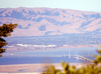
If not for the vegetation, there is a panoramic view of the San Francisco Bay
San Francisco Bay
San Francisco Bay is a shallow, productive estuary through which water draining from approximately forty percent of California, flowing in the Sacramento and San Joaquin rivers from the Sierra Nevada mountains, enters the Pacific Ocean...
south of Candlestick Park, (a.k.a. Monster Park, 3Com Park). Skeggs Point is about 2,300 feet (700 m) above mean sea level
Sea level
Mean sea level is a measure of the average height of the ocean's surface ; used as a standard in reckoning land elevation...
, (AMSL). NAD83 coordinates for the location are 37.4109°N 122.3056 °W. The USGS shows a benchmark of 2315 ft (706 m) at the vista point.
A peak named Sierra Morena (elevation 2417 ft (737 m)) is a prominent local feature about 100 feet (30 m) west of the Skeggs Point turn-out. One of the highest points in San Mateo County (according to U.S. Geological Survey maps), Sierra Morena is closed to the public because of communication antennas and microwave equipment. Land along the roadway is largely owned by a Special District, the Midpeninsula Regional Open Space District
Midpeninsula Regional Open Space District
The Midpeninsula Regional Open Space District is a special-purpose district that manages over of open space in 25 preserves in the San Francisco Bay Area. It includes parts of Santa Clara, San Mateo and Santa Cruz Counties. The District was created by voter initiative in 1972...
.
Named for Caltrans District 4 engineer

California Department of Transportation
The California Department of Transportation is a government department in the U.S. state of California. Its mission is to improve mobility across the state. It manages the state highway system and is actively involved with public transportation systems throughout the state...
(Caltrans) District 4 engineer from roughly 1919 until his retirement in 1952. Skeggs was a high-profile factor in early Caltrans District 4 project work building US 101, SR 35, SR 152
California State Route 152
State Route 152 is a state highway that runs near the latitudinal middle of the U.S. state of California from Watsonville to Route 99 southeast of Merced...
through Pacheco Pass
Pacheco Pass
Pacheco Pass, elevation , is a mountain pass located in the Diablo Range in southeastern Santa Clara County, California. It is the main road over the hills separating the Santa Clara Valley and the Central Valley....
, the Waldo Tunnel, the Altamont Pass
Altamont Pass
Altamont Pass, formerly Livermore Pass, is a mountain pass in the Diablo Range between Livermore in the Livermore Valley and Tracy in the San Joaquin Valley in Northern California...
(then US 50 and now part of I-580
Interstate 580 (California)
Interstate 580 is an 80-mile east–west Interstate Highway in Northern California. The heavily traveled spur route of Interstate 80 runs from San Rafael in the San Francisco Bay Area to Interstate 5 near Tracy in the Central Valley...
), as well as a pre-1952 El Camino Real
El Camino Real (California)
El Camino Real and sometimes associated with Calle Real usually refers to the 600-mile California Mission Trail, connecting the former Alta California's 21 missions , 4 presidios, and several pueblos, stretching from Mission San Diego de Alcalá in San Diego...
widening project. Before the war, he worked for the City of Los Angeles
Los Angeles, California
Los Angeles , with a population at the 2010 United States Census of 3,792,621, is the most populous city in California, USA and the second most populous in the United States, after New York City. It has an area of , and is located in Southern California...
Department of Water and Power
Los Angeles Department of Water and Power
The Los Angeles Department of Water and Power is the largest municipal utility in the United States, serving over four million residents. It was founded in 1902 to supply water and electricity to residents and businesses in Los Angeles and surrounding communities...
, (DWP).
Col. Skeggs died 28 August 1959 in Santa Clara, California
Santa Clara, California
Santa Clara , founded in 1777 and incorporated in 1852, is a city in Santa Clara County, in the U.S. state of California. The city is the site of the eighth of 21 California missions, Mission Santa Clara de Asís, and was named after the mission. The Mission and Mission Gardens are located on the...
.
Sources
- Beal, Richard, Highway 17: The Road to Santa Cruz, (Aptos, Calif.: Pacific Group, 1991).
- Woodside, California, 7.5 minute Quadrangle, US Geological Survey, 1997.
- AncestryLibrary.com (death record information).
- Photo courtesy of Auburn University.
External links
- This area may be in the Woodside Fire District