

South Coast railway line, New South Wales
Encyclopedia
The South Coast Line is in the intercity region of Sydney
's CityRail
services. It serves the coastal region to the south of the Sydney metropolitan area including the Illawarra
region, most notably the regional city of Wollongong, and extended services reach as far as Nowra
in Shoalhaven
.
to its terminus in Bomaderry
. CityRail currently markets the suburban services to Waterfall and Cronulla as the Illawarra line and interurban services south to Wollongong and Bomaderry as the South Coast line.
. From the Illawarra junction, four tracks head south through the stations of Erskineville and St Peters to Sydenham
. Immediately north of Erskineville station, the Illawarra lines are connected to the Illawarra Relief Lines which emerge from underground. These lines form the Eastern Suburbs line which opened in 1979. Heading south from Erskineville, the eastern-most pair of tracks are the Up and Down Illawarra lines which usually carry the Illawarra line passenger services.
The western-most pair of tracks are the Up and Down Illawarra local tracks which usually carry Bankstown and East Hills line express trains. To the west of the four tracks between Erskineville and Sydenham lies a reservation for a further pair of tracks with partially constructed platforms at Erskineville and St Peters stations. There are current plans to complete these tracks under the Rail Clearways
plan, these tracks will be known as the Up and Down Illawarra relief lines.
At Sydenham, six platforms are provided, with Bankstown line services generally using the western-most pair (platforms 1 and 2), East Hills peak hour services using the inner pair (platforms 3 and 4) and Illawarra line services using the easternmost pair of platforms (platforms 5 and 6). South of Sydenham, the Bankstown line branches off in a westwards direction. The Botany Goods Line crosses over the Illawarra line via a flyover. The line then reaches Tempe station, before crossing the Cooks River
.
South of the Cooks River lies Wolli Creek station, where the East Hills line branches off to the west. The Illawarra line continues south as four tracks through a rock cutting to the stations of Arncliffe (2 island platforms), Banksia (2 side platforms and an island platform) and Rockdale. Rockdale station has five platforms, platform 1 (the most westerly platform) is currently unelectrified and disused but was previously a terminating point for electric passenger trains. South of Rockdale, the line passes through Kogarah station (one island platform 2 & 3 and 2 side platforms 1 & 4) which has a shopping centre built overhead. The line the makes a westerly turn, heading through Carlton
and Allawah stations (both with two island platforms).
The next station is Hurstville (2 island platforms), which is where the four track section ends and terminating facilities are provided. Like Kogarah, Hurstville has a shopping centre built above the platforms. South of Hurstville, the line becomes 2 tracks with bidirectional signalling. The line passes through Penshurst
and Mortdale (island platforms). At Mortdale is the Mortdale maintenance depot which lies on the eastern side of the tracks with access points from the south of the station. The line then continues to Oatley which has an island platform and a set of points
allowing trains to be turned-back. The line then crosses the Georges River
over the Como Bridge, which opened in 1972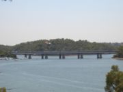 replacing an older single track bridge which still exists to the east of the present structure and is used as a cycleway. The line enters the Sutherland Shire
, passing through Como station
(which was moved to its present, new site with the opening of the new bridge in 1972), and Jannali (side platforms) before reaching Sutherland.
At Sutherland, three platforms are provided. The Cronulla Line branches off in an eastwards direction south of the station. The former short branch line to Woronora Cemetery branched in a westerly direction at the south of the platforms. The line opened on 28 July 1900 and closed on 27 August 1944. The line then continues south through Loftus
, Engadine, and Heathcote (all side platform stations). South of Loftus, the former Royal National Park line branched off, this has now been converted into a tram line connecting to the Sydney Tramway Museum
, and connections to the mainline have been severed. The final station for the operation of suburban services is Waterfall station
, which is an island platform. At Waterfall, there is a train stabling yard and a train turnback (shunting road) south of the station. South of Waterfall is the site of the 2003 Waterfall train disaster
.
 The line then heads south through the challenging terrain of the Royal National Park
and Illawarra escarpment. The line makes a steep descent down to Wollongong
. The original alignment through the towns of Helensburgh
and Lilyvale which opened in 1888 was bypassed by a new route in 1915. A new station at Helensburgh (island platform) was subsequently opened with the new alignment. A set of points
allows the turnback of trains at Helensburgh. The line then proceeds through several tunnels down the Illawarra escarpment through the hamlets of Stanwell Park
and Coalcliff.
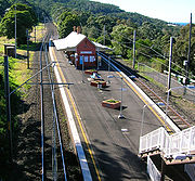
South of Coalcliff, the line becomes single track as it passes through the Clifton Tunnel, before becoming double track again near Scarborough station. The line then proceeds south through the northern suburbs of Wollongong, then Wollongong and its southern suburbs. A terminating platform is provided at Thirroul, which is used to terminate peak hour services from Sydney, as well as local services.
At Coniston
south of Wollongong, an electrified branch line heads east to Port Kembla
. At Unanderra, the line to Moss Vale branches off to head west over the Illawarra escarpment to join the Main South line
. Double tracking ends at Unanderra, and the line continues south as a single line track. The line continues south through Kembla Grange where a simple platform serves the Kembla Grange racecourse. The line then reaches Dapto where a passing loop is provided. Dapto was the southern extent of electrification until 2001
The line then passes south through the hamlet of Albion Park Rail
(where another crossing loop is provided) to reach Kiama, the current extent of electrification. South of Kiama, the line continues as a single track non-electrified line through rolling dairy pastures via several tunnels to the towns of Gerringong
and Berry
before arriving at its terminus at the town of Bomaderry on the northern bank of the Shoalhaven River
. At Bomaderry, sidings connect to The Manildra Group's starch mill.
 At Coniston
, an electrified branch line proceeds east to the industrial suburb of Port Kembla
with three intermediate stations.
The line is double track as far as just west of Port Kembla North and is used by freight trains as well as local CityRail
passenger services. A stabling yard is provided at Port Kembla for overnight storage of electric trains.
|}
|}
|}
|}
|}
|}
|}
|}
A Sydney to Kiama railway was authorised by the New South Wales Parliament in April 1881. Construction of the various sections was awarded by tender and commenced in October 1882.
The Illawarra Line branched off the Main Suburban Railway south of Redfern, at Eveleigh
(Illawarra Junction). The line opened to Hurstville in 1884, Sutherland in 1885, Waterfall
in 1886 and Clifton through to Wollongong and North Kiama (Bombo) in 1887. The missing Waterfall to Clifton section comprised four large brick-arch culverts (and many small ones) and eight tunnels with a total length of over 4 km, delaying its opening until 1888. Kiama and Bomaderry (servicing Nowra
) opened in 1893. The line was originally double track to Hurstville and continued as a single track, but was duplicated to Waterfall (except for the Como
to Sutherland section) in 1890. In 1886 a branch line was opened to Audley
in the Royal National Park
, which closed in 1991.
A steep ruling grade of 1 in 40 faced up (Sydney bound) trains almost all the way between Stanwell Park station and Otford. The main problem was the 1550 m long Otford Tunnel, which took the railway through Bald Hill from the coast at Stanwell Park to the Hacking River
valley. The steep 1 in 40 grade and tight clearances meant that soot, smoke and heat could become unbearable, especially when a south-easterly wind blew into the southern portal or when a train stalled in the tunnel. A Mr B Chamberlain wrote about a stalled passenger train in 1890:
Regarding the crew, Chamberlain wrote:
Attempts were made to overcome the problem with a ventilation shaft and chimney in the early 1890s and a blower system installed in 1909.
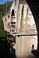
Many goods trains were routinely divided at Stanwell Park and taken through to Waterfall in stages, effectively increasing the number of train movements on the line. The increasing congestion and steepness led to construction of a double track deviation, which opened between Waterfall and Helensburgh in 1914, Helensburgh and Otford in 1915, and Otford and Coalcliff (bypassing the by now infamous Otford Tunnel) in 1920. The deviation avoided the steep grades with a more winding route featuring sharp curves, deep cuttings, new tunnels and a curved viaduct
over Stanwell Creek that required 3 million bricks in its construction. Although the new route was 5 km longer it reduced the ruling grade from 1 in 40 to around 1 in 80. Of the original eight tunnels in this section only the Clifton Tunnel remains in use and is the only single track section between Sydney and Unanderra.
In 1924, work began on a 57 km line connecting Unanderra with Moss Vale on the Great Southern line
, which opened in 1932. It enabled the transportation of limestone
from the Southern Highlands
to the coast at Port Kembla
. See: Unanderra - Moss Vale railway line.
Electrification of the South Coast Line was completed in stages reaching from Sydney to Loftus
in 1926, Waterfall in 1980, Helensburgh in 1984, Wollongong in 1985-86, Dapto in 1993 and Kiama in 2001. The Kiama to Nowra section remains unelectrified.
Major structural problems with the Stanwell Creek viaduct were identified in late 1985, with one span close to collapsing and another badly cracked, requiring substantial repairs and stabilising work.
On 31 January 2003, an Intercity Tangara passenger train (G7) derailed at high speed south of Waterfall station after its driver suffered a heart attack. The Waterfall train disaster
resulted in seven fatalities and multiple injuries.
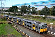
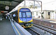 The South Coast line passenger services currently consist of electric double deck multiple unit trains that operate between Bondi Junction or Central and either Wollongong, Kiama or Port Kembla. Diesel shuttle trains connect at Wollongong or Kiama and operate to Nowra. Although electrified to Wollongong in 1985, several diesel trains operated between Sydney and Nowra until 1991, one of which was the South Coast Daylight Express, operated as a locomotive hauled train of Budd and Tulloch type passenger cars which included catering facilities.
Sydney
Sydney is the most populous city in Australia and the state capital of New South Wales. Sydney is located on Australia's south-east coast of the Tasman Sea. As of June 2010, the greater metropolitan area had an approximate population of 4.6 million people...
's CityRail
CityRail
CityRail is an operating brand of RailCorp, a corporation owned by the state government of New South Wales, Australia. It is responsible for providing commuter rail services, and some coach services, in and around Sydney, Newcastle and Wollongong, the three largest cities of New South Wales. It is...
services. It serves the coastal region to the south of the Sydney metropolitan area including the Illawarra
Illawarra
Illawarra is a region in the Australian state of New South Wales. It is a coastal region situated immediately south of Sydney and north of the Shoalhaven or South Coast region. It encompasses the cities of Wollongong, Shellharbour, Shoalhaven and the town of Kiama. The central region contains Lake...
region, most notably the regional city of Wollongong, and extended services reach as far as Nowra
Nowra, New South Wales
Nowra is a city in the South Coast region of New South Wales, Australia. Located SSW and approximately by road south of the state capital of Sydney, it has an estimated population together with its twin-town of Bomaderry of 34,479. It is also the seat and commercial centre of the City of Shoalhaven...
in Shoalhaven
Shoalhaven
The City of Shoalhaven is a Local Government Area in south-eastern New South Wales , Australia, two hours south of Sydney. It is more or less conterminous with an area referred to as The Shoalhaven. It is on the Pacific Ocean and the Princes Highway and is the terminus of the South Coast line...
.
Line naming
The line is operationally and historically known as the Illawarra Line throughout its length from the Illawarra Junction at RedfernRedfern, New South Wales
Redfern is an inner-city suburb of Sydney. Redfern is 3 kilometres south of the Sydney central business district and is part of the local government area of the City of Sydney...
to its terminus in Bomaderry
Bomaderry, New South Wales
Bomaderry is a town in the Shoalhaven council district area of New South Wales, Australia. In 2006, it had a population of 6,601 people. It is on the north shore of the Shoalhaven River, across the river from Nowra, the major town of the Shoalhaven,of which Bomaderry is locally regarded as being...
. CityRail currently markets the suburban services to Waterfall and Cronulla as the Illawarra line and interurban services south to Wollongong and Bomaderry as the South Coast line.
Suburban section
The South Coast (Illawarra) line commences at the Illawarra Junction at Redfern. Here, a dive-under allows inter-city services from the South Coast line to cross underneath the main suburban railway lines to access Sydney TerminalCentral railway station, Sydney
Central Railway Station, the largest railway station in Australia, is at the southern end of the Sydney CBD. It services almost all the lines on the CityRail network, and is the major terminus for interurban and interstate rail services...
. From the Illawarra junction, four tracks head south through the stations of Erskineville and St Peters to Sydenham
Sydenham railway station, Sydney
Sydenham railway station is a major interchange station located in the small Sydney suburb of Sydenham, serving the East Hills, Illawarra and Bankstown lines on the CityRail system. The Illawarra line platforms are also used by a very small number of South Coast line services. The station is...
. Immediately north of Erskineville station, the Illawarra lines are connected to the Illawarra Relief Lines which emerge from underground. These lines form the Eastern Suburbs line which opened in 1979. Heading south from Erskineville, the eastern-most pair of tracks are the Up and Down Illawarra lines which usually carry the Illawarra line passenger services.
The western-most pair of tracks are the Up and Down Illawarra local tracks which usually carry Bankstown and East Hills line express trains. To the west of the four tracks between Erskineville and Sydenham lies a reservation for a further pair of tracks with partially constructed platforms at Erskineville and St Peters stations. There are current plans to complete these tracks under the Rail Clearways
CityRail Clearways Project
The CityRail Clearways Project is a $1.8 billion program of public works on Sydney's CityRail suburban railway network to "untangle" the excessively intertwined and complicated rail network...
plan, these tracks will be known as the Up and Down Illawarra relief lines.
At Sydenham, six platforms are provided, with Bankstown line services generally using the western-most pair (platforms 1 and 2), East Hills peak hour services using the inner pair (platforms 3 and 4) and Illawarra line services using the easternmost pair of platforms (platforms 5 and 6). South of Sydenham, the Bankstown line branches off in a westwards direction. The Botany Goods Line crosses over the Illawarra line via a flyover. The line then reaches Tempe station, before crossing the Cooks River
Cooks River
The Cooks River is a 23 kilometre long urban waterway of south-western Sydney, New South Wales, Australia emptying into Botany Bay. The course of the river has been altered to accommodate various developments along its shore...
.
South of the Cooks River lies Wolli Creek station, where the East Hills line branches off to the west. The Illawarra line continues south as four tracks through a rock cutting to the stations of Arncliffe (2 island platforms), Banksia (2 side platforms and an island platform) and Rockdale. Rockdale station has five platforms, platform 1 (the most westerly platform) is currently unelectrified and disused but was previously a terminating point for electric passenger trains. South of Rockdale, the line passes through Kogarah station (one island platform 2 & 3 and 2 side platforms 1 & 4) which has a shopping centre built overhead. The line the makes a westerly turn, heading through Carlton
Carlton railway station, Sydney
-Accessibility:The station was upgraded to Easy Access status in 2008 with the provision of four lifts connecting Carlton Parade and Railway Parade and the platforms.-Transport links:Veolia Transport runs one route via Carlton station:...
and Allawah stations (both with two island platforms).
The next station is Hurstville (2 island platforms), which is where the four track section ends and terminating facilities are provided. Like Kogarah, Hurstville has a shopping centre built above the platforms. South of Hurstville, the line becomes 2 tracks with bidirectional signalling. The line passes through Penshurst
Penshurst railway station, Sydney
-Accessibility:The station has stairs and a ramp leading to an overbridge connected to a street on its southern end and stairs and a lift to the overbridge from a street on its northern end and has a lift leading down to the platforms and therefore has Easy Access for wheelchairs...
and Mortdale (island platforms). At Mortdale is the Mortdale maintenance depot which lies on the eastern side of the tracks with access points from the south of the station. The line then continues to Oatley which has an island platform and a set of points
Railroad switch
A railroad switch, turnout or [set of] points is a mechanical installation enabling railway trains to be guided from one track to another at a railway junction....
allowing trains to be turned-back. The line then crosses the Georges River
Georges River
The Georges River is a waterway in the state of New South Wales in Australia. It rises to the south-west of Sydney near the coal mining town of Appin, and then flows north past Campbelltown, roughly parallel to the Main South Railway...
over the Como Bridge, which opened in 1972
Sutherland Shire
The Sutherland Shire is a Local Government Area in the Southern Sydney region of Sydney, Australia. Geographically, it is the area to the south of Botany Bay and the Georges River...
, passing through Como station
Como railway station, Sydney
-Accessibility:The station has stairs leading to a subway connected to the streets on either side, and thus does not have Easy Access for wheelchairs.-Neighbouring stations:-References:...
(which was moved to its present, new site with the opening of the new bridge in 1972), and Jannali (side platforms) before reaching Sutherland.
At Sutherland, three platforms are provided. The Cronulla Line branches off in an eastwards direction south of the station. The former short branch line to Woronora Cemetery branched in a westerly direction at the south of the platforms. The line opened on 28 July 1900 and closed on 27 August 1944. The line then continues south through Loftus
Loftus railway station, Sydney
-Transport links:Veolia Transport runs two routes via Loftus station:*991 - between Sutherland and Heathcote*992 - between Miranda and Engadine-Neighbouring stations:-References:...
, Engadine, and Heathcote (all side platform stations). South of Loftus, the former Royal National Park line branched off, this has now been converted into a tram line connecting to the Sydney Tramway Museum
Sydney Tramway Museum
The Sydney Tramway Museum is an operating tramway museum, located in Loftus in the southern suburbs of Sydney, Australia. Sydney Tramway Museum is the trading name of the South Pacific Electric Railway ....
, and connections to the mainline have been severed. The final station for the operation of suburban services is Waterfall station
Waterfall railway station, Sydney
Waterfall railway station is a Sydney railway station serving the suburb of Waterfall, New South Wales and is the last stop of the suburban section of the Illawarra line. Waterfall station also provides access to Camp Coutts, a large Scout campsite. The station opened in 1886, moving to its present...
, which is an island platform. At Waterfall, there is a train stabling yard and a train turnback (shunting road) south of the station. South of Waterfall is the site of the 2003 Waterfall train disaster
Waterfall train disaster
The Waterfall rail accident was a train accident that occurred on 31 January 2003 near Waterfall, New South Wales, Australia. The train derailed, killing seven people aboard, including the train driver.-Incident:...
.
Inter-urban section
Royal National Park
Royal National Park is a national park in New South Wales, Australia, 29 km south of Sydney CBD.Founded by Sir John Robertson, Acting Premier of New South Wales, and formally proclaimed on 26 April 1879, it is the world's second oldest purposed national park, the first usage of the term...
and Illawarra escarpment. The line makes a steep descent down to Wollongong
Wollongong, New South Wales
Wollongong is a seaside city located in the Illawarra region of New South Wales, Australia. It lies on the narrow coastal strip between the Illawarra Escarpment and the Pacific Ocean, 82 kilometres south of Sydney...
. The original alignment through the towns of Helensburgh
Helensburgh, New South Wales
Helensburgh is a small town in New South Wales, Australia. Helensburgh is located 45 kilometres south of the Sydney central business district and north of Wollongong. Helensburgh is in the local government area of Wollongong City Council and marks the northern end of the Illawarra region...
and Lilyvale which opened in 1888 was bypassed by a new route in 1915. A new station at Helensburgh (island platform) was subsequently opened with the new alignment. A set of points
Railroad switch
A railroad switch, turnout or [set of] points is a mechanical installation enabling railway trains to be guided from one track to another at a railway junction....
allows the turnback of trains at Helensburgh. The line then proceeds through several tunnels down the Illawarra escarpment through the hamlets of Stanwell Park
Stanwell Park, New South Wales
Stanwell Park is a picturesque coastal village and northern suburb of Wollongong, New South Wales, Australia. It is the northernmost point of the Illawarra coastal strip and lies south of Sydney's Royal National Park. It is situated in a small valley between Bald Hill to the north, Stanwell Tops...
and Coalcliff.
South of Coalcliff, the line becomes single track as it passes through the Clifton Tunnel, before becoming double track again near Scarborough station. The line then proceeds south through the northern suburbs of Wollongong, then Wollongong and its southern suburbs. A terminating platform is provided at Thirroul, which is used to terminate peak hour services from Sydney, as well as local services.
At Coniston
Coniston, New South Wales
Coniston is a suburb of Wollongong in New South Wales.Coniston has one public primary school, east of the railway, and its main street is Gladstone Avenue which is the business center of the suburb. The suburb has a beach, Coniston Beach, to the east of Wollongong Golf Course, and Coniston railway...
south of Wollongong, an electrified branch line heads east to Port Kembla
Port Kembla, New South Wales
Port Kembla is a suburb of Wollongong 8 km south of the CBD and part of the Illawarra region of New South Wales. The suburb comprises a seaport, industrial complex , a small harbour foreshore nature reserve, and a small commercial sector. It is situated on the tip of Red Point, first sighted...
. At Unanderra, the line to Moss Vale branches off to head west over the Illawarra escarpment to join the Main South line
Main Southern railway line, New South Wales
The Main Southern Railway is a major railway in New South Wales, Australia. It runs through the Southern Highlands, Southern Tablelands, South West Slopes and the Riverina regions.- Description of route :...
. Double tracking ends at Unanderra, and the line continues south as a single line track. The line continues south through Kembla Grange where a simple platform serves the Kembla Grange racecourse. The line then reaches Dapto where a passing loop is provided. Dapto was the southern extent of electrification until 2001
The line then passes south through the hamlet of Albion Park Rail
Albion Park Rail, New South Wales
Albion Park Rail is a suburb of Wollongong, New South Wales, Australia in the Local Government Area of Shellharbour. The South Coast railway line was opened to the railway station and Bombo in 1887. At the time the nearest town was Albion Park, several kilometres away...
(where another crossing loop is provided) to reach Kiama, the current extent of electrification. South of Kiama, the line continues as a single track non-electrified line through rolling dairy pastures via several tunnels to the towns of Gerringong
Gerringong, New South Wales
Gerringong is a town located about 10 minutes south of Kiama in the Illawarra region of New South Wales, Australia in the Municipality of Kiama. At the 2006 census, Gerringong had a population of 3,588 people.One theory says that the name derives from an Aboriginal word meaning "fearful...
and Berry
Berry, New South Wales
Berry is a small Australian town in the Shoalhaven region of the NSW South Coast in the state of New South Wales, located south of the state capital, Sydney. The indigenous people of the area were the Wodi Wodi people. In the 1810s, George William Evans, Government Surveyor, reported on the Berry...
before arriving at its terminus at the town of Bomaderry on the northern bank of the Shoalhaven River
Shoalhaven River
The Shoalhaven River is a river rising from the Southern Tablelands and flowing into the ocean near Nowra on the South Coast of New South Wales, Australia.- History :...
. At Bomaderry, sidings connect to The Manildra Group's starch mill.
Port Kembla branch
Coniston railway station, New South Wales
-Transport links:Premier Illawarra runs five routes via Coniston railway station:*10 - Wollongong Loop.*11 - Wollongong Loop.*23 - Between North Beach and Figtree.*24 - Between North Beach and Figtree....
, an electrified branch line proceeds east to the industrial suburb of Port Kembla
Port Kembla, New South Wales
Port Kembla is a suburb of Wollongong 8 km south of the CBD and part of the Illawarra region of New South Wales. The suburb comprises a seaport, industrial complex , a small harbour foreshore nature reserve, and a small commercial sector. It is situated on the tip of Red Point, first sighted...
with three intermediate stations.
The line is double track as far as just west of Port Kembla North and is used by freight trains as well as local CityRail
CityRail
CityRail is an operating brand of RailCorp, a corporation owned by the state government of New South Wales, Australia. It is responsible for providing commuter rail services, and some coach services, in and around Sydney, Newcastle and Wollongong, the three largest cities of New South Wales. It is...
passenger services. A stabling yard is provided at Port Kembla for overnight storage of electric trains.
History
|}
|}
|}
|}
|}
|}
|}
|}
A Sydney to Kiama railway was authorised by the New South Wales Parliament in April 1881. Construction of the various sections was awarded by tender and commenced in October 1882.
The Illawarra Line branched off the Main Suburban Railway south of Redfern, at Eveleigh
Eveleigh, New South Wales
Eveleigh is an inner-city suburb of Sydney, in the state of New South Wales, Australia. Eveleigh is located about 3 kilometres south of the Sydney central business district and is part of the local government area of the City of Sydney.- History :...
(Illawarra Junction). The line opened to Hurstville in 1884, Sutherland in 1885, Waterfall
Waterfall railway station, Sydney
Waterfall railway station is a Sydney railway station serving the suburb of Waterfall, New South Wales and is the last stop of the suburban section of the Illawarra line. Waterfall station also provides access to Camp Coutts, a large Scout campsite. The station opened in 1886, moving to its present...
in 1886 and Clifton through to Wollongong and North Kiama (Bombo) in 1887. The missing Waterfall to Clifton section comprised four large brick-arch culverts (and many small ones) and eight tunnels with a total length of over 4 km, delaying its opening until 1888. Kiama and Bomaderry (servicing Nowra
Nowra, New South Wales
Nowra is a city in the South Coast region of New South Wales, Australia. Located SSW and approximately by road south of the state capital of Sydney, it has an estimated population together with its twin-town of Bomaderry of 34,479. It is also the seat and commercial centre of the City of Shoalhaven...
) opened in 1893. The line was originally double track to Hurstville and continued as a single track, but was duplicated to Waterfall (except for the Como
Como railway station, Sydney
-Accessibility:The station has stairs leading to a subway connected to the streets on either side, and thus does not have Easy Access for wheelchairs.-Neighbouring stations:-References:...
to Sutherland section) in 1890. In 1886 a branch line was opened to Audley
Audley, New South Wales
Audley is a locality on the outskirts of southern Sydney, in the state of New South Wales, Australia. It is located in the Royal National Park and is part of the Sutherland Shire....
in the Royal National Park
Royal National Park
Royal National Park is a national park in New South Wales, Australia, 29 km south of Sydney CBD.Founded by Sir John Robertson, Acting Premier of New South Wales, and formally proclaimed on 26 April 1879, it is the world's second oldest purposed national park, the first usage of the term...
, which closed in 1991.
A steep ruling grade of 1 in 40 faced up (Sydney bound) trains almost all the way between Stanwell Park station and Otford. The main problem was the 1550 m long Otford Tunnel, which took the railway through Bald Hill from the coast at Stanwell Park to the Hacking River
Hacking River
The Hacking River is a stream in the state of New South Wales in Australia. It rises near the Princes Highway west of Stanwell Tops, and flows through the Royal National Park before emptying into Port Hacking...
valley. The steep 1 in 40 grade and tight clearances meant that soot, smoke and heat could become unbearable, especially when a south-easterly wind blew into the southern portal or when a train stalled in the tunnel. A Mr B Chamberlain wrote about a stalled passenger train in 1890:
Even with the windows closed, the carriages were filled with smoke and steam, women fainted and children screamed until the train backed down to Stanwell Park, and was finally staged up to Otford in two trips.
Regarding the crew, Chamberlain wrote:
While the passenger with closed windows in an up train had an unpleasant journey… the unfortunate enginemen underwent a shocking ordeal. On tender engines both knelt on the footplate, coats over heads, to breathe the air coming from under the engine, the apron plate being raised for this purpose. Though the air was hot from passing around or through the ash pan, it was none the less welcome.
Attempts were made to overcome the problem with a ventilation shaft and chimney in the early 1890s and a blower system installed in 1909.
Many goods trains were routinely divided at Stanwell Park and taken through to Waterfall in stages, effectively increasing the number of train movements on the line. The increasing congestion and steepness led to construction of a double track deviation, which opened between Waterfall and Helensburgh in 1914, Helensburgh and Otford in 1915, and Otford and Coalcliff (bypassing the by now infamous Otford Tunnel) in 1920. The deviation avoided the steep grades with a more winding route featuring sharp curves, deep cuttings, new tunnels and a curved viaduct
Viaduct
A viaduct is a bridge composed of several small spans. The term viaduct is derived from the Latin via for road and ducere to lead something. However, the Ancient Romans did not use that term per se; it is a modern derivation from an analogy with aqueduct. Like the Roman aqueducts, many early...
over Stanwell Creek that required 3 million bricks in its construction. Although the new route was 5 km longer it reduced the ruling grade from 1 in 40 to around 1 in 80. Of the original eight tunnels in this section only the Clifton Tunnel remains in use and is the only single track section between Sydney and Unanderra.
In 1924, work began on a 57 km line connecting Unanderra with Moss Vale on the Great Southern line
Main Southern railway line, New South Wales
The Main Southern Railway is a major railway in New South Wales, Australia. It runs through the Southern Highlands, Southern Tablelands, South West Slopes and the Riverina regions.- Description of route :...
, which opened in 1932. It enabled the transportation of limestone
Limestone
Limestone is a sedimentary rock composed largely of the minerals calcite and aragonite, which are different crystal forms of calcium carbonate . Many limestones are composed from skeletal fragments of marine organisms such as coral or foraminifera....
from the Southern Highlands
Southern Highlands, New South Wales
The Southern Highlands, also locally referred to as the Highlands, is a geographical region and district in New South Wales, Australia and is 110 km south-west of Sydney. The entire region is under the local government area of the Wingecarribee Shire...
to the coast at Port Kembla
Port Kembla, New South Wales
Port Kembla is a suburb of Wollongong 8 km south of the CBD and part of the Illawarra region of New South Wales. The suburb comprises a seaport, industrial complex , a small harbour foreshore nature reserve, and a small commercial sector. It is situated on the tip of Red Point, first sighted...
. See: Unanderra - Moss Vale railway line.
Electrification of the South Coast Line was completed in stages reaching from Sydney to Loftus
Loftus railway station, Sydney
-Transport links:Veolia Transport runs two routes via Loftus station:*991 - between Sutherland and Heathcote*992 - between Miranda and Engadine-Neighbouring stations:-References:...
in 1926, Waterfall in 1980, Helensburgh in 1984, Wollongong in 1985-86, Dapto in 1993 and Kiama in 2001. The Kiama to Nowra section remains unelectrified.
Major structural problems with the Stanwell Creek viaduct were identified in late 1985, with one span close to collapsing and another badly cracked, requiring substantial repairs and stabilising work.
On 31 January 2003, an Intercity Tangara passenger train (G7) derailed at high speed south of Waterfall station after its driver suffered a heart attack. The Waterfall train disaster
Waterfall train disaster
The Waterfall rail accident was a train accident that occurred on 31 January 2003 near Waterfall, New South Wales, Australia. The train derailed, killing seven people aboard, including the train driver.-Incident:...
resulted in seven fatalities and multiple injuries.
Passenger services