
Shiroishi, Saga
Encyclopedia
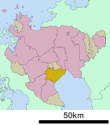
is a town
located in Kishima District
, Saga Prefecture
, Japan
.
On January 1, 2005 Shiroshi absorbed the towns of Fukudomi
and Ariake
, all from Kishima District
, to become the new and expanded town of Shiroshi.
on the southeast. Much of the land near the Ariake Sea
is reclaimed.
.
, renkon, strawberries, onions, rice
, and beef
.
. It features Japanese horseback archery, called yabusame
., December 26th - A bonfire festival where people pray for the coming year.
Towns of Japan
A town is a local administrative unit in Japan. It is a local public body along with prefecture , city , and village...
located in Kishima District
Kishima District, Saga
is a district located in Saga Prefecture, Japan.As of February 1, 2009, the district has an estimated population of 45,085 and a density of 318 persons per km²...
, Saga Prefecture
Saga Prefecture
is located in the northwest part of the island of Kyūshū, Japan. It touches both the Sea of Japan and the Ariake Sea. The western part of the prefecture is a region famous for producing ceramics and porcelain, particularly the towns of Karatsu, Imari, and Arita...
, Japan
Japan
Japan is an island nation in East Asia. Located in the Pacific Ocean, it lies to the east of the Sea of Japan, China, North Korea, South Korea and Russia, stretching from the Sea of Okhotsk in the north to the East China Sea and Taiwan in the south...
.
On January 1, 2005 Shiroshi absorbed the towns of Fukudomi
Fukudomi, Saga
is a former town in Kishima District, Saga Prefecture, Japan.On January 1, 2005 Fukudomi, along with the town of Ariake, also from Kishima District, was merged into the expanded town of Shiroishi....
and Ariake
Ariake, Saga
is a former town in Kishima District, Saga Prefecture, Japan.On January 1, 2005 Ariake, along with the town of Fukudomi, also from Kishima District, was merged into the expanded town of Shiroishi....
, all from Kishima District
Kishima District, Saga
is a district located in Saga Prefecture, Japan.As of February 1, 2009, the district has an estimated population of 45,085 and a density of 318 persons per km²...
, to become the new and expanded town of Shiroshi.
Geography
85% of the total area of Shiroishi is farmland. The town borders the Ariake SeaAriake Sea
The is a body of salt water surrounded by Fukuoka, Saga, Nagasaki, and Kumamoto Prefectures, all of which lie on the island of Kyūshū in Japan. It is the largest bay in Kyūshū. Its deepest point is only about 50 m deep, and extreme tides exceed 4 m. It is used for aquaculture, with nori...
on the southeast. Much of the land near the Ariake Sea
Ariake Sea
The is a body of salt water surrounded by Fukuoka, Saga, Nagasaki, and Kumamoto Prefectures, all of which lie on the island of Kyūshū in Japan. It is the largest bay in Kyūshū. Its deepest point is only about 50 m deep, and extreme tides exceed 4 m. It is used for aquaculture, with nori...
is reclaimed.
Climate
- Annual Mean Air Temperature: 16˚C (60.8˚F)
- Annual Mean Precipitation: about 1450 mm (57 in)
Adjoining Cities and Municipalities
- KashimaKashima, Sagais a city located in the southern part of Saga Prefecture on the island of Kyūshū, Japan.-Geography:Kashima is located about 60 kilometers southwest of Saga City. It borders the Ariake Sea to the east and Nagasaki Prefecture to the southwest...
- TakeoTakeo, Sagais a city located in Saga Prefecture on the island of Kyūshū, Japan.-Geography:Takeo is located in the western part of Saga Prefecture. It is approximately west of Saga City and approximately east of Sasebo. Takeo has a complex topography including mountains, mountain basins and riverside...
- UreshinoUreshino, Sagais a city located in the western part of Saga Prefecture on the island of Kyūshū, Japan. The city was formed on January 1, 2006 by the merger of the towns of Ureshino and Shiota...
- ŌmachiŌmachi, Sagais a town located in Kishima District, Saga Prefecture, Japan.-Geography:*Mountains: The northern part of town gradually becomes mountainous.*Rivers: Rokkaku River*Lakes: The northern, mountainous part of town is dotted with ponds....
- KōhokuKōhoku, Sagais a town located in Kishima District, Saga Prefecture, Japan. It is known as a crossroads for railways and national highways, and as such has dubbed itself "the navel of Saga".-Geography:*Mountains: The northern part of the city is gradually mountainous....
- OgiOgi, Sagais a city located in the central part of Saga on the island of Kyūshū, Japan.On March 3, 2005 Ogi District was dissolved when the old town of Ogi absorbed the towns of Ashikari, Mikatsuki and Ushizu, all from Ogi District, to become Ogi City...
History
- April 1, 1889 - The modern municipal systemMunicipalities of JapanJapan has three levels of government: national, prefectural, and municipal. The nation is divided into 47 prefectures. Each prefecture consists of numerous municipalities. There are four types of municipalities in Japan: cities, towns, villages and special wards...
is established. At this time Shiroishi consists of nine separate villages: Hashishita, Fukudomi, Fukuji, Kinkō, Kita-Ariake, Minami-Ariake, Rokkaku, Ryūō, and Suko. - April 1, 1936 - Fukuji gains town status and is renamed Shiroishi.
- April 1, 1955 - Kinkō and Ryūō merge to form Ariake.
- July 20, 1955 - Rokkaku and Suko are incorporated into Shiroishi.
- September 30, 1955 - Minami-Ariake is incorporated into Ariake.
- July 1, 1956 - Kita-Ariake is incorporated into Shiroishi.
- October 1, 1962 - Ariake gains town status.
- April 1, 1967 - Fukudomi gains town status.
- January 1, 2005 - The towns of Shiroishi, FukudomiFukudomi, Sagais a former town in Kishima District, Saga Prefecture, Japan.On January 1, 2005 Fukudomi, along with the town of Ariake, also from Kishima District, was merged into the expanded town of Shiroishi....
, and AriakeAriake, Sagais a former town in Kishima District, Saga Prefecture, Japan.On January 1, 2005 Ariake, along with the town of Fukudomi, also from Kishima District, was merged into the expanded town of Shiroishi....
are merged under the name Shiroishi.
Demographics
27.01% of the population (7,437) are 65 or older. In 2005 there were 183 births and 322 deaths, 624 immigrants and 805 emigrants, indicating a negative population growthPopulation growth
Population growth is the change in a population over time, and can be quantified as the change in the number of individuals of any species in a population using "per unit time" for measurement....
.
Agriculture
Shiroishi is a very agricultural community. Some of their agricultural products include tempeTempeh
Tempeh , or tempe , is a traditional soy product originally from Indonesia. It is made by a natural culturing and controlled fermentation process that binds soybeans into a cake form, similar to a very firm vegetarian burger patty...
, renkon, strawberries, onions, rice
Rice
Rice is the seed of the monocot plants Oryza sativa or Oryza glaberrima . As a cereal grain, it is the most important staple food for a large part of the world's human population, especially in East Asia, Southeast Asia, South Asia, the Middle East, and the West Indies...
, and beef
Beef
Beef is the culinary name for meat from bovines, especially domestic cattle. Beef can be harvested from cows, bulls, heifers or steers. It is one of the principal meats used in the cuisine of the Middle East , Australia, Argentina, Brazil, Europe and the United States, and is also important in...
.
Junior High Schools
- Shiroishi Junior High School
- Fukudomi Junior High School
- Ariake Junior High School
Elementary Schools
- Suko Elementary School
- Rokkaku Elementary School
- Shiroishi Elementary School
- Hokumei Elementary School
- Fukudomi Elementary School
- Ariake East Elementary School
- Ariake West Elementary School
- Ariake South Elementary School
Rail
- JR Kyūshū
- Nagasaki Main Line
- Hizen-ShiroishiHizen-Shiroishi Stationis a train station in Shiroishi, Kishima District, Saga Prefecture, Japan. It is operated by JR Kyushu and is on the Nagasaki Main Line.-Layout:It is an above ground station consisting of two tracks flanked by two side platforms.-Other:...
and Hizen-RyūōHizen-Ryuo Stationis a train station in Shiroishi, Kishima District, Saga Prefecture, Japan. It is operated by JR Kyushu and is on the Nagasaki Main Line.-Layout:It is an above ground station consisting of two tracks flanked by two side platforms.-Surroundings:...
- Hizen-Shiroishi
- Nagasaki Main Line
Roads
- National HighwaysNational highways of JapanJapan has a nationwide system of distinct from the expressways. The Ministry of Land, Infrastructure and Transport and other government agencies administer the national highways. Beginning in 1952, Japan classified these as Class 1 or Class 2. Class 1 highways had one- or two-digit numbers, while...
: Route 207 and Route 444. - Prefectural Roads: Saga Prefecture Route 36
Festivals
, July 13th - Floats are pulled down the main shopping district in the tradition of the Kyoto Gion Festival., October 1st - A fall festival celebrating the sea at Kaidou Shrine., October 19th - This fall festival is held at the Tsumayama, Rokkaku, Inasa, and Fukudomi shrinesJinja (Shinto)
A Shinto shrine is a structure whose main purpose is to house one or more Shinto kami....
. It features Japanese horseback archery, called yabusame
Yabusame
is a type of mounted archery in traditional Japanese archery. An archer on a running horse shoots three special "turnip-headed" arrows successively at three wooden targets....
., December 26th - A bonfire festival where people pray for the coming year.