
Shire of Trayning
Encyclopedia
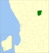
The Shire of Trayning is a Local Government Area
in the Wheatbelt region of Western Australia
, about 60 kilometres (37 mi) northwest of Merredin
and about 240 kilometres (149 mi) east of the state capital, Perth
. The Shire covers an area of 1651 square kilometres (637 sq mi), and its seat of government is the town of Trayning
.
and Kellerberrin
Road Districts. On 30 June 1911, the Korrelocking
Road Board was gazetted, covering Trayning, Wyalkatchem and parts of Mount Marshall and Dowerin
. This lasted just nine months, becoming the Ninghan Road District in March 1912. Wyalkatchem split away in 1920, and Ninghan split in 1923 and absorbed parts of Nungarin to become Kununoppin-Trayning Road District and Mount Marshall Road District.
On 1 July 1961, it became the Shire of Trayning-Kununoppin-Yelbeni following changes to the Local Government Act, and then was renamed Shire of Trayning on 10 September 1965.
Local Government Areas of Western Australia
The Australian state of Western Australia is divided into 141 local government areas...
in the Wheatbelt region of Western Australia
Western Australia
Western Australia is a state of Australia, occupying the entire western third of the Australian continent. It is bounded by the Indian Ocean to the north and west, the Great Australian Bight and Indian Ocean to the south, the Northern Territory to the north-east and South Australia to the south-east...
, about 60 kilometres (37 mi) northwest of Merredin
Merredin, Western Australia
-Economy:The agricultural land around Merredin produces 40% of Western Australia’s wheat quota. As a focal point for the region, Merredin’s local bulk handling co-operative receives and processes in excess of a million tonnes of grain every year...
and about 240 kilometres (149 mi) east of the state capital, Perth
Perth, Western Australia
Perth is the capital and largest city of the Australian state of Western Australia and the fourth most populous city in Australia. The Perth metropolitan area has an estimated population of almost 1,700,000....
. The Shire covers an area of 1651 square kilometres (637 sq mi), and its seat of government is the town of Trayning
Trayning, Western Australia
Trayning is a town located in the north-eastern Wheatbelt region of Western Australia, 236 kilometres east of the state capital, Perth, between the towns of Wyalkatchem and Nungarin. At the 2006 census, Trayning had a population of 122....
.
History
Initially, the area was split between the MeckeringShire of Cunderdin
The Shire of Cunderdin is a Local Government Area located in the Wheatbelt region of Western Australia, about west of Merredin and about east of Perth, the state capital. The Shire covers an area of and its seat of government is the town of Cunderdin....
and Kellerberrin
Shire of Kellerberrin
The Shire of Kellerberrin is a Local Government Area in the Wheatbelt region of Western Australia, about west of Merredin and about east of Perth, the state capital...
Road Districts. On 30 June 1911, the Korrelocking
Korrelocking, Western Australia
Korrelocking is a small town situated between Wyalkatchemand Trayning in the Wheatbelt region of Western Australia. At the 2006 census, Korrelocking had a population of 76....
Road Board was gazetted, covering Trayning, Wyalkatchem and parts of Mount Marshall and Dowerin
Shire of Dowerin
The Shire of Dowerin is a Local Government Area in the Wheatbelt region of Western Australia, about northeast of Perth, the state capital. The Shire covers an area of and its seat of government is the town of Dowerin.-History:...
. This lasted just nine months, becoming the Ninghan Road District in March 1912. Wyalkatchem split away in 1920, and Ninghan split in 1923 and absorbed parts of Nungarin to become Kununoppin-Trayning Road District and Mount Marshall Road District.
On 1 July 1961, it became the Shire of Trayning-Kununoppin-Yelbeni following changes to the Local Government Act, and then was renamed Shire of Trayning on 10 September 1965.
Wards
The shire has no wards, and all councillors serve 4-year terms. Previously, it was divided into 3 wards.- Trayning Ward (3 councillors)
- Kununoppin Ward (4 councillors)
- Yelbeni Ward (2 councillors)
Towns and localities
- TrayningTrayning, Western AustraliaTrayning is a town located in the north-eastern Wheatbelt region of Western Australia, 236 kilometres east of the state capital, Perth, between the towns of Wyalkatchem and Nungarin. At the 2006 census, Trayning had a population of 122....
- KununoppinKununoppinKununoppin is a small town in the Wheatbelt region of Western Australia. The town is located on the Nungarin-Wyalkatchem Road and in the Shire of Trayning local government area, north east of the state capital, Perth, Western Australia...
- YelbeniYelbeni, Western AustraliaYelbeni is small town 222 km East North East of Perth, Western Australia along the Nungaring-Wyalkatchem Road situated in the Wheatbelt Region of Western Australia. At the 2006 census, Yelbeni had a population of 118....