
Shire of Cunderdin
Encyclopedia
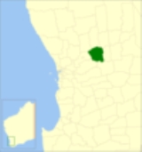
The Shire of Cunderdin is a Local Government Area
located in the Wheatbelt region of Western Australia
, about 105 kilometres (65 mi) west of Merredin
and about 155 kilometres (96 mi) east of Perth
, the state capital. The Shire covers an area of 1864 square kilometres (720 sq mi) and its seat of government is the town of Cunderdin
.
Local Government Areas of Western Australia
The Australian state of Western Australia is divided into 141 local government areas...
located in the Wheatbelt region of Western Australia
Western Australia
Western Australia is a state of Australia, occupying the entire western third of the Australian continent. It is bounded by the Indian Ocean to the north and west, the Great Australian Bight and Indian Ocean to the south, the Northern Territory to the north-east and South Australia to the south-east...
, about 105 kilometres (65 mi) west of Merredin
Merredin, Western Australia
-Economy:The agricultural land around Merredin produces 40% of Western Australia’s wheat quota. As a focal point for the region, Merredin’s local bulk handling co-operative receives and processes in excess of a million tonnes of grain every year...
and about 155 kilometres (96 mi) east of Perth
Perth, Western Australia
Perth is the capital and largest city of the Australian state of Western Australia and the fourth most populous city in Australia. The Perth metropolitan area has an estimated population of almost 1,700,000....
, the state capital. The Shire covers an area of 1864 square kilometres (720 sq mi) and its seat of government is the town of Cunderdin
Cunderdin, Western Australia
Cunderdin is a town located in the Wheatbelt region of Western Australia 156 km east of Perth, on Great Eastern Highway.- History :The first European visitor to the area was Charles Cooke Hunt, who explored the area in 1864 and recorded the name Cunderdin, from the Aboriginal name of a nearby...
.
History
On 14 December 1894, the Meckering Road District was created, changing its name to Cunderdin on 3 November 1944. On 1 July 1961, it became a Shire following the enactment of the Local Government Act 1960.Wards
All wards in the shire were abolished before the 3 May 2003 election. Prior to this, it had 8 councillors representing two wards - West Ward (3 councillors) and Central Ward (5 councillors).Towns and localities
- CunderdinCunderdin, Western AustraliaCunderdin is a town located in the Wheatbelt region of Western Australia 156 km east of Perth, on Great Eastern Highway.- History :The first European visitor to the area was Charles Cooke Hunt, who explored the area in 1864 and recorded the name Cunderdin, from the Aboriginal name of a nearby...
- MeckeringMeckering, Western AustraliaMeckering is a town 130 km east of Perth, Western Australia along the Great Eastern Highway. Meckering is located within the Shire of Cunderdin.A railway line was completed in the area in 1895 and Meckering was selected as a station site...
- Warding East
- Wyola West
- YoundeginYoundegin, Western AustraliaYoundegin is a small town 155 km east of Perth, Western Australia along the Goldfields Road situated in the Wheatbelt Region of Western Australia.The townsite of Youndegin was gazetted in 1892....
Population
| Year | Population |
|---|---|
| 1911 | 2,115 |
| 1921 | 2,183 |
| 1933 | 2,745 |
| 1947 | 2,445 |
| 1954 | 2,130 |
| 1961 | 2,014 |
| 1966 | 2,114 |
| 1971 | 1,862 |
| 1976 | 1,586 |
| 1981 | 1,630 |
| 1986 | 1,484 |
| 1991 | 1,389 |
| 1996 | 1,368 |
| 2001 | 1,374 |
| 2006 | 1,250 |