
Shire of Kellerberrin
Encyclopedia
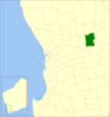
The Shire of Kellerberrin is a Local Government Area
in the Wheatbelt region of Western Australia
, about 60 kilometres (37 mi) west of Merredin
and about 200 kilometres (124 mi) east of Perth
, the state capital. The Shire covers an area of 1917 square kilometres (740 sq mi) and its seat of government is the town of Kellerberrin
.
Local Government Areas of Western Australia
The Australian state of Western Australia is divided into 141 local government areas...
in the Wheatbelt region of Western Australia
Western Australia
Western Australia is a state of Australia, occupying the entire western third of the Australian continent. It is bounded by the Indian Ocean to the north and west, the Great Australian Bight and Indian Ocean to the south, the Northern Territory to the north-east and South Australia to the south-east...
, about 60 kilometres (37 mi) west of Merredin
Merredin, Western Australia
-Economy:The agricultural land around Merredin produces 40% of Western Australia’s wheat quota. As a focal point for the region, Merredin’s local bulk handling co-operative receives and processes in excess of a million tonnes of grain every year...
and about 200 kilometres (124 mi) east of Perth
Perth, Western Australia
Perth is the capital and largest city of the Australian state of Western Australia and the fourth most populous city in Australia. The Perth metropolitan area has an estimated population of almost 1,700,000....
, the state capital. The Shire covers an area of 1917 square kilometres (740 sq mi) and its seat of government is the town of Kellerberrin
Kellerberrin, Western Australia
Kellerberrin is a town in the Wheatbelt region of Western Australia, east of Perth on the Great Eastern Highway.The railway line from Northam to Southern Cross was constructed through here in 1893-94, and this section opened for traffic in 1895. Kellerberrin was one of the original stations when...
.
History
On 24 July 1908, the Kellerberrin Road District was created, and included large parts of what is now Tammin, Wyalkatchem and Trayning. On 1 July 1961, it became the Shire of Kellerberrin after the Local Government Act 1960 was enacted.Wards
The shire has seven councillors and no wards. Prior to the elections in May 2003, there were eight councillors representing three wards - East Ward (2), Kellerberrin Ward (4) and West Ward (2).Towns and localities
- KellerberrinKellerberrin, Western AustraliaKellerberrin is a town in the Wheatbelt region of Western Australia, east of Perth on the Great Eastern Highway.The railway line from Northam to Southern Cross was constructed through here in 1893-94, and this section opened for traffic in 1895. Kellerberrin was one of the original stations when...
- BaandeeBaandee, Western AustraliaBaandee is a small town located in the Wheatbelt region of Western Australia, about halfway between the towns of Kellerberrin and Merredin on the Great Eastern Highway approximately from Perth, the state capital.-History:The town was gazetted in April 1912...
- DoodlakineDoodlakine, Western AustraliaDoodlakine is located 220 km ENE of Perth, Western Australia. It is situated within the Shire of Kellerberrin along the Great Eastern Highway. The town also contains a crossing loop for trains on the Perth to Kalgoorlie railway, and serves as a stop on the Avonlink rural train service.The area...
- Mount Caroline
Population
| Year | Population |
|---|---|
| 1921 | 1,804 |
| 1933 | 2,412 |
| 1947 | 2,076 |
| 1954 | 2,347 |
| 1961 | 2,420 |
| 1966 | 2,367 |
| 1971 | 2,132 |
| 1976 | 1,794 |
| 1981 | 1,663 |
| 1986 | 1,436 |
| 1991 | 1,326 |
| 1996 | 1,210 |
| 2001 | 1,162 |
| 2006 | 1,183 |