
Shire of Dowerin
Encyclopedia
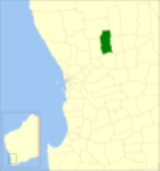
The Shire of Dowerin is a Local Government Area
in the Wheatbelt region of Western Australia
, about 160 kilometres (99 mi) northeast of Perth
, the state capital. The Shire covers an area of 1847 square kilometres (713 sq mi) and its seat of government is the town of Dowerin
.
Previously, Town Ward had 2 councillors and six wards had one councillor each: Daren, Hindmarsh, Koombekine, Manmanning, Minnivale and Ucarty.
Local Government Areas of Western Australia
The Australian state of Western Australia is divided into 141 local government areas...
in the Wheatbelt region of Western Australia
Western Australia
Western Australia is a state of Australia, occupying the entire western third of the Australian continent. It is bounded by the Indian Ocean to the north and west, the Great Australian Bight and Indian Ocean to the south, the Northern Territory to the north-east and South Australia to the south-east...
, about 160 kilometres (99 mi) northeast of Perth
Perth, Western Australia
Perth is the capital and largest city of the Australian state of Western Australia and the fourth most populous city in Australia. The Perth metropolitan area has an estimated population of almost 1,700,000....
, the state capital. The Shire covers an area of 1847 square kilometres (713 sq mi) and its seat of government is the town of Dowerin
Dowerin, Western Australia
Dowerin is a town and shire located north-east of Perth in the central Wheatbelt region of Western Australia.-History:In 1906 the government extended the railway from Goomalling to the developing Dowerin Agricultural Area and decided to develop a townsite at the terminus...
.
History
On 3 November 1911, the Dowerin Road District was gazetted. On 1 July 1961, it became a Shire following enactment of the Local Government Act 1960.Wards
As of 3 May 2003, the shire has been divided into 3 wards.- Town Ward (4 councillors)
- Rural North Ward (2 councillors)
- Rural South Ward (2 councillors)
Previously, Town Ward had 2 councillors and six wards had one councillor each: Daren, Hindmarsh, Koombekine, Manmanning, Minnivale and Ucarty.
Towns and localities
- DowerinDowerin, Western AustraliaDowerin is a town and shire located north-east of Perth in the central Wheatbelt region of Western Australia.-History:In 1906 the government extended the railway from Goomalling to the developing Dowerin Agricultural Area and decided to develop a townsite at the terminus...
- AmeryAmery, Western AustraliaAmery is a rail siding and townsite located northeast of Dowerin in the Wheatbelt region of Western Australia.-History:Amery was first known as "Ejanding" in 1910. Its name was changed to Amery in 1928, apparently because another railway siding approximately 26 km further north was to be...
- EjandingEjanding, Western AustraliaEjanding is a townsite in the central Wheatbelt, located about north-northeast of Dowerin. It was originally a siding on the Ejanding Northward railway, a line built between the town now known as Amery, and Kalannie, around 1927. Amery was originally named Ejanding in 1910, but was changed to...
- Koomberkine
- ManmanningManmanning, Western AustraliaManmanning is a small Wheatbelt town in Western Australia.The name of the town is an Indigenous Australian word of unknown meaning. The word first appeared on charts drawn in 1907 and was the Indigenous Australian name of a soak located close to the townsite....
- Minnivale
- Ucarty
Population
| Year | Population |
|---|---|
| 1921 | 1,063 |
| 1933 | 1,475 |
| 1947 | 1,152 |
| 1954 | 1,311 |
| 1961 | 1,392 |
| 1966 | 1,300 |
| 1971 | 1,071 |
| 1976 | 1,070 |
| 1981 | 998 |
| 1986 | 961 |
| 1991 | 881 |
| 1996 | 817 |
| 2001 | 782 |
| 2006 | 702 |