
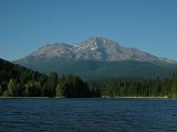
Shastina
Encyclopedia
Shastina is the highest satellite cone
of Mount Shasta
, and one of four overlapping volcanic cones which together form the most voluminous stratovolcano
in the Cascade Range
. At 12330 ft (3,758 m) , Shastina is taller than Mount Adams
and would rank as the third highest volcano in the Cascades behind Mount Rainier
and Shasta were it not nestled on the western flank of its higher neighbor. Shastina has a topographic prominence
of over 450 ft (137 m) above the saddle
connecting it with Shasta and easily exceeds the typical mountaineering
standard of 300 ft (91 m) for a peak to qualify as an independent summit, yet most lists of Cascade volcanoes omit it nonetheless. The name "Shastina" is a diminutive
of Shasta.
, but with several geological features which make it unique among other volcanoes in the Cascade Volcanic Arc
. The most prominent feature when seen from lowland viewpoints is Diller Canyon, a large cleft carved into the western flank by pyroclastic flows and since expanded by erosion. It extends from the crater rim near 12000 feet (3,657.6 m) down for over 7,000 vertical feet (2,100 m) towards the town of Weed
in the valley below, and is by far the largest such feature found on any of the Cascade volcanoes. Unseen except by mountaineers and fliers are the three small crater lake
s nestled among the cones and ridges of the summit crater, which rarely melt free of snow until late summer. Clarence King
Lake at 11755 ft (3,583 m) occupies the center of the crater, while Sisson Lake lies at 11793 ft (3,595 m) on the eastern side. Highest of all is an unnamed lake at over 11960 ft (3,645 m) on the south side of the cinder cone which forms Shastina's true summit. These lakes are the highest subaerial
lakes in the entire Cascade Range, exceeded only by the subglacial lake beneath the ice of Mount Rainier's summit crater.
Satellite cone
A parasitic cone is the cone-shaped accumulation of volcanic material not part of the central vent of a volcano. One forms by eruptions from fractures on the flank of the volcano. These fractures occur because of the flank of the volcano is unstable...
of Mount Shasta
Mount Shasta
Mount Shasta is located at the southern end of the Cascade Range in Siskiyou County, California and at is the second highest peak in the Cascades and the fifth highest in California...
, and one of four overlapping volcanic cones which together form the most voluminous stratovolcano
Stratovolcano
A stratovolcano, also known as a composite volcano, is a tall, conical volcano built up by many layers of hardened lava, tephra, pumice, and volcanic ash. Unlike shield volcanoes, stratovolcanoes are characterized by a steep profile and periodic, explosive eruptions...
in the Cascade Range
Cascade Range
The Cascade Range is a major mountain range of western North America, extending from southern British Columbia through Washington and Oregon to Northern California. It includes both non-volcanic mountains, such as the North Cascades, and the notable volcanoes known as the High Cascades...
. At 12330 ft (3,758 m) , Shastina is taller than Mount Adams
Mount Adams (Washington)
Mount Adams is a potentially activestratovolcano in the Cascade Range and the second-highest mountain in the U.S. state of Washington.Adams is a member of the Cascade Volcanic Arc, and is one of the arc's largest volcanoes,...
and would rank as the third highest volcano in the Cascades behind Mount Rainier
Mount Rainier
Mount Rainier is a massive stratovolcano located southeast of Seattle in the state of Washington, United States. It is the most topographically prominent mountain in the contiguous United States and the Cascade Volcanic Arc, with a summit elevation of . Mt. Rainier is considered one of the most...
and Shasta were it not nestled on the western flank of its higher neighbor. Shastina has a topographic prominence
Topographic prominence
In topography, prominence, also known as autonomous height, relative height, shoulder drop , or prime factor , categorizes the height of the mountain's or hill's summit by the elevation between it and the lowest contour line encircling it and no higher summit...
of over 450 ft (137 m) above the saddle
Mountain pass
A mountain pass is a route through a mountain range or over a ridge. If following the lowest possible route, a pass is locally the highest point on that route...
connecting it with Shasta and easily exceeds the typical mountaineering
Mountaineering
Mountaineering or mountain climbing is the sport, hobby or profession of hiking, skiing, and climbing mountains. While mountaineering began as attempts to reach the highest point of unclimbed mountains it has branched into specialisations that address different aspects of the mountain and consists...
standard of 300 ft (91 m) for a peak to qualify as an independent summit, yet most lists of Cascade volcanoes omit it nonetheless. The name "Shastina" is a diminutive
Diminutive
In language structure, a diminutive, or diminutive form , is a formation of a word used to convey a slight degree of the root meaning, smallness of the object or quality named, encapsulation, intimacy, or endearment...
of Shasta.
Geological features
Shastina has the general form of a smooth-sided cone truncated by a 0.5 mile (0.80467 km) diameter summit craterVolcanic crater
A volcanic crater is a circular depression in the ground caused by volcanic activity. It is typically a basin, circular in form within which occurs a vent from which magma erupts as gases, lava, and ejecta. A crater can be of large dimensions, and sometimes of great depth...
, but with several geological features which make it unique among other volcanoes in the Cascade Volcanic Arc
Cascade Volcanoes
The Cascade Volcanoes are a number of volcanoes in a volcanic arc in western North America, extending from southwestern British Columbia through Washington and Oregon to Northern California, a distance of well over 700 mi ...
. The most prominent feature when seen from lowland viewpoints is Diller Canyon, a large cleft carved into the western flank by pyroclastic flows and since expanded by erosion. It extends from the crater rim near 12000 feet (3,657.6 m) down for over 7,000 vertical feet (2,100 m) towards the town of Weed
Weed, California
Weed is a city located in Siskiyou County, California. As of the 2010 Census, the town had a total population of 2,967, down from 2,979 at the 2000 census. There are several unincorporated communities adjacent to, or just outside Weed proper. These include Edgewood, Carrick, Lake Shastina, Rancho...
in the valley below, and is by far the largest such feature found on any of the Cascade volcanoes. Unseen except by mountaineers and fliers are the three small crater lake
Crater lake
A crater lake is a lake that forms in a volcanic crater or caldera, such as a maar; less commonly and with lower association to the term a lake may form in an impact crater caused by a meteorite. Sometimes lakes which form inside calderas are called caldera lakes, but often this distinction is not...
s nestled among the cones and ridges of the summit crater, which rarely melt free of snow until late summer. Clarence King
Clarence King
Clarence R. King was an American geologist, mountaineer, and art critic. First director of the United States Geological Survey, from 1879 to 1881, King was noted for his exploration of the Sierra Nevada. He was born in Newport, Rhode Island.-Career:...
Lake at 11755 ft (3,583 m) occupies the center of the crater, while Sisson Lake lies at 11793 ft (3,595 m) on the eastern side. Highest of all is an unnamed lake at over 11960 ft (3,645 m) on the south side of the cinder cone which forms Shastina's true summit. These lakes are the highest subaerial
Subaerial
The term subaerial is mainly used in geology to describe events or structures that are located at the Earth's surface...
lakes in the entire Cascade Range, exceeded only by the subglacial lake beneath the ice of Mount Rainier's summit crater.