

Scratchbury Camp
Encyclopedia
Scratchbury Camp is the site of an Iron Age
univallate hillfort
located on Scratchbury Hill, near the village and civil parish of Norton Bavant
in Wiltshire
. The fort covers an area of 37 acres (15 ha) and occupies the summit of the hill on the edge of Salisbury Plain
, with its four-sided shape largely following the natural contours of the hill.
The Iron Age hillfort dates to around 100 BC, but contains the remains of an earlier and smaller D-shaped enclosure or camp. The age of this earlier earthwork is currently subject to debate, and the interpretation of various previous excavation records; it may be early Iron Age dating to around 250 BC, but it has also been interpreted as being Bronze Age, dating to around 2000 BC.
There are seven Tumuli located within the enclosure of the fort, which were excavated in the 19th Century by Sir Richard Colt Hoare and William Cunnington
. Finds included relics of bone, pottery, flint, brass, and amber jewellery, most of which can be seen today at the Wiltshire Heritage Museum
in Devizes
. In addition other items of interest have been found in and around the site including Roman
artefacts and neolithic
flint and jade
axe heads.
The site is listed on Wiltshire Council's Sites and Monuments Record
number ST94SW200, and is also a scheduled monument number SM10213. The fort falls within a biological Site of Special Scientific Interest
, designated as Scratchbury & Cotley Hills SSSI, which encompasses a total of 53.5 hectares (132.2 acre), being first SSSI notified in 1951.
word for the Devil
;
and bury, from the Old English word beorg, meaning a mound or hill, or sometimes a defense; although it could also be derived from burh
, meaning a fortified town or a defended site.
. The reason for their emergence in Britain, and their purpose, has been a subject of debate. It has been argued that they could have been military sites constructed in response to invasion from continental Europe, sites built by invaders, or a military reaction to social tensions caused by an increasing population and consequent pressure on agriculture. The dominant view since the 1960s has been that the increasing use of iron led to social changes in Britain. Deposits of iron ore were located in different places to the tin and copper ore necessary to make bronze, and as a result trading patterns shifted and the old elites lost their economic and social status. Power passed into the hands of a new group of people. Archaeologist Barry Cunliffe
believes that population increase still played a role and has stated "[the forts] provided defensive possibilities for the community at those times when the stress [of an increasing population] burst out into open warfare. But I wouldn't see them as having been built because there was a state of war. They would be functional as defensive strongholds when there were tensions and undoubtedly some of them were attacked and destroyed, but this was not the only, or even the most significant, factor in their construction".
s to the more accessible sides. The inner earthworks are typical of a "quarry-ditch" formation, whereby the material excavated from the inner ditch is used to create the rampart. The fortifications are best preserved on the western side of the hill where the ditch is between 5 and 8 m (16.4 and 26.2 ft) wide and up to 1 metres (3.3 ft) deep. The banks and ditches are generally uneven in height and depth, which is thought to be evidence for a 'gang dug' construction of the earthworks. Elsewhere, the enclosure is defined by a bank 3 to 6 m (9.8 to 19.7 ft) in height above the ditch bottom, the ditch being 4 to 6 m (13.1 to 19.7 ft) wide and up to 0.5 metres (1.6 ft) deep. On parts of the eastern side of the fort the ditch is absent and is replaced by a ledge of between 3 to 8 m (9.8 to 26.2 ft) wide. There are two original entrances to the fort on the eastern side, and a possible third on the northwest side.
Much of the north and west areas of the interior appear to have been densely settled, as demonstrated by the traces of approximately 100 probable structures. These survive mainly as shallow circular hollows of between 5 to 10 m (16.4 to 32.8 ft) in diameter and up to 0.6 metres (2 ft) deep. The best preserved is a rectangular platform immediately within the southern terminal of the western entrance. The location and unusual morphology suggests a special function for this structure, and it is perhaps plausible that a 'guard chamber' or sentry was positioned here.
, and was originally interpreted by Curwen to be a Neolithic
causewayed enclosure due to its interrupted nature, and the discovery at the site of jade
and flint
axes.
Subsequent excavations by W.F.Grimes in 1957 re-interpreted this feature to be an earlier Iron Age enclosure dating to approximately 250 BC, with Iron Age pottery found within the primary fill. It was therefore speculated that the visible interruptions have been made by post Medieval ploughing. Faint traces of a remnant bank survive along the north and west sections, and an adjoining ditch has a causewayed nature, and survives in short segments varying between 30 to 50 m (98.4 to 164 ft) in length. There is also evidence of a single original west facing entrance currently discernable as a 15 metres (49.2 ft) wide gap in the enclosure boundary. The straight southeastern side of the enclosure is formed by a ditch that is truncated by the main hillfort boundary, and this again has been interpreted as further evidence that the linear ditch and contiguous enclosure pre-date the main hillfort.
However, more recent aerial and photographic surveys have meant that W.F.Grimes' re-interpretation may have been in error. A detailed survey undertaken between 1994 and 1995 by the field survey teams of the Royal Commission on the Historical Monuments of England
have suggested that the feature is in fact more likely to be a Neolithic causewayed enclosure as originally interpreted by E.C.Curwen. One possible explanation for the apparent confusion in dating this feature is that Grimes may not have excavated fully to the primary fill. The surveys suggest that the feature clearly has causeways, and low winter sun photography shows that the enclosure continues beyond what was previously believed to be its eastern edge, to form a sub-circular rather than D-shaped enclosure feature. The 'crop mark' visible on aerial photographs shows a continuation of the curve to the southeast of the straight side, thus roughly completing a circle. It should be noted that this feature has also been interpreted as a possible base for a palisaded enclosure. There is also a probable link between the likely neolithic causewayed enclosure and the surrounding barrow cemetery, which would have followed later.
Whether there were distinct 2nd and 3rd Iron Age phases, or merely a re-alignment in the 2nd phase is unclear. The scarp subdividing the early fort is a possible indication of a 2nd phase, but may have been the setting out for a bank that was never utilised. In its 3rd and final phase it seems possible that the fort, having been 'laid out' to include the large barrow, was then further extended to encompass the whole of the top of the hill in order to make full defensive use of the natural slopes and resulting in the present day configuration.
in Devizes
.
Most recently Professor William Francis Grimes partially excavated the inner earthworks on the site in the 1950s. Finds included for Iron Age pottery. In 1880 two Bronze Age axes were found at the site. A Roman bronze spoon was found on the site in 1804.
Sir Richard Colt Hoare also records the discoveries of a neolithic jade axe and a ground flint axe with 'British and Roman' pottery inside the camp, as excavated by William Cunnington in 1802. The flint axe is of polished white flint, with the end re-chipped, and was found at the entrance to Scratchbury Camp. It measures 86 millimetre long, by 63 millimetre wide, and 25 millimetre high.
The hillfort also contains seven tumuli
within its boundaries, which were excavated between 1802 and 1804 by Sir Richard Colt Hoare and William Cunnington
. However, as the three-age system
had not yet been introduced, they were unable to date their finds and therefore at a disadvantage when trying to interpret them. The tumuli were re-recorded in the 1957 surveys by W.F.Grimes. Full details and descriptions from the reports and writings of Sir Richard Colt-Hoare, and William Cunnington are given in the table below:
There are several other tumuli located on the adjacent and co-joined Cotley Hill, on the crown of that hill itself is a further Bronze Age tumuli surrounded by an Iron Age enclosure.
, and within the area of Norton Bavant Chalk Downland Edge
, as described by the West Wiltshire Landscape Character Assessment. Forming part of the Southern England Chalk Formation
, the landscape is underlain by a combination of Lower, Middle and Upper Chalk supporting shallow well drained calcareous
silty soils over chalk on slopes and crests. Typically these landscapes may be described as 'dramatic', due to their local scale, visual aesthetic and undulating nature. Escarpments are often formed where layers of chalk have been compressed to form a fold, or where the chalk has been faulted, resulting in accelerated erosion along the line of the weakness.
For the Norton Bavant Chalk Downland Edge, the 'character' of this area encompasses three distinctive, steeply sloping hills (Middle Hill, Scratchbury Hill, and Cotley Hill), which form a distinct and somewhat isolated unit of Chalk Downland Edge. The hills are covered with long fields, which are predominantly arable, with occasional patches of rough remnant chalk grassland and scrub situated on the top of the hills. Many chalk grassland slopes in England show the mark of centuries of grazing by sheep, the slopes bearing a stepped or striped appearance formed by a mixture of soil creep and sheep paths, and such erosion is visible on the slopes of Scratchbury Hill. Regular patches and belts of mixed woodland populate parts of the lower slopes. Imber range perimeter paths run across the top of the hills, providing public access to the area.
, which is the largest remaining area of calcareous grassland
in north-west Europe. The local area supports a rich and diverse grassland flora and an important associated butterfly fauna, which led to it being declared a biological Site of Special Scientific Interest
in 1951. Designated as Scratchbury & Cotley Hills SSSI, the site encompasses a total of 53.5 hectares (132.2 acre).
The turf is dominated by Sheep's Fescue Festuca ovina, Red Fescue Festuca rubra
and Upright Brome Bromus erectus
. There ar also several characteristic herbs of the Wiltshire downland including for Devil's Bit Scabious Succisa pratensis
, Saw-wort Serratula tinctoria
and Chalk Milkwort Polygala calcarea
There are also many other native and site specific plants, orchids, meadow grasses, Nettles, and other flora.
Within the Hillfort, a richer, more mesotrophic grassland is present, most probably reflecting past agricultural use and improvement. There are also small areas of Hawthorn Crataegus monogyna, and Elder scrub Sambucus, particularly along the lower slopes of the downland. These provide valuable shelter for invertebrate
s on an otherwise open and exposed site.
The site is of high entomological
interest, with 29 varieties of resident breeding species of butterfly recorded. Typically horseshoe vetch Hippocrepis comosa is locally plentiful and supports both the Chalkhill Blue
Lysandra coridon and the Adonis Blue
Lysandra bellargus butterflies. Other butterfly species to be found on and around the site include for the Duke of Burgundy
Hamaeris lucina, the Grizzled Skipper
Pyrgus malvae, the Dark Green Fritillary
Argynnis aglaja and the Small Blue
Cupido minimus.
Other insect groups on the site are less well surveyed, but several rare species have been noted. These include six species of weevil Curculionoidea, eight species of plant bugs Hemiptera
and Homoptera
, and two species of Chrysomelid beetle
, Apthona herbigrada and Mantura matthewsii, both of which feed on the rock rose Helianthemum
. Day flying moths recorded include for the Wood Tiger Parasemia plantaginis and the rare Forester Moth Adscita globulariae.
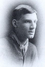 The English poet and author Siegfried Sassoon
, (1886–1967), who lived nearby at Heytesbury
House, wrote about Scratchbury Camp, subtly capturing the ambience of the Wiltshire Downs on a summers day, whilst touching on the pervasive military presence of that age and the historical timelessness of the area:
, and to the north of the village and civil parish of Norton Bavant
, in the county of Wiltshire
. The hill has a summit of 197 m (646.3 ft) AOD. Nearby to the northwest lies Middle Hill, and further northwest the hillfort of Battlesbury Camp
, on Battlesbury Hill. To the southeast lies Cotley Hill. The site and surrounding downs are easily accessible by public footpath, the Wessex Ridgeway
follows the northern ramparts of the fort, however care must be taken not to stray into the Military Firing ranges of Salisbury Plain
immediately to the northeast. Cranborne Chase and West Wiltshire Downs
Area of Outstanding Natural Beauty
lies to the south.
Iron Age
The Iron Age is the archaeological period generally occurring after the Bronze Age, marked by the prevalent use of iron. The early period of the age is characterized by the widespread use of iron or steel. The adoption of such material coincided with other changes in society, including differing...
univallate hillfort
Hill fort
A hill fort is a type of earthworks used as a fortified refuge or defended settlement, located to exploit a rise in elevation for defensive advantage. They are typically European and of the Bronze and Iron Ages. Some were used in the post-Roman period...
located on Scratchbury Hill, near the village and civil parish of Norton Bavant
Norton Bavant
Norton Bavant is a village and civil parish in Wiltshire, England.-Location:The village is southeast of the market town of Warminster, just off the A36 road to Salisbury, and at the edge of Salisbury Plain...
in Wiltshire
Wiltshire
Wiltshire is a ceremonial county in South West England. It is landlocked and borders the counties of Dorset, Somerset, Hampshire, Gloucestershire, Oxfordshire and Berkshire. It contains the unitary authority of Swindon and covers...
. The fort covers an area of 37 acres (15 ha) and occupies the summit of the hill on the edge of Salisbury Plain
Salisbury Plain
Salisbury Plain is a chalk plateau in central southern England covering . It is part of the Southern England Chalk Formation and largely lies within the county of Wiltshire, with a little in Hampshire. The plain is famous for its rich archaeology, including Stonehenge, one of England's best known...
, with its four-sided shape largely following the natural contours of the hill.
The Iron Age hillfort dates to around 100 BC, but contains the remains of an earlier and smaller D-shaped enclosure or camp. The age of this earlier earthwork is currently subject to debate, and the interpretation of various previous excavation records; it may be early Iron Age dating to around 250 BC, but it has also been interpreted as being Bronze Age, dating to around 2000 BC.
There are seven Tumuli located within the enclosure of the fort, which were excavated in the 19th Century by Sir Richard Colt Hoare and William Cunnington
William Cunnington
William Cunnington was a pioneering English antiquarian and archaeologist of the late eighteenth and early nineteenth century. His work centred on excavating the barrows of Salisbury Plain. The first recorded excavations at Stonehenge were done by William Cunnington & Richard Colt Hoare in 1798...
. Finds included relics of bone, pottery, flint, brass, and amber jewellery, most of which can be seen today at the Wiltshire Heritage Museum
Wiltshire Heritage Museum
The Wiltshire Heritage Museum, formerly known as Devizes Museum, is a museum, archive and library and art gallery in Devizes, Wiltshire, England. The museum was established and is still run by, the Wiltshire Archaeological and Natural History Society , a registered charity founded in 1853. After...
in Devizes
Devizes
Devizes is a market town and civil parish in Wiltshire, England. The town is about southeast of Chippenham and about east of Trowbridge.Devizes serves as a centre for banks, solicitors and shops, with a large open market place where a market is held once a week...
. In addition other items of interest have been found in and around the site including Roman
Ancient Rome
Ancient Rome was a thriving civilization that grew on the Italian Peninsula as early as the 8th century BC. Located along the Mediterranean Sea and centered on the city of Rome, it expanded to one of the largest empires in the ancient world....
artefacts and neolithic
Neolithic
The Neolithic Age, Era, or Period, or New Stone Age, was a period in the development of human technology, beginning about 9500 BC in some parts of the Middle East, and later in other parts of the world. It is traditionally considered as the last part of the Stone Age...
flint and jade
Jade
Jade is an ornamental stone.The term jade is applied to two different metamorphic rocks that are made up of different silicate minerals:...
axe heads.
The site is listed on Wiltshire Council's Sites and Monuments Record
Sites and Monuments Record
Each County or Unitary Authority in the United Kingdom maintains a Sites and Monuments Record or SMR, consisting of a list of known archaeological sites. Many SMRs are now developing into much broader Historic Environment Records , including information on historic buildings and designed landscapes...
number ST94SW200, and is also a scheduled monument number SM10213. The fort falls within a biological Site of Special Scientific Interest
Site of Special Scientific Interest
A Site of Special Scientific Interest is a conservation designation denoting a protected area in the United Kingdom. SSSIs are the basic building block of site-based nature conservation legislation and most other legal nature/geological conservation designations in Great Britain are based upon...
, designated as Scratchbury & Cotley Hills SSSI, which encompasses a total of 53.5 hectares (132.2 acre), being first SSSI notified in 1951.
Etymology
The name of the hill is derived from the words scratch, an old West CountryWest Country
The West Country is an informal term for the area of south western England roughly corresponding to the modern South West England government region. It is often defined to encompass the historic counties of Cornwall, Devon, Dorset and Somerset and the City of Bristol, while the counties of...
word for the Devil
Devil
The Devil is believed in many religions and cultures to be a powerful, supernatural entity that is the personification of evil and the enemy of God and humankind. The nature of the role varies greatly...
;
and bury, from the Old English word beorg, meaning a mound or hill, or sometimes a defense; although it could also be derived from burh
Burh
A Burh is an Old English name for a fortified town or other defended site, sometimes centred upon a hill fort though always intended as a place of permanent settlement, its origin was in military defence; "it represented only a stage, though a vitally important one, in the evolution of the...
, meaning a fortified town or a defended site.
Background
Hill forts developed in the Late Bronze and Early Iron Age, roughly the start of the first millennium BC1st millennium BC
The 1st millennium BC encompasses the Iron Age and sees the rise of many successive empires, and spanned from 1000 BC to 1 BC.The Neo-Assyrian Empire, followed by the Achaemenids. In Greece, Classical Antiquity begins with the colonization of Magna Graecia and peaks with the rise of Hellenism. The...
. The reason for their emergence in Britain, and their purpose, has been a subject of debate. It has been argued that they could have been military sites constructed in response to invasion from continental Europe, sites built by invaders, or a military reaction to social tensions caused by an increasing population and consequent pressure on agriculture. The dominant view since the 1960s has been that the increasing use of iron led to social changes in Britain. Deposits of iron ore were located in different places to the tin and copper ore necessary to make bronze, and as a result trading patterns shifted and the old elites lost their economic and social status. Power passed into the hands of a new group of people. Archaeologist Barry Cunliffe
Barry Cunliffe
Sir Barrington Windsor Cunliffe, CBE, known professionally as Barry Cunliffe is a former Professor of European Archaeology at the University of Oxford, a position held from 1972 to 2007...
believes that population increase still played a role and has stated "[the forts] provided defensive possibilities for the community at those times when the stress [of an increasing population] burst out into open warfare. But I wouldn't see them as having been built because there was a state of war. They would be functional as defensive strongholds when there were tensions and undoubtedly some of them were attacked and destroyed, but this was not the only, or even the most significant, factor in their construction".
Iron Age Hillfort
The steeply contoured sides of Scratchbury Hill form natural defenses to the north, west and southwestern sides, and in part to a small area of the eastern flank. Elsewhere on the hill the contours are less steep and afford easier access, with the southeastern boundary merging into the adjacent Cotley Hill with only a small change in level. The Iron Age fortifications at Scratchbury Camp comprise of a single large ditch and rampart to the most steeply contoured flanks, with some secondary counterscarpCounterscarp
A scarp and a counterscarp are the inner and outer sides of a ditch used in fortifications. In permanent fortifications the scarp and counterscarp may be encased in stone...
s to the more accessible sides. The inner earthworks are typical of a "quarry-ditch" formation, whereby the material excavated from the inner ditch is used to create the rampart. The fortifications are best preserved on the western side of the hill where the ditch is between 5 and 8 m (16.4 and 26.2 ft) wide and up to 1 metres (3.3 ft) deep. The banks and ditches are generally uneven in height and depth, which is thought to be evidence for a 'gang dug' construction of the earthworks. Elsewhere, the enclosure is defined by a bank 3 to 6 m (9.8 to 19.7 ft) in height above the ditch bottom, the ditch being 4 to 6 m (13.1 to 19.7 ft) wide and up to 0.5 metres (1.6 ft) deep. On parts of the eastern side of the fort the ditch is absent and is replaced by a ledge of between 3 to 8 m (9.8 to 26.2 ft) wide. There are two original entrances to the fort on the eastern side, and a possible third on the northwest side.
Much of the north and west areas of the interior appear to have been densely settled, as demonstrated by the traces of approximately 100 probable structures. These survive mainly as shallow circular hollows of between 5 to 10 m (16.4 to 32.8 ft) in diameter and up to 0.6 metres (2 ft) deep. The best preserved is a rectangular platform immediately within the southern terminal of the western entrance. The location and unusual morphology suggests a special function for this structure, and it is perhaps plausible that a 'guard chamber' or sentry was positioned here.
Earlier Enclosure
Within the centre of the hillfort lies the remains of an earlier and smaller D-shaped inner earthwork enclosure of circa 3.5 hectares (8.6 acre), and excavated by E.C.Curwen in 1930. Today, all that really remains of this enclosure is one well defined lynchet of approximately 0.5 metres (1.6 ft) high along the southern section. This feature bears a resemblance to a similar such enclosure at Yarnbury CastleYarnbury Castle
Yarnbury Castle is a 9.1 hectare biological Site of Special Scientific Interest in Wiltshire, England, notified in 1951.-Source:* -External links:*...
, and was originally interpreted by Curwen to be a Neolithic
Neolithic
The Neolithic Age, Era, or Period, or New Stone Age, was a period in the development of human technology, beginning about 9500 BC in some parts of the Middle East, and later in other parts of the world. It is traditionally considered as the last part of the Stone Age...
causewayed enclosure due to its interrupted nature, and the discovery at the site of jade
Jade
Jade is an ornamental stone.The term jade is applied to two different metamorphic rocks that are made up of different silicate minerals:...
and flint
Flint
Flint is a hard, sedimentary cryptocrystalline form of the mineral quartz, categorized as a variety of chert. It occurs chiefly as nodules and masses in sedimentary rocks, such as chalks and limestones. Inside the nodule, flint is usually dark grey, black, green, white, or brown in colour, and...
axes.
Subsequent excavations by W.F.Grimes in 1957 re-interpreted this feature to be an earlier Iron Age enclosure dating to approximately 250 BC, with Iron Age pottery found within the primary fill. It was therefore speculated that the visible interruptions have been made by post Medieval ploughing. Faint traces of a remnant bank survive along the north and west sections, and an adjoining ditch has a causewayed nature, and survives in short segments varying between 30 to 50 m (98.4 to 164 ft) in length. There is also evidence of a single original west facing entrance currently discernable as a 15 metres (49.2 ft) wide gap in the enclosure boundary. The straight southeastern side of the enclosure is formed by a ditch that is truncated by the main hillfort boundary, and this again has been interpreted as further evidence that the linear ditch and contiguous enclosure pre-date the main hillfort.
However, more recent aerial and photographic surveys have meant that W.F.Grimes' re-interpretation may have been in error. A detailed survey undertaken between 1994 and 1995 by the field survey teams of the Royal Commission on the Historical Monuments of England
Royal Commission on the Historical Monuments of England
The Royal Commission on the Historical Monuments of England was the body formerly responsible for documenting the records of English historical monuments. It was merged with English Heritage on 1 April 1999....
have suggested that the feature is in fact more likely to be a Neolithic causewayed enclosure as originally interpreted by E.C.Curwen. One possible explanation for the apparent confusion in dating this feature is that Grimes may not have excavated fully to the primary fill. The surveys suggest that the feature clearly has causeways, and low winter sun photography shows that the enclosure continues beyond what was previously believed to be its eastern edge, to form a sub-circular rather than D-shaped enclosure feature. The 'crop mark' visible on aerial photographs shows a continuation of the curve to the southeast of the straight side, thus roughly completing a circle. It should be noted that this feature has also been interpreted as a possible base for a palisaded enclosure. There is also a probable link between the likely neolithic causewayed enclosure and the surrounding barrow cemetery, which would have followed later.
Later Features
There is also a Romano-British or later ditch, running east to west, which turns south sharply at the southwest corner of the hillfort, and which partly overlies the earlier Iron Age earthworks. The main ramparts appear to have been built in the 1st century BC.Construction Phases
The archaeological evidence suggests that Scratchbury Camp was built in at least two but perhaps three phases. The 1st phase is the defined by the curvilinear portion of the interior 'D'-shaped enclosure.Whether there were distinct 2nd and 3rd Iron Age phases, or merely a re-alignment in the 2nd phase is unclear. The scarp subdividing the early fort is a possible indication of a 2nd phase, but may have been the setting out for a bank that was never utilised. In its 3rd and final phase it seems possible that the fort, having been 'laid out' to include the large barrow, was then further extended to encompass the whole of the top of the hill in order to make full defensive use of the natural slopes and resulting in the present day configuration.
Archaeology
Excavations at the site have revealed many items from Neolithic, Bronze Age, Iron Age and Romano British periods. Most of the various finds discovered are now preserved at the Wiltshire Heritage MuseumWiltshire Heritage Museum
The Wiltshire Heritage Museum, formerly known as Devizes Museum, is a museum, archive and library and art gallery in Devizes, Wiltshire, England. The museum was established and is still run by, the Wiltshire Archaeological and Natural History Society , a registered charity founded in 1853. After...
in Devizes
Devizes
Devizes is a market town and civil parish in Wiltshire, England. The town is about southeast of Chippenham and about east of Trowbridge.Devizes serves as a centre for banks, solicitors and shops, with a large open market place where a market is held once a week...
.
Most recently Professor William Francis Grimes partially excavated the inner earthworks on the site in the 1950s. Finds included for Iron Age pottery. In 1880 two Bronze Age axes were found at the site. A Roman bronze spoon was found on the site in 1804.
Sir Richard Colt Hoare also records the discoveries of a neolithic jade axe and a ground flint axe with 'British and Roman' pottery inside the camp, as excavated by William Cunnington in 1802. The flint axe is of polished white flint, with the end re-chipped, and was found at the entrance to Scratchbury Camp. It measures 86 millimetre long, by 63 millimetre wide, and 25 millimetre high.
The hillfort also contains seven tumuli
Tumulus
A tumulus is a mound of earth and stones raised over a grave or graves. Tumuli are also known as barrows, burial mounds, Hügelgrab or kurgans, and can be found throughout much of the world. A tumulus composed largely or entirely of stones is usually referred to as a cairn...
within its boundaries, which were excavated between 1802 and 1804 by Sir Richard Colt Hoare and William Cunnington
William Cunnington
William Cunnington was a pioneering English antiquarian and archaeologist of the late eighteenth and early nineteenth century. His work centred on excavating the barrows of Salisbury Plain. The first recorded excavations at Stonehenge were done by William Cunnington & Richard Colt Hoare in 1798...
. However, as the three-age system
Three-age system
The three-age system in archaeology and physical anthropology is the periodization of human prehistory into three consecutive time periods, named for their respective tool-making technologies:* The Stone Age* The Bronze Age* The Iron Age-Origin:...
had not yet been introduced, they were unable to date their finds and therefore at a disadvantage when trying to interpret them. The tumuli were re-recorded in the 1957 surveys by W.F.Grimes. Full details and descriptions from the reports and writings of Sir Richard Colt-Hoare, and William Cunnington are given in the table below:
| Wiltshire Heritage Museum ref name | R.Colt-Hoare ref no. | Type | Diameter | Height | Images | Description |
|---|---|---|---|---|---|---|
| Norton Bavant Tumuli G1 | 1 | Bowl Barrow | 81 ft (24.7 m) | 3 ft (0.9144 m) | Contained an interment of burned bones, and with which was deposited a small lance head, or dagger of brass, a large amber Amber Amber is fossilized tree resin , which has been appreciated for its color and natural beauty since Neolithic times. Amber is used as an ingredient in perfumes, as a healing agent in folk medicine, and as jewelry. There are five classes of amber, defined on the basis of their chemical constituents... ring, a piece of brass two to three inches long and resembling a screw, another piece of twisted brass, and more than fifty amber beads (identified as belonging to amber class 2 or 3). Also located close to this was a pile of ashes intermixed with fragments of burned bones. |
|
| Norton Bavant Tumuli G2 | 2 | Bowl barrow | 45 ft (13.7 m) | 3.5 ft (1.1 m) | Found to contain burned bones and some articles fashioned from bone, two of which were about 2 inch long, and flat, and the third was either a pin or arrow head, neatly polished to a very sharp point. | |
| Norton Bavant Tumuli G3 | 3 | Bowl barrow | 36 ft (11 m) | 2 ft (0.6096 m) | No recorded finds. | |
| Norton Bavant Tumuli G4 | 7 | Bowl barrow | 100 ft (30.5 m) | 10 ft (3 m) | The largest tumuli on the site and very conspicuous from the road below. It contained finds of fragments of antlers, boar's teeth, charcoal and large numbers of burnt stones, but no internment. The large quantity of stones that had undergone the action of fire seems to indicate that this was a sepulchral barrow, in which the ceremony of cremation was performed. | |
| Norton Bavant Tumuli G4a | 6 | Bowl barrow | unknown | unknown | No recorded finds. | |
| Norton Bavant Tumuli G4b | 4 | Bowl barrow | 15 ft (4.6 m) | 0.25 ft (0.0762 m) | No recorded finds. | |
| Norton Bavant Tumuli G4c | 5 | Bowl barrow | 30 ft (9.1 m) | 1.5 ft (0.4572 m) | Found to contain a few burned bones at some distance from the centre. |
There are several other tumuli located on the adjacent and co-joined Cotley Hill, on the crown of that hill itself is a further Bronze Age tumuli surrounded by an Iron Age enclosure.
Geography
Scratchbury is located on the edge of the chalk plateau of Salisbury PlainSalisbury Plain
Salisbury Plain is a chalk plateau in central southern England covering . It is part of the Southern England Chalk Formation and largely lies within the county of Wiltshire, with a little in Hampshire. The plain is famous for its rich archaeology, including Stonehenge, one of England's best known...
, and within the area of Norton Bavant Chalk Downland Edge
Downland
A downland is an area of open chalk hills. This term is especially used to describe the chalk countryside in southern England. Areas of downland are often referred to as Downs....
, as described by the West Wiltshire Landscape Character Assessment. Forming part of the Southern England Chalk Formation
Southern England Chalk Formation
The Chalk Formation of Southern England is a system of chalk downland in the south of England. The formation is perhaps best known for Salisbury Plain, the location of Stonehenge, the Isle of Wight and the twin ridgeways of the North Downs and South Downs....
, the landscape is underlain by a combination of Lower, Middle and Upper Chalk supporting shallow well drained calcareous
Calcareous
Calcareous is an adjective meaning mostly or partly composed of calcium carbonate, in other words, containing lime or being chalky. The term is used in a wide variety of scientific disciplines.-In zoology:...
silty soils over chalk on slopes and crests. Typically these landscapes may be described as 'dramatic', due to their local scale, visual aesthetic and undulating nature. Escarpments are often formed where layers of chalk have been compressed to form a fold, or where the chalk has been faulted, resulting in accelerated erosion along the line of the weakness.
For the Norton Bavant Chalk Downland Edge, the 'character' of this area encompasses three distinctive, steeply sloping hills (Middle Hill, Scratchbury Hill, and Cotley Hill), which form a distinct and somewhat isolated unit of Chalk Downland Edge. The hills are covered with long fields, which are predominantly arable, with occasional patches of rough remnant chalk grassland and scrub situated on the top of the hills. Many chalk grassland slopes in England show the mark of centuries of grazing by sheep, the slopes bearing a stepped or striped appearance formed by a mixture of soil creep and sheep paths, and such erosion is visible on the slopes of Scratchbury Hill. Regular patches and belts of mixed woodland populate parts of the lower slopes. Imber range perimeter paths run across the top of the hills, providing public access to the area.
Ecology
Scratchbury is located in an area of unimproved grassland on the edge of Salisbury PlainSalisbury Plain
Salisbury Plain is a chalk plateau in central southern England covering . It is part of the Southern England Chalk Formation and largely lies within the county of Wiltshire, with a little in Hampshire. The plain is famous for its rich archaeology, including Stonehenge, one of England's best known...
, which is the largest remaining area of calcareous grassland
Calcareous grassland
Calcareous grassland is an ecosystem associated with thin basic soil, such as that on chalk and limestone downland. Plants on calcareous grassland are typically short and hardy, and include grasses and herbs such as clover...
in north-west Europe. The local area supports a rich and diverse grassland flora and an important associated butterfly fauna, which led to it being declared a biological Site of Special Scientific Interest
Site of Special Scientific Interest
A Site of Special Scientific Interest is a conservation designation denoting a protected area in the United Kingdom. SSSIs are the basic building block of site-based nature conservation legislation and most other legal nature/geological conservation designations in Great Britain are based upon...
in 1951. Designated as Scratchbury & Cotley Hills SSSI, the site encompasses a total of 53.5 hectares (132.2 acre).
The turf is dominated by Sheep's Fescue Festuca ovina, Red Fescue Festuca rubra
Festuca rubra
Festuca rubra is a species of grass known by the common name red fescue. It is found worldwide and can tolerate many habitats and climates; it generally needs full sun to thrive...
and Upright Brome Bromus erectus
Bromus
Bromus is a large genus of the grass family . Estimates in the scientific literature of the number of species have ranged from 100 to 400, but plant taxonomists currently recognize around 160–170 species...
. There ar also several characteristic herbs of the Wiltshire downland including for Devil's Bit Scabious Succisa pratensis
Succisa pratensis
Succisa pratensis Moench, also known as Devil's-bit Scabious, is a flowering plant of the genus Succisa in the family Dipsacaceae. It differs from other similar species in that it has 4 lobed flowers, whereas Small Scabious and Field scabious have 5 lobes and hence it has been placed in a separate...
, Saw-wort Serratula tinctoria
Serratula tinctoria
Serratula tinctoria, commonly known as Saw-wort, is a species in the genus Serratula. It is a native of Europe. It grows in moist soil, full sun to part shade, and grows up to one meter tall....
and Chalk Milkwort Polygala calcarea
Polygala
Polygala is a genus of about 500 species of flowering plants belonging to the family Polygalaceae, commonly known as milkwort or snakeroot...
There are also many other native and site specific plants, orchids, meadow grasses, Nettles, and other flora.
Within the Hillfort, a richer, more mesotrophic grassland is present, most probably reflecting past agricultural use and improvement. There are also small areas of Hawthorn Crataegus monogyna, and Elder scrub Sambucus, particularly along the lower slopes of the downland. These provide valuable shelter for invertebrate
Invertebrate
An invertebrate is an animal without a backbone. The group includes 97% of all animal species – all animals except those in the chordate subphylum Vertebrata .Invertebrates form a paraphyletic group...
s on an otherwise open and exposed site.
The site is of high entomological
Entomology
Entomology is the scientific study of insects, a branch of arthropodology...
interest, with 29 varieties of resident breeding species of butterfly recorded. Typically horseshoe vetch Hippocrepis comosa is locally plentiful and supports both the Chalkhill Blue
Chalkhill Blue
The Chalkhill Blue is a butterfly in the family Lycaenidae.Males have pale silvery-blue wings with black and white border . Females are dark brown, also with the black and white borders...
Lysandra coridon and the Adonis Blue
Adonis Blue
The Adonis Blue is a butterfly in the family Lycaenidae.-Habitat:The preferred habitat of the adonis blue is calcareous grasslands with hot and dry conditions.-Species decline:...
Lysandra bellargus butterflies. Other butterfly species to be found on and around the site include for the Duke of Burgundy
Duke of Burgundy
Duke of Burgundy was a title borne by the rulers of the Duchy of Burgundy, a small portion of traditional lands of Burgundians west of river Saône which in 843 was allotted to Charles the Bald's kingdom of West Franks...
Hamaeris lucina, the Grizzled Skipper
Grizzled Skipper
The Grizzled Skipper Pyrgus malvae is a butterfly of the Hesperiidae family.-Appearance, behaviour and distribution:With its characteristic chequered black and white pattern this butterfly is quite distinctive although old, faded individuals can be mistaken for the Dingy Skipper or the Sideridis...
Pyrgus malvae, the Dark Green Fritillary
Dark Green Fritillary
The Dark Green Fritillary is a butterfly of the Nymphalidae family.The insect has a wide range in the Palearctic ecozone - Europe, Morocco, Iran , Siberia, Central Asia, China, Korea and Japan.-Subspecies:...
Argynnis aglaja and the Small Blue
Small Blue
The Small Blue is a butterfly in the family Lycaenidae.It is found in Europe, Asia Minor, Transcaucasia, Tian-Shan, West Siberia, Central Siberia, South Siberia, Russian Far East, Amur, Mongolia, Magadan and Kamchatka....
Cupido minimus.
Other insect groups on the site are less well surveyed, but several rare species have been noted. These include six species of weevil Curculionoidea, eight species of plant bugs Hemiptera
Hemiptera
Hemiptera is an order of insects most often known as the true bugs , comprising around 50,000–80,000 species of cicadas, aphids, planthoppers, leafhoppers, shield bugs, and others...
and Homoptera
Homoptera
Homoptera is a deprecated suborder of order Hemiptera; recent morphological studies and DNA analysis strongly suggests that the order is paraphyletic. It was therefore split into the suborders Sternorrhyncha, Auchenorrhyncha, and Coleorrhyncha....
, and two species of Chrysomelid beetle
Leaf beetle
Beetles in the family Chrysomelidae are commonly known as leaf beetles. This is a family of over 35,000 species in more than 2,500 genera, one of the largest and most commonly encountered of all beetle families....
, Apthona herbigrada and Mantura matthewsii, both of which feed on the rock rose Helianthemum
Helianthemum
Helianthemum , known as rock rose, sunroses, or rushrose, is a genus of about 110 species of evergreen or semi-evergreen subshrubs in the family Cistaceae...
. Day flying moths recorded include for the Wood Tiger Parasemia plantaginis and the rare Forester Moth Adscita globulariae.
Poetry
Siegfried Sassoon
Siegfried Loraine Sassoon CBE MC was an English poet, author and soldier. Decorated for bravery on the Western Front, he became one of the leading poets of the First World War. His poetry both described the horrors of the trenches, and satirised the patriotic pretensions of those who, in Sassoon's...
, (1886–1967), who lived nearby at Heytesbury
Heytesbury
Heytesbury is a village in Wiltshire, England, in the Wylye Valley, about three miles south of Warminster.-History:...
House, wrote about Scratchbury Camp, subtly capturing the ambience of the Wiltshire Downs on a summers day, whilst touching on the pervasive military presence of that age and the historical timelessness of the area:
Location
The site is located at , to the east of the town of WarminsterWarminster
Warminster is a town in western Wiltshire, England, by-passed by the A36, and near Frome and Westbury. It has a population of about 17,000. The River Were runs through the town and can be seen running through the middle of the town park. The Minster Church of St Denys sits on the River Were...
, and to the north of the village and civil parish of Norton Bavant
Norton Bavant
Norton Bavant is a village and civil parish in Wiltshire, England.-Location:The village is southeast of the market town of Warminster, just off the A36 road to Salisbury, and at the edge of Salisbury Plain...
, in the county of Wiltshire
Wiltshire
Wiltshire is a ceremonial county in South West England. It is landlocked and borders the counties of Dorset, Somerset, Hampshire, Gloucestershire, Oxfordshire and Berkshire. It contains the unitary authority of Swindon and covers...
. The hill has a summit of 197 m (646.3 ft) AOD. Nearby to the northwest lies Middle Hill, and further northwest the hillfort of Battlesbury Camp
Battlesbury Camp
Battlesbury Camp is the site of an Iron Age bivallate hillfort on Battlesbury Hill in Wiltshire in South West England. Excavations and surveys at the site have uncovered various finds and archaeological data.-Background:...
, on Battlesbury Hill. To the southeast lies Cotley Hill. The site and surrounding downs are easily accessible by public footpath, the Wessex Ridgeway
Wessex Ridgeway
The Wessex Ridgeway is a long distance footpath in England. It runs from Marlborough in Wiltshire to Lyme Regis in Dorset via the edge of Salisbury Plain and Cranborne Chase. The footpath was opened in 1994...
follows the northern ramparts of the fort, however care must be taken not to stray into the Military Firing ranges of Salisbury Plain
Salisbury Plain
Salisbury Plain is a chalk plateau in central southern England covering . It is part of the Southern England Chalk Formation and largely lies within the county of Wiltshire, with a little in Hampshire. The plain is famous for its rich archaeology, including Stonehenge, one of England's best known...
immediately to the northeast. Cranborne Chase and West Wiltshire Downs
Cranborne Chase and West Wiltshire Downs
The Cranborne Chase and West Wiltshire Downs Area of Outstanding Natural Beauty covers of Dorset, Hampshire, Somerset and Wiltshire. It is the sixth largest AONB in the country....
Area of Outstanding Natural Beauty
Area of Outstanding Natural Beauty
An Area of Outstanding Natural Beauty is an area of countryside considered to have significant landscape value in England, Wales or Northern Ireland, that has been specially designated by the Countryside Agency on behalf of the United Kingdom government; the Countryside Council for Wales on...
lies to the south.
Further reading
- http://www.wiltshireheritagecollections.org.uk/wiltshirestourheadsites.asp?page=hitlist&textPrefix=scratchbury&textPrefix=&submitButton=Search Wiltshire Heritage Museum records for Scratchbury Camp and Tumuli.
- http://makinghistory.sal.org.uk/ajax.php?id=53&st=15_a_1&p=0 Photograph of Scratchbury Camp finds, from Society of Antiquaries website.
- http://www.pastscape.org.uk/hob.aspx?hob_id=211396&sort=4&search=all&criteria=scratchbury&rational=q&recordsperpage=10 English Heritage Pastscape page for Scratchbury Camp. (Monument number: 211396)
- http://www.pastscape.org.uk/hob.aspx?hob_id=211401&sort=4&search=all&criteria=scratchbury&rational=q&recordsperpage=10 English Heritage Pastscape page for the Scratchbury Camp barrow group (Monument number 211401)
- http://www.visitwiltshire.co.uk/dbimgs/walk%208.pdf Wiltshire Walks no.8: Norton Bavant and Scratchbury Hill (5.3 km/ 3.25 miles, 1 hour, Moderate)