

Scott and Seringapatam Reefs
Encyclopedia
Scott and Seringapatam Reefs is a group of atoll
-like reefs in the Timor Sea
more than 300 km northwest of Cape Leveque
, Western Australia
, on the edge of the continental shelf
. There are three or four separate reef structures, depending on whether Scott Reef Central is counted separately. The group is just one of a number of reef formations off the northwest coast of Australia
and belongs to Western Australia
. Further to the northeast are Ashmore and Cartier Islands
, and to the southwest are the Rowley Shoals
.
400 to 500 m below. Much of the reaf area dries at low tide, but besides Sandy Islet of Scott Reef South, there are only a few rocks and sandbanks above the high water mark.
is a major LNG project currently in development by Woodside Petroleum
, which includes the Torosa gas field, located underneath Scott Reef South and Scott Reef North.
Atoll
An atoll is a coral island that encircles a lagoon partially or completely.- Usage :The word atoll comes from the Dhivehi word atholhu OED...
-like reefs in the Timor Sea
Timor Sea
The Timor Sea is a relatively shallow sea bounded to the north by the island of Timor, to the east by the Arafura Sea, to the south by Australia and to the west by the Indian Ocean....
more than 300 km northwest of Cape Leveque
Cape Leveque
Cape Leveque is the northernmost tip of the Dampier Peninsula in the Kimberley region of Western Australia. Cape Leveque is 240 km north of Broome, and is remote with few facilities. Nevertheless, the Cape's sandy beaches are attracting an increasing number of visitors.A 13-metre-tall...
, Western Australia
Western Australia
Western Australia is a state of Australia, occupying the entire western third of the Australian continent. It is bounded by the Indian Ocean to the north and west, the Great Australian Bight and Indian Ocean to the south, the Northern Territory to the north-east and South Australia to the south-east...
, on the edge of the continental shelf
Continental shelf
The continental shelf is the extended perimeter of each continent and associated coastal plain. Much of the shelf was exposed during glacial periods, but is now submerged under relatively shallow seas and gulfs, and was similarly submerged during other interglacial periods. The continental margin,...
. There are three or four separate reef structures, depending on whether Scott Reef Central is counted separately. The group is just one of a number of reef formations off the northwest coast of Australia
Australia
Australia , officially the Commonwealth of Australia, is a country in the Southern Hemisphere comprising the mainland of the Australian continent, the island of Tasmania, and numerous smaller islands in the Indian and Pacific Oceans. It is the world's sixth-largest country by total area...
and belongs to Western Australia
Western Australia
Western Australia is a state of Australia, occupying the entire western third of the Australian continent. It is bounded by the Indian Ocean to the north and west, the Great Australian Bight and Indian Ocean to the south, the Northern Territory to the north-east and South Australia to the south-east...
. Further to the northeast are Ashmore and Cartier Islands
Ashmore and Cartier Islands
The Territory of the Ashmore and Cartier Islands is an external territory of Australia consisting of two groups of small low-lying uninhabited tropical islands in the Indian Ocean situated on the edge of the continental shelf north-west of Australia and south of the Indonesian island of...
, and to the southwest are the Rowley Shoals
Rowley Shoals
The Rowley Shoals is a group of three atoll-like coral reefs south of the Timor Sea, about 260 km west of Broome on the northwestern Australian coast, centered around , on the edge of one of the widest continental shelves in the world. Each atoll covers an area of around 80 to 90 km² within the rim...
.
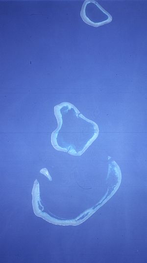
Location and Description
Each of the three reefs rises steeply from the seabedSeabed
The seabed is the bottom of the ocean.- Ocean structure :Most of the oceans have a common structure, created by common physical phenomena, mainly from tectonic movement, and sediment from various sources...
400 to 500 m below. Much of the reaf area dries at low tide, but besides Sandy Islet of Scott Reef South, there are only a few rocks and sandbanks above the high water mark.
- Scott Reef South (also Horseshoe Reef or South Reef) is a large crescent-shaped formation that has a rare and unusual double reef crest. Its lagoon, has depths of over 24 m throughout the greater portion. The reef with its lagoon covers an area of 144 km².
- Scott Reef Central, because of its proximity occasionally subsumed within Scott Reef South, lies off West Hook (the western extremity of the crescent of Scott Reef South), with Sandy Islet at 14°03′S 121°46′E (690 meters north-south, up to 110 meters wide, with an area of 0.05 km²). This reef falls dry to the extent of 0.8 to 1.6 km from the islet. There is a conspicuous tower on the islet and also a boulder with a height 2.4 m near its northern end. A detached reef, which dries 0.6 m, lies 2.4 km northeast of Sandy Islet. The passage between Scott Reef South and Scott Reef Central is only 33 m deep, much less than the passages between the other reefs (366 m between Scott Reef South and Scott Reef North).
- Scott Reef North consists of a large, approximately circular-shaped, reef lying 23 km southwest of Seringapatam Reef. The reef is composed of a narrow reef-crest that is backed by broad reef flats — much of which becomes exposed at low tide — and a deep central lagoon that is connected to the open sea by two delta-like channels. The reef with its lagoon covers an area of 106 km².
- Seringapatam Reef is located at 13°40′S 122°05′E, 23 km north of Scott Reef North. This reef is named after the Battle of SeringapatamSrirangapatnaSrirangapatna is a town in Mandya district of the Indian state of Karnataka...
, the historical last and decisive battleFourth Anglo-Mysore WarThe Fourth Anglo-Mysore War was a war in South India between the Sultanate of Mysore and the British East India Company under the Earl of Mornington....
fought between Tipu SultanTipu SultanTipu Sultan , also known as the Tiger of Mysore, was the de facto ruler of the Kingdom of Mysore. He was the son of Hyder Ali, at that time an officer in the Mysorean army, and his second wife, Fatima or Fakhr-un-Nissa...
and the British RajBritish RajBritish Raj was the British rule in the Indian subcontinent between 1858 and 1947; The term can also refer to the period of dominion...
forces in Southern IndiaIndiaIndia , officially the Republic of India , is a country in South Asia. It is the seventh-largest country by geographical area, the second-most populous country with over 1.2 billion people, and the most populous democracy in the world...
. It is a small circular-shaped reef. Its narrow reef rim encloses a relatively deep lagoon. Much of the reef becomes exposed at low tide. There are large boulders around its edges, with a few sandbanks, which rise about 1.8 m above the water, on the west side. Seringapatam Reef covers an area of 55 km² (including the central lagoon).
Browse Basin LNG Development
Browse LNGBrowse LNG
The Browse LNG is a $30 billion liquefied natural gas plant project proposed for construction at James Price Point, North of Broome on the Dampier Peninsula, Western Australia. The plant is being built by a joint partnership including Woodside Petroleum, Chevron Corporation, Royal Dutch Shell, BP,...
is a major LNG project currently in development by Woodside Petroleum
Woodside Petroleum
Woodside Petroleum Limited is an Australian petroleum exploration and production company. It is a public company listed on the Australian Securities Exchange and has its headquarters in Perth, Western Australia.-History:...
, which includes the Torosa gas field, located underneath Scott Reef South and Scott Reef North.
External links
Further reading
- Berry, P.F. Ed. (1986) Faunal surveys of the Rowley Shoals, Scott Reef, and Seringapatam Reef, North-western Australia Perth, W.A. : Western Australian Museum, Records of the Western Australian Museum. Supplement, 0313-122X ; no. 25. ISBN 0730903400