
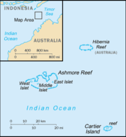
Ashmore and Cartier Islands
Encyclopedia

States and territories of Australia
The Commonwealth of Australia is a union of six states and various territories. The Australian mainland is made up of five states and three territories, with the sixth state of Tasmania being made up of islands. In addition there are six island territories, known as external territories, and a...
of Australia
Australia
Australia , officially the Commonwealth of Australia, is a country in the Southern Hemisphere comprising the mainland of the Australian continent, the island of Tasmania, and numerous smaller islands in the Indian and Pacific Oceans. It is the world's sixth-largest country by total area...
consisting of two groups of small low-lying uninhabited tropical islands in the Indian Ocean situated on the edge of the continental shelf
Continental shelf
The continental shelf is the extended perimeter of each continent and associated coastal plain. Much of the shelf was exposed during glacial periods, but is now submerged under relatively shallow seas and gulfs, and was similarly submerged during other interglacial periods. The continental margin,...
north-west of Australia
Australia
Australia , officially the Commonwealth of Australia, is a country in the Southern Hemisphere comprising the mainland of the Australian continent, the island of Tasmania, and numerous smaller islands in the Indian and Pacific Oceans. It is the world's sixth-largest country by total area...
and south of the Indonesia
Indonesia
Indonesia , officially the Republic of Indonesia , is a country in Southeast Asia and Oceania. Indonesia is an archipelago comprising approximately 13,000 islands. It has 33 provinces with over 238 million people, and is the world's fourth most populous country. Indonesia is a republic, with an...
n island of Rote
Rote Island
right|thumb|300px|Satellite photo of RotiRote Island is an island of Indonesia, part of the East Nusa Tenggara province of the Lesser Sunda Islands. It has an area of . It lies northeast of the Australian coast and northeast of the Ashmore and Cartier Islands. The island is situated to the...
.
Geography
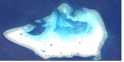
The territory includes Ashmore Reef (West, Middle, and EastEast Island (Ashmore and Cartier Islands)
East Island is one of three islets on Ashmore Reef. It is located at 12º15'S 123º05'E, about midway between Australia and Timor. It is often referred to as East Islet, a name that is used, for example, in The World Factbook; the islet's gazetted name is, however, East Island.It has an area of...
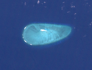
Islets) and Cartier Island
Cartier Islands
Cartier Island is an uninhabited and unvegetated sand cay in a platform reef in the Timor Sea north of Australia and south of Indonesia. It is located at 12°31'S 123°33'E, on the edge of the Sahul Shelf, about 300 kilometres off the north west coast of Western Australia, 200 kilometres south of the...
(70 km east) with, a total area of 199.45 km² (77 sq mi) within the reef
Reef
In nautical terminology, a reef is a rock, sandbar, or other feature lying beneath the surface of the water ....
s and including the lagoons, and 114,400 m² of dry land. While they have a total of 74.1 km (46 mi) of shoreline, measured along the outer edge of the reef, there are no ports or harbors, only offshore anchorage.
Nearby Hibernia Reef, 42 km (26 mi) Northeast of Ashmore Reef, is not part of the territory, but belongs to Western Australia. It has no permanently dry land area, although large parts of the reef become exposed during low tide.
Cartier Island Marine Reserve includes the entire sand cay of Cartier Island, the reef surrounding it, the ocean for a 7.2 km (4 mi) radius around the island, and 1000 m (3,280.8 ft) below the seafloor. It was proclaimed in 2000.
- Ashmore Reef 155.4 km² (60 sq mi) area within reef (including lagoon)
- West Islet, 51,200 m² land area;
- Middle Islet, 21,200 m² land area;
- East Islet, 25,000 m² land area;
- Cartier Reef (44.03 km² area within reef (including lagoon)
- Cartier Island, 17,000 m² land area;
There is an automatic weather station on West Islet.
Government
The territory is administered from Canberra by the Attorney-General's DepartmentAttorney-General's Department
An Attorney-General's Department is a government department in certain countries.*Attorney-General's Department *Attorney-General's Department...
(before 29 November 2007 administration was carried out by the Department of Transport and Regional Services). The FIPS-10 date code is AT; the territory is bundled along with Australia in ISO 3166
ISO 3166
ISO 3166 is a standard published by the International Organization for Standardization . It defines codes for the names of countries, dependent territories, special areas of geographical interest, and their principal subdivisions . The official name of the standard is Codes for the representation...
. Defence is the responsibility of Australia, with periodic visits by the Royal Australian Navy
Royal Australian Navy
The Royal Australian Navy is the naval branch of the Australian Defence Force. Following the Federation of Australia in 1901, the ships and resources of the separate colonial navies were integrated into a national force: the Commonwealth Naval Forces...
, Royal Australian Air Force
Royal Australian Air Force
The Royal Australian Air Force is the air force branch of the Australian Defence Force. The RAAF was formed in March 1921. It continues the traditions of the Australian Flying Corps , which was formed on 22 October 1912. The RAAF has taken part in many of the 20th century's major conflicts...
and Australian Customs and Border Protection Service. The islands are visited by seasonal caretakers.
Ashmore Reef is called Pulau Pasir by Indonesians, and considered part of Rote Ndao Regency
Rote Ndao Regency
Rote Ndao Regency is a regency in East Nusa Tenggara province of Indonesia, consisting primarily of the island of Rote, situated south-west of the western tip of West Timor. Established in 2002 formerly part of Kupang Regency, the regency has its seat in Baa. The population is 119.711 in 2010...
of East Nusa Tenggara
East Nusa Tenggara
East Nusa Tenggara is a province of Indonesia, located in the eastern portion of the Lesser Sunda Islands, including West Timor. The provincial capital is Kupang, located on West Timor...
province.
In the Rote Island
Rote Island
right|thumb|300px|Satellite photo of RotiRote Island is an island of Indonesia, part of the East Nusa Tenggara province of the Lesser Sunda Islands. It has an area of . It lies northeast of the Australian coast and northeast of the Ashmore and Cartier Islands. The island is situated to the...
language, it is called Nusa Solokaek. Both names have the meaning Sand Island.
On 21 October 2002 the nature reserve was recognised as a wetland of international importance when it was designated Ramsar Site 1220 under the Ramsar Convention on Wetlands
Ramsar Convention
The Ramsar Convention is an international treaty for the conservation and sustainable utilization of wetlands, i.e., to stem the progressive encroachment on and loss of wetlands now and in the future, recognizing the fundamental ecological functions of wetlands and their economic, cultural,...
.
Ecology and environment
Biodiversity
Biodiversity is the degree of variation of life forms within a given ecosystem, biome, or an entire planet. Biodiversity is a measure of the health of ecosystems. Biodiversity is in part a function of climate. In terrestrial habitats, tropical regions are typically rich whereas polar regions...
value as it is in the flow of the Indonesian Throughflow
Indonesian throughflow
The Indonesian throughflow is important to global climate since it provides a low-latitude pathway for warm, fresh water to move from the Pacific to the Indian Ocean and this serves as the upper branch of the Pacific-Indian overturning circulation global heat conveyor belt...
ocean current from the Pacific Ocean through the Malay archipelago
Malay Archipelago
The Malay Archipelago refers to the archipelago between mainland Southeastern Asia and Australia. The name was derived from the anachronistic concept of a Malay race....
to the Indian Ocean. It is also in a surface current west from the Arafura Sea
Arafura Sea
The Arafura Sea lies west of the Pacific Ocean overlying the continental shelf between Australia and New Guinea.-Geography:The Arafura Sea is bordered by Torres Strait and through that the Coral Sea to the east, the Gulf of Carpentaria to the south, the Timor Sea to the west and the Banda and Ceram...
and Timor Sea
Timor Sea
The Timor Sea is a relatively shallow sea bounded to the north by the island of Timor, to the east by the Arafura Sea, to the south by Australia and to the west by the Indian Ocean....
.
The Reserve comprises several marine habitats, including seagrass meadows, intertidal sand flats, coral reef flats, and lagoons, and supports an important and diverse range of species, including 14 species of sea snakes, a population of Dugong
Dugong
The dugong is a large marine mammal which, together with the manatees, is one of four living species of the order Sirenia. It is the only living representative of the once-diverse family Dugongidae; its closest modern relative, Steller's sea cow , was hunted to extinction in the 18th century...
that may be genetically distinct, a diverse marine invertebrate fauna, and many endemic species, especially of sea snakes and molluscs. There are feeding and nesting sites for Loggerhead, Hawksbill
Hawksbill turtle
The hawksbill sea turtle is a critically endangered sea turtle belonging to the family Cheloniidae. It is the only extant species in its genus. The species has a worldwide distribution, with Atlantic and Pacific subspecies. E. imbricata imbricata is the Atlantic subspecies, while E...
and Green Turtles. It is classified as an Important Bird Area
Important Bird Area
An Important Bird Area is an area recognized as being globally important habitat for the conservation of bird populations. Currently there are about 10,000 IBAs worldwide. The program was developed and sites are identified by BirdLife International...
and has 50,000 breeding pairs of various kinds of seabird
Seabird
Seabirds are birds that have adapted to life within the marine environment. While seabirds vary greatly in lifestyle, behaviour and physiology, they often exhibit striking convergent evolution, as the same environmental problems and feeding niches have resulted in similar adaptations...
s. A high abundance and diversity of sea cucumber
Sea cucumber
Sea cucumbers are echinoderms from the class Holothuroidea.They are marine animals with a leathery skin and an elongated body containing a single, branched gonad. Sea cucumbers are found on the sea floor worldwide. There are a number of holothurian species and genera, many of which are targeted...
s, over-exploited on other reefs in the region, is present, with 45 species recorded.
A memorandum of understanding between the Australian and Indonesian governments allows Indonesian fishermen access to their traditional fishing grounds within the region, subject to limits.
Economy and migration
There is no economic activity in the Territory. As Ashmore Reef is the closest point of Australian territory to Indonesia, it was a popular target for people smugglers transporting asylum seekers to Australia despite its only wellWater well
A water well is an excavation or structure created in the ground by digging, driving, boring or drilling to access groundwater in underground aquifers. The well water is drawn by an electric submersible pump, a trash pump, a vertical turbine pump, a handpump or a mechanical pump...
s being infected with cholera
Cholera
Cholera is an infection of the small intestine that is caused by the bacterium Vibrio cholerae. The main symptoms are profuse watery diarrhea and vomiting. Transmission occurs primarily by drinking or eating water or food that has been contaminated by the diarrhea of an infected person or the feces...
or contaminated and undrinkable. Once they had landed on Ashmore, asylum seekers could claim to have entered Australian territory and request to be processed as refugees. The use of Ashmore for this purpose created great notoriety during late 2001, when refugee arrivals became a major political issue in Australia. As Australia was not the country of first asylum for these "boat people
Boat people
Boat people is a term that usually refers to refugees, illegal immigrants or asylum seekers who emigrate in numbers in boats that are sometimes old and crudely made...
", the Australian Government did not consider it had a responsibility to accept them.
A number of things were done to discourage the practice such as attempting to have the people smugglers arrested in Indonesia; the so-called Pacific Solution
Pacific Solution
The Pacific Solution was the name given to the Australian government policy of transporting asylum seekers to detention camps on small island nations in the Pacific Ocean, rather than allowing them to land on the Australian mainland...
of processing them in third countries; the boarding and forced turnaround of the boats by Australian military forces, and finally excising Ashmore and many other small islands from the Australian migration zone
Australian migration zone
The Australian migration zone refers to the parts of Australian territory where a non citizen must hold a visa to legally enter and remain. It includes all states and mainland territories, plus some external territories, at the mean low water mark....
. Two boatloads of asylum seekers were each detained for several days in the lagoon at Ashmore after failed attempts by the Royal Australian Navy
Royal Australian Navy
The Royal Australian Navy is the naval branch of the Australian Defence Force. Following the Federation of Australia in 1901, the ships and resources of the separate colonial navies were integrated into a national force: the Commonwealth Naval Forces...
to turn them back to Indonesia in October 2001.
External links
- Geoscience Australia—Ashmore and Cartier Islands
- Department of the Environment and Heritage—Ashmore Reef National Nature Reserve
- Department of the Environment and Heritage—Cartier Island Marine Reserve
- First on list of Australian islands
- "Ashmore Reef Belongs to Indonesia," posted on East Timor Action Network. http://www.etan.org/et2003/january/05-11/06ashmorn.htm
- "Ashmore Islands are member of ARABOSAI" http://www.arabosai.org/en/members.asp