
Saxon Switzerland National Park
Encyclopedia
The Saxon Switzerland National Park , is a National Park
in the German
Free State of Saxony
near the capital city of Dresden
. It covers two areas of 93.5 km² (36.1 mi²) in the heart of the German part of the Elbe Sandstone Mountains
which is called the Saxon Switzerland
.
The National Park is not far away from the Bohemian Switzerland National Park in the Czech Republic
.
and is cultivated by humans in many places. Some smaller towns and villages like Bad Schandau
or Königstein
in the district of Sächsische Schweiz
are part of this region.
The core area of the National Park has a quiescent area of 40% and is covered almost completely by forest. The status of National Park, which grants the highest natural protection in Germany, was established in 1990. It lies – in two geographically separate areas – within the district of Sächsische Schweiz-Osterzgebirge.
landscape. The highest peak of the National Park is at 556 metres (1,814 feet) above sea level but only in short distance to the valley of the Elbe river
at 110 to 120 metres (360 to 390 feet). It offers several different habitats and microclimate
zones due to its strong vertical division. The National Park still hosts some forms of forest without human intervention, which is an exception in central Europe. The special forms of mountain forest and gorge forest are endangered in Europe generally. Because of the saboulus soil and the fissures many places in that area are dryer than normally in the temperate zone
and offers rough conditions. This makes this area so special.
and the Polenz valley
. In the west it is bordered by Wehlen
and Lohmen, in the north by Lohmen and Hohnstein, in the east by Hohnstein and Goßdorf
and in the south by Porschdorf
, Rathen
and Wehlen. The municipality of Waitzdorf lies entirely within the western region. Important peaks are the Lilienstein (415 m), the Bastei (305 m), the Hockstein and the Brand (317 m). The Grünbach and the associated lake of Amselsee
and the Polenz are the only waterbodies of note.
rocks, the Großer Winterberg
mountain, the Großer Zschand
valley and the hinterland of Saxon Switzerland (Hinterer Sächsischen Schweiz). To the west it is bordered by Bad Schandau
and Altendorf
and to the north by Altendorf, Ottendorf
and Hinterhermsdorf. To the east and south it is bordered by the Bohemian Switzerland National Park. From Schmilka to Bad Schandau the Elbe
forms the southern boundary of this region. Important peaks are the Großer Winterberg (556 m), the Kuhstall
(337 m) and the Raumberg (459 m). The Kirnitzsch
is the only waterbody of note.
network and is some 45 minutes away from Dresden (by Dresden S-Bahn
).
National park
A national park is a reserve of natural, semi-natural, or developed land that a sovereign state declares or owns. Although individual nations designate their own national parks differently A national park is a reserve of natural, semi-natural, or developed land that a sovereign state declares or...
in the German
Germany
Germany , officially the Federal Republic of Germany , is a federal parliamentary republic in Europe. The country consists of 16 states while the capital and largest city is Berlin. Germany covers an area of 357,021 km2 and has a largely temperate seasonal climate...
Free State of Saxony
Saxony
The Free State of Saxony is a landlocked state of Germany, contingent with Brandenburg, Saxony Anhalt, Thuringia, Bavaria, the Czech Republic and Poland. It is the tenth-largest German state in area, with of Germany's sixteen states....
near the capital city of Dresden
Dresden
Dresden is the capital city of the Free State of Saxony in Germany. It is situated in a valley on the River Elbe, near the Czech border. The Dresden conurbation is part of the Saxon Triangle metropolitan area....
. It covers two areas of 93.5 km² (36.1 mi²) in the heart of the German part of the Elbe Sandstone Mountains
Elbe Sandstone Mountains
The Elbe Sandstone Mountains, also called the Elbe sandstone highlands is a mountain range straddling the border between the state of Saxony in southeastern Germany and the North Bohemian region of the Czech Republic, with about three-quarters of the area lying on the German side...
which is called the Saxon Switzerland
Saxon Switzerland
Saxon Switzerland is a hilly climbing area and national park around the Elbe valley south-east of Dresden in Saxony, Germany. Together with the Bohemian Switzerland in the Czech Republic it forms the Elbe Sandstone Mountains....
.
The National Park is not far away from the Bohemian Switzerland National Park in the Czech Republic
Czech Republic
The Czech Republic is a landlocked country in Central Europe. The country is bordered by Poland to the northeast, Slovakia to the east, Austria to the south, and Germany to the west and northwest....
.
Location
The National Park is the centre of a natural area of almost 710 km² (274 mi²). This region is called Saxon SwitzerlandSaxon Switzerland
Saxon Switzerland is a hilly climbing area and national park around the Elbe valley south-east of Dresden in Saxony, Germany. Together with the Bohemian Switzerland in the Czech Republic it forms the Elbe Sandstone Mountains....
and is cultivated by humans in many places. Some smaller towns and villages like Bad Schandau
Bad Schandau
Bad Schandau is a spa town in Germany, in the south of the Free State of Saxony and the district of Sächsische Schweiz-Osterzgebirge. It is situated on the right bank of the Elbe, at the mouth of the little valley of the Kirnitzsch.-Geography:...
or Königstein
Königstein (Sächsische Schweiz)
Königstein is a town in the Free State of Saxony in Germany. Königstein lies in the Sächsische Schweiz-Osterzgebirge District and has a population of 2,898 as of 2005. Near Königstein is the Festung Königstein fortress.- Geography :...
in the district of Sächsische Schweiz
Sächsische Schweiz
The Sächsische Schweiz is a former district in the south of the Free State of Saxony, Germany. Neighboring districts were Weißeritzkreis, the district-free city Dresden and the districts Kamenz and Bautzen. To the south it bordered the Czech Republic.- History :The district was created in 1994...
are part of this region.
The core area of the National Park has a quiescent area of 40% and is covered almost completely by forest. The status of National Park, which grants the highest natural protection in Germany, was established in 1990. It lies – in two geographically separate areas – within the district of Sächsische Schweiz-Osterzgebirge.
Landscape
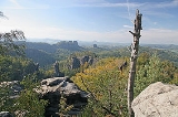
The Saxon Switzerland is an intensively fissured and rocky canyonCanyon
A canyon or gorge is a deep ravine between cliffs often carved from the landscape by a river. Rivers have a natural tendency to reach a baseline elevation, which is the same elevation as the body of water it will eventually drain into. This forms a canyon. Most canyons were formed by a process of...
landscape. The highest peak of the National Park is at 556 metres (1,814 feet) above sea level but only in short distance to the valley of the Elbe river
Elbe
The Elbe is one of the major rivers of Central Europe. It rises in the Krkonoše Mountains of the northwestern Czech Republic before traversing much of Bohemia , then Germany and flowing into the North Sea at Cuxhaven, 110 km northwest of Hamburg...
at 110 to 120 metres (360 to 390 feet). It offers several different habitats and microclimate
Microclimate
A microclimate is a local atmospheric zone where the climate differs from the surrounding area. The term may refer to areas as small as a few square feet or as large as many square miles...
zones due to its strong vertical division. The National Park still hosts some forms of forest without human intervention, which is an exception in central Europe. The special forms of mountain forest and gorge forest are endangered in Europe generally. Because of the saboulus soil and the fissures many places in that area are dryer than normally in the temperate zone
Temperate
In geography, temperate or tepid latitudes of the globe lie between the tropics and the polar circles. The changes in these regions between summer and winter are generally relatively moderate, rather than extreme hot or cold...
and offers rough conditions. This makes this area so special.
Western region
This region includes the Bastei area, the LiliensteinLilienstein
Lilienstein is a mountain of Saxony, southeastern Germany and site of a former Bohemian castle....
and the Polenz valley
Polenz (river)
The Polenz is the right-hand, smaller headstream of the Lachsbach in the German state of Saxony. Its lower course flows through the western Elbe Sandstone Mountains in a canyon-like valley.- Geography :...
. In the west it is bordered by Wehlen
Stadt Wehlen
Stadt Wehlen is a town in the Sächsische Schweiz-Osterzgebirge district, in Saxony, Germany. It is situated on the western edge of Saxon Switzerland, on the right bank of the Elbe, 6 km east of Pirna, and 23 km southeast of Dresden .-Municipality subdivisions:Wehlen includes the...
and Lohmen, in the north by Lohmen and Hohnstein, in the east by Hohnstein and Goßdorf
Gosdorf
Gosdorf is a municipality in the district of Radkersburg in Styria, Austria....
and in the south by Porschdorf
Porschdorf
Porschdorf is a municipality in the Sächsische Schweiz-Osterzgebirge district, in Saxony, Germany.- References :...
, Rathen
Rathen
Rathen is a village in the Elbe Sandstone Mountains, in Saxony, Germany, about 35 km southeast of Dresden on the Elbe River. Rathen has between 400 and 500 inhabitants....
and Wehlen. The municipality of Waitzdorf lies entirely within the western region. Important peaks are the Lilienstein (415 m), the Bastei (305 m), the Hockstein and the Brand (317 m). The Grünbach and the associated lake of Amselsee
Amselsee
The Amselsee is a small reservoir in the spa town of Rathen in Saxon Switzerland. It is located in the Free State of Saxony in Eastern Germany.- Reservoir :...
and the Polenz are the only waterbodies of note.
Eastern region
The eastern region includes the area of the SchrammsteineSchrammsteine
The Schrammsteine are a long, strung-out, very jagged group of rocks in the Elbe Sandstone Mountains located east of Bad Schandau in Saxon Switzerland in East Germany. To the north they are bordered by the Kirnitzsch valley, to the south by the Elbe valley and to the east by the Affensteine rocks....
rocks, the Großer Winterberg
Großer Winterberg
Großer Winterberg is a mountain of Saxony, southeastern Germany....
mountain, the Großer Zschand
Großer Zschand
The Großer Zschand is the longest dry valley in Saxon Switzerland and runs for about 6 km from the Neumann Mill in the Kirnitzsch valley to the Roßmaulwiese meadown in Bohemian Switzerland...
valley and the hinterland of Saxon Switzerland (Hinterer Sächsischen Schweiz). To the west it is bordered by Bad Schandau
Bad Schandau
Bad Schandau is a spa town in Germany, in the south of the Free State of Saxony and the district of Sächsische Schweiz-Osterzgebirge. It is situated on the right bank of the Elbe, at the mouth of the little valley of the Kirnitzsch.-Geography:...
and Altendorf
Kirnitzschtal
Kirnitzschtal is a municipality in the Sächsische Schweiz-Osterzgebirge district, in Saxony, Germany.-Geography:The town is divided into 5 parishes and has its administrative seat in Lichtenhain:*Altendorf*Mittelndorf*Lichtenhain...
and to the north by Altendorf, Ottendorf
Kirnitzschtal
Kirnitzschtal is a municipality in the Sächsische Schweiz-Osterzgebirge district, in Saxony, Germany.-Geography:The town is divided into 5 parishes and has its administrative seat in Lichtenhain:*Altendorf*Mittelndorf*Lichtenhain...
and Hinterhermsdorf. To the east and south it is bordered by the Bohemian Switzerland National Park. From Schmilka to Bad Schandau the Elbe
Elbe
The Elbe is one of the major rivers of Central Europe. It rises in the Krkonoše Mountains of the northwestern Czech Republic before traversing much of Bohemia , then Germany and flowing into the North Sea at Cuxhaven, 110 km northwest of Hamburg...
forms the southern boundary of this region. Important peaks are the Großer Winterberg (556 m), the Kuhstall
Kuhstall (Saxon Switzerland)
The Kuhstall is the second largest natural arch in the Elbe Sandstone Mountains after the Prebischtor. It is located on the Neuer Wildenstein, a 337 m high rock outcrop in the hinterland of Saxon Switzerland, south of the Lichtenhain Waterfall and above the Kirnitzsch valley. It is crowned by the...
(337 m) and the Raumberg (459 m). The Kirnitzsch
Kirnitzsch
The Kirnitzsch, in Bohemia also called the Kirnischt , is a right tributary of the River Elbe, which passes through the Czech Republic and the German Free State of Saxony.- Geography :...
is the only waterbody of note.
Tourism and recreation
The National Parks is, in some cases, in conflict with tourism and recreation. One objective is to raise the inviolate area to 75%, which means limiting the areas of hiking and climbing. Today there are some 400 km (248.5 mi) of hiking paths, 49.9 km (31 mi) of biking paths, and 755 climbing locations with around 12,600 possibilities of climbing routes. The National Park is part of a larger region that serves as a recreation area close to Dresden. Bad Schandau has a station in the EuroCityEuroCity
EuroCity, abbreviated EC, denotes an international train service within the European inter-city rail network. In contrast to trains with the "IC" label, "EC" trains are international trains that meet certain criteria. The EuroCity label replaces the older Trans Europ Express name for...
network and is some 45 minutes away from Dresden (by Dresden S-Bahn
Dresden S-Bahn
The Dresden S-Bahn provides commuter train services in Dresden and the surrounding area. It was established in 1973 and comprises three lines...
).
Information posts
- National Park Headquarters
- National Park Centre in Bad Schandau
- National Park Office in Bad Schandau
- Information posts
- Schweizerhaus on the Bastei
- Amselfall mountain hut
- Log cabin on the Brand
- Eishaus on the Großer Winterberg
- Armoury in the Großer Zschand
- Haus Beize and Waldhusche in Hinterhermsdorf