

Sathyamangalam
Encyclopedia
Sathyamangalam or Sathy is a small city and taluk in Erode district
in the India
n state
of Tamil Nadu
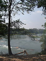
. It lies on both banks of the Bhavani River
, a tributary of the Kaveri in the foothills of the Western Ghats
. Sathyamangalam was formerly part of Coimbatore District
, but became part of Erode District
when the district was constituted in 1979.
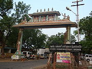
The Bannari Amman Temple
, dedicated to the goddess Bannari Mariamman, is located in Bannari
, 12 km from Sathyamangalam town. The temple draws huge crowds during the annual festival and throughout the year from various cities and states.
 A portion of the Sathyamangalam forests was declared as sanctuary in 2008.
Sathyamangalam is also the name of a Reserve Forest under the Wildlife Protection Act, 1973. It is contiguous with the Biligirirangan Temple Wildlife Sanctuary
to the north in neighbouring Chamarajanagar
District of Karnataka
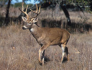
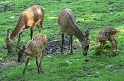
, and together forms a vital corridor for faunal movements, mainly elephants. Elephant movements in this corridor were the subject of one of the first studies on the Asian Elephant by the Indian elephant scientist R. Sukumar in early 1980s. The Sathyamangalam elephants were also the subject of Indian elephant expert Vivek Menon's book Tusker: The Story of the Asian Elephant.
The forests were also the home of the cold-blooded Indian bandit Koose Muniswamy Veerapan, who made a living exploiting ivory
and sandalwood
from the forests and selling them on the black market.
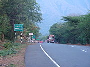
A major National highway NH 209 connecting Coimbatore
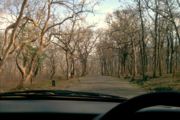
to Mysore via Sathyamangalam passes through the forests. This route is best for vehicles from Coimbatore, Erode bound for Bangalore as it has lesser traffic when compared to NH 47 (via Salem). But one must be sure about the driving skills required for a hilly terrain because it has 27 hairpin bends, some of which are highly dangerous.
The neighbouring place called Dasappagouden pudur (D.G.Pudur) which is 5 km from Sathy. The place famous for Textiles, Handloom saree weaving (all varieties of silks like kanchipuram, kora, sieko, tusser etc.,) also otherwise known as Little Bombay
 Sathyamangalam is a class-III town and also the headquarters for Sathyamangalam Taluk in Erode District
. The town was upgraded as a third grade Municipality from the status of Town Panchayat on 17.1.1970, as per G.O.Ms.No. 58 RDLS Dept. dated 12.1.70, and subsequently raised as a second grade Municipality on 1.4.77 as per G.O.Ms.No. 642 RDLA Dept. dated 15.4.77. It functions as a First Grade Municipality as per G.O.Ms.No. 855, MAWS Dept., Dated 22.5.98. The Municipality includes Sathyamangalam, Varadhampalayam, Kottuveerampalayam and Rangasamudram Revenue Villages. Its area is 29.24 km2, making it the second largest Municipality in Tamil Nadu
by area. The population, according to the 2001 census, is 33,748.
, which extends towards the east from the Nilgiri mountains. It is located at a distance of 7 km from the ghats in Sathyamangalam Taluk of Erode district
. The town lies close to the border of the adjoining Karnataka State. The nearby Bhavanisagar Dam, a picnic spot, and Bannari Amman Temple
, a centre of pilgrimage
, both attract people and tourists all the year round. There is also a heavy movement of people to Karnataka State, especially to Mysore and Kollegal, through this town.
The town is situated at a distance of 65 km.from Erode
. The headquarters of Erode District is linked with State Highway 15. The Coimbatore Mysore National Highway (NH 209) passes through this town. The nearest Railway Station is Mettupalayam in Coimbatore District, at a distance of 43 km. The Erode
Railway Junction serves as an out agency for Sathyamangalam. The town is also linked with Gobichettipalayam
, Bhavani Sagar, Mettupalayam and Bhavani
Town with District roads, and links the towns of Chamarajanagar
and Mysore in neighbouring Karnataka State, through National Highway Roads. The nearest airport is located at Coimbatore
, 68 km, away.
Registration of births and deaths, control of epidemics, maintenance of maternity and child health care, licensure of dangerous and offensive trades, and monitoring of water chlorination are carried out by the Health staff.
Proper disposal of garbage is carried out systematically to the Compost Yard by proper vehicles.
One municipal burial ground and one slaughterhouse are maintained.
Sathyamangalam is a medium-sized town with an agricultural linter land on all sides. It is one of the Taluk headquarters in Erode District and also an urban center located near the state boundaries of Tamil Nadu and Karnataka. It is one of the very old settlements of Tamil Nadu. The town has developed on both sides of Bhavani River and along the highways. The rate of urban growth of Sathyamangalam is very low, because the Northern side of this Municipality is surrounded by reserved forests. Poor industrial activities are also one of the reasons for slow growth rate of urban development. The major commercial activity is concentrated in the middle of the town. Most of the shops are located along Sathy-Gobi road and Sathy-Bannari road. The daily market and weekly shandy are located at Sathy-Athani road. The bus stand is also located in the east of the town along Sathy-Gobi road. Bannariamman Sugarcane Factory and Bannariamman Engineering and Kamadane Arts College operate at distance of 6 km., from this town.
Sathyamangalam Municipality's area in 29.24 km, comprising four revenue villages. Only 10.46% of the municipal area is developed as urban area and the remaining 89.54% remains undeveloped agricultural land. Much land is available for development, but the opportunity for development in the near future is slight due to financial weakness among the public.
It is well connected by buses from nearby towns and cities.
, Coimbatore
and Mettupalayam in Tamil Nadu and Chamarajanagar
in Karnataka.
international airport, which is 70 km by road.
since 2010 and Sathyamanagalam assembly was removed and merged with Bhavanisagar assembly constituency in 2010 .
Sathyamanagalam assembly constituency was part of the Gobichettipalayam constituency
until 2010 .
The last Member of Parliament (MP) of Gobichettipalayam Lok sabha constituency was "Mr.E.V.K.S.Elangovan (INC)" from 2004-2009.
Erode District
Erode District is a western district of the state of Tamil Nadu, India, with Erode as its headquarters. Until the year 1996, Erode district was called as Periyar District....
in the India
India
India , officially the Republic of India , is a country in South Asia. It is the seventh-largest country by geographical area, the second-most populous country with over 1.2 billion people, and the most populous democracy in the world...
n state
States and territories of India
India is a federal union of states comprising twenty-eight states and seven union territories. The states and territories are further subdivided into districts and so on.-List of states and territories:...
of Tamil Nadu
Tamil Nadu
Tamil Nadu is one of the 28 states of India. Its capital and largest city is Chennai. Tamil Nadu lies in the southernmost part of the Indian Peninsula and is bordered by the union territory of Pondicherry, and the states of Kerala, Karnataka, and Andhra Pradesh...
. It lies on both banks of the Bhavani River
Bhavani River
The Bhavani is the second largest river in Tamil Nadu, South India and a major tributary of the Kaveri River, the longest river in Tamil Nadu.-Description:...
, a tributary of the Kaveri in the foothills of the Western Ghats
Western Ghats
The Western Ghats, Western Ghauts or the Sahyādri is a mountain range along the western side of India. It runs north to south along the western edge of the Deccan Plateau, and separates the plateau from a narrow coastal plain along the Arabian Sea. The Western Ghats block rainfall to the Deccan...
. Sathyamangalam was formerly part of Coimbatore District
Coimbatore District
Coimbatore District is one of the more affluent and industrially advanced districts of the state of Tamil Nadu in India. Coimbatore is known as the Manchester of South India. It one of the most industrialized towns of Tamil Nadu. It has the highest GDP among the districts of Tamil Nadu, even ahead...
, but became part of Erode District
Erode District
Erode District is a western district of the state of Tamil Nadu, India, with Erode as its headquarters. Until the year 1996, Erode district was called as Periyar District....
when the district was constituted in 1979.
The Bannari Amman Temple
Bannari Amman Temple
Bannari amman temple is one of the most famous Amman temples in Tamil nadu and it is in Bannari on NH 209, near Sathyamangalam, Erode district.- By Road :...
, dedicated to the goddess Bannari Mariamman, is located in Bannari
Bannari
Bannari is a small village located at a distance of 12 km from Sathyamangalam and 35 km from Gobichettipalayam in Erode District on NH 209 and it is close to Tamil Nadu and Karnataka border .- Bannari Amman Temple :...
, 12 km from Sathyamangalam town. The temple draws huge crowds during the annual festival and throughout the year from various cities and states.
Sathyamangalam forest
Sathyamangalam is also the name of a Reserve Forest under the Wildlife Protection Act, 1973. It is contiguous with the Biligirirangan Temple Wildlife Sanctuary
Biligirirangan Hills
The Biligiriranga Hills, commonly called B R Hills, is a hill range situated in south-eastern Karnataka, at its border with Tamil Nadu in South India. The area is called Biligiriranga Swamy Temple Wildlife Sanctuary or simply BRT Wildlife Sanctuary. It is a protected reserve under the Wildlife...
to the north in neighbouring Chamarajanagar
Chamarajanagar
Chamarajanagar is a town in the southern end of Karnataka, a state in India. It is also the headquarters of the Chamarajanagar district of Karnataka. It is named after Chamaraja Wodeyar IX , king of Mysore, who was born in the town...
District of Karnataka
Karnataka
Karnataka , the land of the Kannadigas, is a state in South West India. It was created on 1 November 1956, with the passing of the States Reorganisation Act and this day is annually celebrated as Karnataka Rajyotsava...
, and together forms a vital corridor for faunal movements, mainly elephants. Elephant movements in this corridor were the subject of one of the first studies on the Asian Elephant by the Indian elephant scientist R. Sukumar in early 1980s. The Sathyamangalam elephants were also the subject of Indian elephant expert Vivek Menon's book Tusker: The Story of the Asian Elephant.
The forests were also the home of the cold-blooded Indian bandit Koose Muniswamy Veerapan, who made a living exploiting ivory
Ivory
Ivory is a term for dentine, which constitutes the bulk of the teeth and tusks of animals, when used as a material for art or manufacturing. Ivory has been important since ancient times for making a range of items, from ivory carvings to false teeth, fans, dominoes, joint tubes, piano keys and...
and sandalwood
Sandalwood
Sandalwood is the name of a class of fragrant woods from trees in the genus Santalum. The woods are heavy, yellow, and fine-grained, and unlike many other aromatic woods they retain their fragrance for decades. As well as using the harvested and cut wood in-situ, essential oils are also extracted...
from the forests and selling them on the black market.
A major National highway NH 209 connecting Coimbatore
Coimbatore
Coimbatore , also known as Kovai , is the second largest city in the Indian state of Tamil Nadu. It is a major commercial centre in Tamil Nadu and is known as the "Manchester of South India"....
to Mysore via Sathyamangalam passes through the forests. This route is best for vehicles from Coimbatore, Erode bound for Bangalore as it has lesser traffic when compared to NH 47 (via Salem). But one must be sure about the driving skills required for a hilly terrain because it has 27 hairpin bends, some of which are highly dangerous.
The neighbouring place called Dasappagouden pudur (D.G.Pudur) which is 5 km from Sathy. The place famous for Textiles, Handloom saree weaving (all varieties of silks like kanchipuram, kora, sieko, tusser etc.,) also otherwise known as Little Bombay
History of Municipality and Profile of Municipality
Erode District
Erode District is a western district of the state of Tamil Nadu, India, with Erode as its headquarters. Until the year 1996, Erode district was called as Periyar District....
. The town was upgraded as a third grade Municipality from the status of Town Panchayat on 17.1.1970, as per G.O.Ms.No. 58 RDLS Dept. dated 12.1.70, and subsequently raised as a second grade Municipality on 1.4.77 as per G.O.Ms.No. 642 RDLA Dept. dated 15.4.77. It functions as a First Grade Municipality as per G.O.Ms.No. 855, MAWS Dept., Dated 22.5.98. The Municipality includes Sathyamangalam, Varadhampalayam, Kottuveerampalayam and Rangasamudram Revenue Villages. Its area is 29.24 km2, making it the second largest Municipality in Tamil Nadu
Tamil Nadu
Tamil Nadu is one of the 28 states of India. Its capital and largest city is Chennai. Tamil Nadu lies in the southernmost part of the Indian Peninsula and is bordered by the union territory of Pondicherry, and the states of Kerala, Karnataka, and Andhra Pradesh...
by area. The population, according to the 2001 census, is 33,748.
Location
Sathyamangalam town is situated on the southern side of the Western GhatsWestern Ghats
The Western Ghats, Western Ghauts or the Sahyādri is a mountain range along the western side of India. It runs north to south along the western edge of the Deccan Plateau, and separates the plateau from a narrow coastal plain along the Arabian Sea. The Western Ghats block rainfall to the Deccan...
, which extends towards the east from the Nilgiri mountains. It is located at a distance of 7 km from the ghats in Sathyamangalam Taluk of Erode district
Erode District
Erode District is a western district of the state of Tamil Nadu, India, with Erode as its headquarters. Until the year 1996, Erode district was called as Periyar District....
. The town lies close to the border of the adjoining Karnataka State. The nearby Bhavanisagar Dam, a picnic spot, and Bannari Amman Temple
Bannari Amman Temple
Bannari amman temple is one of the most famous Amman temples in Tamil nadu and it is in Bannari on NH 209, near Sathyamangalam, Erode district.- By Road :...
, a centre of pilgrimage
Pilgrimage
A pilgrimage is a journey or search of great moral or spiritual significance. Typically, it is a journey to a shrine or other location of importance to a person's beliefs and faith...
, both attract people and tourists all the year round. There is also a heavy movement of people to Karnataka State, especially to Mysore and Kollegal, through this town.
The town is situated at a distance of 65 km.from Erode
Erode
Erode is a city, a municipal corporation and the headquarters of Erode district in the South Indian state of Tamil Nadu.It is situated at the center of the South Indian Peninsula, about southwest from the state capital Chennai and on the banks of the rivers Cauvery and Bhavani, between 11° 19.5"...
. The headquarters of Erode District is linked with State Highway 15. The Coimbatore Mysore National Highway (NH 209) passes through this town. The nearest Railway Station is Mettupalayam in Coimbatore District, at a distance of 43 km. The Erode
Erode
Erode is a city, a municipal corporation and the headquarters of Erode district in the South Indian state of Tamil Nadu.It is situated at the center of the South Indian Peninsula, about southwest from the state capital Chennai and on the banks of the rivers Cauvery and Bhavani, between 11° 19.5"...
Railway Junction serves as an out agency for Sathyamangalam. The town is also linked with Gobichettipalayam
Gobichettipalayam
Gobi or Gobichettipalayam is a Municipality in Erode District of Tamil Nadu state, India. A major part of present Gobichettipalayam was previously known as Veerapandi Gramam, and documents and records still use that name. Gobichettipalayam is an important city in the North- Western part of Erode...
, Bhavani Sagar, Mettupalayam and Bhavani
Bhavani
Bhavani is a ferocious aspect of the Hindu goddess Parvati. Bhavani means "giver of life", the power of nature or the source of creative energy. In addition to her ferocious aspect, she is also known as Karunaswaroopini, "filled with mercy"....
Town with District roads, and links the towns of Chamarajanagar
Chamarajanagar
Chamarajanagar is a town in the southern end of Karnataka, a state in India. It is also the headquarters of the Chamarajanagar district of Karnataka. It is named after Chamaraja Wodeyar IX , king of Mysore, who was born in the town...
and Mysore in neighbouring Karnataka State, through National Highway Roads. The nearest airport is located at Coimbatore
Coimbatore
Coimbatore , also known as Kovai , is the second largest city in the Indian state of Tamil Nadu. It is a major commercial centre in Tamil Nadu and is known as the "Manchester of South India"....
, 68 km, away.
Summary of activities and features
The 29.24 km2 area of the Municipality, consisting of 27 Wards and 33748 people, is covered with proper sanitation arrangements and proper protected water supply, not less than 110 LPCD, and proper drainage system with a length of 30.86 km.Registration of births and deaths, control of epidemics, maintenance of maternity and child health care, licensure of dangerous and offensive trades, and monitoring of water chlorination are carried out by the Health staff.
Proper disposal of garbage is carried out systematically to the Compost Yard by proper vehicles.
One municipal burial ground and one slaughterhouse are maintained.
Physiography
The general topography of this town is not flat and the town is generally covered by the sloping lands with steadily lying land in the North towards ghat stretches. The river Bhavani flows at the center of the town from west to east. Agricultural wet lands are predominant on both sides of the river. The dry lands are predominant in the northern side of the town. The weekly market at Sathyamangalam serves the rural people.Sathyamangalam is a medium-sized town with an agricultural linter land on all sides. It is one of the Taluk headquarters in Erode District and also an urban center located near the state boundaries of Tamil Nadu and Karnataka. It is one of the very old settlements of Tamil Nadu. The town has developed on both sides of Bhavani River and along the highways. The rate of urban growth of Sathyamangalam is very low, because the Northern side of this Municipality is surrounded by reserved forests. Poor industrial activities are also one of the reasons for slow growth rate of urban development. The major commercial activity is concentrated in the middle of the town. Most of the shops are located along Sathy-Gobi road and Sathy-Bannari road. The daily market and weekly shandy are located at Sathy-Athani road. The bus stand is also located in the east of the town along Sathy-Gobi road. Bannariamman Sugarcane Factory and Bannariamman Engineering and Kamadane Arts College operate at distance of 6 km., from this town.
Sathyamangalam Municipality's area in 29.24 km, comprising four revenue villages. Only 10.46% of the municipal area is developed as urban area and the remaining 89.54% remains undeveloped agricultural land. Much land is available for development, but the opportunity for development in the near future is slight due to financial weakness among the public.
By road
- Frequent buses are available to Sathyamangalam from Coimbatore.
It is well connected by buses from nearby towns and cities.
- Sathyamangalam to Bhavanisagar: Bus No 2, Bus No 7,PRS,NST
- Sathyamangalam to Bannari: SPS, ST, Bus No 10, Bus No 10A, Bus No 1, st1, KMK, Abirami, all Karnataka State buses, all Mysore, Banglore, Thalavadi, Kollegal, Chamraj Nagar buses.
By rail
The nearest railway stations are ErodeErode
Erode is a city, a municipal corporation and the headquarters of Erode district in the South Indian state of Tamil Nadu.It is situated at the center of the South Indian Peninsula, about southwest from the state capital Chennai and on the banks of the rivers Cauvery and Bhavani, between 11° 19.5"...
, Coimbatore
Coimbatore
Coimbatore , also known as Kovai , is the second largest city in the Indian state of Tamil Nadu. It is a major commercial centre in Tamil Nadu and is known as the "Manchester of South India"....
and Mettupalayam in Tamil Nadu and Chamarajanagar
Chamarajanagar
Chamarajanagar is a town in the southern end of Karnataka, a state in India. It is also the headquarters of the Chamarajanagar district of Karnataka. It is named after Chamaraja Wodeyar IX , king of Mysore, who was born in the town...
in Karnataka.
Possible new railway line
The meeting said the Palani-Chamrajnagar railway line scheme was proposed in 1915 and initially it was decided to lay railway line from Palani to Chamrajnagar via Kangeyam, Erode, Gobichettipalayam,Sathyamangalam and then Chamrajnagar. The then British Railway conducted surveys in 1922, 1936 and 1942 and survey stones were also laid on the proposed railway line. But after Independence the scheme did not take off. But till date, nothing had been done on the Erode-Gobichettipalayam-Sathyamangalam railway line work. The meeting said for introduction of the scheme it required a minimum Rs. 500 crore and the amount may be sanctioned immediately. The meeting urged the Union Government and also the Railway Ministry to organise a re-survey and sanction the scheme.By air
The nearest airport is CoimbatoreCoimbatore
Coimbatore , also known as Kovai , is the second largest city in the Indian state of Tamil Nadu. It is a major commercial centre in Tamil Nadu and is known as the "Manchester of South India"....
international airport, which is 70 km by road.
Demographics
India census, Sathyamangalam had a population of 33,738. Males constitute 51% of the population and females 49%. Sathyamangalam has an average literacy rate of 67%, higher than the national average of 59.5%: male literacy is 74%, and female literacy is 61%. In Sathyamangalam, 9% of the population is under 6 years of age.Colleges
- Bannari Amman Institute of TechnologyBannari Amman Institute of TechnologyThe Bannari Amman Institute of Technology, or "BIT", is an autonomous institution located in Sathyamangalam, Tamil Nadu, India, offering higher education in engineering, technology and allied sciences. It was founded by Dr. S.V...
- Sathyamangalam (An Autonomous Institution affiliated to Anna University of Technology, Coimbatore) - Kaamadhenu College of Arts and Science- Kaamadhenu nagar, sathyamangalam
- Ayyan Thiruvalluvar Arts & Science College, Sathyamangalam
Schools
- Government Boys Higher Secondary School, Northpet, Sathyamangalam
- Government Girls Higher Secondary School, Gobi main road, Sathyamangalam
- Municipal Middle School, Kolathur
- Municipal Middle School, Sathyamangalam
- Municipal High School, Rangasamudaram
- Mohamediyar Elementary School, Northpet road, Sathyamangalam
- Saint Joseph Convent, Pulian Kombai road, Northpet, Sathyamangalam
- Saru Matriculation Higher secondary School, Bannari Road, Sathyamangalam
- John-D Britto Girls High School, Pulian Kombai road, Northpet, Sathyamangalam
- John-D Britto Convent, Pulian Kombai road, Northpet, Sathyamangalam
- Bannari Amman Vidya Niketan Matriculation Higher Secondary School, Sathyamangalam
- Sri Raghavendra Matriculation Higher Secondary School, Sathyamangalam
- St. James Matriculation Higher Secondary School, Sathyamangalam
- S.R.T universal school, Sathyamangalam
- Rank CBSE school, Sathyamangalam
Temples
- Bannari Amman Temple, Bannari
- Thandumaari Amman Temple, North pet, Sathyamangalam
- Sivasakthi vinayagar temple, Thiruneela kandar street, Sathyamangalam
- Sri Venugopalaswamy Temple, Sathyamangalam
- Bhavaneeswarar temple, Sathyamangalam
- Bathrakaali Amman temple, Kottuveeraampalayam
- Bathrakaali Amman temple, near Varathampalayam
- Vara Chiththi Vinayagar temple, Sathyamanglam
- Thavalagiri Murugan temple, Thavalgiri
- Meenakshi Amman Temple, Agraharam
- St.John De Britto's Church, North Pet, Sathyamangalam
- Sri Adishankara Temple of Sringeri Sharada Peetham, Old Post Office Street
- Sri Kalyana Venkataramana Temple, Ariyappampalayam
- Chellandiamman Temple, Ariyappampalayam.
- Kamatchiamman Temple, Ariyappampalayam.
Banks
- State Bank of India ADB, Athani road, Sathy
- State Bank of India, Mysore trunk road, Sathy
- I.C.I.C.I Bank, Near Bus Stand, Sathy
- Axis Bank, Mysore trunk road, Sathy
- Indian Overseas Bank, Bazaar Street, Sathy
- Tamil Nadu Mercantile Bank, Coimbatore NH road, Sathy
- Karur Vysya Bank, Bazaar Street, Sathy
- Indian Bank, Mysore trunk road, Sathy
- Co.operative Bank, Bazaar Street, Sathy
- Erode Periyar Central Co.Operative Bank, Mysore trunk road, Sathy
- Co.operative House Building Society, Northpet, Sathy
Hospitals
- Government Hospital
- Aravindh Hospital, Gobi road
- Amutha Hospital
- Udayam Hospital
- Vijaya Hospital
- K.G.R. Hospital
- T.M.A. Hospital
- Sakthi Hospital
- Seyaamala Hospital
- Pee vee hospital
- Emmanuvel hospital
- SRS Clinic
Hotels
- Ramavilas Hotel
- Lalitham Coffee Bar Hotel
- Vasantham Hotel
- Arun Hotel
- Hotel Gowrishankar
- Hotel Aariyaas
- Vasantham Hotel
- Mubarak Mess
Boarding, lodging
- P.V. Lodge
- Lakshmi Lodge
- V. C .K. Lodge
- C.K Lodge
- Ramavillas Hotel
- S.R.M. Lodge
- Zia lodge
- S.V. Lodge
- S.M. Lodge
Marriage halls
- Thiru Neelakandar Kalyana Mandapam, Northpet Road, Sathy
- S.R.Nachimuthu Gounder, Mysore Trunk Road, Sathy
- Ramasamy Gounder Marayammaal, Northpet, Sathy
- Farries Hall, Northpet, Sathy
- Lakshmi Mahal, Tippusulthan Road, Sathy
- Vanniyar Mahal, Varathampalayam, Sathy
- A.V.S Mahal, Old Market, Sathy
- N.K Thirumana Mandapam, Kottuveerampalayam, Sathy
- Dhanalakshmi Mandapam, Kottuveerampalayam, Sathy
- Sumangali, Akraharam Street, Sathy
- Meenachi Thirumana Mandapam, Sathy
- Sakthi Mahal, Sathy
- Anbu Priyalamman Thirumana Mandapam, Nirmala Theatre Road
- J.K.P Mahal, Thippusulthan Road
- Sowdeswari Thirumana Mandapam, Kottuveerampalayam
- Sri Ragavendra Thirumana Mandapam, D.G.Pudur, Sathy
Temples and places of tourism
- Bannari Amman TempleBannari Amman TempleBannari amman temple is one of the most famous Amman temples in Tamil nadu and it is in Bannari on NH 209, near Sathyamangalam, Erode district.- By Road :...
- Bhavanisagar DamBhavanisagar DamThe Bhavanisagar Dam and Reservoir, also called Lower Bhavani Dam, is located on the Bhavani River between Mettupalayam and Sathyamangalam in Erode District, Tamil Nadu, South India...
- Kodiveri Dam
- Perumpallam DamPerumpallam DamPerumpallam Dam is a dam in Sathyamangalam, Erode district, Tamil Nadu, southeastern India. It is fed by rainwater from the Kadambur Hills and the Bhavani River. It was built in the 1980s. It measures roughly 2 km long and 40 metres in height and occupies 65.29 hectares of land...
- Gunderipallam Dam
Politics
Sathyamanagalam is part of the Nilgiris Lok Sabha ConstituencyNilgiris (Lok Sabha constituency)
Nilgiris is a Lok Sabha constituency in Tamil Nadu. The seat is reserved for scheduled castes.-Assembly segments:Nilgiris Lok Sabha constituency is composed of the following assembly segments :#Mettupalayam#Avanashi...
since 2010 and Sathyamanagalam assembly was removed and merged with Bhavanisagar assembly constituency in 2010 .
Sathyamanagalam assembly constituency was part of the Gobichettipalayam constituency
Gobichettipalayam (Lok Sabha constituency)
Gobichettipalayam was a Lok Sabha constituency in Tamil Nadu. It has been removed by Election commission after rearrangement of constituencies in 2008.-Assembly segments:Gobichettipalayam Lok Sabha constituency is composed of the following assembly segments :...
until 2010 .
The last Member of Parliament (MP) of Gobichettipalayam Lok sabha constituency was "Mr.E.V.K.S.Elangovan (INC)" from 2004-2009.