
Saskatchewan Highway 316
Encyclopedia

Highway
A highway is any public road. In American English, the term is common and almost always designates major roads. In British English, the term designates any road open to the public. Any interconnected set of highways can be variously referred to as a "highway system", a "highway network", or a...
in the Canadian
Canada
Canada is a North American country consisting of ten provinces and three territories. Located in the northern part of the continent, it extends from the Atlantic Ocean in the east to the Pacific Ocean in the west, and northward into the Arctic Ocean...
province of Saskatchewan
Saskatchewan
Saskatchewan is a prairie province in Canada, which has an area of . Saskatchewan is bordered on the west by Alberta, on the north by the Northwest Territories, on the east by Manitoba, and on the south by the U.S. states of Montana and North Dakota....
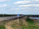
which runs 29 km in length. It runs from Highway 16
Saskatchewan Highway 16
Highway 16 is a provincial paved highway in the Canadian province of Saskatchewan. It is the Saskatchewan section of the Yellowhead Highway, and also the Trans-Canada Highway Yellowhead section. The main purpose of this highway is to connect Saskatchewan with Canadian cities such as Edmonton and...
near Clavet
Clavet, Saskatchewan
-External links:*...
to Highway 5
Saskatchewan Highway 5
This article focuses on the current designated Saskatchewan Highway 5, for Provincial Highway 5, Evergreen route portion, north west of Saskatoon see Saskatchewan Highway 16....
. Highway 316 is about 17 km (11 mi.) long. This area is an industrial commercial area along Highway #316 which extends from Clavet north to the PCS Patience Lake Mine which is just 10 miles from the city of Saskatoon
Saskatoon
Saskatoon is a city in central Saskatchewan, Canada, on the South Saskatchewan River. Residents of the city of Saskatoon are called Saskatonians. The city is surrounded by the Rural Municipality of Corman Park No. 344....
. Highway 316 is a primary weight highway, and also runs near the Canadian National Railway
Canadian National Railway
The Canadian National Railway Company is a Canadian Class I railway headquartered in Montreal, Quebec. CN's slogan is "North America's Railroad"....
line which goes from Saskatoon
Saskatoon
Saskatoon is a city in central Saskatchewan, Canada, on the South Saskatchewan River. Residents of the city of Saskatoon are called Saskatonians. The city is surrounded by the Rural Municipality of Corman Park No. 344....
through Clavet
Clavet, Saskatchewan
-External links:*...
. In 1941, the Canadian Pacific Railway
Canadian Pacific Railway
The Canadian Pacific Railway , formerly also known as CP Rail between 1968 and 1996, is a historic Canadian Class I railway founded in 1881 and now operated by Canadian Pacific Railway Limited, which began operations as legal owner in a corporate restructuring in 2001...
ran from Saskatoon
Saskatoon
Saskatoon is a city in central Saskatchewan, Canada, on the South Saskatchewan River. Residents of the city of Saskatoon are called Saskatonians. The city is surrounded by the Rural Municipality of Corman Park No. 344....
through Cheviot and on south eastward.
Highway 316 passes near the community of Cheviot and intersects Highway 394
Saskatchewan Highway 394
Highway 394 is a highway in the Canadian province of Saskatchewan. It starts near an intersection between Highway 16 and Haight Road/Zimmerman Road/Range Road 3044 near Saskatoon, and goes eastward to Highway 316 north of Clavet. Highway 394 does not pass through any communities, and its signage...
.
Communities along the route
- ClavetClavet, Saskatchewan-External links:*...
is a village which can be found at 52°00′00"N 106°23′00"W or legal land description of Section 9 Township 35 Range 3 -West of the 3rd Meridian106th meridian westThe meridian 106° west of Greenwich is a line of longitude that extends from the North Pole across the Arctic Ocean, North America, the Pacific Ocean, the Southern Ocean, and Antarctica to the South Pole.... - Cheviot, Saskatchewan, a small unincorporated area was the childhood home of Neil McArthur inducted into the Saskatchewan Agricultural Hall of Fame. This area is located at 52°02′00"N 106°22′00"W or legal land description of Section 28 - Township 35- Range 3 -West of the 3rd Meridian
- Muskeg Lake First Nation Indian Reserve 102A
Rural municipalities along the route
- Blucher No. 343Blucher No. 343, SaskatchewanBlucher No. 343 is a rural municipality in north-central Saskatchewan on the South Saskatchewan River. It is located in Division No. 15.According to the Canada 2001 Census:*Population: 1476*% Change : 27.8*Dwellings: 567*Area : 789.28...
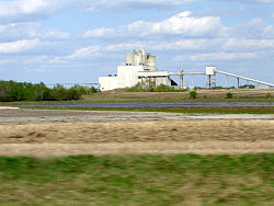
is home to several industrial/commercial enterprises. Potash mining, anhydrous ammonia-bulk fertilizer distribution centres, canola crushing plant, as well as a large inland grain terminal.
Major attractions
- Potash Corporation of Saskatchewan (PCS) Patience Lake Mine
- Cheviot Lake is located at 52°02′00"N 106°20′00"W or legal land description of Township 35 - Range 3 -West of the 3rd Meridian106th meridian westThe meridian 106° west of Greenwich is a line of longitude that extends from the North Pole across the Arctic Ocean, North America, the Pacific Ocean, the Southern Ocean, and Antarctica to the South Pole....
which is just east of Cheviot.
The following lakes are all north of Highway 316:
- Porter Lake 52°17′00"N 106°17′00"W or legal land description of Township 37- Ranges 2,3 - W of the 3rd Meridian
- Patience LakePatience LakePatience Lake is a lake in central Saskatchewan, Canada east of Saskatoon. The lake is located in the rural municipality of Blucher No. 343. The lake serves as a groundwater discharge region for higher elevations to the east and west....
Is located at 52°07′00"N 106°20′00"W or legal land description of Township 36 - Range 3 -West of the 3rd Meridian - Burke Lake is located at 52°10′00"N 106°18′00"W or legal land description of Township 37- Range 3 -West of the 3rd Meridian
External links