
Saraburi Province
Encyclopedia
Saraburi is one of the central provinces
(changwat) of Thailand
. Neighboring provinces are (from north clockwise) Lopburi
, Nakhon Ratchasima
, Nakhon Nayok
, Pathum Thani and Ayutthaya
. Saraburi has been an important town since ancient times. It is believed to have been constructed in the year 1548 during the reign of King Maha Chakkraphat of Ayutthaya
as a centre for recruiting troops.
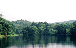 Saraburi is located on the east side of the Chao Phraya river valley. The east part of the province is covered by high plains and plateaus, while the western part is mostly low flat plains.
Two national parks are located in the province. Namtok Chet Sao Noi protects 28 km² around a scenic waterfall. Phra Phutthachai protects the Khao Sam Lan Forest, which consists of hilly landscape and is the source to several rivers and waterfalls. The highest elevation is the Khao Khrok, 329 m above sea level. The 44.57 km² were declared a national park in 1981.
The town, as a gateway to the northeastern region, is only 108 km from Bangkok
. It occupies an area of 3,576.5 square kilometres.
in the 17th century, is located around a Buddha footprint. It is the most popular pilgrimage site within central Thailand.
Close to that temple, Wat Tham Krabok
is famous for its drug detoxification. Additionally it was the last of the Hmong
refugee camps in Thailand.
shows the temple Wat Phra Buddha Baat. In the 17th century a hunter found a puddle of water which looked like a large footprint. It was declared a footprint of Buddha
, and the temple was built around it. Phra Phutthabat means footprint of Buddha.
Provincial tree is Lagerstroemia floribunda
, provincial flower is the Yellow Cotton Tree (Cochlospermum regium).
 The province is subdivided into 13 districts (amphoe
). The districts are further subdivided into 111 communes (tambon
) and 965 villages (muban
).
Wat Phra Phutthachai: This temple is situated on a hillside. The main attraction is a picture of Lord Buddha appearing on a cliff wall. A Wihara has been built to cover it. The surroundings are very pleasant and shady.
Khao Sam Lan National Park: This is the nearest national park where tourists can take a short journey form Bangkok. It is 4 km beyond Wat Phra Phutthachai. The park offers many small waterfalls, some of which can be reached by short hiking trails. The best time to visit the falls is the late rainy season when water is plentiful.
Crocodile Farm and Zoo (ฟาร์มจระเข้ และสวนสัตว์): Besides crocodiles, there are many other kinds of animals such as deer, monkeys, and various species of birds.
Phra Phuttha Nirarokhantarai Chaiwat Chaturathit (พระพุทธนิรโรคันตรายชัยวัฒน์จตุรทิศ): It is the Buddha image of the East and one of the four images made by the Territorial Defence Department to express loyalty to King Rama VI and King Rama IX. It resides in the cruciform pavilion of Wat Sala Daeng.
Phu Khae Botanical Garden (สวนพฤกษศาสตร์ภาคกลาง (พุแค): Established in 1941 as the first Royal Forest Department Botanical garden ever, it sprawls over an area of 300 ha of which 100 ha is natural vegetation and forest. It also features a literary garden, comprising 35 species of plants which are mentioned in Thai literature. It also contains a medicinal garden.
Tham Si Wilai (ถ้ำศรีวิไล): A cave in which resides the Phra Phutthanaowarat Buddha image from the Chiang Saen
period. The cave also features stalagmite
s and stalactite
s.
Sao Ronghai (เสาร้องไห้): A gigantic post made from a hardwood tree known as Takhian, which is believed to possess a female spirit called "Takhian Thong". This post was submerged under water at this sub-district for more than 100 years until in 1958, the locals brought it out of the water and kept it in the shrine.
The Golden Buddha Image (พระพุทธรูปทองคำ): A Buddha image in the meditation posture. The Fine Arts Department examined it and analysed that it is 70% gold. Therefore, the locals named it "Luangpho Thongkham", the "Golden Buddha image".
Wat Phayao (วัดพะเยาว์): The golden Buddha image of Wat Phayao is considered as one of the major sculptures of Ayutthaya
period. The believers built a viharn with a cruciform plan as a residence for the Buddha image to enhance its dignity and to bring honour to the people of Saraburi.
Wat Khao Kaeo Worawihan (วัดเขาแก้ววรวิหาร) When King Rama IV visited Sao Hai District, he ordered the renovation of this temple and promoted it as a royal temple. There has been a rumor that a bright crystal ball would appear over the viharn of Wat Khao Khaeo on some nights.
Ban Khao Kaeo (บ้านเขาแก้ว): A traditional Thai wooden house of approximately 80-100 years old. It is the property of Achan Songchai Wannakun. The house was established as the "Thai Yuan Cultural Study Centre", collecting folk utensils, weapons, present day tools as well as ancient woven textiles of over 100 years old.
Bencha Sutthi Khongkha (เบญจสุทธิคงคา) refers to the sacred water from one of the five important rivers that flow through Sao Hai District. It is used for the Oath of Allegiance Ceremony ever since the reign of King Rama IV until the present time.
Wat Samuha Pradittharam (วัดสมุหประดิษฐาราม): Inside this temple one can find beautiful mural
s depicting the Khawi folk tale. The main Buddha image, in the posture of subduing Mara, was taken from Sukhothai
’s Ancient City. It is cast in bronze and covered with gold leaf.
Wat Chanthaburi (วัดจันทบุรี): The main attraction is the ubosoth
, constructed in 1893 during the reign of King Rama III. Inside are beautiful murals of the same period as the ubosot. They are still in perfect condition and depict the gathering of angels and the story of the Lord Buddha.
Weaving Centre of Tambon Ban Ton Tan (ศูนย์การเรียนรู้ทอผ้าตำบลบ้านต้นตาล): This centre is an educational facility for the youth and general public. There are various kinds of woven fabric on display such as loincloth, plain coloured cloth, Pha Si Khao, and fabric in the Dok Phikun – bullet wood flower – pattern, which is a traditional Thai Yuan style.
Thanon Phrachao Songtham or Thanon Farang Song Klong (ถนนพระเจ้าทรงธรรม หรือ ถนนฝรั่งส่องกล้อง): A road constructed during the reign of King Songtham
who reigned from 1611 to 1628. At present, approximately 9 kilometres of the path can still be seen. It starts opposite Wat Sang Sok. It was changed into a laterite
and concrete road with a width of 6-8 metres.
Thale Ban Mo (ทะเลบ้านหมอ): A deep and wide pond with a serene atmosphere, it is the habitat of various water creatures. From February until July, large flocks of migratory birds from Siberia can be found here.
Samnak Song Tham Krabok (สำนักสงฆ์ถ้ำกระบอก): A well-known rehabilitation centre for drug addicts. This monastic residence was established by a Buddhist nun, Mian Panchan, in 1957.
Bo Phran Lang Nuea (บ่อพรานล้างเนื้อ): A small stone well near Wat Phra Phutthabat. At the mouth of the well are knee prints. There are stone slopes and a deep hole the size of a can of milk near the well. The water that flows from the hole is believed to be holy water
.
Phra Tamnak Than Kasem (พระตำหนักธารเกษม): This palace was built in 1633 during the reign of King Prasat Thong
as his residence on his royal visit to pay respect to Phra Phutthabat. The base of the palace still remains.
Tham Thep Nimit Than Thong Daeng (ถ้ำเทพนิมิตรธารทองแดง): It is a prehistoric archaeological site. Artefacts of the late Neolithic
period were discovered here.
Tham Narai or Tham Khao Wong (ถ้ำนารายณ์ หรือถ้ำเขาวง): It is a cave containing stalagmite
s and stalactite
s as well as ancient Mon
scripts at the entrance of the cave.
Tamnak Sa Yo (ตำหนักสระยอ): A royal residence constructed at the edge of Than Thong Daeng by Somdet Phrachao Prasat Thong’s command for his visit to pay respect to Phra Phutthabat.
Phra Tamnak Thai Phikun, the Ancient Palace (พระตำหนักท้ายพิกุล พระราชวังโบราณ) In the present, there are no remains left of the actual palace. Only the royal elephant mounting platform and the surrounding wall are left.
Tham Phrathat Charoen Tham or Tham Bo Pla (ถ้ำพระธาตุเจริญธรรม หรือถ้ำบ่อปลา): The cave is divided into 3 big rooms. In the cave resides Luangpho Yai, a stucco Buddha image with black lacquer applied and covered with gold leaf in the gesture of subduing Mara. It is from the Ayutthaya period.
Pha Sadet (ผาเสด็จ) It is the cliff where King Rama V and the Queen resided when the Bangkok – Nakhon Ratchasima railway was constructed in 1895. Both of them also inscribed their royal initials, Cho Pho Ro and So Pho at the cliff.
Tham Phra Phothisat (ถ้ำพระโพธิสัตว์): A bas-relief from the Dvaravati
period can be found on the cave wall, depicting the preaching Buddha as well as Hindu
gods. Outside the cave are many trees of various kinds as well as the royal initials, Cho Pho Ro, inscribed by King Rama V when he visited the waterfall. It consists of Tham Thammathat, Tham Lumphini, a stone garden and Tham Sa-ngat Chedi.
Khao Phra Phutthabat Noi (เขาพระะพุทธบาทน้อย) features undulating steep limestone mountains with many pointed summits. Inside lies a replica of the Buddha’s footprint, around 1 cubit
wide and 3 cubits long imprinted deep into the ground.
Phra Bowon Ratchawang Si Tha (พระบวรราชวังสีทา): The compound of this residence was very large, covering an area of approximately more than 150 rai
. There still remains the lotus
base for a wooden house made of brick and cement. There is an area of around 4 rai left which the Kamnan - village headman, Mr. Suphat Ritthichampha, has reserved as a public area.
Ban Dong Nam Bo Archaeological Site (แหล่งโบราณคดีบ้านดงน้ำบ่อ): It is a cemetery where burial ceremonies were conducted and an archaeological site of the Pa Sak River
culture. Also, iron and stone tools, jewellery, bangles and beads, aged approximately 2,000 years, were discovered.
Chet Khot - Pong Kon Sao Nature and Ecotourism Study Centre (ศูนย์ศึกษาธรรมชาติและท่องเที่ยวเชิงนิเวศเจ็ดคด-โป่งก้อนเส้า): The centre features a large biodiversity of both plants and animals. It comprises many kinds of forests such as dry evergreen forest, moist evergreen forest, mixed deciduous forest and savanna. Animals living in this compound are wild elephants, gaurs, bears, deer, barking deer, lories, mouse deer, wild boar and approximately 158 kinds of birds.
Nature Study Routes (เส้นทางศึกษาธรรมชาติ): There are 3 overall. The first route is from the sightseeing spot located 12 kilometres from the centre. The second route is from Sap Pa Wan Reservoir to Hin Dat Waterfall. The third route is from Sap Pa Wan Reservoir to Namtok Chet Khot Nuea, Klang and Tai. Other waterfalls found in the area and nearby are equally splendid. Significant are the Namtok Khao Khaep, the Namtok Krok Fa Phanang and the Namtok Sap Pa Wan.
Sekeikyuseikyo Thai Headquarters (องค์การศาสนาเซไคคิวเซเคียวประจำประเทศไทย) lies the tropical Miroku Botanic Garden. There is also a pool, marble sculptures in various shapes, and a Japanese garden with a beautiful landscape. On the other side of the project lies an organic demonstration vegetable plot by using the Effective Microorganisms (EM) technology: a use of a micro-organism to reduce pollution in the environment.
Rafting along the Pa Sak River (การล่องแม่น้ำป่าสัก): The natural surroundings on both sides of the river is beautiful. The mountains line up along the rafting route. At some parts stones and cliffs can be seen with strange shapes, similar to animals.
Namtok Heo Noi (น้ำตกเหวน้อย): Proceeding further from this waterfall, there are high waterfalls in Khao Yai National Park. The best time to visit is from July to November.
Muak Lek Arboretum (สวนรุกขชาติมวกเหล็ก) and Namtok Muak Lek (น้ำตกมวกเหล็ก): The lively stream originates from its tributaries in the Khao Yai National Park
that flow into the Pa Sak River which forms the border between two provinces. The stream has rocky slopes that form small beautiful cascades.
Namtok Chet Sao Noi National Park (อุทยานแห่งชาติน้ำตกเจ็ดสาวน้อย) The waterfall has 7 levels. The height of each level is approximately 4 metres and offers a spacious shaded swimming area.
Namtok Sap Heo (น้ำตกซับเหว): This waterfall also features a large basin suitable for swimming. On the right side of the waterfall is a path to a small cave which houses stalagmites and stalactites. Trekking to the waterfall is quite difficult.
Tham Dao Khao Kaeo (ถ้ำดาวเขาแก้ว): The distinguishing points of this cave are its red, black and brown spots on the ceiling as well as the stalagmites and stalactites and its large population of bats.
The Dairy Farming Promotion Organisation of Thailand (องค์การส่งเสริมกิจการโคนมแห่งประเทศไทย (อ.ส.ค.)): The Danish government and the Danish Dairy Farming Association together offered a promotion project on the raising of dairy cows. They cooperated with the Thai government to establish the Thai-Danish Dairy Farm (TDDF) and a training centre in Muak Lek District, Saraburi.
Pa Sak Jolasid Dam (เขื่อนป่าสักชลสิทธิ์): It was selected as one of the "Unseen Thailand Destinations". It is the longest earth filled dam in Thailand with a length of 4,860 metres along the crest.
Tree Tunnel (อุโมงค์ต้นไม้) is an arch formed by trees bent towards each other on both sides of the road, forming a 200-metre long beautifully shaded "tunnel".
Sunflower Fields (ทุ่งทานตะวัน) are found between Lop Buri and Saraburi along the Phatthana Nikhom – Wang Muang route. From November to December, the yellow sunflower fields along the road attract many people.
Chedi Phrakhun Mae (เจดีย์พระคุณแม่): The chedi is surrounded by Buddha images representing the seven days of the week. It was constructed to encourage children to remember the kindness of their mothers and to be good in return.
Phai Tam Sub-district Bird Garden (สวนนกธรรมชาติตำบลไผ่ต่ำ): The garden covers an area of approximately 3 rai and is the residence of more than 17 species of birds. These birds always find their food early in the morning and fly back to their nest at dust.
(ปีนหน้าผา-โรยตัว): At Wat Phra Chai, Mueang District, is a large cliff with a height of 35 metres appropriate for the cliff climbing with a climb of less than 5 metres high without the use of a rope. However, cushions are provided on the ground below and a climbing partner will always take care and block from behind the climber. The spot is on a mountain which is surrounded with cliffs on every side. On the east of Wat Phra Phutthachai lie large round stones alternating with timber forests. On the other route is a climbing location with a rope or Top Rope with a length of 40 metres. Also, this is a sightseeing spot for the plain of the Pa Sak River as well as the scenery of Saraburi.
Tham Lumphini Suan Hin (ถ้ำลุมพินีสวนหิน): A cave in Kaeng Khoi District with a length of 1,800 metres. It is the longest cave in perfect condition of Saraburi created naturally by underground water.
Other famous local food products are "Herbal Chinese Pork Sausage with Iodine" (Kun Chiang), "Sweet Dried Pork" (Mu Sawan), "Pounded Pork" (Mu Thup) and "Pork Stewed in Gravy" (Mu Phalo) and "Krayasat" (cereals and nuts in honey caramel).
Local Hand-woven Fabrics are Tin Chok, silk, and Mudmee
textiles of the Thai Yuan
people.
The Phra Phutthabat Homage Paying Fair (งานนมัสการรอยพระพุทธบาท) is held twice a year: starting on the first day of the waxing moon and continuing for 15 days until the full moon day in the third lunar month; and from the eighth day of the waxing moon, continuing for 8 days until the full moon day in the fourth lunar month.
The Kam Fa Festival (ประเพณีกำฟ้า) is held on the second day of the waxing moon in the third lunar month. The eve of the festival features various forms of folk entertainment and activities including cockfighting and toasting sticky rice in bamboo. The Kam Fa Festival occurs on the third day of the waxing moon in the third lunar month. People perform merit making and attend sermons. The festival takes place annually at Phai Lio Sub-district, Don Phut District.
The Wat Sung Songkran Festival and Sao Nang Takhian Bathing (ประเพณีสงกรานต์สรงน้ำเสานางตะเคียนวัดสูง) is held annually on April 23 in front of Wat Sung’s ordination hall, Sao Hai District. People perform merit making ceremonies and pour water onto elders and onto the Nang Takhian pillar.
Hae Phra Khiao Kaeo (ประเพณีแห่พระเขี้ยวแก้ว): Buddhists believe that Phra Khiao Kaeo was the tooth of the Lord Buddha. A festival is held on the first day of the waxing moon in the fourth lunar month. The people of Amphoe Phra Phutthabat take the tooth from Wat Phra Phutthabat Ratchaworamahawihan Museum and carry it in a procession around the town. They believe that if the procession is held, they will live in wealth and happiness. It is an annual tradition of Phra Phutthabat District.
The Chaopho Khao Tok Fair or Chaopho Khao Tok Procession (ประเพณีเจ้าพ่อเขาตก หรือ งานแห่เจ้าพ่อเขาตก) is held at Wat Phra Phutthabat Ratchaworamahawihan, Phra Phutthabat District, and is an annual fair. The event features supernatural power performances of Chaopho Khao Tok such as fire walking. There is also the Lo Ko dragon parade and Chinese opera
performances. Mainly Chinese people, especially the followers of Chaopho Khao Tok, come from all over the country to celebrate this festival. The event begins on the first day of the waxing moon in the fourth lunar month, and continues for 4 days.
The Tak Bat Dok Mai Ceremony (ประเพณีตักบาตรดอกไม้) is considered a significant tradition of Phra Phutthabat District. This merit-making ceremony is held to coincide with the start of the annual three-month Buddhist Lent on the first day of the waning moon of the eighth lunar month. During the ceremony, people offer alms to monks and candles to Wat Phra Phutthabat, early in the morning. In the afternoon, they offer flowers to the monks at Wat Phra Phutthabat Ratchaworamahawihan, Khun Khlon Sub-district, Phra Phutthabat District. They go to collect a kind of flower similar to Krachai (Rotunda) or turmeric with yellow or white flowers called “The Flower of Buddhist Lent”. This herb-like flower is found on the hillside only during the Buddhist Lent period and only in Saraburi. While the monks are walking up the staircase to take the flowers to pay homage to the Lord Buddha’s footprint, people wait along the steps with bowls of clean water in which are floated bullet wood flowers. They pour the water onto the feet of the monks as a means of washing away their sins. The Flower of Buddhist Lent was listed as a new species of plant in the world in the International Flowers Fair in July 2001 at Jurong Bird Park in Singapore
.
The Pa Sak Boat Racing Festival (การแข่งขันเรือยาวประเพณีลุ่มน้ำป่าสัก) is a major annual regatta that takes place at the pier in front of the Sao Hai District Office on the last Saturday or Sunday of September. Famous long boats from all over the country join in the race. There are four categories: boats with 55 paddlers, 30 paddlers, 12 paddlers, and 10 paddlers. This festival is a way to preserve the local tradition.
Provinces of Thailand
Thailand is divided into 76 provinces , which are geographically grouped into 6 regions. The capital Bangkok is not a province but a special administrative area and is included as the 77th province since it is administered at the same level as the other 76 provinces. The name of the provinces are...
(changwat) of Thailand
Thailand
Thailand , officially the Kingdom of Thailand , formerly known as Siam , is a country located at the centre of the Indochina peninsula and Southeast Asia. It is bordered to the north by Burma and Laos, to the east by Laos and Cambodia, to the south by the Gulf of Thailand and Malaysia, and to the...
. Neighboring provinces are (from north clockwise) Lopburi
Lopburi Province
Lop Buri is one of the central provinces of Thailand. Neighboring provinces are Phetchabun, Chaiyaphum, Nakhon Ratchasima, Saraburi, Phra Nakhon Si Ayutthaya, Ang Thong, Sing Buri and Nakhon Sawan.-Geography:...
, Nakhon Ratchasima
Nakhon Ratchasima Province
Nakhon Ratchasima or , often shortened to Korat or Khorat , is one of the north-eastern provinces of Thailand...
, Nakhon Nayok
Nakhon Nayok Province
Nakhon Nayok is one of the central provinces of Thailand. Neighboring provinces are Saraburi, Nakhon Ratchasima, Prachinburi, Chachoengsao and Pathum Thani....
, Pathum Thani and Ayutthaya
Ayutthaya Province
Phra Nakhon Si Ayutthaya is one of the central provinces of Thailand. Neighboring provinces are Ang Thong, Lop Buri, Saraburi, Pathum Thani, Nonthaburi, Nakhon Pathom and Suphan Buri....
. Saraburi has been an important town since ancient times. It is believed to have been constructed in the year 1548 during the reign of King Maha Chakkraphat of Ayutthaya
Ayutthaya kingdom
Ayutthaya was a Siamese kingdom that existed from 1350 to 1767. Ayutthaya was friendly towards foreign traders, including the Chinese, Vietnamese , Indians, Japanese and Persians, and later the Portuguese, Spanish, Dutch and French, permitting them to set up villages outside the walls of the...
as a centre for recruiting troops.
Geography
Two national parks are located in the province. Namtok Chet Sao Noi protects 28 km² around a scenic waterfall. Phra Phutthachai protects the Khao Sam Lan Forest, which consists of hilly landscape and is the source to several rivers and waterfalls. The highest elevation is the Khao Khrok, 329 m above sea level. The 44.57 km² were declared a national park in 1981.
The town, as a gateway to the northeastern region, is only 108 km from Bangkok
Bangkok
Bangkok is the capital and largest urban area city in Thailand. It is known in Thai as Krung Thep Maha Nakhon or simply Krung Thep , meaning "city of angels." The full name of Bangkok is Krung Thep Mahanakhon Amon Rattanakosin Mahintharayutthaya Mahadilok Phop Noppharat Ratchathani Burirom...
. It occupies an area of 3,576.5 square kilometres.
History
Saraburi has been an important city since ancient times. It is assumed to have been established approximately in 1549 during the reign of King Maha Chakkraphat of the Kingdom of Ayutthaya. It is assumed that the king had ordered to combine some parts of Lop Buri and Nakhon Nayok together and set up Saraburi province with an aim to be a centre for mobilizing the citizens during times of war. Therefore, from the Ayutthaya period, the story of Saraburi has usually related to battles and wars. As for the origin of the word “Saraburi”, it is assumed that due to its location near a swamp called “Bueng Nong Ngong”, when the town was established a combination of “Sa” -a swamp- and “Buri” -a town- was suggested and the town was named “Saraburi”.Places
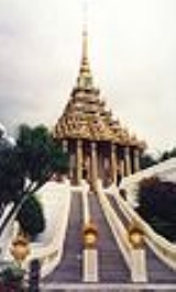
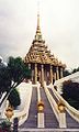
The most important Buddhist temple is Wat Phra Phutthabat, built under King SongthamSongtham
Somdet Phra Boromma Trailokanat Songtham was the King of Ayutthaya from 1611 to 1628 of the House of Sukhōday. His reign was marked as prosperity after the First Fall of Ayutthaya and saw the commencement of trade with foreign nations especially the Dutch and the Japanese...
in the 17th century, is located around a Buddha footprint. It is the most popular pilgrimage site within central Thailand.
Close to that temple, Wat Tham Krabok
Wat Tham Krabok
Wat Tham Krabok is a Buddhist temple in Thailand, located in the Phra Phutthabat district of Saraburi Province.The temple was first established as a monastery in 1958 by the Buddhist nun Mae Chee Boonruen. It was upgraded to temple status 17 years later, in 1975...
is famous for its drug detoxification. Additionally it was the last of the Hmong
Hmong people
The Hmong , are an Asian ethnic group from the mountainous regions of China, Vietnam, Laos, and Thailand. Hmong are also one of the sub-groups of the Miao ethnicity in southern China...
refugee camps in Thailand.
Symbols
The provincial sealSeals of The Provinces of Thailand
-Present-day provinces of Thailand:This list includes all the seals of the Provinces of Thailand. It also includes the special administrative area of the capital, Bangkok.-Former Provinces:-External links:*...
shows the temple Wat Phra Buddha Baat. In the 17th century a hunter found a puddle of water which looked like a large footprint. It was declared a footprint of Buddha
Gautama Buddha
Siddhārtha Gautama was a spiritual teacher from the Indian subcontinent, on whose teachings Buddhism was founded. In most Buddhist traditions, he is regarded as the Supreme Buddha Siddhārtha Gautama (Sanskrit: सिद्धार्थ गौतम; Pali: Siddhattha Gotama) was a spiritual teacher from the Indian...
, and the temple was built around it. Phra Phutthabat means footprint of Buddha.
Provincial tree is Lagerstroemia floribunda
Lagerstroemia floribunda
Lagerstroemia floribunda is a species in the Lythraceae family....
, provincial flower is the Yellow Cotton Tree (Cochlospermum regium).
Administrative divisions
Amphoe
An amphoe is the second level administrative subdivision of Thailand. Usually translated as district, amphoe make up the provinces, and are analogous to a county seat...
). The districts are further subdivided into 111 communes (tambon
Tambon
Tambon is a local government unit in Thailand. Below district and province , they form the third administrative subdivision level. As of the 2009 there are 7255 tambon, not including the 169 khwaeng of Bangkok, which are set at the same administrative level, thus every district contains 8-10 tambon...
) and 965 villages (muban
Muban
Muban is the lowest administrative subdivision of Thailand. Usually translated as village, they are the subdivision of tambon. As of 2008, there are 74944 administrative villages in Thailand. As of the 1990 census, the average village consisted of 144 households or 746 persons.A muban does not...
).
|
|
Sights
Wat Phra Phutthabat: This temple is located in Amphoe Phra Phutthabat, 28 km north of the town along Highway No.1. It is one of the most beautiful religious sites in Thailand. The temple houses the footprint of Lord Buddha found on a stone panel near Suwan Banpot Hill. The footprint was found in the reign of King Songtham of Ayutthaya. A spired square pavilion or mondop was built to cover the footprint.Wat Phra Phutthachai: This temple is situated on a hillside. The main attraction is a picture of Lord Buddha appearing on a cliff wall. A Wihara has been built to cover it. The surroundings are very pleasant and shady.
Khao Sam Lan National Park: This is the nearest national park where tourists can take a short journey form Bangkok. It is 4 km beyond Wat Phra Phutthachai. The park offers many small waterfalls, some of which can be reached by short hiking trails. The best time to visit the falls is the late rainy season when water is plentiful.
Crocodile Farm and Zoo (ฟาร์มจระเข้ และสวนสัตว์): Besides crocodiles, there are many other kinds of animals such as deer, monkeys, and various species of birds.
Phra Phuttha Nirarokhantarai Chaiwat Chaturathit (พระพุทธนิรโรคันตรายชัยวัฒน์จตุรทิศ): It is the Buddha image of the East and one of the four images made by the Territorial Defence Department to express loyalty to King Rama VI and King Rama IX. It resides in the cruciform pavilion of Wat Sala Daeng.
Phu Khae Botanical Garden (สวนพฤกษศาสตร์ภาคกลาง (พุแค): Established in 1941 as the first Royal Forest Department Botanical garden ever, it sprawls over an area of 300 ha of which 100 ha is natural vegetation and forest. It also features a literary garden, comprising 35 species of plants which are mentioned in Thai literature. It also contains a medicinal garden.
Tham Si Wilai (ถ้ำศรีวิไล): A cave in which resides the Phra Phutthanaowarat Buddha image from the Chiang Saen
Chiang Saen
* Amphoe Chiang Saen, a district in modern Chiang Rai Province* Chiang Saen, a capital in the ancient Lanna kingdom, and the namesake of the modern district...
period. The cave also features stalagmite
Stalagmite
A stalagmite is a type of speleothem that rises from the floor of a limestone cave due to the dripping of mineralized solutions and the deposition of calcium carbonate. This stalagmite formation occurs only under certain pH conditions within the underground cavern. The corresponding formation on...
s and stalactite
Stalactite
A stalactite , "to drip", and meaning "that which drips") is a type of speleothem that hangs from the ceiling of limestone caves. It is a type of dripstone...
s.
Sao Ronghai (เสาร้องไห้): A gigantic post made from a hardwood tree known as Takhian, which is believed to possess a female spirit called "Takhian Thong". This post was submerged under water at this sub-district for more than 100 years until in 1958, the locals brought it out of the water and kept it in the shrine.
The Golden Buddha Image (พระพุทธรูปทองคำ): A Buddha image in the meditation posture. The Fine Arts Department examined it and analysed that it is 70% gold. Therefore, the locals named it "Luangpho Thongkham", the "Golden Buddha image".
Wat Phayao (วัดพะเยาว์): The golden Buddha image of Wat Phayao is considered as one of the major sculptures of Ayutthaya
Ayutthaya kingdom
Ayutthaya was a Siamese kingdom that existed from 1350 to 1767. Ayutthaya was friendly towards foreign traders, including the Chinese, Vietnamese , Indians, Japanese and Persians, and later the Portuguese, Spanish, Dutch and French, permitting them to set up villages outside the walls of the...
period. The believers built a viharn with a cruciform plan as a residence for the Buddha image to enhance its dignity and to bring honour to the people of Saraburi.
Wat Khao Kaeo Worawihan (วัดเขาแก้ววรวิหาร) When King Rama IV visited Sao Hai District, he ordered the renovation of this temple and promoted it as a royal temple. There has been a rumor that a bright crystal ball would appear over the viharn of Wat Khao Khaeo on some nights.
Ban Khao Kaeo (บ้านเขาแก้ว): A traditional Thai wooden house of approximately 80-100 years old. It is the property of Achan Songchai Wannakun. The house was established as the "Thai Yuan Cultural Study Centre", collecting folk utensils, weapons, present day tools as well as ancient woven textiles of over 100 years old.
Bencha Sutthi Khongkha (เบญจสุทธิคงคา) refers to the sacred water from one of the five important rivers that flow through Sao Hai District. It is used for the Oath of Allegiance Ceremony ever since the reign of King Rama IV until the present time.
Wat Samuha Pradittharam (วัดสมุหประดิษฐาราม): Inside this temple one can find beautiful mural
Mural
A mural is any piece of artwork painted or applied directly on a wall, ceiling or other large permanent surface. A particularly distinguishing characteristic of mural painting is that the architectural elements of the given space are harmoniously incorporated into the picture.-History:Murals of...
s depicting the Khawi folk tale. The main Buddha image, in the posture of subduing Mara, was taken from Sukhothai
Sukhothai kingdom
The Sukhothai Kingdom ) was an early kingdom in the area around the city Sukhothai, in north central Thailand. The Kingdom existed from 1238 till 1438...
’s Ancient City. It is cast in bronze and covered with gold leaf.
Wat Chanthaburi (วัดจันทบุรี): The main attraction is the ubosoth
Ubosoth
A phra ubosot is a building in a Buddhist Wat. It is the holiest prayer room, also called the "ordination hall" as it is where ordinations take place....
, constructed in 1893 during the reign of King Rama III. Inside are beautiful murals of the same period as the ubosot. They are still in perfect condition and depict the gathering of angels and the story of the Lord Buddha.
Weaving Centre of Tambon Ban Ton Tan (ศูนย์การเรียนรู้ทอผ้าตำบลบ้านต้นตาล): This centre is an educational facility for the youth and general public. There are various kinds of woven fabric on display such as loincloth, plain coloured cloth, Pha Si Khao, and fabric in the Dok Phikun – bullet wood flower – pattern, which is a traditional Thai Yuan style.
Thanon Phrachao Songtham or Thanon Farang Song Klong (ถนนพระเจ้าทรงธรรม หรือ ถนนฝรั่งส่องกล้อง): A road constructed during the reign of King Songtham
Songtham
Somdet Phra Boromma Trailokanat Songtham was the King of Ayutthaya from 1611 to 1628 of the House of Sukhōday. His reign was marked as prosperity after the First Fall of Ayutthaya and saw the commencement of trade with foreign nations especially the Dutch and the Japanese...
who reigned from 1611 to 1628. At present, approximately 9 kilometres of the path can still be seen. It starts opposite Wat Sang Sok. It was changed into a laterite
Laterite
Laterites are soil types rich in iron and aluminium, formed in hot and wet tropical areas. Nearly all laterites are rusty-red because of iron oxides. They develop by intensive and long-lasting weathering of the underlying parent rock...
and concrete road with a width of 6-8 metres.
Thale Ban Mo (ทะเลบ้านหมอ): A deep and wide pond with a serene atmosphere, it is the habitat of various water creatures. From February until July, large flocks of migratory birds from Siberia can be found here.
Samnak Song Tham Krabok (สำนักสงฆ์ถ้ำกระบอก): A well-known rehabilitation centre for drug addicts. This monastic residence was established by a Buddhist nun, Mian Panchan, in 1957.
Bo Phran Lang Nuea (บ่อพรานล้างเนื้อ): A small stone well near Wat Phra Phutthabat. At the mouth of the well are knee prints. There are stone slopes and a deep hole the size of a can of milk near the well. The water that flows from the hole is believed to be holy water
Holy water
Holy water is water that, in Catholicism, Anglicanism, Eastern Orthodoxy, Lutheranism, Oriental Orthodoxy, and some other churches, has been sanctified by a priest for the purpose of baptism, the blessing of persons, places, and objects; or as a means of repelling evil.The use for baptism and...
.
Phra Tamnak Than Kasem (พระตำหนักธารเกษม): This palace was built in 1633 during the reign of King Prasat Thong
Prasat Thong
King Prasat Thong was the first king of Prasat Thong dynasty, the 4th dynasty of Ayutthaya kingdom. He was the Defense minister of King Songtham....
as his residence on his royal visit to pay respect to Phra Phutthabat. The base of the palace still remains.
Tham Thep Nimit Than Thong Daeng (ถ้ำเทพนิมิตรธารทองแดง): It is a prehistoric archaeological site. Artefacts of the late Neolithic
Neolithic
The Neolithic Age, Era, or Period, or New Stone Age, was a period in the development of human technology, beginning about 9500 BC in some parts of the Middle East, and later in other parts of the world. It is traditionally considered as the last part of the Stone Age...
period were discovered here.
Tham Narai or Tham Khao Wong (ถ้ำนารายณ์ หรือถ้ำเขาวง): It is a cave containing stalagmite
Stalagmite
A stalagmite is a type of speleothem that rises from the floor of a limestone cave due to the dripping of mineralized solutions and the deposition of calcium carbonate. This stalagmite formation occurs only under certain pH conditions within the underground cavern. The corresponding formation on...
s and stalactite
Stalactite
A stalactite , "to drip", and meaning "that which drips") is a type of speleothem that hangs from the ceiling of limestone caves. It is a type of dripstone...
s as well as ancient Mon
Mon people
The Mon are an ethnic group from Burma , living mostly in Mon State, Bago Division, the Irrawaddy Delta, and along the southern Thai–Burmese border. One of the earliest peoples to reside in Southeast Asia, the Mon were responsible for the spread of Theravada Buddhism in Burma and Thailand...
scripts at the entrance of the cave.
Tamnak Sa Yo (ตำหนักสระยอ): A royal residence constructed at the edge of Than Thong Daeng by Somdet Phrachao Prasat Thong’s command for his visit to pay respect to Phra Phutthabat.
Phra Tamnak Thai Phikun, the Ancient Palace (พระตำหนักท้ายพิกุล พระราชวังโบราณ) In the present, there are no remains left of the actual palace. Only the royal elephant mounting platform and the surrounding wall are left.
Tham Phrathat Charoen Tham or Tham Bo Pla (ถ้ำพระธาตุเจริญธรรม หรือถ้ำบ่อปลา): The cave is divided into 3 big rooms. In the cave resides Luangpho Yai, a stucco Buddha image with black lacquer applied and covered with gold leaf in the gesture of subduing Mara. It is from the Ayutthaya period.
Pha Sadet (ผาเสด็จ) It is the cliff where King Rama V and the Queen resided when the Bangkok – Nakhon Ratchasima railway was constructed in 1895. Both of them also inscribed their royal initials, Cho Pho Ro and So Pho at the cliff.
Tham Phra Phothisat (ถ้ำพระโพธิสัตว์): A bas-relief from the Dvaravati
Dvaravati
The Dvaravati period lasted from the 6th to the 13th centuries. Dvaravati refers to both a culture and a disparate conglomerate of principalities.- History :...
period can be found on the cave wall, depicting the preaching Buddha as well as Hindu
Hindu
Hindu refers to an identity associated with the philosophical, religious and cultural systems that are indigenous to the Indian subcontinent. As used in the Constitution of India, the word "Hindu" is also attributed to all persons professing any Indian religion...
gods. Outside the cave are many trees of various kinds as well as the royal initials, Cho Pho Ro, inscribed by King Rama V when he visited the waterfall. It consists of Tham Thammathat, Tham Lumphini, a stone garden and Tham Sa-ngat Chedi.
Khao Phra Phutthabat Noi (เขาพระะพุทธบาทน้อย) features undulating steep limestone mountains with many pointed summits. Inside lies a replica of the Buddha’s footprint, around 1 cubit
Cubit
The cubit is a traditional unit of length, based on the length of the forearm. Cubits of various lengths were employed in many parts of the world in Antiquity, in the Middle Ages and into Early Modern Times....
wide and 3 cubits long imprinted deep into the ground.
Phra Bowon Ratchawang Si Tha (พระบวรราชวังสีทา): The compound of this residence was very large, covering an area of approximately more than 150 rai
Rai (area)
A rai is a unit of area, equal to 1,600 square metres , used for measuring land area. Its current size is precisely derived from the metre, but is neither part of nor recognized by the modern metric system, the International System ....
. There still remains the lotus
Lotus (plant)
Lotus identifies various plant taxa:* Nelumbo, a genus of aquatic plants with showy flowers** Nelumbo nucifera, the Sacred or Indian lotus** Nelumbo lutea, the American or Yellow lotus...
base for a wooden house made of brick and cement. There is an area of around 4 rai left which the Kamnan - village headman, Mr. Suphat Ritthichampha, has reserved as a public area.
Ban Dong Nam Bo Archaeological Site (แหล่งโบราณคดีบ้านดงน้ำบ่อ): It is a cemetery where burial ceremonies were conducted and an archaeological site of the Pa Sak River
Pa Sak River
The Pa Sak River is a river in central Thailand. The river originates in Dan Sai District, Loei Province, passes through Phetchabun Province as the backbone of the Province...
culture. Also, iron and stone tools, jewellery, bangles and beads, aged approximately 2,000 years, were discovered.
Chet Khot - Pong Kon Sao Nature and Ecotourism Study Centre (ศูนย์ศึกษาธรรมชาติและท่องเที่ยวเชิงนิเวศเจ็ดคด-โป่งก้อนเส้า): The centre features a large biodiversity of both plants and animals. It comprises many kinds of forests such as dry evergreen forest, moist evergreen forest, mixed deciduous forest and savanna. Animals living in this compound are wild elephants, gaurs, bears, deer, barking deer, lories, mouse deer, wild boar and approximately 158 kinds of birds.
Nature Study Routes (เส้นทางศึกษาธรรมชาติ): There are 3 overall. The first route is from the sightseeing spot located 12 kilometres from the centre. The second route is from Sap Pa Wan Reservoir to Hin Dat Waterfall. The third route is from Sap Pa Wan Reservoir to Namtok Chet Khot Nuea, Klang and Tai. Other waterfalls found in the area and nearby are equally splendid. Significant are the Namtok Khao Khaep, the Namtok Krok Fa Phanang and the Namtok Sap Pa Wan.
Sekeikyuseikyo Thai Headquarters (องค์การศาสนาเซไคคิวเซเคียวประจำประเทศไทย) lies the tropical Miroku Botanic Garden. There is also a pool, marble sculptures in various shapes, and a Japanese garden with a beautiful landscape. On the other side of the project lies an organic demonstration vegetable plot by using the Effective Microorganisms (EM) technology: a use of a micro-organism to reduce pollution in the environment.
Rafting along the Pa Sak River (การล่องแม่น้ำป่าสัก): The natural surroundings on both sides of the river is beautiful. The mountains line up along the rafting route. At some parts stones and cliffs can be seen with strange shapes, similar to animals.
Namtok Heo Noi (น้ำตกเหวน้อย): Proceeding further from this waterfall, there are high waterfalls in Khao Yai National Park. The best time to visit is from July to November.
Muak Lek Arboretum (สวนรุกขชาติมวกเหล็ก) and Namtok Muak Lek (น้ำตกมวกเหล็ก): The lively stream originates from its tributaries in the Khao Yai National Park
Khao Yai National Park
Khao Yai National Park is a national park in Thailand.-Description:Khao Yai National Park is situated in the Sankamphaeng Mountain Range, the southern prolongation of the Dong Phaya Yen Mountains, at the southwestern boundary of the Khorat Plateau....
that flow into the Pa Sak River which forms the border between two provinces. The stream has rocky slopes that form small beautiful cascades.
Namtok Chet Sao Noi National Park (อุทยานแห่งชาติน้ำตกเจ็ดสาวน้อย) The waterfall has 7 levels. The height of each level is approximately 4 metres and offers a spacious shaded swimming area.
Namtok Sap Heo (น้ำตกซับเหว): This waterfall also features a large basin suitable for swimming. On the right side of the waterfall is a path to a small cave which houses stalagmites and stalactites. Trekking to the waterfall is quite difficult.
Tham Dao Khao Kaeo (ถ้ำดาวเขาแก้ว): The distinguishing points of this cave are its red, black and brown spots on the ceiling as well as the stalagmites and stalactites and its large population of bats.
The Dairy Farming Promotion Organisation of Thailand (องค์การส่งเสริมกิจการโคนมแห่งประเทศไทย (อ.ส.ค.)): The Danish government and the Danish Dairy Farming Association together offered a promotion project on the raising of dairy cows. They cooperated with the Thai government to establish the Thai-Danish Dairy Farm (TDDF) and a training centre in Muak Lek District, Saraburi.
Pa Sak Jolasid Dam (เขื่อนป่าสักชลสิทธิ์): It was selected as one of the "Unseen Thailand Destinations". It is the longest earth filled dam in Thailand with a length of 4,860 metres along the crest.
Tree Tunnel (อุโมงค์ต้นไม้) is an arch formed by trees bent towards each other on both sides of the road, forming a 200-metre long beautifully shaded "tunnel".
Sunflower Fields (ทุ่งทานตะวัน) are found between Lop Buri and Saraburi along the Phatthana Nikhom – Wang Muang route. From November to December, the yellow sunflower fields along the road attract many people.
Chedi Phrakhun Mae (เจดีย์พระคุณแม่): The chedi is surrounded by Buddha images representing the seven days of the week. It was constructed to encourage children to remember the kindness of their mothers and to be good in return.
Phai Tam Sub-district Bird Garden (สวนนกธรรมชาติตำบลไผ่ต่ำ): The garden covers an area of approximately 3 rai and is the residence of more than 17 species of birds. These birds always find their food early in the morning and fly back to their nest at dust.
Activities
Cliff Climbing – AbseilingAbseiling
Abseiling , rappelling in American English, is the controlled descent down a rock face using a rope; climbers use this technique when a cliff or slope is too steep and/or dangerous to descend without protection.- Slang terms :...
(ปีนหน้าผา-โรยตัว): At Wat Phra Chai, Mueang District, is a large cliff with a height of 35 metres appropriate for the cliff climbing with a climb of less than 5 metres high without the use of a rope. However, cushions are provided on the ground below and a climbing partner will always take care and block from behind the climber. The spot is on a mountain which is surrounded with cliffs on every side. On the east of Wat Phra Phutthachai lie large round stones alternating with timber forests. On the other route is a climbing location with a rope or Top Rope with a length of 40 metres. Also, this is a sightseeing spot for the plain of the Pa Sak River as well as the scenery of Saraburi.
Tham Lumphini Suan Hin (ถ้ำลุมพินีสวนหิน): A cave in Kaeng Khoi District with a length of 1,800 metres. It is the longest cave in perfect condition of Saraburi created naturally by underground water.
Local Products
Food and Dairy Products: Products from the Dairy Farming Promotion Organisation of Thailand, Muak Lek Dairy Cooperatives, and private organizations are sold, including sweetened beef, salted beef, curry puffs, vegetables and seasonal fruits like Nong Saeng mangoes, oranges, custard apples, pomegranates, dragon fruit, and grapes.Other famous local food products are "Herbal Chinese Pork Sausage with Iodine" (Kun Chiang), "Sweet Dried Pork" (Mu Sawan), "Pounded Pork" (Mu Thup) and "Pork Stewed in Gravy" (Mu Phalo) and "Krayasat" (cereals and nuts in honey caramel).
Local Hand-woven Fabrics are Tin Chok, silk, and Mudmee
Ikat
Ikat, or Ikkat, is a dyeing technique used to pattern textiles that employs a resist dyeing process similar to tie-dye on either the warp or weft fibres....
textiles of the Thai Yuan
Thai Yuan
The Thai Yuan are a people of northern Thailand, the former Thai kingdom of Lanna....
people.
Festivals
The National Dairy Cow Festival (งานโคนมแห่งชาติ) is organized in the Muak Lek District in January every year. H.R.H. Princess Maha Chakri Sirindhorn is the chairperson for the opening ceremony. It is the biggest event in Thailand for professional dairy cow farmers.The Phra Phutthabat Homage Paying Fair (งานนมัสการรอยพระพุทธบาท) is held twice a year: starting on the first day of the waxing moon and continuing for 15 days until the full moon day in the third lunar month; and from the eighth day of the waxing moon, continuing for 8 days until the full moon day in the fourth lunar month.
The Kam Fa Festival (ประเพณีกำฟ้า) is held on the second day of the waxing moon in the third lunar month. The eve of the festival features various forms of folk entertainment and activities including cockfighting and toasting sticky rice in bamboo. The Kam Fa Festival occurs on the third day of the waxing moon in the third lunar month. People perform merit making and attend sermons. The festival takes place annually at Phai Lio Sub-district, Don Phut District.
The Wat Sung Songkran Festival and Sao Nang Takhian Bathing (ประเพณีสงกรานต์สรงน้ำเสานางตะเคียนวัดสูง) is held annually on April 23 in front of Wat Sung’s ordination hall, Sao Hai District. People perform merit making ceremonies and pour water onto elders and onto the Nang Takhian pillar.
Hae Phra Khiao Kaeo (ประเพณีแห่พระเขี้ยวแก้ว): Buddhists believe that Phra Khiao Kaeo was the tooth of the Lord Buddha. A festival is held on the first day of the waxing moon in the fourth lunar month. The people of Amphoe Phra Phutthabat take the tooth from Wat Phra Phutthabat Ratchaworamahawihan Museum and carry it in a procession around the town. They believe that if the procession is held, they will live in wealth and happiness. It is an annual tradition of Phra Phutthabat District.
The Chaopho Khao Tok Fair or Chaopho Khao Tok Procession (ประเพณีเจ้าพ่อเขาตก หรือ งานแห่เจ้าพ่อเขาตก) is held at Wat Phra Phutthabat Ratchaworamahawihan, Phra Phutthabat District, and is an annual fair. The event features supernatural power performances of Chaopho Khao Tok such as fire walking. There is also the Lo Ko dragon parade and Chinese opera
Chinese opera
Chinese opera is a popular form of drama and musical theatre in China with roots going back as far as the third century CE...
performances. Mainly Chinese people, especially the followers of Chaopho Khao Tok, come from all over the country to celebrate this festival. The event begins on the first day of the waxing moon in the fourth lunar month, and continues for 4 days.
The Tak Bat Dok Mai Ceremony (ประเพณีตักบาตรดอกไม้) is considered a significant tradition of Phra Phutthabat District. This merit-making ceremony is held to coincide with the start of the annual three-month Buddhist Lent on the first day of the waning moon of the eighth lunar month. During the ceremony, people offer alms to monks and candles to Wat Phra Phutthabat, early in the morning. In the afternoon, they offer flowers to the monks at Wat Phra Phutthabat Ratchaworamahawihan, Khun Khlon Sub-district, Phra Phutthabat District. They go to collect a kind of flower similar to Krachai (Rotunda) or turmeric with yellow or white flowers called “The Flower of Buddhist Lent”. This herb-like flower is found on the hillside only during the Buddhist Lent period and only in Saraburi. While the monks are walking up the staircase to take the flowers to pay homage to the Lord Buddha’s footprint, people wait along the steps with bowls of clean water in which are floated bullet wood flowers. They pour the water onto the feet of the monks as a means of washing away their sins. The Flower of Buddhist Lent was listed as a new species of plant in the world in the International Flowers Fair in July 2001 at Jurong Bird Park in Singapore
Singapore
Singapore , officially the Republic of Singapore, is a Southeast Asian city-state off the southern tip of the Malay Peninsula, north of the equator. An island country made up of 63 islands, it is separated from Malaysia by the Straits of Johor to its north and from Indonesia's Riau Islands by the...
.
The Pa Sak Boat Racing Festival (การแข่งขันเรือยาวประเพณีลุ่มน้ำป่าสัก) is a major annual regatta that takes place at the pier in front of the Sao Hai District Office on the last Saturday or Sunday of September. Famous long boats from all over the country join in the race. There are four categories: boats with 55 paddlers, 30 paddlers, 12 paddlers, and 10 paddlers. This festival is a way to preserve the local tradition.