
San Simeon earthquake
Encyclopedia
The 2003 San Simeon Earthquake was a magnitude 6.5 earthquake
on the Central Coast of California
, about 7 miles (11.3 km) northeast of San Simeon
. It occurred at 11:15 PST (19:15 UTC) on December 22, 2003. The earthquake probably occurred on the Oceanic fault zone in the Santa Lucia Mountains
. It was caused by reverse faulting and propagated southeast from the hypocenter
for 12 miles (19 km). The most violent ground movement occurred within 50 miles of the epicenter
, though the earthquake was felt as far away as Los Angeles
.
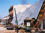
, 24 miles (39 km) east-northeast, where the earthquake's only fatalities occurred. The Acorn Building, an unreinforced masonry building
built in 1892, completely collapsed, killing two women, Jennifer Myrick and Marilyn Frost-Zafuto. Other unreinforced masonry buildings, some more than a century old, in the city's historic downtown area also had extensive damage. However, none of the buildings that had even partial retrofitting
collapsed. There was a wrongful death lawsuit filed by the relatives of the deceased women against Mary Mastagni, and several trusts which owned the Acorn Building. The jury found Mastagni negligent in the care and maintenance of the Acorn Building and awarded nearly 2 million dollars to the plaintiffs.
Two sulfur hot spring
s in Paso Robles erupted after the earthquake. One was underneath the parking lot of City Hall. Hot water and sediment
were released at a rate of about 1,300 gallons per minute (4,900 liters per minute), forming a large sinkhole
. There was formerly a bath house
at the location and the spring was capped after it closed down. Another hot spring flowed out of the embankment at the Paso Robles Street exit on U.S. Route 101.
Outside of Paso Robles the damage was less severe, with unreinforced masonry buildings taking minor to moderate damage. Buildings even 40 miles from the epicenter in San Luis Obispo
suffered minor damage such as ceiling tiles falling. Brick
veneers were also disproportionately affected. In addition, water tank
s in Paso Robles, Templeton
and Los Osos
were damaged. Residential buildings, predominantly one to two story wood frame structures, weathered the quake with little or no damage. The damage that did occur was mostly limited to chimney
s, although a house in Atascadero
suffered severe damage when it moved off its foundation. The damage was probably caused by poor construction. There were fewer nails connecting the plywood
siding to the sill than is required and many of them did not actually hit the sill. Some wineries
, especially those near the epicenter along State Route 46
, reported damage such as barrels toppling and bursting. This earthquake also damaged Mission San Miguel Arcángel
, causing $15 million worth of damage. The earthquake also caused extensive damage to George H. Flamson Middle School. The main building was damaged and had to be demolished in 2004. A new building reflecting the original 1924 building was opened for use in August 2010.
In the aftermath of the earthquake, California enacted A.B. 2533, amending the California Business and Professions Code § 8875.8, requiring that certain unreinforced masonry buildings that have not been seismically retrofitted have posted notice of the potential earthquake hazard. The law was called Jenna's Bill, after Jennifer Myrick, who died in the quake.
and San Simeon Fault zones
Earthquake
An earthquake is the result of a sudden release of energy in the Earth's crust that creates seismic waves. The seismicity, seismism or seismic activity of an area refers to the frequency, type and size of earthquakes experienced over a period of time...
on the Central Coast of California
Central Coast of California
The Central Coast is an area of California, United States, roughly spanning the area between the Monterey Bay and Point Conception. It extends through Santa Cruz County, San Benito County, Monterey County, San Luis Obispo County, and Santa Barbara County...
, about 7 miles (11.3 km) northeast of San Simeon
San Simeon, California
San Simeon is a census-designated place on the Pacific coast of San Luis Obispo County, California. Its position along State Route 1 is approximately halfway between Los Angeles and San Francisco, each of those cities being roughly 230 mi away...
. It occurred at 11:15 PST (19:15 UTC) on December 22, 2003. The earthquake probably occurred on the Oceanic fault zone in the Santa Lucia Mountains
Santa Lucia Mountains
The Santa Lucia Mountains or Santa Lucia Range is a mountain range in coastal California, running from Monterey southeast for 105 miles to San Luis Obispo. The highest summit is Junipero Serra Peak, in Monterey County...
. It was caused by reverse faulting and propagated southeast from the hypocenter
Hypocenter
The hypocenter refers to the site of an earthquake or a nuclear explosion...
for 12 miles (19 km). The most violent ground movement occurred within 50 miles of the epicenter
Epicenter
The epicenter or epicentre is the point on the Earth's surface that is directly above the hypocenter or focus, the point where an earthquake or underground explosion originates...
, though the earthquake was felt as far away as Los Angeles
Los Angeles, California
Los Angeles , with a population at the 2010 United States Census of 3,792,621, is the most populous city in California, USA and the second most populous in the United States, after New York City. It has an area of , and is located in Southern California...
.
Damage
The area around the epicenter is sparsely populated and the most severe damage occurred in Paso RoblesPaso Robles, California
Paso Robles is a city in San Luis Obispo County, California, United States. Paso Robles is the fastest growing city in San Luis Obispo County: Its population at the 2000 census was 24,297; in 2010 it recorded some 29,793 residentsLocated on the Salinas River north of San Luis Obispo, California,...
, 24 miles (39 km) east-northeast, where the earthquake's only fatalities occurred. The Acorn Building, an unreinforced masonry building
Unreinforced masonry building
An Unreinforced masonry building is a type of building where load bearing walls, non-load bearing walls or other structures, such as chimneys are made of brick, cinderblock, tiles, adobe or other masonry material, that is not braced by reinforcing beams...
built in 1892, completely collapsed, killing two women, Jennifer Myrick and Marilyn Frost-Zafuto. Other unreinforced masonry buildings, some more than a century old, in the city's historic downtown area also had extensive damage. However, none of the buildings that had even partial retrofitting
Seismic retrofit
Seismic retrofitting is the modification of existing structures to make them more resistant to seismic activity, ground motion, or soil failure due to earthquakes. With better understanding of seismic demand on structures and with our recent experiences with large earthquakes near urban centers,...
collapsed. There was a wrongful death lawsuit filed by the relatives of the deceased women against Mary Mastagni, and several trusts which owned the Acorn Building. The jury found Mastagni negligent in the care and maintenance of the Acorn Building and awarded nearly 2 million dollars to the plaintiffs.
Two sulfur hot spring
Hot spring
A hot spring is a spring that is produced by the emergence of geothermally heated groundwater from the Earth's crust. There are geothermal hot springs in many locations all over the crust of the earth.-Definitions:...
s in Paso Robles erupted after the earthquake. One was underneath the parking lot of City Hall. Hot water and sediment
Sediment
Sediment is naturally occurring material that is broken down by processes of weathering and erosion, and is subsequently transported by the action of fluids such as wind, water, or ice, and/or by the force of gravity acting on the particle itself....
were released at a rate of about 1,300 gallons per minute (4,900 liters per minute), forming a large sinkhole
Sinkhole
A sinkhole, also known as a sink, shake hole, swallow hole, swallet, doline or cenote, is a natural depression or hole in the Earth's surface caused by karst processes — the chemical dissolution of carbonate rocks or suffosion processes for example in sandstone...
. There was formerly a bath house
Public bathing
Public baths originated from a communal need for cleanliness. The term public may confuse some people, as some types of public baths are restricted depending on membership, gender, religious affiliation, or other reasons. As societies have changed, public baths have been replaced as private bathing...
at the location and the spring was capped after it closed down. Another hot spring flowed out of the embankment at the Paso Robles Street exit on U.S. Route 101.
Outside of Paso Robles the damage was less severe, with unreinforced masonry buildings taking minor to moderate damage. Buildings even 40 miles from the epicenter in San Luis Obispo
San Luis Obispo, California
San Luis Obispo is a city in California, located roughly midway between San Francisco and Los Angeles on the Central Coast. Founded in 1772 by Spanish Fr. Junipero Serra, San Luis Obispo is one of California’s oldest communities...
suffered minor damage such as ceiling tiles falling. Brick
Brick
A brick is a block of ceramic material used in masonry construction, usually laid using various kinds of mortar. It has been regarded as one of the longest lasting and strongest building materials used throughout history.-History:...
veneers were also disproportionately affected. In addition, water tank
Water tank
A Water tank is a container for storing water. The need for a water tank is as old as civilized man, providing storage of water for drinking water, irrigation agriculture, fire suppression, agricultural farming, both for plants and livestock, chemical manufacturing, food preparation as well as many...
s in Paso Robles, Templeton
Templeton, California
Templeton is a census-designated place in San Luis Obispo County, California. The population was 7,674 at the 2010 census, up from 4,687 at the 2000 census.-Geography:...
and Los Osos
Los Osos, California
Los Osos is an unincorporated area and a census-designated place located along the Pacific coast of San Luis Obispo County, California. The community is part of the 93402 and 93412 ZIP Codes and area code 805. The population was 14,276 at the 2010 census....
were damaged. Residential buildings, predominantly one to two story wood frame structures, weathered the quake with little or no damage. The damage that did occur was mostly limited to chimney
Chimney
A chimney is a structure for venting hot flue gases or smoke from a boiler, stove, furnace or fireplace to the outside atmosphere. Chimneys are typically vertical, or as near as possible to vertical, to ensure that the gases flow smoothly, drawing air into the combustion in what is known as the...
s, although a house in Atascadero
Atascadero, California
Atascadero is a city in San Luis Obispo County, California, about equidistant from San Francisco and Los Angeles on U-S Highway 101. Atascadero is farther inland than most other San Luis Obispo County cities, and as a result, usually experiences warmer, drier summers and cooler winters than...
suffered severe damage when it moved off its foundation. The damage was probably caused by poor construction. There were fewer nails connecting the plywood
Plywood
Plywood is a type of manufactured timber made from thin sheets of wood veneer. It is one of the most widely used wood products. It is flexible, inexpensive, workable, re-usable, and can usually be locally manufactured...
siding to the sill than is required and many of them did not actually hit the sill. Some wineries
Winery
A winery is a building or property that produces wine, or a business involved in the production of wine, such as a wine company. Some wine companies own many wineries. Besides wine making equipment, larger wineries may also feature warehouses, bottling lines, laboratories, and large expanses of...
, especially those near the epicenter along State Route 46
California State Route 46
State Route 46 is an east–west state highway in the U.S. state of California. It is a major crossing of the Coast Ranges, connecting SR 1 on the Central Coast near Cambria and US 101 in Paso Robles with SR 99 at Famoso in the San Joaquin Valley. East of Paso Robles, where it carried U.S...
, reported damage such as barrels toppling and bursting. This earthquake also damaged Mission San Miguel Arcángel
Mission San Miguel Arcángel
Mission San Miguel Arcángel was founded on July 25, 1797 by the Franciscan order, on a site chosen specifically due to the large number of Salinan Indians that inhabited the area, whom the Spanish priests wanted to evangelize. It is located at 775 Mission Street, San Miguel, in San Luis Obispo...
, causing $15 million worth of damage. The earthquake also caused extensive damage to George H. Flamson Middle School. The main building was damaged and had to be demolished in 2004. A new building reflecting the original 1924 building was opened for use in August 2010.
In the aftermath of the earthquake, California enacted A.B. 2533, amending the California Business and Professions Code § 8875.8, requiring that certain unreinforced masonry buildings that have not been seismically retrofitted have posted notice of the potential earthquake hazard. The law was called Jenna's Bill, after Jennifer Myrick, who died in the quake.
Seismology
The area where the quake struck displays complex faulting, between the Oceanic Fault and Nacimiento Fault zones, along with possible interaction from the Hosgri faultHosgri fault
The Hosgri Fault is an offshore fault zone located near the Central Coast of California in San Luis Obispo County. The main fault stretches for about , and the coastal communities closest to it are Cambria, San Simeon and Morro Bay, Baywood Park-Los Osos, and Avila Beach...
and San Simeon Fault zones