
California State Route 46
Encyclopedia
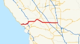
State Route 46 is an east–west state highway
in the U.S. state
of California
. It is a major crossing of the Coast Ranges, connecting SR 1 on the Central Coast near Cambria and US 101 in Paso Robles with SR 99 at Famoso in the San Joaquin Valley
. East of Paso Robles, where it carried U.S. Route 466 until 1964, SR 46 is part of the California Freeway and Expressway System
, though it is mostly a two-lane highway. The highway from SR 1 to SR 41 near Cholame is an eligible State Scenic Highway, but has not been designated as such.
The road that is now SR 46 was built and improved during the 1920s and was fully paved by 1930. The majority of SR 46 was originally designated as U.S. Route 466
; however, after the latter was entirely removed from the U.S. Highway system, the eastern portion of the route became SR 46.
. It heads east as the Eric Seastrand Highway across the Santa Lucia Range on a relatively straight roadway built in the 1970s, bypassing the steep, curvy Santa Rosa Creek Road. After passing near a few wineries, this first segment ends at US 101 north of Templeton, where SR 46 turns north, overlapping the US 101 freeway through the valley formed by the Salinas River
to central Paso Robles. Immediately after splitting from US 101, SR 46 crosses the Salinas River, passing near the Paso Robles Municipal Airport
, and then heads east through a hilly area with several wineries and the community of Whitley Gardens
. It then runs partially alongside the Estrella River
to a merge with SR 41 near Shandon and a rest area
. There, it turns northeast, following Cholame Creek through Cholame Pass between the Cholame Hills
and Temblor Range
to the settlement of Cholame and the split with SR 41. After crossing into Kern County
, the highway continues to rise as it heads east up the Antelope Grade to a summit near Bluestone Ridge before descending through Polonio Pass into the Antelope Valley, an arm of the San Joaquin Valley
.
 The two-lane stretch from Paso Robles to Cholame was once known as "Blood Alley" for the large number of crashes, mainly head-on collision
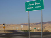
s, among the high volume of commuters, truckers, and tourists. The east end of this portion, at the SR 41 split, is where 24-year-old James Dean
died in 1955; the intersection is now marked as the James Dean Memorial Junction. The California Department of Transportation
(Caltrans) carried out an interim safety project in December 1995, mandating daytime headlights and installing thermoplastic striping and rumble strip
s. Present plans are to widen the road to a four-lane divided
expressway
.
Once it enters the San Joaquin Valley, SR 46, known as the Paso Robles Highway, follows an almost perfectly straight eastward alignment, crossing SR 33 at Blackwells Corner
, passing through the Lost Hills Oil Field
, and intersecting I-5 about two miles (3 km) past Lost Hills and the crossing of the California Aqueduct
. SR 46 then passes through the Semitropic Oil Field
about seven miles west of Wasco
. SR 46 and SR 43 overlap for a short distance in the city of Wasco, and then SR 46 passes over Calloway Canal and Friant Canal before it ends at SR 99 in Famoso. The county-maintained Famoso Road continues east across SR 65 and into the Sierra Nevada foothills.
trunk (Route 4, now SR 99) near Bakersfield with the coast trunk (Route 2, now US 101) in Paso Robles, passing through the Coast Ranges via Cholame Pass. The road was not yet built in 1919, when the Automobile Blue Book recommended only the county-maintained "very poor road" (now SR 58) via Simmler as a connection between the valley and Central Coast. By 1925, the Cholame Pass highway had been improved, and paving was completed in December 1930. An extension west to Route 56 (now SR 1) near Cambria was added in 1933; however, it ran along Santa Rosa Creek Road, north of today's alignment.
The state sign route system was established in 1934, but the majority of Route 33 did not receive a state route designation, instead becoming part of the new U.S. Route 466. However, US 466 turned southwest from Cholame Pass along Legislative Route 125 (modern SR 41) to Morro Bay. Sign Route 41, which followed Legislative Route 125 northeast of Cholame, continued along Route 33 west to the coast. However, Route 125 had still not been paved between Cholame and Atascadero by the 1950s, and so US 466 was moved to the longer but better-quality Route 33 via Paso Robles, replacing SR 41 to Paso Robles and overlapping US 101 to Atascadero. As SR 41 had not been signed over the unpaved road west of Paso Robles, it was truncated to Cholame. US 466 was eliminated in the 1964 renumbering, becoming SR 46 east from Paso Robles. However, instead of going south and west to Morro Bay, SR 46 continued west to Cambria, and the road via Creston and Atascadero to Morro Bay (which had since been paved) became part of SR 41. A new two-lane expressway
carrying SR 46 west from Paso Robles was built in the mid-1970s, replacing Santa Rosa Creek Road.
{| class=wikitable
!County
!Location
!Postmile
!Exit
!Destinations
!Notes
|-
|rowspan=11|San Luis Obispo
SLO R0.15-60.85
|
|R0.15
|
|, Hearst Castle
, Cayucos
, Morro Bay
|
|-
|rowspan=8|Paso Robles
|bgcolor=#ddffdd|R21.97
54.12Indicates that the postmile represents the distance along US 101 rather than SR 46.
|bgcolor=#ddffdd|
|bgcolor=#ddffdd|
|bgcolor=#ddffdd|Interchange; west end of US 101 overlap
|-
|colspan=4 align=center|West end of freeway on US 101
|-bgcolor=#ffdddd
|55.67
|229
|Spring Street (US 101 Bus. north)
|Eastbound exit and westbound entrance
|-bgcolor=#ffdddd
|
|230
|Pine Street
|Westbound exit and entrance
|-bgcolor=#ffdddd
|
|230
|Paso Robles Street
|Eastbound exit only
|-bgcolor=#ffdddd
|56.88
|231A
|16th Street
|Westbound exit and eastbound entrance
|-
|colspan=4 align=center|East end of freeway on US 101
|-bgcolor=#ddffdd
|57.92
29.76
|
| – Nacimiento Lake
|Interchange; east end of US 101 overlap
|-
|Shandon
|bgcolor=#ddffdd|48.63
|bgcolor=#ddffdd|
|bgcolor=#ddffdd|
|bgcolor=#ddffdd|West end of SR 41 overlap; former US 466 west
|-
|Cholame
|bgcolor=#ddffdd|55.11
|bgcolor=#ddffdd|
|bgcolor=#ddffdd|
|bgcolor=#ddffdd|East end of SR 41 overlap
|-
|rowspan=7|Kern
KER 0.00-57.79
|Blackwells Corner
|20.54
|
|
|
|-
|
|27.48
|
|Brown Material Road, Halloway Road
|
|-
|Lost Hills
|32.53
|
|
|Interchange
|-
|
|43.02
|
|Rowlee Road – Buttonwillow
|
|-
|rowspan=2|Wasco
|bgcolor=#ddffdd|50.90
|bgcolor=#ddffdd|
|bgcolor=#ddffdd|, Central District
|bgcolor=#ddffdd|West end of SR 43 overlap
|-bgcolor=#ddffdd
|51.22
|
|
|East end of SR 43 overlap
|-
|Famoso
|57.79
|
|
|Interchange; former US 99 / US 466 east
State highway
State highway, state road or state route can refer to one of three related concepts, two of them related to a state or provincial government in a country that is divided into states or provinces :#A...
in the U.S. state
U.S. state
A U.S. state is any one of the 50 federated states of the United States of America that share sovereignty with the federal government. Because of this shared sovereignty, an American is a citizen both of the federal entity and of his or her state of domicile. Four states use the official title of...
of California
California
California is a state located on the West Coast of the United States. It is by far the most populous U.S. state, and the third-largest by land area...
. It is a major crossing of the Coast Ranges, connecting SR 1 on the Central Coast near Cambria and US 101 in Paso Robles with SR 99 at Famoso in the San Joaquin Valley
San Joaquin Valley
The San Joaquin Valley is the area of the Central Valley of California that lies south of the Sacramento – San Joaquin River Delta in Stockton...
. East of Paso Robles, where it carried U.S. Route 466 until 1964, SR 46 is part of the California Freeway and Expressway System
California Freeway and Expressway System
The California Freeway and Expressway System is a system of existing or planned freeways and expressways in the U.S. state of California. It is defined by the Streets and Highways Code.-List of roads in the system:*State Route 1 *State Route 2...
, though it is mostly a two-lane highway. The highway from SR 1 to SR 41 near Cholame is an eligible State Scenic Highway, but has not been designated as such.
The road that is now SR 46 was built and improved during the 1920s and was fully paved by 1930. The majority of SR 46 was originally designated as U.S. Route 466
U.S. Route 466
U.S. Route 466 was an east–west United States highway. Though it reached a length of around 500 miles , the route was co-signed with other US routes for much of its length. When California deleted most of its U.S...
; however, after the latter was entirely removed from the U.S. Highway system, the eastern portion of the route became SR 46.
Route description
State Route 46 begins at SR 1 southeast of Cambria, about one mile (2 km) from the Pacific OceanPacific Ocean
The Pacific Ocean is the largest of the Earth's oceanic divisions. It extends from the Arctic in the north to the Southern Ocean in the south, bounded by Asia and Australia in the west, and the Americas in the east.At 165.2 million square kilometres in area, this largest division of the World...
. It heads east as the Eric Seastrand Highway across the Santa Lucia Range on a relatively straight roadway built in the 1970s, bypassing the steep, curvy Santa Rosa Creek Road. After passing near a few wineries, this first segment ends at US 101 north of Templeton, where SR 46 turns north, overlapping the US 101 freeway through the valley formed by the Salinas River
Salinas River (California)
The Salinas River is the largest river of the central coast of California, running and draining 4,160 square miles. It flows north-northwest and drains the Salinas Valley that slices through the Coast Range south from Monterey Bay...
to central Paso Robles. Immediately after splitting from US 101, SR 46 crosses the Salinas River, passing near the Paso Robles Municipal Airport
Paso Robles Municipal Airport
Paso Robles Municipal Airport is a public airport located four miles northeast of the central business district of Paso Robles, a city in San Luis Obispo County, California, United States...
, and then heads east through a hilly area with several wineries and the community of Whitley Gardens
Whitley Gardens, California
Whitley Gardens is a census-designated place in San Luis Obispo County, California. Whitley Gardens sits at an elevation of . The 2010 United States census reported Whitley Gardens's population was 285.-Geography:...
. It then runs partially alongside the Estrella River
Estrella River
The Estrella River is a river in eastern San Luis Obispo County, California. The river forms at the confluence of Cholame Creek, from the north, and San Juan Creek, from the south, near the town of Shandon...
to a merge with SR 41 near Shandon and a rest area
Rest area
A rest area, travel plaza, rest stop, or service area is a public facility, located next to a large thoroughfare such as a highway, expressway, or freeway at which drivers and passengers can rest, eat, or refuel without exiting on to secondary roads...
. There, it turns northeast, following Cholame Creek through Cholame Pass between the Cholame Hills
Cholame Hills
The Cholame Hills are a low mountain range, in the California Coast Ranges, in extreme southeastern Monterey County, California....
and Temblor Range
Temblor Range
The Temblor Range is a mountain range within the California Coast Ranges, at the southwestern extremity of the San Joaquin Valley in California in the United States. It runs in a northwest-southeasterly direction along the borders of Kern County and San Luis Obispo County. The name of the range is...
to the settlement of Cholame and the split with SR 41. After crossing into Kern County
Kern County, California
Spreading across the southern end of the California Central Valley, Kern County is the fifth-largest county by population in California. Its economy is heavily linked to agriculture and to petroleum extraction, and there is a strong aviation and space presence. Politically, it has generally...
, the highway continues to rise as it heads east up the Antelope Grade to a summit near Bluestone Ridge before descending through Polonio Pass into the Antelope Valley, an arm of the San Joaquin Valley
San Joaquin Valley
The San Joaquin Valley is the area of the Central Valley of California that lies south of the Sacramento – San Joaquin River Delta in Stockton...
.
Head-on collision
A head-on collision is one where the front ends of two ships, trains, planes or vehicles hit each other, as opposed to a side collision or rear-end collision.-Rail transport:...
s, among the high volume of commuters, truckers, and tourists. The east end of this portion, at the SR 41 split, is where 24-year-old James Dean
James Dean
James Byron Dean was an American film actor. He is a cultural icon, best embodied in the title of his most celebrated film, Rebel Without a Cause , in which he starred as troubled Los Angeles teenager Jim Stark...
died in 1955; the intersection is now marked as the James Dean Memorial Junction. The California Department of Transportation
California Department of Transportation
The California Department of Transportation is a government department in the U.S. state of California. Its mission is to improve mobility across the state. It manages the state highway system and is actively involved with public transportation systems throughout the state...
(Caltrans) carried out an interim safety project in December 1995, mandating daytime headlights and installing thermoplastic striping and rumble strip
Rumble strip
Rumble strips, also known as sleeper lines, are a road safety feature that alert inattentive drivers to potential danger by causing a tactile vibration and audible rumbling, transmitted through the wheels into the car body...
s. Present plans are to widen the road to a four-lane divided
Divided Highway
Divided Highway is a compilation album by American rock band The Doobie Brothers, released in 2003. . All tracks are taken from the albums Cycles and Brotherhood .-Track listing:...
expressway
Limited-access road
A limited-access road known by various terms worldwide, including limited-access highway, dual-carriageway and expressway, is a highway or arterial road for high-speed traffic which has many or most characteristics of a controlled-access highway , including limited or no access to adjacent...
.
Once it enters the San Joaquin Valley, SR 46, known as the Paso Robles Highway, follows an almost perfectly straight eastward alignment, crossing SR 33 at Blackwells Corner
Blackwells Corner, California
Blackwells Corner is an unincorporated community in Kern County, California. It is located west-northwest of Bakersfield, at an elevation of 650 feet...
, passing through the Lost Hills Oil Field
Lost Hills Oil Field
The Lost Hills Oil Field is a large oil field in the Lost Hills Range, north of the town of Lost Hills in western Kern County, California, in the United States.-Production:...
, and intersecting I-5 about two miles (3 km) past Lost Hills and the crossing of the California Aqueduct
California Aqueduct
The Governor Edmund G. Brown California Aqueduct is a system of canals, tunnels, and pipelines that conveys water collected from the Sierra Nevada Mountains and valleys of Northern- and Central California to Southern California. The Department of Water Resources operates and maintains the...
. SR 46 then passes through the Semitropic Oil Field
Semitropic Oil Field
The Semitropic Oil Field is an oil and gas field in northwestern Kern County in California in the United States, within the San Joaquin Valley. Formerly known as the Semitropic Gas Field, it was discovered by the Standard Oil Company of California in 1935, and first understood to be primarily a...
about seven miles west of Wasco
Wasco, California
Wasco is a city in the San Joaquin Valley, in Kern County, California, United States. Wasco is located northwest of Bakersfield, at an elevation of 328 feet...
. SR 46 and SR 43 overlap for a short distance in the city of Wasco, and then SR 46 passes over Calloway Canal and Friant Canal before it ends at SR 99 in Famoso. The county-maintained Famoso Road continues east across SR 65 and into the Sierra Nevada foothills.
History
As part of the second state highway bond issue, approved by the state's voters in 1916, Route 33 was created, linking the San Joaquin ValleySan Joaquin Valley
The San Joaquin Valley is the area of the Central Valley of California that lies south of the Sacramento – San Joaquin River Delta in Stockton...
trunk (Route 4, now SR 99) near Bakersfield with the coast trunk (Route 2, now US 101) in Paso Robles, passing through the Coast Ranges via Cholame Pass. The road was not yet built in 1919, when the Automobile Blue Book recommended only the county-maintained "very poor road" (now SR 58) via Simmler as a connection between the valley and Central Coast. By 1925, the Cholame Pass highway had been improved, and paving was completed in December 1930. An extension west to Route 56 (now SR 1) near Cambria was added in 1933; however, it ran along Santa Rosa Creek Road, north of today's alignment.
The state sign route system was established in 1934, but the majority of Route 33 did not receive a state route designation, instead becoming part of the new U.S. Route 466. However, US 466 turned southwest from Cholame Pass along Legislative Route 125 (modern SR 41) to Morro Bay. Sign Route 41, which followed Legislative Route 125 northeast of Cholame, continued along Route 33 west to the coast. However, Route 125 had still not been paved between Cholame and Atascadero by the 1950s, and so US 466 was moved to the longer but better-quality Route 33 via Paso Robles, replacing SR 41 to Paso Robles and overlapping US 101 to Atascadero. As SR 41 had not been signed over the unpaved road west of Paso Robles, it was truncated to Cholame. US 466 was eliminated in the 1964 renumbering, becoming SR 46 east from Paso Robles. However, instead of going south and west to Morro Bay, SR 46 continued west to Cambria, and the road via Creston and Atascadero to Morro Bay (which had since been paved) became part of SR 41. A new two-lane expressway
Limited-access road
A limited-access road known by various terms worldwide, including limited-access highway, dual-carriageway and expressway, is a highway or arterial road for high-speed traffic which has many or most characteristics of a controlled-access highway , including limited or no access to adjacent...
carrying SR 46 west from Paso Robles was built in the mid-1970s, replacing Santa Rosa Creek Road.
Major intersections
- Note: Except where prefixed with a letter, postmiles were measured in 1964, based on the alignment as it existed at that time, and do not necessarily reflect current mileage. The numbers reset at county lines; the start and end postmiles in each county are given in the county column.
{| class=wikitable
!County
!Location
!Postmile
!Exit
Exit number
An exit number is a number assigned to a road junction, usually an exit from a freeway. It is usually marked on the same sign as the destinations of the exit, as well as a sign in the gore....
!Destinations
!Notes
|-
|rowspan=11|San Luis Obispo
San Luis Obispo County, California
San Luis Obispo County is a county located along the Pacific Ocean in the Central Coast of the U.S. state of California, between Los Angeles and the San Francisco Bay Area. As of the 2010 census its population was 269,637, up from 246,681 at the 2000 census...
SLO R0.15-60.85
|
|R0.15
|
|, Hearst Castle
Hearst Castle
Hearst Castle is a National Historic Landmark mansion located on the Central Coast of California, United States. It was designed by architect Julia Morgan between 1919 and 1947 for newspaper magnate William Randolph Hearst, who died in 1951. In 1957, the Hearst Corporation donated the property to...
, Cayucos
Cayucos, California
Cayucos is a census-designated place located on the coast in San Luis Obispo County, California along California State Route 1 between Cambria to the north and Morro Bay to the south...
, Morro Bay
Morro Bay, California
Morro Bay is a waterfront city in San Luis Obispo County, California, United States. As of the 2010 census, the city population was 10,234, down from 10,350 at the 2000 census.- History :...
|
|-
|rowspan=8|Paso Robles
Paso Robles, California
Paso Robles is a city in San Luis Obispo County, California, United States. Paso Robles is the fastest growing city in San Luis Obispo County: Its population at the 2000 census was 24,297; in 2010 it recorded some 29,793 residentsLocated on the Salinas River north of San Luis Obispo, California,...
|bgcolor=#ddffdd|R21.97
54.12Indicates that the postmile represents the distance along US 101 rather than SR 46.
|bgcolor=#ddffdd|
|bgcolor=#ddffdd|
|bgcolor=#ddffdd|Interchange; west end of US 101 overlap
|-
|colspan=4 align=center|West end of freeway on US 101
|-bgcolor=#ffdddd
|55.67
|229
|Spring Street (US 101 Bus. north)
|Eastbound exit and westbound entrance
|-bgcolor=#ffdddd
|
|230
|Pine Street
|Westbound exit and entrance
|-bgcolor=#ffdddd
|
|230
|Paso Robles Street
|Eastbound exit only
|-bgcolor=#ffdddd
|56.88
|231A
|16th Street
|Westbound exit and eastbound entrance
|-
|colspan=4 align=center|East end of freeway on US 101
|-bgcolor=#ddffdd
|57.92
29.76
|
| – Nacimiento Lake
|Interchange; east end of US 101 overlap
|-
|Shandon
Shandon, California
Shandon is a census-designated place in San Luis Obispo County, California, United States. The population was 1,295 at the 2010 census, up from 986 at the 2000 census.-Setting:...
|bgcolor=#ddffdd|48.63
|bgcolor=#ddffdd|
|bgcolor=#ddffdd|
|bgcolor=#ddffdd|West end of SR 41 overlap; former US 466 west
|-
|Cholame
Cholame, California
Cholame, California is an unincorporated community in San Luis Obispo County, California, USA. It sits within a mile of the San Andreas Rift Zone fault line at an elevation of 1,157 feet above sea level and is located at . Cholame is reached via State Route 41, just southwest of the junction of...
|bgcolor=#ddffdd|55.11
|bgcolor=#ddffdd|
|bgcolor=#ddffdd|
|bgcolor=#ddffdd|East end of SR 41 overlap
|-
|rowspan=7|Kern
Kern County, California
Spreading across the southern end of the California Central Valley, Kern County is the fifth-largest county by population in California. Its economy is heavily linked to agriculture and to petroleum extraction, and there is a strong aviation and space presence. Politically, it has generally...
KER 0.00-57.79
|Blackwells Corner
Blackwells Corner, California
Blackwells Corner is an unincorporated community in Kern County, California. It is located west-northwest of Bakersfield, at an elevation of 650 feet...
|20.54
|
|
|
|-
|
|27.48
|
|Brown Material Road, Halloway Road
|
|-
|Lost Hills
Lost Hills, California
Lost Hills is a census-designated place in Kern County, California, United States. Lost Hills is located west-northwest of Bakersfield, at an elevation of 305 feet...
|32.53
|
|
|Interchange
|-
|
|43.02
|
|Rowlee Road – Buttonwillow
Buttonwillow, California
Buttonwillow is a census-designated place in the San Joaquin Valley, in Kern County, California, United States. Buttonwilliow is located west of Bakersfield, at an elevation of 269 feet . The population was 1,508 at the 2010 census, up from 1,266 at the 2000 census...
|
|-
|rowspan=2|Wasco
Wasco, California
Wasco is a city in the San Joaquin Valley, in Kern County, California, United States. Wasco is located northwest of Bakersfield, at an elevation of 328 feet...
|bgcolor=#ddffdd|50.90
|bgcolor=#ddffdd|
|bgcolor=#ddffdd|, Central District
Wasco, California
Wasco is a city in the San Joaquin Valley, in Kern County, California, United States. Wasco is located northwest of Bakersfield, at an elevation of 328 feet...
|bgcolor=#ddffdd|West end of SR 43 overlap
|-bgcolor=#ddffdd
|51.22
|
|
|East end of SR 43 overlap
|-
|Famoso
Famoso, California
Famoso is an unincorporated community in Kern County, California. It is located on Poso Creek south-southeast of McFarland, at an elevation of 427 feet ....
|57.79
|
|
|Interchange; former US 99 / US 466 east