

San Andrés y Sauces
Encyclopedia
| San Andrés y Sauces | |
| Map | |
|---|---|
 |
|
| Statistics | |
| Autonomous region: | Canary Islands Canary Islands The Canary Islands , also known as the Canaries , is a Spanish archipelago located just off the northwest coast of mainland Africa, 100 km west of the border between Morocco and the Western Sahara. The Canaries are a Spanish autonomous community and an outermost region of the European Union... |
| Province: | Santa Cruz de Tenerife Santa Cruz de Tenerife (province) Province of Santa Cruz de Tenerife also Province of Santa Cruz is a province of Spain, consisting of the western part of the autonomous community of the Canary Islands. It consists of about half of the Atlantic archipelago, including the islands of Tenerife, La Gomera, El Hierro, and La Palma, and... |
| Island: | La Palma La Palma La Palma is the most north-westerly of the Canary Islands. La Palma has an area of 706 km2 making it the fifth largest of the seven main Canary Islands... |
| Area Area Area is a quantity that expresses the extent of a two-dimensional surface or shape in the plane. Area can be understood as the amount of material with a given thickness that would be necessary to fashion a model of the shape, or the amount of paint necessary to cover the surface with a single coat... : |
42.02 km² |
| Population Population A population is all the organisms that both belong to the same group or species and live in the same geographical area. The area that is used to define a sexual population is such that inter-breeding is possible between any pair within the area and more probable than cross-breeding with individuals... : |
5,012 (2001) |
| Population density Population density Population density is a measurement of population per unit area or unit volume. It is frequently applied to living organisms, and particularly to humans... : |
119.28/km² |
| Length of coastline | 5.55 km |
| Elevation Elevation The elevation of a geographic location is its height above a fixed reference point, most commonly a reference geoid, a mathematical model of the Earth's sea level as an equipotential gravitational surface .... : Lowest: Centre: Highest: |
Atlantic Ocean Atlantic Ocean The Atlantic Ocean is the second-largest of the world's oceanic divisions. With a total area of about , it covers approximately 20% of the Earth's surface and about 26% of its water surface area... 250 m near Caldera do Taburiente |
| Postal code: | E-38720 |
| Location Geographic coordinate system A geographic coordinate system is a coordinate system that enables every location on the Earth to be specified by a set of numbers. The coordinates are often chosen such that one of the numbers represent vertical position, and two or three of the numbers represent horizontal position... : |
28.8/28°48' N lat. 17.7667/17°46' W long. |
| Municipal code: | E-38033 |
| Car designation: | TF |
| Politics | |
| Mayor Mayor In many countries, a Mayor is the highest ranking officer in the municipal government of a town or a large urban city.... : |
Nieves María Dávila Martín (CC Canarian Coalition The Canarian Coalition , abbreviated to CC, is a Canarian nationalist and liberal political party in the Canary Islands of Spain. The party aim is for greater autonomy for the islands, but short of independence. The party has governed the Canary Islands since 1993... ) 1st term |
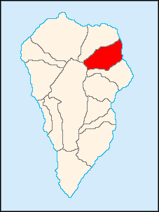
San Andrés y Sauces (first part, Spanish
Spanish language
Spanish , also known as Castilian , is a Romance language in the Ibero-Romance group that evolved from several languages and dialects in central-northern Iberia around the 9th century and gradually spread with the expansion of the Kingdom of Castile into central and southern Iberia during the...
for Saint Andrew
Saint Andrew
Saint Andrew , called in the Orthodox tradition Prōtoklētos, or the First-called, is a Christian Apostle and the brother of Saint Peter. The name "Andrew" , like other Greek names, appears to have been common among the Jews from the 3rd or 2nd century BC. No Hebrew or Aramaic name is recorded for him...
) is located on the eastern part of the island of La Palma
La Palma
La Palma is the most north-westerly of the Canary Islands. La Palma has an area of 706 km2 making it the fifth largest of the seven main Canary Islands...
in the province of Santa Cruz de Tenerife
Santa Cruz de Tenerife
Santa Cruz de Tenerife is the capital , second-most populous city of the Autonomous Community of the Canary Islands and the 21st largest city in Spain, with a population of 222,417 in 2009...
of the Canary Islands
Canary Islands
The Canary Islands , also known as the Canaries , is a Spanish archipelago located just off the northwest coast of mainland Africa, 100 km west of the border between Morocco and the Western Sahara. The Canaries are a Spanish autonomous community and an outermost region of the European Union...
. San Andrés y Sauces is linked with a main highway encircling every part of the island and is located north of the La Palma Airport.
The population is 5,102 (ISTAC, 2004), its density is 222.17/km² and the area is 30.82 km²/3,082 ha. The elevation is 250 m at Los Sauces.
Farmlands dominate the eastern part as well as the coastline, forests dominate the western and most of the central parts as well as mountains to the west. The majority of the population are rural and a few are urban.
During those times, the municipality were divided into two towns San Andrés by the coastline and Los Sauces inland. During the sugar cane crisis, the population slightly declined and finally, they united due to the crossing of a main road to the north. Los Sauces' population grew, while San Andrés' population were stabilized or slightlly decline.
The municipality is rich in laurisilva
Laurisilva
Laurisilva or laurissilva is a subtropical forest, found in areas with high humidity and relatively stable and mild temperatures. They are characterised by evergreen, glossy-leaved tree species that look alike with leaves of lauroide type...
forests and includes many banana plantations. The sites of interests includes the forest of Los Tilos located west of San Andrés, which is one the best preserved laurisilva forest of the Canary Islands, as well as settlements where buildings are rich in traditional architecture, mainly in San Andrés.
The economy is based on agriculture and tourism. In regasrd to agriculture, banana remains as the overwhelming crop, leading the municipality's fruit exports. Another very relevant crop is the here so-called "ñame", which is the internationally named taro
Taro
Taro is a common name for the corms and tubers of several plants in the family Araceae . Of these, Colocasia esculenta is the most widely cultivated, and is the subject of this article. More specifically, this article describes the 'dasheen' form of taro; another variety is called eddoe.Taro is...
(Colocasia esculenta). This is a very autochthonous crop, although its real origin is located in Southeast Asia. It is believed that it came from there crossing through South Asia, Middle East and North Africa. It's a tubercule, and requires a land that must be always wet, demanding a continuous flow of water to grow. Sand Andrés y Sauces' large water resources are the reason for the success of that crop in this area. Other minor cultivation is sugar cane, which serves for the only distillery in the land that manufactures Ron Aldea, a rum
Rum
Rum is a distilled alcoholic beverage made from sugarcane by-products such as molasses, or directly from sugarcane juice, by a process of fermentation and distillation. The distillate, a clear liquid, is then usually aged in oak barrels...
.
By the coast features Puerto Spíndola, a small fishing port that was previously the main way of communications in the municipality until the highway constructed in the 20th century. Also by the coast is a small touristic centre of San Andrés y Sauces, a pool named Charco Azul.
Historical population
| Year | Population | Change | Density |
|---|---|---|---|
| 1991 | 5,392 | - | - |
| 1996 | 5,438 | - | - |
| 2001 | 5,351 | - | 124.44/km² |
| 2002 | 5,226 | - | - |
| 2003 | 5,102 | - | 119.35/km² |
| 2004 | 5,012 | - | 119.28/km² |
The population between 1996 and 1997 grew but in the 2001 to 2004 censuses, the population reported a slight decline.
Other
San Andrés y Sauces has schools, a few lyceums, a gymnasium, churches, a small beach, a small port, a post office and a few squares plazaPlaza
Plaza is a Spanish word related to "field" which describes an open urban public space, such as a city square. All through Spanish America, the plaza mayor of each center of administration held three closely related institutions: the cathedral, the cabildo or administrative center, which might be...
s.
External links
- Map and aerial photos
- Street map: Street map from Mapquest, MapPoint or Google
- Satellite images: Google
- Coordinates: 28°41′0"N 17°46′0"W
See also
- La GomeraLa GomeraLa Gomera is one of Spain's Canary Islands, located in the Atlantic Ocean off the coast of Africa. In area, it is the second-smallest of the seven main islands of this group.- Political organization :...
- List of municipalities in Santa Cruz de Tenerife