
La Palma
Encyclopedia
La Palma is the most north-westerly of the Canary Islands
. La Palma has an area of 706 km2 making it the fifth largest of the seven main Canary Islands. The total population is about 86,000, of which 18,000 (2003 data) live in the capital, Santa Cruz de la Palma
and about 20,000 (2004 data) in Los Llanos de Aridane.
Santa Cruz de La Palma (the island's main port) retains many elegant 17th and 18th century houses, and produces high quality hand made cigars made from locally grown tobacco.
In 1815, the German geologist Leopold von Buch visited the Canary Islands. It was as a result of his visit to La Palma and Tenerife where he visited the Las Cañadas and Taburiente calderas, that the Spanish word for cauldron - "Caldera
" - was introduced into the English language geological vocabulary.
. There is road access from sea level to the summit at 2,423 m, which is marked by an outcrop of rocks called Los Muchachos ("The Lads"). This is the site of the Roque de los Muchachos Observatory
, one of the world's premier astronomical observatories.
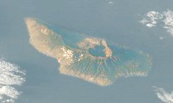
La Palma's geography is a result of the volcanic
formation of the island. The highest peaks reach over 2400 m (7,874 ft) above sea level, and the base of the island is located almost 4000 meters below sea level. The northern part of La Palma is dominated by the Caldera de Taburiente, with a width of 9 km (6 mi) and a depth of 1500 m (4,921 ft). It is surrounded by a ring of mountains ranging from 1600 m (5,249 ft) to 2400 m (7,874 ft) in height. Only the deep Barranco de las Angustias ("Canyon of Anxiety") canyon leads into the inner area of the caldera which is a national park. It can be reached only by hiking. The outer slopes are cut by numerous gorges which run from 2000 m (6,562 ft) down to the sea. Today, only few of these carry water due to the many water tunnels that have been cut into the islands structure.
From the Caldera de Taburiente to the south runs the ridge Cumbre Nueva. The southern part of La Palma is dominated by the Cumbre Vieja
, a volcanic ridge formed by numerous volcanic cones built of lava and scoria. The Cumbre Vieja is active - but dormant, with the last eruption occurring in 1971 at the Teneguia
vent which is located at the southern end of the Cumbre Vieja - Punta de Fuencaliente, (The Point of the Hot Fountain).
La Palma has abundant plant life (which is the most diverse in the Canary Islands).
". San Pedro is also a music venue on the island where international bands play.
.
The island is divided into 14 municipalities:
 Like all of the Canary Islands
, La Palma originally formed as a seamount
through submarine volcanic activity. La Palma is currently the most volcanically active of the Canary Islands and was formed three to four million years ago. Its base lies almost 4,000 metres below sea level and reaches a height of 2,426 metres above sea level. About a half a million years ago, the volcano, Taburiente, collapsed with a giant landslide, forming the Caldera de Taburiente. Since the Spanish occupation, there have been seven eruptions:
During the 1949 eruption from the Duraznero, San Juan, and Hoyo Negro vents on the Cumbre Vieja
, an earthquake, with an epicentre near Jedy, occurred. This caused a 2.5 kilometre-long rift to open, with a width of about a metre and a depth of about two metres (Rubio Bonelli, 1950).
Fisherman operating from Santa Cruz, Tazacorte and Puerto Naos catch fish for the local markets.
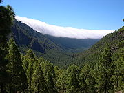
Although large areas have been deforested, the upland areas of La Palma retain some of the temperate cloud forest
, or laurisilva
(laurel forest), dominated by Laurus
, but including Juniperus cedrus
(Canary Islands Juniper) and other trees. This is a relic of the Pliocene
subtropical forests which used to cover all the Canary Islands.
The Canary Island Pine
(Pinus canariensis) is endemic to all the Western Canary Islands, whilst Genista stenopetala
, or sweet broom and Spartocytisus supranubius
, a white broom known locally as Retama del Teide, are native to La Palma and Tenerife.
Echium webbii, a variety of Echium virescens
(Tower of jewels) is endemic to La Palma, as are Ceropegia fusca
and Ceropegia dichotoma
; varieties of Cardoncillo.
Several animals are native or endemic to La Palma, including the:
In addition, many other animals have been introduced, including rabbits and Barbary Sheep
, or Aoudads, which have become a serious threat to endemic flora
A biosphere reserve was established in 1983, and extended and renamed in 1997 and 2002
, although the natives of La Palma are more correctly known as Auaritas (See Canary Islands in pre-colonial times
). The origin of these natives is unclear but they are believed to share common ancestry with the Berbers
of North Africa. The Guanches had a Neolithic culture divided into several clans led by chiefs. Their name for La Palma was Benahoare
. The main remnants of this culture are their cave dwellings, enigmatic petroglyph
s and paved stone paths through the mountains. After the Spanish occupation of La Palma, the native Canarians vanished by either being killed, sold into slavery or by assimilating into the Spanish population.
It is believed that the Canary Islands
were known to the Phoenicians and Greeks
, but the earliest written evidence is by the Roman
writer Pliny The Elder
, who quoted Juba II
of Numidia
, but Juba's writings were subsequently lost. The Genoese
navigator Lancelotto Malocello
reached the archipelago in 1312 and remained for two decades until expelled by a native uprising. In 1404 the Spaniards began the conquest of the islands. Though the first landing on La Palma was in 1405, it took until 1493 and several bloody battles until the last resistance of the natives was broken. The conqueror of La Palma was Alonso Fernández de Lugo
, who defeated Tanausu
, the last king on the island. He ruled the area known as Acero (Caldera de Taburiente). Tanausu was ambushed after agreeing to a truce arranged by Fernández de Lugo and Juan de Palma, a Guanche who had converted to Christianity
and who was a relative of Tanausu.
For the next two centuries, settlements on La Palma became rich as the island served as a trading post on the way to the New World
. La Palma received immigrants from Castile
, Portugal
, Majorca, Flanders
, and Catalonia
.
Each island has a patron saint and "Virgen de las Nieves" (The virgin of the snow) is the patron saint of La Palma. Many women on the island have the name "Nieves" in honor of this.
There is a road that runs from Los Llanos de Aridane to the capital city of the island Santa Cruz de La Palma (known by locals as simply La Palma). This road is a two lane highway that includes a two lane tunnel that goes right through the top of the mountain. When traveling from one side of the mountain to the other it is common to enter one side in complete clouds (the east side) and come out to the sunny side (western side). This is due to the clouds not being able to cross the mountains.
La Palma Airport
serves the island, and several airlines run services to and from it. There is also ferry service to and from the island in the city of Sta. Cruz.
at 1200–1600 m altitude, carried on the prevailing wind which blows from the north-east Trade Winds. The water condenses on the long needles of the trees and other vegetation, it then either drips onto the ground or runs down the trunk etc., into the ground. Eventually it collects inside the rock-strata, and is then drained via the galerias into aqueducts and pipes for distribution. The galerias have been cut into the rocks over centuries. To visit the galerias a permit is required. It is possible to walk alongside many of the aqueducts, a popular activity for tourists (similar to the levada
s of Madeira
). The tour to the Marcos y Corderos waterfall and springs is also popular.
There is an extensive network of irrigation canals in the valley of Los Llanos de Aridane. These canals carry water from the mountains throughout the valley and allow for the cultivation of bananas, avocados, flowers, and other plants. Each farmer gets a scheduled "turn" to fill an irrigation tank with water 24 hours of the day. If a farmer's turn is at 2 AM he will wake up and make sure to fill his tank when possible so as to have sufficient water for his farm.
These round tanks typically gather moss and lilly pads upon which frogs make their habitat.
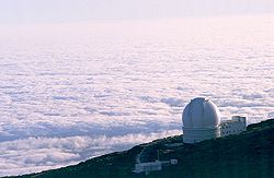
Due to the location of the island and the height of its mountains, some 2400 m (7,874 ft) above sea level, a number of international observatories
have been built on the Roque de los Muchachos
. The particular geographical position and climate cause cloud
s to form between 1000 m (3,281 ft) and 2000 m (6,562 ft), usually leaving the observatories with a clear sky. Often, the view from the top of the volcano is a sea of clouds covering the eastern part of the island. Telescopes at the observatory include:
The DOT and the SST have been specifically built to study the Sun
.
Horizon programme broadcast on October 12, 2000, two geologists (Day and McGuire) cited this rift as proof that half of the Cumbre Vieja had slipped towards the Atlantic Ocean
(Day et al., 1999; Ward and Day, 2001). They suggested that this process was driven by the pressure caused by the rising magma
heating water trapped within the structure of the island. They hypothesised that during a future eruption, the western flank of the Cumbre Vieja
, with a mass of approximately 1.5 x10¹⁵ kg, could slide into the ocean. This could then potentially generate a giant wave which they termed a "megatsunami
" around 650–900 m high in the region of the islands. The wave would radiate out across the Atlantic and inundate the eastern seaboard of North America including the American
, the Caribbean
and northern coasts of South America some six to eight hours later. They estimate that the tsunami will have waves possibly 160 ft (49 m) or more high causing massive devastation along the coastlines. Modelling suggests that the tsunami could inundate up to 25 km (16 mi) inland - depending upon topography. The basis for Ward and Day (1999) modelling the collapse of a much larger portion of the western flank than the currently visible surface fissures suggest is unstable, was based on geological mapping by Day et al. 1999. In this paper they argue that a large part of the western flank has been constructed in the scar of a previous collapse and therefore sits upon unstable debris.
The claim also was explored in a BBC docu-drama called End Day
which went through several hypothetical scenarios of disastrous proportions.
However, the Tsunami Society
(Pararas-Carayannis, 2002), published a statement stating "... We would like to halt the scaremongering from these unfounded reports..." The major points raised in this report include:
In 2006 professor Jan Nieuwenhuis of Delft University of Technology
simulated several volcanic eruptions and calculated it would take another 10,000 years for the flanks to become sufficiently high and unstable to cause a massive collapse.
An underwater volcano that began in September of 2011 south of the island gave rise to more speculation about the possibility of a megatsunami.
Canary Islands
The Canary Islands , also known as the Canaries , is a Spanish archipelago located just off the northwest coast of mainland Africa, 100 km west of the border between Morocco and the Western Sahara. The Canaries are a Spanish autonomous community and an outermost region of the European Union...
. La Palma has an area of 706 km2 making it the fifth largest of the seven main Canary Islands. The total population is about 86,000, of which 18,000 (2003 data) live in the capital, Santa Cruz de la Palma
Santa Cruz de La Palma
Santa Cruz de la Palma is located on the eastern part of the island of La Palma in the province of Santa Cruz de Tenerife of the Canary Islands. Santa Cruz de la Palma is the second largest city and is the capital of the island...
and about 20,000 (2004 data) in Los Llanos de Aridane.
Santa Cruz de La Palma (the island's main port) retains many elegant 17th and 18th century houses, and produces high quality hand made cigars made from locally grown tobacco.
In 1815, the German geologist Leopold von Buch visited the Canary Islands. It was as a result of his visit to La Palma and Tenerife where he visited the Las Cañadas and Taburiente calderas, that the Spanish word for cauldron - "Caldera
Caldera
A caldera is a cauldron-like volcanic feature usually formed by the collapse of land following a volcanic eruption, such as the one at Yellowstone National Park in the US. They are sometimes confused with volcanic craters...
" - was introduced into the English language geological vocabulary.
Origins and geology
La Palma, like the other islands of the Canary Island archipelago, is a volcanic ocean island. The volcano rises almost 7 km (4 mi) above the floor of the Atlantic OceanAtlantic Ocean
The Atlantic Ocean is the second-largest of the world's oceanic divisions. With a total area of about , it covers approximately 20% of the Earth's surface and about 26% of its water surface area...
. There is road access from sea level to the summit at 2,423 m, which is marked by an outcrop of rocks called Los Muchachos ("The Lads"). This is the site of the Roque de los Muchachos Observatory
Roque de los Muchachos Observatory
Roque de los Muchachos Observatory is an astronomical observatory located in the municipality of Garafía on the island of La Palma in the Canary Islands...
, one of the world's premier astronomical observatories.
La Palma's geography is a result of the volcanic
Volcano
2. Bedrock3. Conduit 4. Base5. Sill6. Dike7. Layers of ash emitted by the volcano8. Flank| 9. Layers of lava emitted by the volcano10. Throat11. Parasitic cone12. Lava flow13. Vent14. Crater15...
formation of the island. The highest peaks reach over 2400 m (7,874 ft) above sea level, and the base of the island is located almost 4000 meters below sea level. The northern part of La Palma is dominated by the Caldera de Taburiente, with a width of 9 km (6 mi) and a depth of 1500 m (4,921 ft). It is surrounded by a ring of mountains ranging from 1600 m (5,249 ft) to 2400 m (7,874 ft) in height. Only the deep Barranco de las Angustias ("Canyon of Anxiety") canyon leads into the inner area of the caldera which is a national park. It can be reached only by hiking. The outer slopes are cut by numerous gorges which run from 2000 m (6,562 ft) down to the sea. Today, only few of these carry water due to the many water tunnels that have been cut into the islands structure.
From the Caldera de Taburiente to the south runs the ridge Cumbre Nueva. The southern part of La Palma is dominated by the Cumbre Vieja
Cumbre Vieja
Cumbre Vieja is an active volcanic ridge on the volcanic ocean island of Isla de La Palma in the Canary Islands.This ridge trends in an approximate north-south direction and covers the southern third of the island. It is lined by several volcanic craters....
, a volcanic ridge formed by numerous volcanic cones built of lava and scoria. The Cumbre Vieja is active - but dormant, with the last eruption occurring in 1971 at the Teneguia
Teneguía
Teneguía is a cinder cone volcano situated on the island of La Palma, one of the Canary Islands.-1971 Eruption:This volcano is the source of the last volcanic eruption on Spanish soil –from October 26 to November 28, 1971. Earthquakes preceded the eruption...
vent which is located at the southern end of the Cumbre Vieja - Punta de Fuencaliente, (The Point of the Hot Fountain).
La Palma has abundant plant life (which is the most diverse in the Canary Islands).
Naming
La Palma is nicknamed "Isla Bonita" ("beautiful island") and the "island of San PedroSaint Peter
Saint Peter or Simon Peter was an early Christian leader, who is featured prominently in the New Testament Gospels and the Acts of the Apostles. The son of John or of Jonah and from the village of Bethsaida in the province of Galilee, his brother Andrew was also an apostle...
". San Pedro is also a music venue on the island where international bands play.
Government
The island is part of the province of Santa Cruz de TenerifeSanta Cruz de Tenerife (province)
Province of Santa Cruz de Tenerife also Province of Santa Cruz is a province of Spain, consisting of the western part of the autonomous community of the Canary Islands. It consists of about half of the Atlantic archipelago, including the islands of Tenerife, La Gomera, El Hierro, and La Palma, and...
.
The island is divided into 14 municipalities:
|
|
Volcano
Canary Islands
The Canary Islands , also known as the Canaries , is a Spanish archipelago located just off the northwest coast of mainland Africa, 100 km west of the border between Morocco and the Western Sahara. The Canaries are a Spanish autonomous community and an outermost region of the European Union...
, La Palma originally formed as a seamount
Seamount
A seamount is a mountain rising from the ocean seafloor that does not reach to the water's surface , and thus is not an island. These are typically formed from extinct volcanoes, that rise abruptly and are usually found rising from a seafloor of depth. They are defined by oceanographers as...
through submarine volcanic activity. La Palma is currently the most volcanically active of the Canary Islands and was formed three to four million years ago. Its base lies almost 4,000 metres below sea level and reaches a height of 2,426 metres above sea level. About a half a million years ago, the volcano, Taburiente, collapsed with a giant landslide, forming the Caldera de Taburiente. Since the Spanish occupation, there have been seven eruptions:
- 1470-1492 Montaña Quemada
- 1585 Tajuya near El Paso
- 1646 Volcán San Martin
- 1677 Volcán San Antonio
- 1712 El Charco
- 1949 Volcán San Juan, Duraznero, Hoyo Negro
- 1971 Volcán TeneguíaTeneguíaTeneguía is a cinder cone volcano situated on the island of La Palma, one of the Canary Islands.-1971 Eruption:This volcano is the source of the last volcanic eruption on Spanish soil –from October 26 to November 28, 1971. Earthquakes preceded the eruption...
During the 1949 eruption from the Duraznero, San Juan, and Hoyo Negro vents on the Cumbre Vieja
Cumbre Vieja
Cumbre Vieja is an active volcanic ridge on the volcanic ocean island of Isla de La Palma in the Canary Islands.This ridge trends in an approximate north-south direction and covers the southern third of the island. It is lined by several volcanic craters....
, an earthquake, with an epicentre near Jedy, occurred. This caused a 2.5 kilometre-long rift to open, with a width of about a metre and a depth of about two metres (Rubio Bonelli, 1950).
Economy
The local economy is primarily based on agriculture and tourism. Platanos (or Bananas) are grown throughout the island with many banana farms on the western side of the island in the valley of Los Llanos de Aridane. Other crops include: Strelitzia (or 'Bird of Paradise') flowers, oranges, avocados and grapes (which grow well in the volcanic soil). The wine from the grapes is prized. Local ranchers herd cows, sheep and goats (from which they make goat cheese).Fisherman operating from Santa Cruz, Tazacorte and Puerto Naos catch fish for the local markets.
Flora and fauna
As with all the Canary Islands, La Palma has several endemic species.Although large areas have been deforested, the upland areas of La Palma retain some of the temperate cloud forest
Cloud forest
A cloud forest, also called a fog forest, is a generally tropical or subtropical evergreen montane moist forest characterized by a persistent, frequent or seasonal low-level cloud cover, usually at the canopy level. Cloud forests often exhibit an abundance of mosses covering the ground and...
, or laurisilva
Laurisilva
Laurisilva or laurissilva is a subtropical forest, found in areas with high humidity and relatively stable and mild temperatures. They are characterised by evergreen, glossy-leaved tree species that look alike with leaves of lauroide type...
(laurel forest), dominated by Laurus
Laurus
-Overview:Laurus is a genus of evergreen trees belonging to the Laurel family, Lauraceae. The genus includes three species, whose diagnostic key characters often overlap ....
, but including Juniperus cedrus
Juniperus cedrus
Juniperus cedrus is a species of juniper, native to the western Canary Islands and Madeira , where it occurs at altitudes of 500-2400 m...
(Canary Islands Juniper) and other trees. This is a relic of the Pliocene
Pliocene
The Pliocene Epoch is the period in the geologic timescale that extends from 5.332 million to 2.588 million years before present. It is the second and youngest epoch of the Neogene Period in the Cenozoic Era. The Pliocene follows the Miocene Epoch and is followed by the Pleistocene Epoch...
subtropical forests which used to cover all the Canary Islands.
The Canary Island Pine
Canary Island Pine
Pinus canariensis, the Canary Island Pine, is a species in the genus Pinus, family Pinaceae, native and endemic to the outer Canary Islands in the Atlantic Ocean. It is a subtropical pine and does not tolerate low temperatures or hard frost, surviving temperatures down to about −6 to...
(Pinus canariensis) is endemic to all the Western Canary Islands, whilst Genista stenopetala
Genista stenopetala
Genista stenopetala is a broom native to the Canary Islands, on La Palma and Tenerife....
, or sweet broom and Spartocytisus supranubius
Spartocytisus supranubius
Spartocytisus supranubius is a white-flowered species of broom endemic to the Canary Islands and known there by the common name Retama del Teide. S. supranubius is a high mountain species, occurring at about 2000m altitude on Tenerife in Las Cañadas del Teide and on mountain tops on La Palma....
, a white broom known locally as Retama del Teide, are native to La Palma and Tenerife.
Echium webbii, a variety of Echium virescens
Echium virescens
Echium virescens is a plant included in the genus Echium. It is endemic to the island of Tenerife, mainly in Macizo de Anaga and the Orotava Valley...
(Tower of jewels) is endemic to La Palma, as are Ceropegia fusca
Ceropegia fusca
Ceropegia fusca is a flowering plant in the genus Ceropegia . It is endemic to the Canary Islands, where it grows on Tenerife , Gran Canaria, and La Palma in the Tabaibal-Cardonal zone at up to about 600 m altitude.-Description:The Ceropegia fusca plant forms erect woody stems reaching to 1.5 m...
and Ceropegia dichotoma
Ceropegia dichotoma
Ceropegia dichotoma is a flowering plant in the genus Ceropegia . It is endemic to the Canary Islands, where it grows on Tenerife , El Hierro, La Gomera, and La Palma in the Tabaibal-Cardonal zone at up to about 600 m altitude...
; varieties of Cardoncillo.
Several animals are native or endemic to La Palma, including the:
- La Palma Giant LizardLa Palma Giant LizardThe La Palma Giant Lizard is a giant lacertid historically living in the island of La Palma ; its habitat ranged from sea level up to altitudes of 800 m....
, believed extinct until rediscovered in 2007 - Western Canaries Lizard Gallotia gallotiGallotia gallotiGallotia galloti is a lacertid species of the genus Gallotia. It is found on the Canary Islands of Tenerife and La Palma.Four subspecies are recognized:...
, subspecies palmae - Graja (Pyrrhocorax pyrrhocorax barbarus), subspecies of the Red-billed ChoughRed-billed ChoughThe Red-billed Chough or Chough , Pyrrhocorax pyrrhocorax, is a bird in the crow family; it is one of only two species in the genus Pyrrhocorax...
- Canary Islands ChiffchaffCanary Islands ChiffchaffThe Canary Islands Chiffchaff is a species of leaf warbler endemic to the Canary Islands, Spain. Sometimes the English name is spelled Canary Island Chiffchaff .- Taxonomy :...
(Phylloscopus canariensis) - La Palma ChaffinchLa Palma ChaffinchThe La Palma Chaffinch , also known as the Palman Chaffinch or, locally in Spanish as the Pinzón Palmero or Pinzón hembra, is a small passerine bird in the finch family Fringillidae...
(Fringilla coelebs palmae) - Western Canary Islands GoldcrestWestern Canary Islands GoldcrestThe Western Canary Islands Goldcrest, Regulus regulus ellenthalerae, is a very small passerine bird in the kinglet family. It is restricted to the western Canary Islands of La Palma and El Hierro where it is a non-migratory resident....
(Regulus regulus ellenthalerae) - Canary Islands QuailCanary Islands QuailThe Canary Islands Quail once occurred on the islands of El Hierro, La Palma, Tenerife and Fuerteventura . It might also have inhabited Gran Canaria and Lanzarote, but there are no remains found on these islands....
(Coturnix gomerae)
In addition, many other animals have been introduced, including rabbits and Barbary Sheep
Barbary sheep
The Barbary Sheep is a species of caprid native to rocky mountains in North Africa. Six subspecies have been described. Although it is rare in its native North Africa, it has been introduced to North America, southern Europe and elsewhere...
, or Aoudads, which have become a serious threat to endemic flora
A biosphere reserve was established in 1983, and extended and renamed in 1997 and 2002
History
At the time of European colonization, the Canary Islands were inhabited by native Canarians, referred to collectively as GuanchesGuanches
Guanches is the name given to the aboriginal Berber inhabitants of the Canary Islands. It is believed that they migrated to the archipelago sometime between 1000 BCE and 100 BCE or perhaps earlier...
, although the natives of La Palma are more correctly known as Auaritas (See Canary Islands in pre-colonial times
Canary Islands in Pre-colonial times
The Canary Islands have been known since antiquity. Until the Spanish colonization between 1402 and 1496, the Canaries were populated by an indigenous population called the Guanches, whose origin is still the subject of discussion among historians and linguists.The islands were visited by the...
). The origin of these natives is unclear but they are believed to share common ancestry with the Berbers
Berber people
Berbers are the indigenous peoples of North Africa west of the Nile Valley. They are continuously distributed from the Atlantic to the Siwa oasis, in Egypt, and from the Mediterranean to the Niger River. Historically they spoke the Berber language or varieties of it, which together form a branch...
of North Africa. The Guanches had a Neolithic culture divided into several clans led by chiefs. Their name for La Palma was Benahoare
Benahoare
Benahoare was the native Guanche name for the Spanish island of La Palma, one of the Canary Islands. Prior to its conquest by the Castilians, completed in 1493, the island had been divided into 12 cantons or lordships. The last Guanche lord to submit to European rule was Tanausu...
. The main remnants of this culture are their cave dwellings, enigmatic petroglyph
Petroglyph
Petroglyphs are pictogram and logogram images created by removing part of a rock surface by incising, picking, carving, and abrading. Outside North America, scholars often use terms such as "carving", "engraving", or other descriptions of the technique to refer to such images...
s and paved stone paths through the mountains. After the Spanish occupation of La Palma, the native Canarians vanished by either being killed, sold into slavery or by assimilating into the Spanish population.
It is believed that the Canary Islands
Canary Islands
The Canary Islands , also known as the Canaries , is a Spanish archipelago located just off the northwest coast of mainland Africa, 100 km west of the border between Morocco and the Western Sahara. The Canaries are a Spanish autonomous community and an outermost region of the European Union...
were known to the Phoenicians and Greeks
Greeks
The Greeks, also known as the Hellenes , are a nation and ethnic group native to Greece, Cyprus and neighboring regions. They also form a significant diaspora, with Greek communities established around the world....
, but the earliest written evidence is by the Roman
Ancient Rome
Ancient Rome was a thriving civilization that grew on the Italian Peninsula as early as the 8th century BC. Located along the Mediterranean Sea and centered on the city of Rome, it expanded to one of the largest empires in the ancient world....
writer Pliny The Elder
Pliny the Elder
Gaius Plinius Secundus , better known as Pliny the Elder, was a Roman author, naturalist, and natural philosopher, as well as naval and army commander of the early Roman Empire, and personal friend of the emperor Vespasian...
, who quoted Juba II
Juba II
Juba II or Juba II of Numidia was a king of Numidia and then later moved to Mauretania. His first wife was Cleopatra Selene II, daughter to Greek Ptolemaic Queen Cleopatra VII of Egypt and Roman triumvir Mark Antony.-Early life:Juba II was a prince of Berber descent from North Africa...
of Numidia
Numidia
Numidia was an ancient Berber kingdom in part of present-day Eastern Algeria and Western Tunisia in North Africa. It is known today as the Chawi-land, the land of the Chawi people , the direct descendants of the historical Numidians or the Massyles The kingdom began as a sovereign state and later...
, but Juba's writings were subsequently lost. The Genoese
Genoa
Genoa |Ligurian]] Zena ; Latin and, archaically, English Genua) is a city and an important seaport in northern Italy, the capital of the Province of Genoa and of the region of Liguria....
navigator Lancelotto Malocello
Lancelotto Malocello
Lancelotto Malocello was a Genoese navigator , who gave his name to the island of Lanzarote, one of the Canary Islands....
reached the archipelago in 1312 and remained for two decades until expelled by a native uprising. In 1404 the Spaniards began the conquest of the islands. Though the first landing on La Palma was in 1405, it took until 1493 and several bloody battles until the last resistance of the natives was broken. The conqueror of La Palma was Alonso Fernández de Lugo
Alonso Fernández de Lugo
Javier Alonso Luis Fernández de Lugo was a Spanish military man, conquistador, city founder, and administrator. He conquered the islands of La Palma and Tenerife for the Castilian Crown; they were the last of the Canary Islands to be conquered by Europeans. He was also the founder of the towns...
, who defeated Tanausu
Tanausu
Tanausu was the Guanche ruler of Aceró, on the island of La Palma , whose defeat by the Castilians marked the final conquest of that island. The island of Tenerife, conquered in 1495, was the last of the Canary Islands to fall under European control...
, the last king on the island. He ruled the area known as Acero (Caldera de Taburiente). Tanausu was ambushed after agreeing to a truce arranged by Fernández de Lugo and Juan de Palma, a Guanche who had converted to Christianity
Christianity
Christianity is a monotheistic religion based on the life and teachings of Jesus as presented in canonical gospels and other New Testament writings...
and who was a relative of Tanausu.
For the next two centuries, settlements on La Palma became rich as the island served as a trading post on the way to the New World
New World
The New World is one of the names used for the Western Hemisphere, specifically America and sometimes Oceania . The term originated in the late 15th century, when America had been recently discovered by European explorers, expanding the geographical horizon of the people of the European middle...
. La Palma received immigrants from Castile
Castile (historical region)
A former kingdom, Castile gradually merged with its neighbours to become the Crown of Castile and later the Kingdom of Spain when united with the Crown of Aragon and the Kingdom of Navarre...
, Portugal
Portugal
Portugal , officially the Portuguese Republic is a country situated in southwestern Europe on the Iberian Peninsula. Portugal is the westernmost country of Europe, and is bordered by the Atlantic Ocean to the West and South and by Spain to the North and East. The Atlantic archipelagos of the...
, Majorca, Flanders
Flanders
Flanders is the community of the Flemings but also one of the institutions in Belgium, and a geographical region located in parts of present-day Belgium, France and the Netherlands. "Flanders" can also refer to the northern part of Belgium that contains Brussels, Bruges, Ghent and Antwerp...
, and Catalonia
Catalonia
Catalonia is an autonomous community in northeastern Spain, with the official status of a "nationality" of Spain. Catalonia comprises four provinces: Barcelona, Girona, Lleida, and Tarragona. Its capital and largest city is Barcelona. Catalonia covers an area of 32,114 km² and has an...
.
Religion
The island is predominately Catholic and since 1676, has been known for the festival of "La Bajada de la Virgen de las Nieves" (The bringing down of the virgin of the snow, Candelaria), which has a rich history, from the time of the Bishop of the Canaries, Bartolomé García Ximénez. The festival features the dancing of "enanos" or midgets. The costumes that people wear have a hole at the top of the hat to allow them to see out, while giving the appearance of dancing midgets. People come from all over the world for the celebration which happens every few years. The image of the virgin is taken down from her sanctuary and paraded around the city with the festival lasting nearly two weeks before she is returned.
Each island has a patron saint and "Virgen de las Nieves" (The virgin of the snow) is the patron saint of La Palma. Many women on the island have the name "Nieves" in honor of this.
Transport
La Palma has a road network of some 1,200 km. All the main roads are asphalted and in a good state, although there are many sharp bends, some very narrow. In order to reach some small hamlets in the north of the island it is necessary to travel on earth tracks. A good paved road approximately 180 km, circumscribes the island. Several bus routes exist that unite the main localities on the island; for more details see http://www.transporteslapalma.com/Ingles/index.htm.There is a road that runs from Los Llanos de Aridane to the capital city of the island Santa Cruz de La Palma (known by locals as simply La Palma). This road is a two lane highway that includes a two lane tunnel that goes right through the top of the mountain. When traveling from one side of the mountain to the other it is common to enter one side in complete clouds (the east side) and come out to the sunny side (western side). This is due to the clouds not being able to cross the mountains.
La Palma Airport
La Palma Airport
La Palma Airport is an airport located in Breña Baja and Villa de Mazo, south of the city of Santa Cruz de La Palma on La Palma in the Canary Islands. It is operated by Aeropuertos Españoles y Navegación Aérea, who operate the vast majority of civil airports in Spain...
serves the island, and several airlines run services to and from it. There is also ferry service to and from the island in the city of Sta. Cruz.
Water tunnels
The most famous structures of La Palma are the minas galerias (water tunnels) which carry the water from sources in the mountains to cities, villages and farms (mainly banana plantations). La Palma receives almost all of its water supply due to the mar de nubes (sea of clouds), stratocumulus cloudStratocumulus cloud
A Stratocumulus cloud belongs to a class of clouds characterized by large dark, rounded masses, usually in groups, lines, or waves, the individual elements being larger than those in altocumuli, and the whole being at a lower altitude, usually below 2,400 m...
at 1200–1600 m altitude, carried on the prevailing wind which blows from the north-east Trade Winds. The water condenses on the long needles of the trees and other vegetation, it then either drips onto the ground or runs down the trunk etc., into the ground. Eventually it collects inside the rock-strata, and is then drained via the galerias into aqueducts and pipes for distribution. The galerias have been cut into the rocks over centuries. To visit the galerias a permit is required. It is possible to walk alongside many of the aqueducts, a popular activity for tourists (similar to the levada
Levada
A levada is an irrigation channel or aqueduct specific to the island of Madeira in the Atlantic Ocean .-History:...
s of Madeira
Madeira
Madeira is a Portuguese archipelago that lies between and , just under 400 km north of Tenerife, Canary Islands, in the north Atlantic Ocean and an outermost region of the European Union...
). The tour to the Marcos y Corderos waterfall and springs is also popular.
There is an extensive network of irrigation canals in the valley of Los Llanos de Aridane. These canals carry water from the mountains throughout the valley and allow for the cultivation of bananas, avocados, flowers, and other plants. Each farmer gets a scheduled "turn" to fill an irrigation tank with water 24 hours of the day. If a farmer's turn is at 2 AM he will wake up and make sure to fill his tank when possible so as to have sufficient water for his farm.
These round tanks typically gather moss and lilly pads upon which frogs make their habitat.
Observatories
Due to the location of the island and the height of its mountains, some 2400 m (7,874 ft) above sea level, a number of international observatories
Observatory
An observatory is a location used for observing terrestrial or celestial events. Astronomy, climatology/meteorology, geology, oceanography and volcanology are examples of disciplines for which observatories have been constructed...
have been built on the Roque de los Muchachos
Roque de los Muchachos
Roque de los Muchachos is a rocky mound at the highest point on the island of La Palma in the Canary Islands, Spain...
. The particular geographical position and climate cause cloud
Cloud
A cloud is a visible mass of liquid droplets or frozen crystals made of water and/or various chemicals suspended in the atmosphere above the surface of a planetary body. They are also known as aerosols. Clouds in Earth's atmosphere are studied in the cloud physics branch of meteorology...
s to form between 1000 m (3,281 ft) and 2000 m (6,562 ft), usually leaving the observatories with a clear sky. Often, the view from the top of the volcano is a sea of clouds covering the eastern part of the island. Telescopes at the observatory include:
- The Isaac Newton Group of TelescopesIsaac Newton Group of TelescopesThe Isaac Newton Group of Telescopes or ING operates the William Herschel Telescope, Isaac Newton Telescope and Jacobus Kapteyn Telescope optical telescopes for the Science and Technology Facilities Council , the NWO and the IAC...
(ING) operates three telescopes: the 4.2 m (14 ft) William Herschel TelescopeWilliam Herschel TelescopeThe William Herschel Telescope is a optical/near-infrared reflecting telescope located at the Observatorio del Roque de los Muchachos on the island of La Palma in the Canary Islands, Spain. The telescope, which is named after William Herschel, is part of the Isaac Newton Group of Telescopes...
, the 2.5 m (8 ft) Isaac Newton TelescopeIsaac Newton TelescopeThe Isaac Newton Telescope or INT is a 2.54 m optical telescope run by the ING at Roque de los Muchachos Observatory on La Palma in the Canary Islands since 1984....
and the 1 m (3 ft) Jacobus Kapteyn TelescopeJacobus Kapteyn TelescopeThe Jacobus Kapteyn Telescope or JKT is a 1m optical telescope of the Isaac Newton Group of Telescopes on La Palma in the Canary Islands. It was funded by Netherlands and the United Kingdom and completed in the early 1980s. Planning procceded throughout the 1970s and it came online in 1983-1984...
. - The 2.5 m (8 ft) Nordic Optical TelescopeNordic Optical TelescopeThe Nordic Optical Telescope is an astronomical telescope located at Roque de los Muchachos Observatory, La Palma in the Canary Islands. First light came in 1988, with regular observing beginning in 1989. It is funded by Denmark, Sweden, Iceland, Norway and Finland...
(NOT). - The 1 m (3 ft) Swedish 1-m Solar TelescopeSwedish Solar TelescopeThe Swedish 1-m Solar Telescope is a refracting solar telescope at Roque de los Muchachos Observatory, La Palma in the Canary Islands. It is run by the Institute for Solar Physics of the Royal Swedish Academy of Sciences. The primary element is a single fused silica lens, making it the second...
(SST) operated by the Institute for Solar PhysicsInstitute for Solar PhysicsThe Institute for Solar Physics is a Swedish research institute. It is operated as an independent institute, under the auspices of the Royal Swedish Academy of Sciences, but is associated with Stockholm University through Stockholm Observatory....
. - The 0.45 m (1 ft) Dutch Open TelescopeDutch Open TelescopeThe Dutch Open Telescope , located on Roque de los Muchachos Observatory, La Palma , is an optical solar telescope with a main mirror of 45 centimeter and can reach an 0.2 arcsec resolution for sustained periods. For further optimization of the images, the DOT uses the image despeckle mechanism...
(DOT). - A 0.6 m (2 ft) optical telescope.
- The Carlsberg Meridian TelescopeCarlsberg Meridian TelescopeThe Carlsberg Meridian Telescope is located at Roque de los Muchachos Observatory in the Canary Islands. It is a meridian circle that is dedicated to carrying out high-precision optical astrometry....
(CMT). - The 1.2 m (4 ft) Mercator TelescopeMercator TelescopeThe Mercator Telescope is a 1.2m telescope, operated by the Katholieke Universiteit Leuven , Belgium, in collaboration with the Observatory of the University of Geneva. It is named after Gerard Mercator, famous cartographer....
. - The 2 m (7 ft) Liverpool TelescopeLiverpool TelescopeThe Liverpool Telescope is a fully robotic telescope that observes autonomously, i.e. it operates without human intervention. Professional astronomers and other registered users submit observation specifications to be considered by the telescope's robotic control system at any time of the day or...
. - The 10.4 m (34 ft) Gran Telescopio CanariasGran Telescopio CanariasThe Gran Telescopio Canarias , also known as GranTeCan or GTC, is a reflecting telescope undertaking commissioning observations at the Roque de los Muchachos Observatory on the island of La Palma, in the Canary Islands of Spain, as of July 2009.Construction of the telescope, sited on a volcanic...
(Great Canary Telescope, dedicated 24 July 2009). - The 3.6 m (12 ft) Telescopio Nazionale GalileoTelescopio Nazionale GalileoThe Telescopio Nazionale Galileo, or TNG, is a 3.58m Italian telescope located on the island of San Miguel de La Palma , in the Canary Islands archipelago. It is one of the largest telescopes hosted by the Roque de los Muchachos Observatory, a very important observing site in the northern hemisphere...
(TNG). - The 17 m (56 ft) MAGIC TelescopeMAGIC (telescope)MAGIC is a system of two Imaging Atmospheric Cherenkov telescopes situated at the Roque de los Muchachos Observatory on La Palma, one of the Canary Islands, at about 2200 m above sea level...
, an air shower CherenkovCherenkovCherenkov is a common Russian surname, which may refer to:* Fyodor Cherenkov , Soviet and Russian footballer* Pavel Alekseyevich Cherenkov , Soviet physicist and a recipient of the Nobel Prize in physics in 1958-See also:...
telescope for observing high energy gamma rays - The SuperWASP-North telescope, used to detect extrasolar planets.
The DOT and the SST have been specifically built to study the Sun
Sun
The Sun is the star at the center of the Solar System. It is almost perfectly spherical and consists of hot plasma interwoven with magnetic fields...
.
Tsunami scenarios
In a BBCBBC
The British Broadcasting Corporation is a British public service broadcaster. Its headquarters is at Broadcasting House in the City of Westminster, London. It is the largest broadcaster in the world, with about 23,000 staff...
Horizon programme broadcast on October 12, 2000, two geologists (Day and McGuire) cited this rift as proof that half of the Cumbre Vieja had slipped towards the Atlantic Ocean
Atlantic Ocean
The Atlantic Ocean is the second-largest of the world's oceanic divisions. With a total area of about , it covers approximately 20% of the Earth's surface and about 26% of its water surface area...
(Day et al., 1999; Ward and Day, 2001). They suggested that this process was driven by the pressure caused by the rising magma
Magma
Magma is a mixture of molten rock, volatiles and solids that is found beneath the surface of the Earth, and is expected to exist on other terrestrial planets. Besides molten rock, magma may also contain suspended crystals and dissolved gas and sometimes also gas bubbles. Magma often collects in...
heating water trapped within the structure of the island. They hypothesised that during a future eruption, the western flank of the Cumbre Vieja
Cumbre Vieja
Cumbre Vieja is an active volcanic ridge on the volcanic ocean island of Isla de La Palma in the Canary Islands.This ridge trends in an approximate north-south direction and covers the southern third of the island. It is lined by several volcanic craters....
, with a mass of approximately 1.5 x10¹⁵ kg, could slide into the ocean. This could then potentially generate a giant wave which they termed a "megatsunami
Megatsunami
Megatsunami is an informal term to describe a tsunami that has initial wave heights that are much larger than normal tsunamis...
" around 650–900 m high in the region of the islands. The wave would radiate out across the Atlantic and inundate the eastern seaboard of North America including the American
United States
The United States of America is a federal constitutional republic comprising fifty states and a federal district...
, the Caribbean
Caribbean
The Caribbean is a crescent-shaped group of islands more than 2,000 miles long separating the Gulf of Mexico and the Caribbean Sea, to the west and south, from the Atlantic Ocean, to the east and north...
and northern coasts of South America some six to eight hours later. They estimate that the tsunami will have waves possibly 160 ft (49 m) or more high causing massive devastation along the coastlines. Modelling suggests that the tsunami could inundate up to 25 km (16 mi) inland - depending upon topography. The basis for Ward and Day (1999) modelling the collapse of a much larger portion of the western flank than the currently visible surface fissures suggest is unstable, was based on geological mapping by Day et al. 1999. In this paper they argue that a large part of the western flank has been constructed in the scar of a previous collapse and therefore sits upon unstable debris.
The claim also was explored in a BBC docu-drama called End Day
End Day
End Day is a 2005 docu-drama produced by the BBC and aired on the National Geographic Channel, on the TV series, National Geographic Channel Presents, that depicts various doomsday scenarios. The documentary follows the fictional scientist Dr...
which went through several hypothetical scenarios of disastrous proportions.
However, the Tsunami Society
Tsunami Society
The Tsunami Society, also known as the International Tsunami Society, is a professional society for the research of and dissemination of knowledge about tsunamis. The society was founded in Honolulu, Hawaii in 1982...
(Pararas-Carayannis, 2002), published a statement stating "... We would like to halt the scaremongering from these unfounded reports..." The major points raised in this report include:
- The claim that half of Cumbre ViejaCumbre ViejaCumbre Vieja is an active volcanic ridge on the volcanic ocean island of Isla de La Palma in the Canary Islands.This ridge trends in an approximate north-south direction and covers the southern third of the island. It is lined by several volcanic craters....
dropped 4 m during the 1949 eruption is erroneous, and contradicted by physical evidence. - No evidence was sought or shown that there is a fault line separating a "block" of La Palma from the other half.
- Physical evidence shows a 4 km long line in the rock, but the models assumed a 25 km (16 mi) line, for which no physical evidence was given. Further, there is no evidence shown that the 4 km long line extends beyond the surface.
- There has never been an Atlantic megatsunamiMegatsunamiMegatsunami is an informal term to describe a tsunami that has initial wave heights that are much larger than normal tsunamis...
in recorded history.
In 2006 professor Jan Nieuwenhuis of Delft University of Technology
Delft University of Technology
Delft University of Technology , also known as TU Delft, is the largest and oldest Dutch public technical university, located in Delft, Netherlands...
simulated several volcanic eruptions and calculated it would take another 10,000 years for the flanks to become sufficiently high and unstable to cause a massive collapse.
An underwater volcano that began in September of 2011 south of the island gave rise to more speculation about the possibility of a megatsunami.
La Palma island
- Official Tourism Website
- Official La Palma Website (Spanish)
- La Palma - The official website of the Canary Islands
- La Palma's On-line Community with Tourist Information
- discussion
- Information and 1000+ photographs
- Instituto de Astrofísica de Canarias (Spanish)
- Interactive 360° panoramic photographs of La Palma in QuickTime VR and Java VR
- About La Palma
- La Palma, Canary Islands - data and lots of pictures
- La Palma Diashow
- La Palma Gallery - Diashows, Landscapes, Impressions
- Panoramic Photos La Palma
- Another La Palma Gallery - Landscapes