
Salvatierra, Guanajuato
Encyclopedia
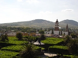
Salvatierra is a Mexican
city (and municipality
) located in the valley of Huatzindeo in the lowlands
of the state of Guanajuato
. With an area of 507.70 square kilometres, Salvatierra accounts for 1.66% the total area of the state. It is bordered to the north by Tarimoro
and Cortazar
, to the south by Acámbaro
and the state of Michoacán
, to the west by Yuriria
and Santiago Maravatío
, and to the northeast by Jaral del Progreso
. The municipality had a total of 94,558 inhabitants of which 34,066 lived in the city of Salvatierra, according to the 2005 census..
In pre-Columbian
times the area was known as Guatzindeo or "Place of beautiful vegetation" by the mostly P'urhépecha
inhabitants.
culture, who by the 12th century were found in many communities across the valley. The Chichimeca were eventually conquered by the P'urhépecha
, along with most of the lower region of the present-day state of Guanajuato.
The first Europeans
to arrive to the valley of Huatzindeo were Franciscan friars
who came to the region with the intent of converting the native populations to Christianity
. The Franciscan friars built and ran the first Spanish "hospitalillo," hospital, in the indigenous village of Huatziendeo (located to the left of the Lerma river) between 1535 and 1550.
The Franciscan friars were soon joined by cacique
s and other Spanish pioneers who settled in the valley of Huatzindeo and built haciendas. Much of the hard labor at the haciendas was provided via encomienda
s by the indigenous population.
By 1600 typhoid fever, smallpox and other diseases had almost wiped out the native population who lacked the needed antibodies since these diseases were alien to the native population at the time, and the village of Huatzindeo ceased to exist. Many of the Spaniards already in the area relocated to Yuriria
pundaro, while others remained and founded San Andrés Chochones. San Andrés Chochones was built on the right side of the Lerman river - directly across from where the village of Huatzindeo had once stood.
San Andrés de Salvatierra was founded under the order of Spanish viceroy Don Garcia Sarmiento de Sotomayor, 2nd Count of Salvatierra and Marquis of Sobroso
, on February 9, 1644. In 1646 the town was granted the title of city, becoming the first city in the state of Guanajuato.
Due to its rich soil and strategic location (midway between the three most populated areas, namely Mexico City, Guadalajara, and Monterrey) for most of the next three centuries the city was one of the most prosperous in the state of Guanajuato. However, unlike León
, Irapuato
, and Celaya, Salvatierra never developed into a strong industrial town and has seen its working population shrink with many choosing to relocate to nearby cities and others leaving the country entirely to seek jobs in the United States
. Some microregions in the minicipality have immigration levels of well over 50%, while the rate stands at 30% in the city.
Cities and areas in the United States with sizable populations from Salvatierra include Los Angeles, CA, Dallas, TX, Detroit, MI, the Atlanta metro area, Moline, and especially Chicago Metro area, in Illinois
.
Mexico
The United Mexican States , commonly known as Mexico , is a federal constitutional republic in North America. It is bordered on the north by the United States; on the south and west by the Pacific Ocean; on the southeast by Guatemala, Belize, and the Caribbean Sea; and on the east by the Gulf of...
city (and municipality
Municipalities of Guanajuato
The Mexican state of Guanajuato is divided into 46 municipalities :- References :*Instituto Nacional de Estadística y Geografía : «Principales resultados por localidad 2005 » ....
) located in the valley of Huatzindeo in the lowlands
Bajío
The Bajío is a region of Central Mexico that includes the plains south of the Sierra de Guanajuato, in the state of Guanajuato, as well as parts of the states of Querétaro and Michoacán .In general parlance, it is usually associated with the States of Guanajuato and Querétaro, although it only...
of the state of Guanajuato
Guanajuato
Guanajuato officially Estado Libre y Soberano de Guanajuato is one of the 31 states which, with the Federal District, comprise the 32 Federal Entities of Mexico. It is divided in 46 municipalities and its capital city is Guanajuato....
. With an area of 507.70 square kilometres, Salvatierra accounts for 1.66% the total area of the state. It is bordered to the north by Tarimoro
Tarimoro
This article is about the Municipality. For the City with the same name, see Tarimoro, GuanajuatoTarimoro is one of the 46 municipalities of the Mexican state of Guanajuato. The municipal seat is the city of Tarimoro....
and Cortazar
Cortazar, Guanajuato
Cortazar is a city and its surrounding municipality located in the southeastern quadrant of the state of Guanajuato in Mexico. It is bordered to the north by Villagrán, to the north and east by Celaya, to the southeast by Tarimoro, to the south by Salvatierra, and to the west by Jaral del Progreso...
, to the south by Acámbaro
Acámbaro
Acámbaro is a city and municipality in the southeastern corner of the Mexican state of Guanajuato, on the banks of the Lerma River, and the oldest of the 46 municipalities of Guanajuato. Acámbaro is noted as a major railway junction, a local transport hub, and the origin of the nationally famous...
and the state of Michoacán
Michoacán
Michoacán officially Estado Libre y Soberano de Michoacán de Ocampo is one of the 31 states which, with the Federal District, comprise the 32 Federal Entities of Mexico. It is divided in 113 municipalities and its capital city is Morelia...
, to the west by Yuriria
Yuriria
Yuririapundaro, Guanajuato, Mexico, also known as Yuriria, is one of 46 municipalities in the Mexican state of Guanajuato. Its location and historical importance are key factors to the outstanding and significal importance of the municipality....
and Santiago Maravatío
Santiago Maravatío
Santiago Maravatío is a Mexican city located in the Bajío of the state of Guanajuato. With an area of 91.760 square kilometres, Santiago Maravatío accounts for less than 1% of the surface of the state...
, and to the northeast by Jaral del Progreso
Jaral del Progreso
Jaral del Progreso is a Mexican city and municipality located in the Bajío of the state of Guanajuato. With an area of 174.37 square kilometres, Jaral del Progreso accounts for 0.57% of the surface of the state...
. The municipality had a total of 94,558 inhabitants of which 34,066 lived in the city of Salvatierra, according to the 2005 census..
In pre-Columbian
Pre-Columbian
The pre-Columbian era incorporates all period subdivisions in the history and prehistory of the Americas before the appearance of significant European influences on the American continents, spanning the time of the original settlement in the Upper Paleolithic period to European colonization during...
times the area was known as Guatzindeo or "Place of beautiful vegetation" by the mostly P'urhépecha
P'urhépecha
The P'urhépecha, normally spelled Purépecha in Spanish and in English and traditionally referred to as Tarascans, are an indigenous people centered in the northwestern region of the Mexican state of Michoacán, principally in the area of the cities of Uruapan and Pátzcuaro...
inhabitants.
San Andrés de Salvatierra
The first inhabitants of valley of Huatzindeo belonged to the ChichimecaChichimeca
Chichimeca was the name that the Nahua peoples of Mexico generically applied to a wide range of semi-nomadic peoples who inhabited the north of modern-day Mexico and southwestern United States, and carried the same sense as the European term "barbarian"...
culture, who by the 12th century were found in many communities across the valley. The Chichimeca were eventually conquered by the P'urhépecha
P'urhépecha
The P'urhépecha, normally spelled Purépecha in Spanish and in English and traditionally referred to as Tarascans, are an indigenous people centered in the northwestern region of the Mexican state of Michoacán, principally in the area of the cities of Uruapan and Pátzcuaro...
, along with most of the lower region of the present-day state of Guanajuato.
The first Europeans
Europe
Europe is, by convention, one of the world's seven continents. Comprising the westernmost peninsula of Eurasia, Europe is generally 'divided' from Asia to its east by the watershed divides of the Ural and Caucasus Mountains, the Ural River, the Caspian and Black Seas, and the waterways connecting...
to arrive to the valley of Huatzindeo were Franciscan friars
Franciscan
Most Franciscans are members of Roman Catholic religious orders founded by Saint Francis of Assisi. Besides Roman Catholic communities, there are also Old Catholic, Anglican, Lutheran, ecumenical and Non-denominational Franciscan communities....
who came to the region with the intent of converting the native populations to Christianity
Christianity
Christianity is a monotheistic religion based on the life and teachings of Jesus as presented in canonical gospels and other New Testament writings...
. The Franciscan friars built and ran the first Spanish "hospitalillo," hospital, in the indigenous village of Huatziendeo (located to the left of the Lerma river) between 1535 and 1550.
The Franciscan friars were soon joined by cacique
Cacique
Cacique is a title derived from the Taíno word for the pre-Columbian chiefs or leaders of tribes in the Bahamas, Greater Antilles, and the northern Lesser Antilles...
s and other Spanish pioneers who settled in the valley of Huatzindeo and built haciendas. Much of the hard labor at the haciendas was provided via encomienda
Encomienda
The encomienda was a system that was employed mainly by the Spanish crown during the colonization of the Americas to regulate Native American labor....
s by the indigenous population.
By 1600 typhoid fever, smallpox and other diseases had almost wiped out the native population who lacked the needed antibodies since these diseases were alien to the native population at the time, and the village of Huatzindeo ceased to exist. Many of the Spaniards already in the area relocated to Yuriria
Yuriria
Yuririapundaro, Guanajuato, Mexico, also known as Yuriria, is one of 46 municipalities in the Mexican state of Guanajuato. Its location and historical importance are key factors to the outstanding and significal importance of the municipality....
pundaro, while others remained and founded San Andrés Chochones. San Andrés Chochones was built on the right side of the Lerman river - directly across from where the village of Huatzindeo had once stood.
San Andrés de Salvatierra was founded under the order of Spanish viceroy Don Garcia Sarmiento de Sotomayor, 2nd Count of Salvatierra and Marquis of Sobroso
García Sarmiento de Sotomayor, 2nd conde de Salvatierra
García Sarmiento de Sotomayor, 2nd Count of Salvatierra and Marquis of Sobroso was a Spanish viceroy of New Spain and of Peru .-Early life:...
, on February 9, 1644. In 1646 the town was granted the title of city, becoming the first city in the state of Guanajuato.
Due to its rich soil and strategic location (midway between the three most populated areas, namely Mexico City, Guadalajara, and Monterrey) for most of the next three centuries the city was one of the most prosperous in the state of Guanajuato. However, unlike León
León, Guanajuato
The city of León, formally León de los Aldama is the sixth most populous city in Mexico and the first in the state of Guanajuato. It is also the seat of the municipality of León...
, Irapuato
Irapuato, Guanajuato
Irapuato is a Mexican city located at the foot of the Arandas mountain , in the south central region of the state of Guanajuato. It lies between the Silao River and the Guanajuato River, a tributary of the Lerma River, at 1,724 m above sea level. It is located at...
, and Celaya, Salvatierra never developed into a strong industrial town and has seen its working population shrink with many choosing to relocate to nearby cities and others leaving the country entirely to seek jobs in the United States
United States
The United States of America is a federal constitutional republic comprising fifty states and a federal district...
. Some microregions in the minicipality have immigration levels of well over 50%, while the rate stands at 30% in the city.
Cities and areas in the United States with sizable populations from Salvatierra include Los Angeles, CA, Dallas, TX, Detroit, MI, the Atlanta metro area, Moline, and especially Chicago Metro area, in Illinois
Illinois
Illinois is the fifth-most populous state of the United States of America, and is often noted for being a microcosm of the entire country. With Chicago in the northeast, small industrial cities and great agricultural productivity in central and northern Illinois, and natural resources like coal,...
.
Microregions
| Name | Population |
|---|---|
| Urireo | 7,649 |
| San Nicolás de los Agustinos | 6,878 |
| San Pedro de los Naranjos | 4,365 |
| El Sabino | 3,904 |
| Maravatío del Encinal | 3,262 |
| Cupareo Cupareo Cupareo is a small rural town in the Mexican state of Guanajuato, and belongs to the municipality of Salvatierra. Cupareo comes from the Tarascan language and means "Crossroads."... |
1,982 |
| Santo Tomás Huatzindeo | 1,950 |
| Ojo de Agua de Ballesteros | 1,633 |
| San Miguel Eménguaro | 1,526 |
| La Luz | 1,283 |
| La Quemada | 1,123 |
| La Estancia de San José del Carmen | 1,252 |
External links
- Cupareo, Mpio. de Salvatierra
- Municipality Web site (in Spanish)