
.gif)
Route 47 (New Jersey)
Encyclopedia
Route 47 is a state highway
in the southern part of New Jersey
, United States. It runs 75.2 mi (121.02 km) from Atlantic Avenue in Wildwood
, Cape May County
north to U.S. Route 130
in Brooklawn
, Camden County
. It is also referred to as Delsea Drive, as it connects the Delaware River
near Brooklawn to the Atlantic Ocean
(the sea) in Wildwood. This name was assigned by the New Jersey Legislature
in 1933. The route runs through rural areas of Cape May and southern Cumberland
counties as a two-lane road. Traffic jams along this portion of Route 47 are commonplace in the summer vacation season and can stretch for miles due to the missing southern section of Route 55, where all Jersey Shore
-bound traffic enters the small two-lane road. North of here, the route runs through the cities of Millville
and Vineland
before entering Gloucester County
, where it passes through more rural areas as well as Clayton
and Glassboro
. Past Glassboro, it heads through suburban areas in Washington
and Deptford
townships before running through Westville
and Brooklawn. Route 47 is the longest state route in New Jersey.
What is now Route 47 was originally designated as part of pre-1927 Route 15 between Rio Grande
in 1917 and as a branch of pre-1927 Route 20 between Millville and Westville in 1923. In 1927, Route 47 was designated to run from Tuckahoe
to Brooklawn, following current Route 49 south of Millville. Meanwhile, current Route 47 was a part of Route 49 between South Dennis
and Millville and Route S49 between Rio Grande and South Dennis. The latter was extended to Wildwood in 1938. Route 47 and Route 49 were shifted onto their current alignments south of Millville in 1953. Since then, Route 47 has seen a few improvements and modifications including realignment in Millville and the reconstruction of the intersection with Route 83 in Dennis Township
.
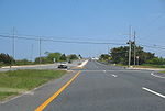 Route 47 begins at a traffic light with Atlantic Avenue in the beach resort of Wildwood
, Cape May County
, heading to the northwest on Rio Grande Avenue, a four-lane divided highway
that is county maintained and signed as County Route 661. From this intersection, Rio Grande Avenue continues southeast a block to an intersection with Ocean Avenue near the Wildwood boardwalk. The road passes through resort residential and commercial areas before crossing County Route 621 (Ocean Drive), where it becomes a four-lane undivided road. Upon crossing Park Boulevard, the route passes businesses and intersects Susquehanna Avenue. Here, Route 47 becomes signed and maintained by the New Jersey Department of Transportation
, turning into a divided highway again a short distance later at the intersection with County Route 624 (West Rio Grande Boulevard). At this intersection, the route enters Lower Township
and crosses over the Grassy Sound via the George Reading Wildwood Bridge. The road turns more to the west-northwest and runs through wetlands with some homes to the south of the road. Route 47 enters Middle Township
and continues past more marshland as well as some marinas adjacent to the Richardson Sound on the south side of the road. The route turns northwest again and comes to a partial cloverleaf interchange with the Garden State Parkway
. Past this interchange, Route 47 heads into a commercial district in the Rio Grande
section of Middle Township. At the intersection with Fifth Street, the route becomes a three-lane undivided road with a center left-turn lane and continues to an intersection with U.S. Route 9 (Shore Road).
 Past the U.S. Route 9 intersection, Route 47 becomes Delsea Drive and continues past more businesses, crossing the Cape May Seashore Lines
railroad before intersecting County Route 626. Here, the route becomes a two-lane road and heads into more residential areas with some commercial establishments. At the intersection with County Route 654, Route 47 turns north and leaves the Rio Grande area, heading into woods with some farm fields. It passes homes again and intersects County Route 603 in Green Creek
. From here, the road continues past homes with some areas of forests and farms. Route 47 comes to an intersection with County Route 618 which, along with Route 147
, provides an alternate route to The Wildwoods
. Past this intersection, the road passes more rural dwellings and enters the community of Dias Creek, where it intersects County Route 612. The route crosses over Bidwell Creek near wetlands and heads into forests. It reaches the residential community of Goshen
, where there is an intersection with County Route 615. Past Goshen, Route 47 turns northeast and heads through rural woods and farms with some homes and wetlands.
Upon crossing Sluice Creek, the route enters Dennis Township
and heads into residential areas in the community of South Dennis
. Here, the road intersects County Route 657 and turns to the north. Route 47 briefly widens into a two-lane divided highway as it intersects the western terminus of Route 83. Past this intersection, the road heads through marshland and crosses over the Dennis Creek
. It continues into Dennisville
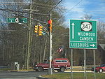
, where the route intersects County Route 610 before turning west near Johnson Pond and intersecting County Route 611 (Tyler Road). Route 47 passes more homes before coming to the southern terminus of County Route 557
. Past the County Route 557 intersection, the road runs through woodland before coming to the southern terminus of Route 347. Here, Route 47 turns to the west and passes a mix of residences, woods, and fields. It turns northwest and crosses East Creek before coming to an intersection with County Route 550 Spur. Past this intersection, the road intersects Old State Highway, a connector road to County Route 550 Spur, before turning west into wooded areas.
 Upon crossing West Creek, Route 47 enters Maurice River Township
, Cumberland County
and continues west through more forests. It enters a mix of residences and woodland as it makes a turn to the north past the intersection with County Route 651. The route runs through more woods, with a clearing for Bayside State Prison
to the east of the road. The road comes to an intersection with County Route 550
and County Route 710 to the east of Leesburg
and continues north. Route 47 reaches an intersection with County Route 670 in a commercial area prior to Route 347 merging back into the route. Here, Route 47 splits into a brief one-way pair
with the northbound direction heading east on County Route 670 and north on Route 347, and the southbound direction remaining on Delsea Drive. From here, Route 47 continues north on Delsea Drive through forested areas with some homes before crossing over the Muskee Creek. It continues into the community of Port Elizabeth
, where it meets the western terminus of County Route 548
. Just past this intersection, the route crosses the Manumuskin River
and continues north through woodland with some development. The route intersects the southern terminus of Route 55, where that route continues north along the road and Route 47 turns off at a jughandle
. South of the Route 55 intersection, Route 47 is part of a major road linking the Philadelphia area with the Jersey Shore
resorts of Cape May County. During the summer months, it sees regular traffic jams from traffic coming off Route 55. A proposal to extend Route 55 south to Cape May County, on hold for decades due to environmental concerns, would relieve traffic along Route 47.
From here, Route 47 continues through a mix of trees and residences, intersecting Schooner Landing Road, which provides access to and from northbound Route 55. Just past this intersection, the route crosses the Manantico Creek
into Millville
, where it becomes South Second Street, and continues past more woodland containing residences. As the route continues north, residential development increases along with commercial and industrial establishments. Route 47 reaches the commercial downtown of Millville, where it crosses Route 49/County Route 555
and becomes North Second Street. County Route 555 parallels Route 47 a block to the east as the road crosses a Conrail Shared Assets Operations
railroad line and intersects County Route 552 Spur. Past this intersection, County Route 555 heads farther to the east and Route 47 crosses the Conrail Shared Assets Operations line a second time, passing a mix of residences, businesses, and industrial buildings. The road becomes three lanes with a center-left turn lane as it heads through commercial areas in the northern part of Millville. Upon intersecting High Street, the route widens to five lanes before entering Vineland
, where the name becomes Delsea Drive again and it intersects Route 55 at a partial cloverleaf interchange.
Past this interchange, Route 47 passes the Cumberland Mall
on the east side of the road as a six-lane divided highway. Past the mall, the route becomes a five-lane road with a center left-turn lane again and passes more commercial establishments in the southern part of Vineland, before heading into wooded residential areas with some farmland. It crosses County Route 552
and becomes a two-lane road, running through business areas with some homes. As Route 47 continues north through the city, it comes to an intersection with Chestnut Avenue, where it gains a center left-turn lane. From here, it passes more commercial buildings before crossing Landis Avenue, which heads to the west as Route 56. Past this intersection, the road crosses a Winchester & Western Railroad line before intersecting County Route 540
. Route 47 continues north through a mix of dwellings and businesses in the northern part of Vineland, narrowing back into a two-lane road at the crossing of County Route 681. The road heads through predominantly residential areas as it comes to an intersection with County Route 674. Past this intersection, the route passes near Kroelinger Airport
and continues through mostly rural inhabited areas with some businesses. It crosses County Route 690 (Weymouth Road) before passing though wooded sectors with some homes and farms.
, Gloucester County
, where it passes more farms, woods, and homes before coming to an intersection with U.S. Route 40
in the community of Malaga
. Here, U.S. Route 40 and Route 47 form a concurrency
and head northeast through populated areas as a three-lane road with a center left-turn lane, crossing over a Conrail Shared Assets Operations railroad line. Immediately after this crossing, U.S. Route 40 splits from Route 47 by heading southeast on Harding Highway while Route 47 turns northwest to continue along Delsea Drive, a two-lane road. Route 47 leaves Malaga and passes through a mix of dwellings and businesses with some areas of farms and woods, running a short distance to the east of the railroad line. The road heads into more forested areas before it comes to an intersection with County Route 612 in the residential and business community of Iona. Route 47 continues past homes and commercial establishments as it comes to a crossroads with County Route 538
, where it turns to the north. The route passes more development with some farmland before it enters Clayton
.
Here, the road heads through residential areas with some commercial establishments, crossing County Route 610 in the center of town. As the road continues north, it heads through a mix of homes and farmland with a few commercial areas. Route 47 enters inhabited areas again as it crosses into Glassboro
. The road continues north and enters business areas before heading into neighborhoods and coming to an intersection with High Street, which runs east as U.S. Route 322
/County Route 536
and west as County Route 641. Here, U.S. Route 322 and County Route 536 join Route 47 for a concurrency. The three routes head through commercial areas before U.S. Route 322 and County Route 536 turn to the west on West Avenue. Past this intersection, Route 47 continues north as a three-lane road with a center left-turn lane, passing more buildings. The route intersects County Route 553
and forms a concurrency with that route which lasts until County Route 553 turns north onto Woodbury Avenue. Along this concurrency, the road widens to five lanes as it passes a couple shopping centers. Past the concurrency, Route 47 runs north through suburban localities as a two-lane road, entering Washington Township
at the crossing of Kressey Lake. In Washington Township, the road passes more populated areas as well as businesses. Route 47 runs to the east of Bethel Mill County Park before entering more residential areas, crossing County Route 635. The road passes through a mix of homes and commercial establishments with some farmland and wooded areas as it continues through more of Washington Township.
At the border with Deptford Township
, Route 47 reaches an intersection known as Five Points. Here, the road meets Route 41, County Route 603, and County Route 630. Route 47 turns northwest as this intersection and runs through wooded areas with some dwellings, with Route 55 intersecting the route at a cloverleaf interchange
a short distance later. Past this interchange, the road continues through wooded inhabited areas, eventually turning due north. It comes to an intersection with the western terminus of County Route 534
as the route heads through more suburban homes along with businesses. Past this intersection, Route 47 passes businesses before crossing over the New Jersey Turnpike
without an interchange. From here, it heads through more inhabited areas before entering Westville
. Upon entering Westville, the route has a partial cloverleaf interchange with Interstate 295
. Past this interchange, the road runs through neighborhoods, intersecting County Route 621 (Almonesson Road) and County Route 551
. The latter forms a concurrency with Route 47 and these two routes run northeast through commercial areas as a four-lane undivided road, crossing the Big Timber Creek
into Brooklawn
, Camden County
. Here, it comes to a traffic circle
with U.S. Route 130
and County Route 753, where Route 47 ends and County Route 551 continues on to Camden
, forming a brief concurrency with U.S. Route 130.
, Route 47 was legislated to run from Route 50 in Tuckahoe
to Brooklawn, following present-day Route 49 between Tuckahoe and Millville and its current alignment north of Millville. Meanwhile, the present-day alignment of Route 47 between the current Route 83 intersection in South Dennis and Millville was designated a part of Route 49 while the current alignment between South Dennis and U.S. Route 9/Route 4 in Rio Grande became Route S49, a spur of Route 49. In 1933, the New Jersey Legislature
named Route 47 Delsea Drive after a reporter for the Woodbury Times joked how the road connected the DELaware River to the Atlantic SEA. Route S49 was extended from Rio Grande to Park Boulevard in Wildwood in 1938. In the 1953 New Jersey state highway renumbering
, Route 47 and Route 49 switched alignments south and east of Millville and Route 47 replaced Route S49 south to Wildwood.
By the 1980s, Route 47 was moved from High Street to North Second Street through the northern part of Millville. An alternate route of Route 47 was eventually created to the east along county routes in Cape May and Cumberland counties; this eventually became Route 347 by the 1990s. In the 2000s, Rio Grande Avenue in Wildwood received improvements to make it reminisce the doo wop atmosphere the beach resort is known for. The Route 47 bridge over Dennis Creek in Dennis Township and the Route 83 intersection received improvements that were completed in July 2007. The Route 47 bridge over the creek was structurally deficient and in need of replacing. The job was completed with wider shoulders and a wider sidewalk on the new bridge. The intersection between Route 47 and Route 83 was also realigned and had signals installed.
State highway
State highway, state road or state route can refer to one of three related concepts, two of them related to a state or provincial government in a country that is divided into states or provinces :#A...
in the southern part of New Jersey
New Jersey
New Jersey is a state in the Northeastern and Middle Atlantic regions of the United States. , its population was 8,791,894. It is bordered on the north and east by the state of New York, on the southeast and south by the Atlantic Ocean, on the west by Pennsylvania and on the southwest by Delaware...
, United States. It runs 75.2 mi (121.02 km) from Atlantic Avenue in Wildwood
Wildwood, New Jersey
Wildwood is a city in Cape May County, New Jersey, United States. It is part of the Ocean City Metropolitan Statistical Area and is a popular summer resort destination. As of the 2010 United States Census, the city's year-round population was 5,325...
, Cape May County
Cape May County, New Jersey
-Climate:Being the southernmost point in New Jersey, Cape May has fairly mild wintertime temperatures. Contrary to that, the summertime has lower temperatures than most places in the state, making the county a popular place to escape the heat. It is in zone 7a/7b, which is the same as parts of...
north to U.S. Route 130
U.S. Route 130
U.S. Route 130 is a north–south U.S. Highway completely within the state of New Jersey. It runs from Interstate 295 and US 40 at Deepwater in Pennsville Township, Salem County, where the road continues east as Route 49, north to US 1 in North Brunswick Township, Middlesex County, where...
in Brooklawn
Brooklawn, New Jersey
Brooklawn is a Borough in Camden County, New Jersey, United States. As of the 2010 United States Census, the borough population was 1,955.Brooklawn was incorporated as a borough on March 11, 1924, from portions of the now-defunct Centre Township, based on the results of a referendum held on April...
, Camden County
Camden County, New Jersey
-Demographics:As of the 2010 Census the population of Camden County was 60.28% Non-Hispanic white, 18.45% Non-Hispanic black, 1.12% Hispanic blacks, 0.17% Non-Hispanic Native American, 0.15% Hispanic Native Americans, 5.07% Non-Hispanic Asian, and 0.14% non-Hispanics reporting some other race...
. It is also referred to as Delsea Drive, as it connects the Delaware River
Delaware River
The Delaware River is a major river on the Atlantic coast of the United States.A Dutch expedition led by Henry Hudson in 1609 first mapped the river. The river was christened the South River in the New Netherland colony that followed, in contrast to the North River, as the Hudson River was then...
near Brooklawn to the Atlantic Ocean
Atlantic Ocean
The Atlantic Ocean is the second-largest of the world's oceanic divisions. With a total area of about , it covers approximately 20% of the Earth's surface and about 26% of its water surface area...
(the sea) in Wildwood. This name was assigned by the New Jersey Legislature
New Jersey Legislature
The New Jersey Legislature is the legislative branch of the government of the U.S. state of New Jersey. In its current form, as defined by the New Jersey Constitution of 1947, the Legislature consists of two houses: the General Assembly and the Senate...
in 1933. The route runs through rural areas of Cape May and southern Cumberland
Cumberland County, New Jersey
Cumberland County is a county located in the U.S. state of New Jersey. As of the 2010 Census, the population is 156,898. Its county seat is Bridgeton. Cumberland County is named for Prince William, Duke of Cumberland....
counties as a two-lane road. Traffic jams along this portion of Route 47 are commonplace in the summer vacation season and can stretch for miles due to the missing southern section of Route 55, where all Jersey Shore
Jersey Shore
The Jersey Shore is a term used to refer to both the Atlantic coast of the U.S. state of New Jersey and the adjacent resort and residential communities. . The New Jersey State Department of Tourism considers the Shore Region, Greater Atlantic City, and the Southern Shore to be distinct, each having...
-bound traffic enters the small two-lane road. North of here, the route runs through the cities of Millville
Millville, New Jersey
Millville is a city in Cumberland County, New Jersey, United States. As of the 2000 United States Census, the city population was 26,847. Millville, Bridgeton and Vineland are the three principal New Jersey cities of the Vineland-Millville-Bridgeton Primary Metropolitan Statistical Area which...
and Vineland
Vineland, New Jersey
Vineland is a city in Cumberland County, New Jersey, United States. As of the 2010 United States Census, the city had a total population of 60,724...
before entering Gloucester County
Gloucester County, New Jersey
Gloucester County is a county located in the U.S. state of New Jersey. As of the 2010 Census, the population was 288,288. Its county seat is Woodbury....
, where it passes through more rural areas as well as Clayton
Clayton, New Jersey
Clayton is a Borough in Gloucester County, New Jersey, United States. As of the 2010 United States Census, the borough population was 8,179.Jacob Fisler, who purchased much of the area that is now Clayton, established a community called Fislertown in 1850 that grew substantially after he opened a...
and Glassboro
Glassboro, New Jersey
Glassboro is a borough in Gloucester County, New Jersey, United States. As of the United States 2000 Census, the borough population was 19,068....
. Past Glassboro, it heads through suburban areas in Washington
Washington Township, Gloucester County, New Jersey
Washington Township is a township in Gloucester County, New Jersey, United States. In the 2010 United States Census, Washington Township's population was 48,559, having grown from 47,114 in the 2000 Census....
and Deptford
Deptford Township, New Jersey
Deptford Township is a township in Gloucester County, New Jersey, in the United States. As of the 2010 United States Census, the township's population was 30,561....
townships before running through Westville
Westville, New Jersey
Westville is a Borough in Gloucester County, New Jersey, United States. As of the 2000 United States Census, the borough population was 4,501. The Borough of Westville is known as "The Gateway to South Jersey."...
and Brooklawn. Route 47 is the longest state route in New Jersey.
What is now Route 47 was originally designated as part of pre-1927 Route 15 between Rio Grande
Rio Grande, New Jersey
Rio Grande is a census-designated place and unincorporated area located within Middle Township, in Cape May County, New Jersey. It is part of the Ocean City Metropolitan Statistical Area...
in 1917 and as a branch of pre-1927 Route 20 between Millville and Westville in 1923. In 1927, Route 47 was designated to run from Tuckahoe
Tuckahoe, New Jersey
Tuckahoe is an unincorporated community in Upper Township, Cape May County, New Jersey, United States.-Bridge construction:A bridge, constructed in 1920 and renovated in 1962, connects Tuckahoe to Corbin City, its neighbor to the north...
to Brooklawn, following current Route 49 south of Millville. Meanwhile, current Route 47 was a part of Route 49 between South Dennis
South Dennis, New Jersey
South Dennis is an unincorporated area in Dennis Township, in Cape May County, New Jersey, United States. It is part of the Ocean City Metropolitan Statistical Area. Its postal ZIP Code is 08245.-Demographics:...
and Millville and Route S49 between Rio Grande and South Dennis. The latter was extended to Wildwood in 1938. Route 47 and Route 49 were shifted onto their current alignments south of Millville in 1953. Since then, Route 47 has seen a few improvements and modifications including realignment in Millville and the reconstruction of the intersection with Route 83 in Dennis Township
Dennis Township, New Jersey
Dennis Township is a township in Cape May County, New Jersey, United States. It is part of the Ocean City Metropolitan Statistical Area. The township population was 6,492 as of the United States 2000 Census...
.
Cape May County
Wildwood, New Jersey
Wildwood is a city in Cape May County, New Jersey, United States. It is part of the Ocean City Metropolitan Statistical Area and is a popular summer resort destination. As of the 2010 United States Census, the city's year-round population was 5,325...
, Cape May County
Cape May County, New Jersey
-Climate:Being the southernmost point in New Jersey, Cape May has fairly mild wintertime temperatures. Contrary to that, the summertime has lower temperatures than most places in the state, making the county a popular place to escape the heat. It is in zone 7a/7b, which is the same as parts of...
, heading to the northwest on Rio Grande Avenue, a four-lane divided highway
Divided Highway
Divided Highway is a compilation album by American rock band The Doobie Brothers, released in 2003. . All tracks are taken from the albums Cycles and Brotherhood .-Track listing:...
that is county maintained and signed as County Route 661. From this intersection, Rio Grande Avenue continues southeast a block to an intersection with Ocean Avenue near the Wildwood boardwalk. The road passes through resort residential and commercial areas before crossing County Route 621 (Ocean Drive), where it becomes a four-lane undivided road. Upon crossing Park Boulevard, the route passes businesses and intersects Susquehanna Avenue. Here, Route 47 becomes signed and maintained by the New Jersey Department of Transportation
New Jersey Department of Transportation
The New Jersey Department of Transportation is the agency responsible for transportation issues and policy in New Jersey. It is headed by the Commissioner of Transportation...
, turning into a divided highway again a short distance later at the intersection with County Route 624 (West Rio Grande Boulevard). At this intersection, the route enters Lower Township
Lower Township, New Jersey
Lower Township is a township in Cape May County, New Jersey, United States. It is part of the Ocean City Metropolitan Statistical Area. As of the United States 2000 Census, the township population was 22,945....
and crosses over the Grassy Sound via the George Reading Wildwood Bridge. The road turns more to the west-northwest and runs through wetlands with some homes to the south of the road. Route 47 enters Middle Township
Middle Township, New Jersey
Middle Township is a township in Cape May County, New Jersey, United States. It is part of the Ocean City Metropolitan Statistical Area. As of the United States 2000 Census, the township population was 16,405....
and continues past more marshland as well as some marinas adjacent to the Richardson Sound on the south side of the road. The route turns northwest again and comes to a partial cloverleaf interchange with the Garden State Parkway
Garden State Parkway
The Garden State Parkway is a 172.4-mile limited-access toll parkway that stretches the length of New Jersey from the New York line at Montvale, New Jersey, to Cape May at New Jersey's southernmost tip. Its name refers to New Jersey's nickname, the "Garden State." Most New Jersey residents refer...
. Past this interchange, Route 47 heads into a commercial district in the Rio Grande
Rio Grande, New Jersey
Rio Grande is a census-designated place and unincorporated area located within Middle Township, in Cape May County, New Jersey. It is part of the Ocean City Metropolitan Statistical Area...
section of Middle Township. At the intersection with Fifth Street, the route becomes a three-lane undivided road with a center left-turn lane and continues to an intersection with U.S. Route 9 (Shore Road).
Cape May Seashore Lines
Cape May Seashore Lines is a short line railroad in southern New Jersey. It offers two excursion services; a 30-mile round trip between Richland and Tuckahoe, and a 14-mile round trip between Rio Grande, Cold Spring Village, and Cape May City. The track is owned by New Jersey Transit and leased to...
railroad before intersecting County Route 626. Here, the route becomes a two-lane road and heads into more residential areas with some commercial establishments. At the intersection with County Route 654, Route 47 turns north and leaves the Rio Grande area, heading into woods with some farm fields. It passes homes again and intersects County Route 603 in Green Creek
Green Creek, New Jersey
Green Creek is an unincorporated community located within Middle Township, Cape May County, New Jersey, United States. It is located on New Jersey State Route 47. It is a very low lying area with a highest elevation of just above 20 feet. The community is located about 3 miles west of Rio Grande...
. From here, the road continues past homes with some areas of forests and farms. Route 47 comes to an intersection with County Route 618 which, along with Route 147
New Jersey Route 147
Route 147 is a state highway located in Cape May County in New Jersey, United States. It is a short connector between U.S. Route 9 in Middle Township and North Wildwood at New York Avenue. West of U.S. Route 9, the road continues to Route 47 as County Route 618 ; this route along with Route 147...
, provides an alternate route to The Wildwoods
The Wildwoods
The Wildwoods are a group of five municipalities in Cape May County, New Jersey, all of which are situated on the Island of Five Mile Beach, a barrier island facing the Atlantic Ocean...
. Past this intersection, the road passes more rural dwellings and enters the community of Dias Creek, where it intersects County Route 612. The route crosses over Bidwell Creek near wetlands and heads into forests. It reaches the residential community of Goshen
Goshen, New Jersey
Goshen is an unincorporated community in Cape May County, New Jersey, United States . Route 47, also known as Delsea Drive, runs directly through the center of the community....
, where there is an intersection with County Route 615. Past Goshen, Route 47 turns northeast and heads through rural woods and farms with some homes and wetlands.
Upon crossing Sluice Creek, the route enters Dennis Township
Dennis Township, New Jersey
Dennis Township is a township in Cape May County, New Jersey, United States. It is part of the Ocean City Metropolitan Statistical Area. The township population was 6,492 as of the United States 2000 Census...
and heads into residential areas in the community of South Dennis
South Dennis, New Jersey
South Dennis is an unincorporated area in Dennis Township, in Cape May County, New Jersey, United States. It is part of the Ocean City Metropolitan Statistical Area. Its postal ZIP Code is 08245.-Demographics:...
. Here, the road intersects County Route 657 and turns to the north. Route 47 briefly widens into a two-lane divided highway as it intersects the western terminus of Route 83. Past this intersection, the road heads through marshland and crosses over the Dennis Creek
Dennis Creek
Dennis Creek is an tributary of Delaware Bay in Cape May County, New Jersey in the United States.It originates in the Great Cedar Swamp to the southeast of Dennisville, New Jersey. Passing between Dennisville and South Dennis, it descends into the tidal marshes and joins Sluice Creek and...
. It continues into Dennisville
Dennisville, New Jersey
Dennisville is an unincorporated area in Dennis Township, in Cape May County, New Jersey, United States. It is part of the Ocean City Metropolitan Statistical Area. Its postal ZIP Code is 08214....
, where the route intersects County Route 610 before turning west near Johnson Pond and intersecting County Route 611 (Tyler Road). Route 47 passes more homes before coming to the southern terminus of County Route 557
County Route 557 (New Jersey)
County Route 557, abbreviated CR 557, is a county highway in the U.S. state of New Jersey. The highway extends from Delsea Drive in Dennis Township to Main Street in Franklin Township.-Cape May County:...
. Past the County Route 557 intersection, the road runs through woodland before coming to the southern terminus of Route 347. Here, Route 47 turns to the west and passes a mix of residences, woods, and fields. It turns northwest and crosses East Creek before coming to an intersection with County Route 550 Spur. Past this intersection, the road intersects Old State Highway, a connector road to County Route 550 Spur, before turning west into wooded areas.
Cumberland County
Maurice River Township, New Jersey
Maurice River Township is a township in Cumberland County, New Jersey, United States. It is part of the Vineland-Millville- Bridgeton Primary Metropolitan Statistical Area for statistical purposes...
, Cumberland County
Cumberland County, New Jersey
Cumberland County is a county located in the U.S. state of New Jersey. As of the 2010 Census, the population is 156,898. Its county seat is Bridgeton. Cumberland County is named for Prince William, Duke of Cumberland....
and continues west through more forests. It enters a mix of residences and woodland as it makes a turn to the north past the intersection with County Route 651. The route runs through more woods, with a clearing for Bayside State Prison
Bayside State Prison
Bayside State Prison is a state prison for men located in Leesburg, Maurice River Township, New Jersey. It is of the New Jersey Department of Corrections. It is adjacent to Southern State Correctional Facility....
to the east of the road. The road comes to an intersection with County Route 550
County Route 550 (New Jersey)
County Route 550, abbreviated CR 550, is a county highway in the U.S. state of New Jersey. The highway extends from Delsea Drive in Maurice River Township to Shore Drive in Dennis Township...
and County Route 710 to the east of Leesburg
Leesburg, New Jersey
Leesburg is an unincorporated area within Maurice River Township in Cumberland County, New Jersey, United States. The area is served as United States Postal Service ZIP code 08327....
and continues north. Route 47 reaches an intersection with County Route 670 in a commercial area prior to Route 347 merging back into the route. Here, Route 47 splits into a brief one-way pair
One-way pair
A one-way pair, one-way couple, or just couplet is a pair of parallel, usually one-way streets that carry opposite directions of a signed route or major traffic flow, or sometimes opposite directions of a bus or streetcar route....
with the northbound direction heading east on County Route 670 and north on Route 347, and the southbound direction remaining on Delsea Drive. From here, Route 47 continues north on Delsea Drive through forested areas with some homes before crossing over the Muskee Creek. It continues into the community of Port Elizabeth
Port Elizabeth, New Jersey
Port Elizabeth is an unincorporated area within Maurice River Township, Cumberland County, New Jersey. The area is served as United States Postal Service ZIP code 08348....
, where it meets the western terminus of County Route 548
County Route 548 (New Jersey)
County Route 548, abbreviated CR 548, is a county highway in the U.S. state of New Jersey. The highway extends from Delsea Drive County Route 548, abbreviated CR 548, is a county highway in the U.S. state of New Jersey. The highway extends from Delsea Drive County Route 548, abbreviated CR 548,...
. Just past this intersection, the route crosses the Manumuskin River
Manumuskin River
The Manumuskin River is a tributary of the Maurice River in southern New Jersey in the United States. It flows through a relatively pristine forested area in the southern Pinelands of Cumberland County, as well as arborvitae bogs and salt marshes in its lower reaches...
and continues north through woodland with some development. The route intersects the southern terminus of Route 55, where that route continues north along the road and Route 47 turns off at a jughandle
Jughandle
A jughandle is a type of ramp or slip road that changes the way traffic turns left at at-grade intersections. Instead of a standard left turn being made from the left lane, left-turning traffic uses a ramp on the right side of the road...
. South of the Route 55 intersection, Route 47 is part of a major road linking the Philadelphia area with the Jersey Shore
Jersey Shore
The Jersey Shore is a term used to refer to both the Atlantic coast of the U.S. state of New Jersey and the adjacent resort and residential communities. . The New Jersey State Department of Tourism considers the Shore Region, Greater Atlantic City, and the Southern Shore to be distinct, each having...
resorts of Cape May County. During the summer months, it sees regular traffic jams from traffic coming off Route 55. A proposal to extend Route 55 south to Cape May County, on hold for decades due to environmental concerns, would relieve traffic along Route 47.
From here, Route 47 continues through a mix of trees and residences, intersecting Schooner Landing Road, which provides access to and from northbound Route 55. Just past this intersection, the route crosses the Manantico Creek
Manantico Creek
Manantico Creek, spelled Menantico on federal maps, is an tributary of the Maurice River in southern New Jersey in the United States.Menantico Creek begins in Cumberland County at the confluence of Cedar and Panther Branches, north of Hances Bridge...
into Millville
Millville, New Jersey
Millville is a city in Cumberland County, New Jersey, United States. As of the 2000 United States Census, the city population was 26,847. Millville, Bridgeton and Vineland are the three principal New Jersey cities of the Vineland-Millville-Bridgeton Primary Metropolitan Statistical Area which...
, where it becomes South Second Street, and continues past more woodland containing residences. As the route continues north, residential development increases along with commercial and industrial establishments. Route 47 reaches the commercial downtown of Millville, where it crosses Route 49/County Route 555
County Route 555 (New Jersey)
County Route 555, abbreviated CR 555, is a county highway in the U.S. state of New Jersey. The highway extends from Port Norris Road in Downe Township to Black Horse Pike in Washington Township ....
and becomes North Second Street. County Route 555 parallels Route 47 a block to the east as the road crosses a Conrail Shared Assets Operations
Conrail Shared Assets Operations
Conrail Shared Assets Operations is an American railroad company. It operates three networks—the North Jersey, South Jersey/Philadelphia, and Detroit Shared Assets Areas, where it serves as a local carrier and switching company for CSX Transportation and the Norfolk Southern Railway...
railroad line and intersects County Route 552 Spur. Past this intersection, County Route 555 heads farther to the east and Route 47 crosses the Conrail Shared Assets Operations line a second time, passing a mix of residences, businesses, and industrial buildings. The road becomes three lanes with a center-left turn lane as it heads through commercial areas in the northern part of Millville. Upon intersecting High Street, the route widens to five lanes before entering Vineland
Vineland, New Jersey
Vineland is a city in Cumberland County, New Jersey, United States. As of the 2010 United States Census, the city had a total population of 60,724...
, where the name becomes Delsea Drive again and it intersects Route 55 at a partial cloverleaf interchange.
Past this interchange, Route 47 passes the Cumberland Mall
Cumberland Mall (New Jersey)
Cumberland Mall is a shopping mall located in Vineland, New Jersey, on Route 47 at Route 55 .Cumberland Mall is strategically positioned away from its nearest competitor, south of Philadelphia, Pennsylvania and on route to the Southern New Jersey Shore Points. The mall almost went under, but...
on the east side of the road as a six-lane divided highway. Past the mall, the route becomes a five-lane road with a center left-turn lane again and passes more commercial establishments in the southern part of Vineland, before heading into wooded residential areas with some farmland. It crosses County Route 552
County Route 552 (New Jersey)
County Route 552, abbreviated CR 552, is a county highway in the U.S. state of New Jersey. The highway extends from Laurel Street in Bridgeton to Harding Highway in Hamilton Township.-Cumberland County:...
and becomes a two-lane road, running through business areas with some homes. As Route 47 continues north through the city, it comes to an intersection with Chestnut Avenue, where it gains a center left-turn lane. From here, it passes more commercial buildings before crossing Landis Avenue, which heads to the west as Route 56. Past this intersection, the road crosses a Winchester & Western Railroad line before intersecting County Route 540
County Route 540 (New Jersey)
County Route 540, abbreviated CR 540, is a county highway in the U.S. state of New Jersey. The highway extends from the intersection of U.S. Route 130 and Route 140 in Carneys Point Township to Harding Highway County Route 540, abbreviated CR 540, is a county highway in the U.S. state of New...
. Route 47 continues north through a mix of dwellings and businesses in the northern part of Vineland, narrowing back into a two-lane road at the crossing of County Route 681. The road heads through predominantly residential areas as it comes to an intersection with County Route 674. Past this intersection, the route passes near Kroelinger Airport
Kroelinger Airport
Kroelinger Airport is a privately owned, public-use airport in Cumberland County, New Jersey, United States. It is located three nautical miles north of the central business district of Vineland.- Facilities and aircraft :...
and continues through mostly rural inhabited areas with some businesses. It crosses County Route 690 (Weymouth Road) before passing though wooded sectors with some homes and farms.
Gloucester and Camden Counties
Route 47 crosses into Franklin TownshipFranklin Township, Gloucester County, New Jersey
Franklin Township is a township in Gloucester County, New Jersey, United States. As of the United States 2000 Census, the township population was 15,466....
, Gloucester County
Gloucester County, New Jersey
Gloucester County is a county located in the U.S. state of New Jersey. As of the 2010 Census, the population was 288,288. Its county seat is Woodbury....
, where it passes more farms, woods, and homes before coming to an intersection with U.S. Route 40
U.S. Route 40 in New Jersey
U.S. Route 40 is a U.S. highway running from Park City, Utah east to Atlantic City, New Jersey. The easternmost segment of the route runs through the southern part of New Jersey between the Delaware Memorial Bridge over the Delaware River in Pennsville Township, Salem County, where it continues...
in the community of Malaga
Malaga, New Jersey
Malaga is an unincorporated area located within Franklin Township, in Gloucester County, New Jersey, United States. The area is served as United States Postal Service ZIP Code 08328....
. Here, U.S. Route 40 and Route 47 form a concurrency
Concurrency (road)
A concurrency, overlap, or coincidence in a road network is an instance of one physical road bearing two or more different highway, motorway, or other route numbers...
and head northeast through populated areas as a three-lane road with a center left-turn lane, crossing over a Conrail Shared Assets Operations railroad line. Immediately after this crossing, U.S. Route 40 splits from Route 47 by heading southeast on Harding Highway while Route 47 turns northwest to continue along Delsea Drive, a two-lane road. Route 47 leaves Malaga and passes through a mix of dwellings and businesses with some areas of farms and woods, running a short distance to the east of the railroad line. The road heads into more forested areas before it comes to an intersection with County Route 612 in the residential and business community of Iona. Route 47 continues past homes and commercial establishments as it comes to a crossroads with County Route 538
County Route 538 (New Jersey)
County Route 538, abbreviated CR 538, is a county highway in the U.S. state of New Jersey. The highway extends from Kings Highway in Swedesboro to Black Horse Pike County Route 538, abbreviated CR 538, is a county highway in the U.S. state of New Jersey. The highway extends from Kings Highway...
, where it turns to the north. The route passes more development with some farmland before it enters Clayton
Clayton, New Jersey
Clayton is a Borough in Gloucester County, New Jersey, United States. As of the 2010 United States Census, the borough population was 8,179.Jacob Fisler, who purchased much of the area that is now Clayton, established a community called Fislertown in 1850 that grew substantially after he opened a...
.
Here, the road heads through residential areas with some commercial establishments, crossing County Route 610 in the center of town. As the road continues north, it heads through a mix of homes and farmland with a few commercial areas. Route 47 enters inhabited areas again as it crosses into Glassboro
Glassboro, New Jersey
Glassboro is a borough in Gloucester County, New Jersey, United States. As of the United States 2000 Census, the borough population was 19,068....
. The road continues north and enters business areas before heading into neighborhoods and coming to an intersection with High Street, which runs east as U.S. Route 322
U.S. Route 322 in New Jersey
U.S. Route 322 is a U.S. highway running from Cleveland, Ohio east to Atlantic City, New Jersey. The easternmost segment of the route in New Jersey runs from the Commodore Barry Bridge over the Delaware River in Logan Township, Glocuester County, where it continues into Chester, Pennsylvania,...
/County Route 536
County Route 536 (New Jersey)
County Route 536, abbreviated CR 536, is a county highway in the U.S. state of New Jersey. The highway extends from the Commodore Barry Bridge crossing the Delaware River at Chester at the Pennsylvania state line and Logan Township, to U.S...
and west as County Route 641. Here, U.S. Route 322 and County Route 536 join Route 47 for a concurrency. The three routes head through commercial areas before U.S. Route 322 and County Route 536 turn to the west on West Avenue. Past this intersection, Route 47 continues north as a three-lane road with a center left-turn lane, passing more buildings. The route intersects County Route 553
County Route 553 (New Jersey)
County Route 553, abbreviated CR 553, is a county highway in the U.S. state of New Jersey. The highway extends from Hands Landing Road/Ogden Avenue in Commercial Township to Broadway in Deptford Township.-Cumberland County:...
and forms a concurrency with that route which lasts until County Route 553 turns north onto Woodbury Avenue. Along this concurrency, the road widens to five lanes as it passes a couple shopping centers. Past the concurrency, Route 47 runs north through suburban localities as a two-lane road, entering Washington Township
Washington Township, Gloucester County, New Jersey
Washington Township is a township in Gloucester County, New Jersey, United States. In the 2010 United States Census, Washington Township's population was 48,559, having grown from 47,114 in the 2000 Census....
at the crossing of Kressey Lake. In Washington Township, the road passes more populated areas as well as businesses. Route 47 runs to the east of Bethel Mill County Park before entering more residential areas, crossing County Route 635. The road passes through a mix of homes and commercial establishments with some farmland and wooded areas as it continues through more of Washington Township.
At the border with Deptford Township
Deptford Township, New Jersey
Deptford Township is a township in Gloucester County, New Jersey, in the United States. As of the 2010 United States Census, the township's population was 30,561....
, Route 47 reaches an intersection known as Five Points. Here, the road meets Route 41, County Route 603, and County Route 630. Route 47 turns northwest as this intersection and runs through wooded areas with some dwellings, with Route 55 intersecting the route at a cloverleaf interchange
Cloverleaf interchange
A cloverleaf interchange is a two-level interchange in which left turns, reverse direction in left-driving regions, are handled by ramp roads...
a short distance later. Past this interchange, the road continues through wooded inhabited areas, eventually turning due north. It comes to an intersection with the western terminus of County Route 534
County Route 534 (New Jersey)
County Route 534, abbreviated CR 534, is a county highway in the U.S. state of New Jersey. The highway extends from Route 47 in Deptford Township to Medford-Indian Mills Road in Shamong Township.-Gloucester County:...
as the route heads through more suburban homes along with businesses. Past this intersection, Route 47 passes businesses before crossing over the New Jersey Turnpike
New Jersey Turnpike
The New Jersey Turnpike is a toll road in New Jersey, maintained by the New Jersey Turnpike Authority. According to the International Bridge, Tunnel and Turnpike Association, the Turnpike is the nation's sixth-busiest toll road and is among one of the most heavily traveled highways in the United...
without an interchange. From here, it heads through more inhabited areas before entering Westville
Westville, New Jersey
Westville is a Borough in Gloucester County, New Jersey, United States. As of the 2000 United States Census, the borough population was 4,501. The Borough of Westville is known as "The Gateway to South Jersey."...
. Upon entering Westville, the route has a partial cloverleaf interchange with Interstate 295
Interstate 295 (Delaware-New Jersey)
Interstate 295 in New Jersey and Delaware is an auxiliary Interstate Highway, designated as a bypass around Philadelphia, Pennsylvania. The route begins at a junction with Interstate 95 south of Wilmington, Delaware, and runs to another junction with I-95 north of Trenton, New Jersey...
. Past this interchange, the road runs through neighborhoods, intersecting County Route 621 (Almonesson Road) and County Route 551
County Route 551 (New Jersey)
County Route 551, abbreviated CR 551, is a county highway in the U.S. state of New Jersey. The highway extends from Pennsville-Salem Road in Pennsville Township to Penn Street in Camden.-Salem County:...
. The latter forms a concurrency with Route 47 and these two routes run northeast through commercial areas as a four-lane undivided road, crossing the Big Timber Creek
Big Timber Creek
Big Timber Creek is a stream in southwestern New Jersey, United States, and is also known by the name 'Tetamekanchz Kyl' by the Lenape tribes. It drains a watershed of . A tributary of the Delaware River, it enters the Delaware between the boroughs of Brooklawn and Westville, just south Gloucester...
into Brooklawn
Brooklawn, New Jersey
Brooklawn is a Borough in Camden County, New Jersey, United States. As of the 2010 United States Census, the borough population was 1,955.Brooklawn was incorporated as a borough on March 11, 1924, from portions of the now-defunct Centre Township, based on the results of a referendum held on April...
, Camden County
Camden County, New Jersey
-Demographics:As of the 2010 Census the population of Camden County was 60.28% Non-Hispanic white, 18.45% Non-Hispanic black, 1.12% Hispanic blacks, 0.17% Non-Hispanic Native American, 0.15% Hispanic Native Americans, 5.07% Non-Hispanic Asian, and 0.14% non-Hispanics reporting some other race...
. Here, it comes to a traffic circle
Traffic circle
A traffic circle or rotary is a type of circular intersection in which traffic must travel in one direction around a central island. In some countries, traffic entering the circle has the right-of-way and drivers in the circle must yield. In many other countries, traffic entering the circle must...
with U.S. Route 130
U.S. Route 130
U.S. Route 130 is a north–south U.S. Highway completely within the state of New Jersey. It runs from Interstate 295 and US 40 at Deepwater in Pennsville Township, Salem County, where the road continues east as Route 49, north to US 1 in North Brunswick Township, Middlesex County, where...
and County Route 753, where Route 47 ends and County Route 551 continues on to Camden
Camden, New Jersey
The city of Camden is the county seat of Camden County, New Jersey. It is located across the Delaware River from Philadelphia, Pennsylvania. As of the 2010 United States Census, the city had a total population of 77,344...
, forming a brief concurrency with U.S. Route 130.
History
What is now Route 47 was originally designated as a segment of pre-1927 Route 15 between Rio Grande and Millville in 1917, and as one of two branches of pre-1927 Route 20 between Millville and Westville in 1923. In the 1927 New Jersey state highway renumbering1927 New Jersey state highway renumbering
In 1927, New Jersey's state highways were renumbered. The old system, which had been defined in sequence by the legislature, was growing badly, as several routes shared the same number, and many unnumbered state highways had been defined...
, Route 47 was legislated to run from Route 50 in Tuckahoe
Tuckahoe, New Jersey
Tuckahoe is an unincorporated community in Upper Township, Cape May County, New Jersey, United States.-Bridge construction:A bridge, constructed in 1920 and renovated in 1962, connects Tuckahoe to Corbin City, its neighbor to the north...
to Brooklawn, following present-day Route 49 between Tuckahoe and Millville and its current alignment north of Millville. Meanwhile, the present-day alignment of Route 47 between the current Route 83 intersection in South Dennis and Millville was designated a part of Route 49 while the current alignment between South Dennis and U.S. Route 9/Route 4 in Rio Grande became Route S49, a spur of Route 49. In 1933, the New Jersey Legislature
New Jersey Legislature
The New Jersey Legislature is the legislative branch of the government of the U.S. state of New Jersey. In its current form, as defined by the New Jersey Constitution of 1947, the Legislature consists of two houses: the General Assembly and the Senate...
named Route 47 Delsea Drive after a reporter for the Woodbury Times joked how the road connected the DELaware River to the Atlantic SEA. Route S49 was extended from Rio Grande to Park Boulevard in Wildwood in 1938. In the 1953 New Jersey state highway renumbering
1953 New Jersey state highway renumbering
On January 1, 1953, the New Jersey Department of Transportation renumbered many of the State Routes. A few rules were followed in deciding what to renumber:...
, Route 47 and Route 49 switched alignments south and east of Millville and Route 47 replaced Route S49 south to Wildwood.
By the 1980s, Route 47 was moved from High Street to North Second Street through the northern part of Millville. An alternate route of Route 47 was eventually created to the east along county routes in Cape May and Cumberland counties; this eventually became Route 347 by the 1990s. In the 2000s, Rio Grande Avenue in Wildwood received improvements to make it reminisce the doo wop atmosphere the beach resort is known for. The Route 47 bridge over Dennis Creek in Dennis Township and the Route 83 intersection received improvements that were completed in July 2007. The Route 47 bridge over the creek was structurally deficient and in need of replacing. The job was completed with wider shoulders and a wider sidewalk on the new bridge. The intersection between Route 47 and Route 83 was also realigned and had signals installed.