
.gif)
County Route 548 (New Jersey)
Encyclopedia
County Route 548, abbreviated CR 548, is a county highway
in the U.S. state
of New Jersey
. The highway extends 9.18 miles (14.8 km) from Delsea Drive (Route 47 in Maurice River Township
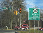
to Route 49 in Upper Township
.
in Maurice River Township
, Cumberland County
, heading east on two-lane undivided Broadway Avenue. The road passes homes before crossing CR 648 and becoming Weatherby Road. The route crosses an abandoned railroad line as it leaves Port Elizabeth and passes a patch of farmland before entering dense forests. CR 548 continues through the forests for several more miles as it enters Cape May County
, briefly running through Dennis Township
before crossing into Upper Township
and passing through the Belleplain State Forest
. CR 548 passes some farms and reaches an intersection with CR 605 before it comes to its eastern terminus at Route 49.
 County Route 548 used to continue farther west, following New Jersey Route 47 and Cumberland County Routes 670 and 649 to County Route 553
in Port Norris
.

County highway
A county highway is a road in the United States and in the Canadian province of Ontario that is designated and/or maintained by the county highway department...
in the U.S. state
U.S. state
A U.S. state is any one of the 50 federated states of the United States of America that share sovereignty with the federal government. Because of this shared sovereignty, an American is a citizen both of the federal entity and of his or her state of domicile. Four states use the official title of...
of New Jersey
New Jersey
New Jersey is a state in the Northeastern and Middle Atlantic regions of the United States. , its population was 8,791,894. It is bordered on the north and east by the state of New York, on the southeast and south by the Atlantic Ocean, on the west by Pennsylvania and on the southwest by Delaware...
. The highway extends 9.18 miles (14.8 km) from Delsea Drive (Route 47 in Maurice River Township
Maurice River Township, New Jersey
Maurice River Township is a township in Cumberland County, New Jersey, United States. It is part of the Vineland-Millville- Bridgeton Primary Metropolitan Statistical Area for statistical purposes...
to Route 49 in Upper Township
Upper Township, New Jersey
Upper Township is a large township in Cape May County, New Jersey, United States. It is part of the Ocean City Metropolitan Statistical Area. The township population was 12,115 as of the United States 2000 Census...
.
Route description
CR 548 begins at an intersection with Route 47 in the community of Port ElizabethPort Elizabeth, New Jersey
Port Elizabeth is an unincorporated area within Maurice River Township, Cumberland County, New Jersey. The area is served as United States Postal Service ZIP code 08348....
in Maurice River Township
Maurice River Township, New Jersey
Maurice River Township is a township in Cumberland County, New Jersey, United States. It is part of the Vineland-Millville- Bridgeton Primary Metropolitan Statistical Area for statistical purposes...
, Cumberland County
Cumberland County, New Jersey
Cumberland County is a county located in the U.S. state of New Jersey. As of the 2010 Census, the population is 156,898. Its county seat is Bridgeton. Cumberland County is named for Prince William, Duke of Cumberland....
, heading east on two-lane undivided Broadway Avenue. The road passes homes before crossing CR 648 and becoming Weatherby Road. The route crosses an abandoned railroad line as it leaves Port Elizabeth and passes a patch of farmland before entering dense forests. CR 548 continues through the forests for several more miles as it enters Cape May County
Cape May County, New Jersey
-Climate:Being the southernmost point in New Jersey, Cape May has fairly mild wintertime temperatures. Contrary to that, the summertime has lower temperatures than most places in the state, making the county a popular place to escape the heat. It is in zone 7a/7b, which is the same as parts of...
, briefly running through Dennis Township
Dennis Township, New Jersey
Dennis Township is a township in Cape May County, New Jersey, United States. It is part of the Ocean City Metropolitan Statistical Area. The township population was 6,492 as of the United States 2000 Census...
before crossing into Upper Township
Upper Township, New Jersey
Upper Township is a large township in Cape May County, New Jersey, United States. It is part of the Ocean City Metropolitan Statistical Area. The township population was 12,115 as of the United States 2000 Census...
and passing through the Belleplain State Forest
Belleplain State Forest
Belleplain State Forest is a New Jersey State Forest in northern Cape May County and eastern Cumberland County. It has many young pine, oak and Atlantic white cedar trees, having better soil than the northern Pine Barrens...
. CR 548 passes some farms and reaches an intersection with CR 605 before it comes to its eastern terminus at Route 49.
History
County Route 553 (New Jersey)
County Route 553, abbreviated CR 553, is a county highway in the U.S. state of New Jersey. The highway extends from Hands Landing Road/Ogden Avenue in Commercial Township to Broadway in Deptford Township.-Cumberland County:...
in Port Norris
Port Norris, New Jersey
Port Norris is a census-designated place and unincorporated area located within Commercial Township, in Cumberland County, New Jersey. It is part of the Vineland-Millville- Bridgeton Primary Metropolitan Statistical Area for statistical purposes...
.
Major intersections
See also