
.gif)
Route 20 (Japan)
Encyclopedia
National highways of Japan
Japan has a nationwide system of distinct from the expressways. The Ministry of Land, Infrastructure and Transport and other government agencies administer the national highways. Beginning in 1952, Japan classified these as Class 1 or Class 2. Class 1 highways had one- or two-digit numbers, while...
connecting Tokyo
Tokyo
, ; officially , is one of the 47 prefectures of Japan. Tokyo is the capital of Japan, the center of the Greater Tokyo Area, and the largest metropolitan area of Japan. It is the seat of the Japanese government and the Imperial Palace, and the home of the Japanese Imperial Family...
and Shiojiri
Shiojiri, Nagano
is a city located in Nagano, Japan. Its name literally means "the end of salt".-History:Municipal Area Changes* April 1, 1927-The village of Shiojiri gained town status....
, Nagano prefecture
Nagano Prefecture
is a prefecture of Japan located in the Chūbu region of the island of Honshū. The capital is the city of Nagano.- History :Nagano was formerly known as the province of Shinano...
in Japan
Japan
Japan is an island nation in East Asia. Located in the Pacific Ocean, it lies to the east of the Sea of Japan, China, North Korea, South Korea and Russia, stretching from the Sea of Okhotsk in the north to the East China Sea and Taiwan in the south...
. Originating at Nihonbashi
Nihonbashi
, or Nihombashi, is a business district of Chūō, Tokyo, Japan which grew up around the bridge of the same name which has linked two sides of the Nihonbashi River at this site since the 17th century. The first wooden bridge was completed in 1603, and the current bridge made of stone dates from 1911...
in Chūō, Tokyo
Chuo, Tokyo
is one of the 23 special wards that form the heart of Tokyo, Japan. The ward refers to itself as Chūō City in English.Its Japanese name literally means "Central Ward," and it is historically the main commercial center of Tokyo, although Shinjuku has risen to challenge it since the end of World War II...
, it passes through Shinjuku
Shinjuku, Tokyo
is one of the 23 special wards of Tokyo, Japan. It is a major commercial and administrative center, housing the busiest train station in the world and the Tokyo Metropolitan Government Building, the administration center for the government of Tokyo.As of 2008, the ward has an estimated population...
and four other wards, and then seven cities, including Hachiōji
Hachioji, Tokyo
is a city located in Tokyo, Japan, about 40 kilometers west of the center of the special wards of Tokyo.As of January 1, 2010, the city has an estimated population of 551,901 and a population density of 2,962.27/km². The total area is 186.31 km². It is the eighth largest city in the...
in Tokyo. It follows a westward route into Kanagawa Prefecture
Kanagawa Prefecture
is a prefecture located in the southern Kantō region of Japan. The capital is Yokohama. Kanagawa is part of the Greater Tokyo Area.-History:The prefecture has some archaeological sites going back to the Jōmon period...
, passing through the city of Sagamihara
Sagamihara, Kanagawa
is a city located in north central Kanagawa Prefecture, bordering Tokyo, Japan. It is the third most populous city in the prefecture, after Yokohama and Kawasaki, and the fifth most populous suburb of Greater Tokyo. Its northern neighbor is Machida, with which a cross-prefectural merger has been...
and one town. Continuing into Yamanashi Prefecture
Yamanashi Prefecture
is a prefecture of Japan located in the Chūbu region of the island of Honshū. The capital is the city of Kōfu.-Pre-history to the 14th century:People have been living in the Yamanashi area for about 30,000 years...
, the highway passes through nine cities and towns, among them the prefectural capital
Prefectures of Japan
The prefectures of Japan are the country's 47 subnational jurisdictions: one "metropolis" , Tokyo; one "circuit" , Hokkaidō; two urban prefectures , Osaka and Kyoto; and 43 other prefectures . In Japanese, they are commonly referred to as...
of Kofu
Kofu, Yamanashi
is the capital city of Yamanashi Prefecture in Japan.As of May 1, 2011, the city had a estimate population of 197,540, with 85,794 households. The total area is 212.41 km².-History:Kōfu's name means "capital of Kai Province"...
. In Nagano Prefecture, Route 20 passes through five cities and towns before entering Shiojiri
Shiojiri, Nagano
is a city located in Nagano, Japan. Its name literally means "the end of salt".-History:Municipal Area Changes* April 1, 1927-The village of Shiojiri gained town status....
, where it terminates at the intersection of Routes 19 and 153
Route 153 (Japan)
National Route 153 is a national highway of Japan connecting Higashi-ku, Nagoya and Shiojiri, Nagano in Japan, with a total length of 213.4 km ....
. The highway is 225.0 km long.
Route 20 is the successor to the Kōshū Kaidō
Kaido
were ancient roads in Japan dating from the Edo period. Major examples include the Edo Five Routes, all of which started at Edo...
, an Edo period
Edo period
The , or , is a division of Japanese history which was ruled by the shoguns of the Tokugawa family, running from 1603 to 1868. The political entity of this period was the Tokugawa shogunate....
highway connecting the shogunal
Tokugawa shogunate
The Tokugawa shogunate, also known as the and the , was a feudal regime of Japan established by Tokugawa Ieyasu and ruled by the shoguns of the Tokugawa family. This period is known as the Edo period and gets its name from the capital city, Edo, which is now called Tokyo, after the name was...
capital of Edo
Edo
, also romanized as Yedo or Yeddo, is the former name of the Japanese capital Tokyo, and was the seat of power for the Tokugawa shogunate which ruled Japan from 1603 to 1868...
and Kofu, then the principal city in Kai Province
Kai Province
, also known as , is an old province in Japan in the area of Yamanashi Prefecture. It lies in central Honshū, west of Tokyo, in a landlocked mountainous region that includes Mount Fuji along its border with Shizuoka Prefecture....
(or Kōshū, as it was also known). Parts of it still bear the old name.
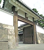
The road's course passes the Sakurada Gate of the Tokyo Imperial Palace
Kokyo
is the main residence of the Emperor of Japan. It is a large park-like area located in the Chiyoda area of Tokyo close to Tokyo Station and contains several buildings including the main palace , the emperor left Kyoto Imperial Palace for Tokyo...
. Shinjuku Station
Shinjuku Station
is a train station located in Shinjuku and Shibuya wards in Tokyo, Japan.Serving as the main connecting hub for rail traffic between central Tokyo and its western suburbs on inter-city rail, commuter rail and metro lines, the station was used by an average of 3.64 million people per day in 2007,...
is on Route 20. The marathon
Marathon
The marathon is a long-distance running event with an official distance of 42.195 kilometres , that is usually run as a road race...
course of the Tokyo Olympics
1964 Summer Olympics
The 1964 Summer Olympics, officially known as the Games of the XVIII Olympiad, was an international multi-sport event held in Tokyo, Japan in 1964. Tokyo had been awarded with the organization of the 1940 Summer Olympics, but this honor was subsequently passed to Helsinki because of Japan's...
included parts of Route 20.
History
- 1952-12-04 - First Class National Highway 20 (from TokyoTokyo, ; officially , is one of the 47 prefectures of Japan. Tokyo is the capital of Japan, the center of the Greater Tokyo Area, and the largest metropolitan area of Japan. It is the seat of the Japanese government and the Imperial Palace, and the home of the Japanese Imperial Family...
to Shiojiri, NaganoShiojiri, Naganois a city located in Nagano, Japan. Its name literally means "the end of salt".-History:Municipal Area Changes* April 1, 1927-The village of Shiojiri gained town status....
) - 1965-04-01 - General National Highway 20 (from TokyoTokyo, ; officially , is one of the 47 prefectures of Japan. Tokyo is the capital of Japan, the center of the Greater Tokyo Area, and the largest metropolitan area of Japan. It is the seat of the Japanese government and the Imperial Palace, and the home of the Japanese Imperial Family...
to Shiojiri, NaganoShiojiri, Naganois a city located in Nagano, Japan. Its name literally means "the end of salt".-History:Municipal Area Changes* April 1, 1927-The village of Shiojiri gained town status....
)
Overlapping sections
- From Nihonbashi to Chiyoda (Sakuradamon intersection): Route 1Route 1 (Japan)National Route 1 is a major highway on the island of Honshū in Japan. It connects Chūō, Tokyo in the Kantō region with the city of Osaka, Osaka Prefecture in the Kansai region, passing through the Chūbu region en route. It follows the old Tōkaidō westward from Tokyo to Kyoto, and the old Kyo Kaidō...
- In Hachioji, from Yokamachi intersection to Yawatamachi intersection: Route 16Route 16 (Japan)National Route 16 is a national highway in Japan. A beltway around Tokyo, it links the major prefectural capital cities of Yokohama , Saitama , and Chiba as well as Hachiōji . It also serves Yokosuka and Sagamihara , Kasukabe , and Kisarazu...
- In Otsuki, from intersection to Otsuki-bashi east intersection: Route 139Route 139 (Japan)National Route 139 is a national highway of Japan connecting Fuji, Shizuoka and Okutama, Tokyo in Japan, with a total length of 134.4 km ....
- From Kai (Ryuo-rittai intersection) to Nirasaki (Funayama-bashi kita intersection): Route 52
Intersects with
- TokyoTokyo, ; officially , is one of the 47 prefectures of Japan. Tokyo is the capital of Japan, the center of the Greater Tokyo Area, and the largest metropolitan area of Japan. It is the seat of the Japanese government and the Imperial Palace, and the home of the Japanese Imperial Family...
- Routes 4Route 4 (Japan)National Route 4 is a major highway in eastern Honshū, Japan. The longest of the ordinary highways in Japan, it originates in Chūō, Tokyo and stretches north for 743.6 km to the city of Aomori in Aomori Prefecture. From Saitama Prefecture to Iwate Prefecture, it parallels the Tōhoku...
and 15; at the origin, in Nihonbashi (Route 4 overlaps with 6Route 6 (Japan)National Route 6 is a Japanese highway which goes from Tokyo via Mito and Hitachi in Ibaraki Prefecture towards Sendai. The route traces the old Mito Kaidō from Tokyo to Mito...
, 14 and 17Route 17 (Japan)National Route 17 is a highway on the island of Honshū in Japan. It originates at Nihonbashi in Chūō, Tokyo and terminates in the city of Niigata , where it meets Routes 7, 8, 49, 113 and 116)....
) - Route 1Route 1 (Japan)National Route 1 is a major highway on the island of Honshū in Japan. It connects Chūō, Tokyo in the Kantō region with the city of Osaka, Osaka Prefecture in the Kansai region, passing through the Chūbu region en route. It follows the old Tōkaidō westward from Tokyo to Kyoto, and the old Kyo Kaidō...
; from Nihonbashi to Chiyoda - Route 246Route 246 (Japan)is a major highway on the island of Honshū in Japan. It originates in Chiyoda, Tokyo and terminates in Numazu, Shizuoka. In and near Tokyo, it parallels the routes of the Dai-ichi Keihin, Dai-ni Keihin, and Tomei Expressways, the Tōkyū Den-en-toshi Line, Odakyu Odawara Line, Gotemba Line, and...
; at Chiyoda - Chofu IC, Chuo ExpresswayChuo ExpresswayThe is a national expressway in Japan. It is owned and operated by Central Nippon Expressway Company.-Naming:Officially the expressway is designated as the Chūō Expressway Nishinomiya Route , the Chūō Expressway Nagano Route , and the Chūō Expressway Fujiyoshida Route The (lit. Central...
at Chōfu - Kunitachi-Fuchu IC, Chuo Expressway at Kunitachi
- Route 16Route 16 (Japan)National Route 16 is a national highway in Japan. A beltway around Tokyo, it links the major prefectural capital cities of Yokohama , Saitama , and Chiba as well as Hachiōji . It also serves Yokosuka and Sagamihara , Kasukabe , and Kisarazu...
; at Hachioji
- Routes 4
- Kanagawa PrefectureKanagawa Prefectureis a prefecture located in the southern Kantō region of Japan. The capital is Yokohama. Kanagawa is part of the Greater Tokyo Area.-History:The prefecture has some archaeological sites going back to the Jōmon period...
- Route 412Route 412 (Japan)National Route 412 is a national highway of Japan connecting Hiratsuka, Kanagawa and Sagamihara, Kanagawa in Japan, with a total length of 48.6 km ....
and Sagamiko-Higashi Exit, Chuo Expressway; at Sagamihara - Sagamiko IC, Chuo Expressway at Sagamihara
- Route 412
- Yamanashi PrefectureYamanashi Prefectureis a prefecture of Japan located in the Chūbu region of the island of Honshū. The capital is the city of Kōfu.-Pre-history to the 14th century:People have been living in the Yamanashi area for about 30,000 years...
- Route 139Route 139 (Japan)National Route 139 is a national highway of Japan connecting Fuji, Shizuoka and Okutama, Tokyo in Japan, with a total length of 134.4 km ....
and Otsuki IC, Chuo Expressway; at Otsuki - Route 137Route 137 (Japan)National Route 137 is a national highway of Japan connecting Fujiyoshida, Yamanashi and Fuefuki, Yamanashi in Japan, with a total length of 30 km ....
; at Fuefuki - Routes 140Route 140 (Japan)National Route 140 is a national highway of Japan connecting Kumagaya, Saitama and Masuho, Yamanashi in Japan, with a total length of 146.6 km ....
and 358Route 358 (Japan)National Route 358 is a national highway of Japan connecting Fujikawaguchiko, Yamanashi and Kōfu, Yamanashi in Japan, with a total length of 28.5 km ....
; at Kofu - Route 52; from Kai to Nirasaki
- Route 141Route 141 (Japan)National Route 141 is a national highway of Japan connecting Nirasaki, Yamanashi and Ueda, Nagano in Japan, with a total length of 104.9 km ....
; at Nirasaki
- Route 139
- Nagano PrefectureNagano Prefectureis a prefecture of Japan located in the Chūbu region of the island of Honshū. The capital is the city of Nagano.- History :Nagano was formerly known as the province of Shinano...
- Rotues 152Route 152 (Japan)National Route 152 is a national highway of Japan connecting Ueda, Nagano and Higashi-ku, Hamamatsu in Japan, with a total length of 252.4 km ....
and 299Route 299 (Japan)National Route 299 is a national highway of Japan connecting Chino, Nagano and Iruma, Saitama in Japan, with a total length of 189.3 km ....
; at Chino - Route 142Route 142 (Japan)National Route 142 is a national highway of Japan connecting Karuizawa, Nagano and Shimosuwa, Nagano in Japan, with a total length of 77.3 km ....
; at Shimosuwa - Routes 19 and 153Route 153 (Japan)National Route 153 is a national highway of Japan connecting Higashi-ku, Nagoya and Shiojiri, Nagano in Japan, with a total length of 213.4 km ....
; at the terminus, in Shiojiri
- Rotues 152