
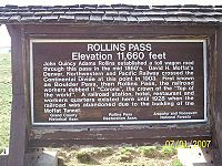
Rollins Pass
Encyclopedia
Rollins Pass is a high mountain pass
in the Rocky Mountains
of north-central Colorado
in the United States
. The pass is located on the continental divide
at the crest of the Front Range
southwest of Boulder
, at the boundary of Grand
and Boulder
counties.
, between Winter Park and Rollinsville
. The pass is traversed by two unpaved roads, mostly the former roadbed of the Denver and Salt Lake Railway
which abandoned the route in 1928 when the Moffat Tunnel
opened to replace it. This high altitude railroad was known as the Moffat Road. The Boulder Wagon Road, which predates the rail route, also uses Rollins Pass to cross the Continental Divide.
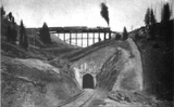
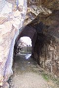
The majority of the route of the Moffat Road is open, except for a long, deteriorated trestle just east of the pass, and sections leading to the Needle's Eye Tunnel, a short high altitude railroad tunnel
which was closed in 1990 after a rock fell from the ceiling injuring a Denver
firefighter. Since then, the tunnel was sealed by Boulder County and the USFS. The original Boulder Wagon Road (BWR) also goes over Rollins Pass and bypasses the Needles Eye Tunnel. The BWR is a four-wheel-drive road not suited to lower clearance two-wheel-drive vehicles. Although open prior to 2008 and in good condition, this road remains to this day a subject of much controversy between its users and some officials who want it closed. In 2002 the James Peak Wilderness and Protection Area Bill (aka Public Law 107-216) was signed into legislation by President George W. Bush and Congress. The Bill specifically created a narrow road corridor between the Indian Peaks and James Peaks Wilderness areas and states that if any of the affected counties (Grand, Gilpin or Boulder) request, the Secretary of the USDA will cooperate and assist with the repair of the Rollins Pass Road and until that time the attendant road (the BWR) will remain open to motorized use. Boulder County officials and the USFS-Boulder Ranger District have resisted the wording of the law and have closed the BWR. Both Grand and Gilpin Counties have made numerous written requests to the Secretary for the repair of Rollins Pass Road but to date there has been no repair of the road or the barricaded Needles Eye Tunnel. The reopening of the BWR, and/or repair of the Rollins Pass Road, and even the facts surrounding the 1990 accident in the tunnel, have become contentious and ongoing issues.
 Rollins pass is a popular recreational location for its spectacular views, wildflowers, hiking
, photography
, and high clearance vehicles during the summer months. The road up to the pass on the western side from Winter Park is in good condition starting from US Route 40 in Winter Park
, and can be traveled by regular 2wd automobile in the summer in good weather, or by snowmobile
in the winter.
The only access to the actual Rollins Pass from the east is via the disputed 4wd BWR due to the tunnel closure. From the Peak-to-Peak Highway (State Highway 119
) at Rollinsville
East Portal Road runs west, parallel to South Boulder Creek and the current Union Pacific Railroad
tracks, to the entrance to the Moffat Tunnel at East Portal, and then rises on the abandoned railroad grade via the Moffat Road to the closed Needle's Eye Tunnel. From Rollinsville to East Portal, the road is an all-weather gravel road which can be traveled by regular automobiles. However, beyond East Portal it is very rough due to lack of maintenance. Although not steep or loose, it is recommended that a high clearance 4wd vehicle be used. This section of road is open to just beyond Jenny Lake where there is a barricade approximately one half mile before the Needles Eye Tunnel. The road is open for hiking beyond the barricade to the entrance of the closed tunnel, and a rough trail continues above the tunnel for those on foot to bypass the closure.
 The pass provides a route over the Continental Divide between the Atlantic Ocean
watershed of South Boulder Creek (in the basin of the South Platte River
) with the Pacific Ocean
watershed of the Fraser River
, a tributary of the Colorado River. Native Americans were the first travelers over Rollins Pass which is a natural low crossing over the Continental Divide and beyond. The first recorded use of the pass by a wagon train was in 1862. It is named for John Rollins, who constructed a toll wagon road over the pass in the 1870s, providing a route between the Colorado Front Range
and Middle Park
. The pass was used heavily in the late 19th century by settlers to drive cattle over the continental divide to Middle Park, and at one time as many as 12,000 cattle at a time were driven over the pass .
, a Denver
banker, established the Denver, Northwestern and Pacific Railway with the intention of building a railroad over the Front Range in the vicinity of the pass. The line was known as the Moffat Road, ran 23 miles over the pass, with a 4% grade along many stretches, and was one of the highest adhesion (non-cog) railroads ever constructed in North America
. Along this route is the closed Needles Eye Tunnel (not to be confused with lower and longer Moffat Tunnel constructed some 30 years later). Other notable landmarks on the route included Riflesight Notch, a loop where trains crossed over a trestle, went through a loop, and passed through a tunnel underneath the trestle. A small rail stop called Corona was established at the top of the pass, with a restaurant and lodging, which allowed workers to help keep the rail line free of snow in the winter. Despite the fact that the line was enclosed in almost continuous sheds near the top of the pass, trains were often stranded for several days during heavy winter snowstorms because the snow could fall through the wood planking of the sheds. It was these heavy snowstorms that were the demise of the Moffat Road and the incentive for construction of a tunnel. Because the route was intended to be a temporary, it was constructed as cheaply as possible - using high trestles, 4% grades and switchbacks instead of high fills, iron bridges, and tunnels. Because of the high-altitude nature of the route, the route utilized wyes instead of turntables to turn locomotives around.
Much of the right-of-way is still intact, although some of the trestles have collapsed. A small wye on the passing siding at the eastern portal of the Moffat Tunnel marks the spot where the Rollins Pass line would have merged into the modern route if it still existed. This wye is currently utilized for short-turning some services.
The first attempt to tunnel under Rollins Pass met with both engineering and financial failure, and its remains can still be seen at Yankee Doodle Lake. The second attempt, to built a longer tunnel at a lower elevation, was better planned and financed. Although Moffat did not live to see his tunnel completed, his enterprise was continued under a different name, and the Moffat Tunnel
opened just south of the pass on February 26, 1928. The new tunnel route became part of the mainline across Colorado of the Denver and Salt Lake Railroad, later the Denver and Rio Grande Railroad, and now the Union Pacific Railroad
. The Moffat Tunnel continues to serve as the route for the Amtrak
California Zephyr
between Chicago, Illinois and Emeryville, California
, and until summer 2009, for Ski Train
passengers between Denver and Winter Park.
The Rollins Pass tracks were not immediately demolished after the tunnel opened. In fact, they had to remain usable as an emergency route. It was used as such in July of 1928 when several wooden planks inside the tunnel collapsed. Permission to rip up the rails on Rollins Pass was not granted by the ICC
until 1935. Sometime in the seven years between when the line was abandoned and when the tracks were ripped up, a mysterious fire destroyed several of the snowsheds near the summit and the hotel at Corona.
7KCAB were killed on impact.
Mountain pass
A mountain pass is a route through a mountain range or over a ridge. If following the lowest possible route, a pass is locally the highest point on that route...
in the Rocky Mountains
Rocky Mountains
The Rocky Mountains are a major mountain range in western North America. The Rocky Mountains stretch more than from the northernmost part of British Columbia, in western Canada, to New Mexico, in the southwestern United States...
of north-central Colorado
Colorado
Colorado is a U.S. state that encompasses much of the Rocky Mountains as well as the northeastern portion of the Colorado Plateau and the western edge of the Great Plains...
in the United States
United States
The United States of America is a federal constitutional republic comprising fifty states and a federal district...
. The pass is located on the continental divide
Continental divide
A continental divide is a drainage divide on a continent such that the drainage basin on one side of the divide feeds into one ocean or sea, and the basin on the other side either feeds into a different ocean or sea, or else is endorheic, not connected to the open sea...
at the crest of the Front Range
Front Range
The Front Range is a mountain range of the Southern Rocky Mountains of North America located in the north-central portion of the U.S. State of Colorado and southeastern portion of the U.S. State of Wyoming. It is the first mountain range encountered moving west along the 40th parallel north across...
southwest of Boulder
Boulder, Colorado
Boulder is the county seat and most populous city of Boulder County and the 11th most populous city in the U.S. state of Colorado. Boulder is located at the base of the foothills of the Rocky Mountains at an elevation of...
, at the boundary of Grand
Grand County, Colorado
Grand County is the 21st largest of the 64 counties of the State of Colorado of the United States. The county population was 12,442 at U.S. Census 2000...
and Boulder
Boulder County, Colorado
Boulder County is the sixth most populous of the 64 counties of the state of Colorado of the United States. The county seat is Boulder. The most populous municipality in the county and the county seat is the City of Boulder...
counties.
Description
Rollins Pass (a.k.a. Corona Pass) sits approximately 5 miles east and above the popular ski areas around Winter ParkWinter Park, Colorado
Winter Park is a Home Rule Municipality in Grand County, Colorado, United States. The town population was 662 at the 2000 census, although tourists and seasonal workers significantly increase the population....
, between Winter Park and Rollinsville
Rollinsville, Colorado
Rollinsville is a census-designated place and a U.S. Post Office located in Gilpin County, Colorado, United States. The population as of the 2010 Census was 181.It is located in the mountains southwest of the city of Boulder, on the flank of a hill above South Boulder Creek along State Highway 119...
. The pass is traversed by two unpaved roads, mostly the former roadbed of the Denver and Salt Lake Railway
Denver and Salt Lake Railway
The Denver, Northwestern and Pacific Railway was a U.S. railroad company incorporated on July 18, 1902, by David H. Moffat, Walter S. Cheesman, William Gray Evans, Charles J. Hughes, Jr., George E. Ross-Lewin, S.M. Perry and Frank P. Gibson...
which abandoned the route in 1928 when the Moffat Tunnel
Moffat Tunnel
The Moffat Tunnel is a railroad and water tunnel that cuts through the Continental Divide in north-central Colorado. Named after Colorado railroad pioneer David Moffat, the tunnel's first railroad traffic passed through in February 1928....
opened to replace it. This high altitude railroad was known as the Moffat Road. The Boulder Wagon Road, which predates the rail route, also uses Rollins Pass to cross the Continental Divide.
The majority of the route of the Moffat Road is open, except for a long, deteriorated trestle just east of the pass, and sections leading to the Needle's Eye Tunnel, a short high altitude railroad tunnel
Tunnel
A tunnel is an underground passageway, completely enclosed except for openings for egress, commonly at each end.A tunnel may be for foot or vehicular road traffic, for rail traffic, or for a canal. Some tunnels are aqueducts to supply water for consumption or for hydroelectric stations or are sewers...
which was closed in 1990 after a rock fell from the ceiling injuring a Denver
Denver, Colorado
The City and County of Denver is the capital and the most populous city of the U.S. state of Colorado. Denver is a consolidated city-county, located in the South Platte River Valley on the western edge of the High Plains just east of the Front Range of the Rocky Mountains...
firefighter. Since then, the tunnel was sealed by Boulder County and the USFS. The original Boulder Wagon Road (BWR) also goes over Rollins Pass and bypasses the Needles Eye Tunnel. The BWR is a four-wheel-drive road not suited to lower clearance two-wheel-drive vehicles. Although open prior to 2008 and in good condition, this road remains to this day a subject of much controversy between its users and some officials who want it closed. In 2002 the James Peak Wilderness and Protection Area Bill (aka Public Law 107-216) was signed into legislation by President George W. Bush and Congress. The Bill specifically created a narrow road corridor between the Indian Peaks and James Peaks Wilderness areas and states that if any of the affected counties (Grand, Gilpin or Boulder) request, the Secretary of the USDA will cooperate and assist with the repair of the Rollins Pass Road and until that time the attendant road (the BWR) will remain open to motorized use. Boulder County officials and the USFS-Boulder Ranger District have resisted the wording of the law and have closed the BWR. Both Grand and Gilpin Counties have made numerous written requests to the Secretary for the repair of Rollins Pass Road but to date there has been no repair of the road or the barricaded Needles Eye Tunnel. The reopening of the BWR, and/or repair of the Rollins Pass Road, and even the facts surrounding the 1990 accident in the tunnel, have become contentious and ongoing issues.
Hiking
Hiking is an outdoor activity which consists of walking in natural environments, often in mountainous or other scenic terrain. People often hike on hiking trails. It is such a popular activity that there are numerous hiking organizations worldwide. The health benefits of different types of hiking...
, photography
Photography
Photography is the art, science and practice of creating durable images by recording light or other electromagnetic radiation, either electronically by means of an image sensor or chemically by means of a light-sensitive material such as photographic film...
, and high clearance vehicles during the summer months. The road up to the pass on the western side from Winter Park is in good condition starting from US Route 40 in Winter Park
Winter Park, Colorado
Winter Park is a Home Rule Municipality in Grand County, Colorado, United States. The town population was 662 at the 2000 census, although tourists and seasonal workers significantly increase the population....
, and can be traveled by regular 2wd automobile in the summer in good weather, or by snowmobile
Snowmobile
A snowmobile, also known in some places as a snowmachine, or sled,is a land vehicle for winter travel on snow. Designed to be operated on snow and ice, they require no road or trail. Design variations enable some machines to operate in deep snow or forests; most are used on open terrain, including...
in the winter.
The only access to the actual Rollins Pass from the east is via the disputed 4wd BWR due to the tunnel closure. From the Peak-to-Peak Highway (State Highway 119
Colorado State Highway 119
State Highway 119 is a long state highway in north central Colorado. It extends in a southwest to northeast direction, from a junction with US Route 6 in Clear Creek Canyon between Golden and Idaho Springs to a junction with I-25 east of Longmont....
) at Rollinsville
Rollinsville, Colorado
Rollinsville is a census-designated place and a U.S. Post Office located in Gilpin County, Colorado, United States. The population as of the 2010 Census was 181.It is located in the mountains southwest of the city of Boulder, on the flank of a hill above South Boulder Creek along State Highway 119...
East Portal Road runs west, parallel to South Boulder Creek and the current Union Pacific Railroad
Union Pacific Railroad
The Union Pacific Railroad , headquartered in Omaha, Nebraska, is the largest railroad network in the United States. James R. Young is president, CEO and Chairman....
tracks, to the entrance to the Moffat Tunnel at East Portal, and then rises on the abandoned railroad grade via the Moffat Road to the closed Needle's Eye Tunnel. From Rollinsville to East Portal, the road is an all-weather gravel road which can be traveled by regular automobiles. However, beyond East Portal it is very rough due to lack of maintenance. Although not steep or loose, it is recommended that a high clearance 4wd vehicle be used. This section of road is open to just beyond Jenny Lake where there is a barricade approximately one half mile before the Needles Eye Tunnel. The road is open for hiking beyond the barricade to the entrance of the closed tunnel, and a rough trail continues above the tunnel for those on foot to bypass the closure.
Atlantic Ocean
The Atlantic Ocean is the second-largest of the world's oceanic divisions. With a total area of about , it covers approximately 20% of the Earth's surface and about 26% of its water surface area...
watershed of South Boulder Creek (in the basin of the South Platte River
South Platte River
The South Platte River is one of the two principal tributaries of the Platte River and itself a major river of the American Midwest and the American Southwest/Mountain West, located in the U.S. states of Colorado and Nebraska...
) with the Pacific Ocean
Pacific Ocean
The Pacific Ocean is the largest of the Earth's oceanic divisions. It extends from the Arctic in the north to the Southern Ocean in the south, bounded by Asia and Australia in the west, and the Americas in the east.At 165.2 million square kilometres in area, this largest division of the World...
watershed of the Fraser River
Fraser River (Colorado)
The Fraser River is a tributary of the Colorado River, approximately long, in north central Colorado in the United States. It drains large portion of the Middle Park basin in Grand County in the Rocky Mountains west of Boulder and southwest of Rocky Mountain National Park. It rises at the...
, a tributary of the Colorado River. Native Americans were the first travelers over Rollins Pass which is a natural low crossing over the Continental Divide and beyond. The first recorded use of the pass by a wagon train was in 1862. It is named for John Rollins, who constructed a toll wagon road over the pass in the 1870s, providing a route between the Colorado Front Range
Colorado Front Range
The Colorado Front Range is a colloquial geographic term for the most populous region of the state of Colorado in the United States. The area is located just east of the foothills of the Front Range, aligned in a north-south configuration on the western edge of the Great Plains, where they meet the...
and Middle Park
Middle Park (Colorado basin)
Middle Park is a high basin in the Rocky Mountains of north-central Colorado in the United States. It is located in Grand County, on the southwest slope of Rocky Mountain National Park, approximately 50 miles west of Boulder.-Description:The basin surrounds the headwaters of the Colorado River...
. The pass was used heavily in the late 19th century by settlers to drive cattle over the continental divide to Middle Park, and at one time as many as 12,000 cattle at a time were driven over the pass .
Rollins Pass as a railroad line
In the early 20th century, David MoffatDavid Moffat
David Halliday Moffat was an American financier and industrialist.Moffat was one of Denver's most important financiers and industrialists in late 19th and early 20th century Colorado, and he was responsible for the development of the Middle Park area. He served as president, treasurer and as a...
, a Denver
Denver, Colorado
The City and County of Denver is the capital and the most populous city of the U.S. state of Colorado. Denver is a consolidated city-county, located in the South Platte River Valley on the western edge of the High Plains just east of the Front Range of the Rocky Mountains...
banker, established the Denver, Northwestern and Pacific Railway with the intention of building a railroad over the Front Range in the vicinity of the pass. The line was known as the Moffat Road, ran 23 miles over the pass, with a 4% grade along many stretches, and was one of the highest adhesion (non-cog) railroads ever constructed in North America
North America
North America is a continent wholly within the Northern Hemisphere and almost wholly within the Western Hemisphere. It is also considered a northern subcontinent of the Americas...
. Along this route is the closed Needles Eye Tunnel (not to be confused with lower and longer Moffat Tunnel constructed some 30 years later). Other notable landmarks on the route included Riflesight Notch, a loop where trains crossed over a trestle, went through a loop, and passed through a tunnel underneath the trestle. A small rail stop called Corona was established at the top of the pass, with a restaurant and lodging, which allowed workers to help keep the rail line free of snow in the winter. Despite the fact that the line was enclosed in almost continuous sheds near the top of the pass, trains were often stranded for several days during heavy winter snowstorms because the snow could fall through the wood planking of the sheds. It was these heavy snowstorms that were the demise of the Moffat Road and the incentive for construction of a tunnel. Because the route was intended to be a temporary, it was constructed as cheaply as possible - using high trestles, 4% grades and switchbacks instead of high fills, iron bridges, and tunnels. Because of the high-altitude nature of the route, the route utilized wyes instead of turntables to turn locomotives around.
Much of the right-of-way is still intact, although some of the trestles have collapsed. A small wye on the passing siding at the eastern portal of the Moffat Tunnel marks the spot where the Rollins Pass line would have merged into the modern route if it still existed. This wye is currently utilized for short-turning some services.
The first attempt to tunnel under Rollins Pass met with both engineering and financial failure, and its remains can still be seen at Yankee Doodle Lake. The second attempt, to built a longer tunnel at a lower elevation, was better planned and financed. Although Moffat did not live to see his tunnel completed, his enterprise was continued under a different name, and the Moffat Tunnel
Moffat Tunnel
The Moffat Tunnel is a railroad and water tunnel that cuts through the Continental Divide in north-central Colorado. Named after Colorado railroad pioneer David Moffat, the tunnel's first railroad traffic passed through in February 1928....
opened just south of the pass on February 26, 1928. The new tunnel route became part of the mainline across Colorado of the Denver and Salt Lake Railroad, later the Denver and Rio Grande Railroad, and now the Union Pacific Railroad
Union Pacific Railroad
The Union Pacific Railroad , headquartered in Omaha, Nebraska, is the largest railroad network in the United States. James R. Young is president, CEO and Chairman....
. The Moffat Tunnel continues to serve as the route for the Amtrak
Amtrak
The National Railroad Passenger Corporation, doing business as Amtrak , is a government-owned corporation that was organized on May 1, 1971, to provide intercity passenger train service in the United States. "Amtrak" is a portmanteau of the words "America" and "track". It is headquartered at Union...
California Zephyr
California Zephyr
The California Zephyr is a long passenger train route operated by Amtrak in the midwestern and western United States.It runs from Chicago, Illinois, in the east to Emeryville, California, in the west, passing through the states of Illinois, Iowa, Nebraska, Colorado, Utah, Nevada, and California...
between Chicago, Illinois and Emeryville, California
Emeryville, California
Emeryville is a small city located in Alameda County, California, in the United States. It is located in a corridor between the cities of Berkeley and Oakland, extending to the shore of San Francisco Bay. Its proximity to San Francisco, the Bay Bridge, the University of California, Berkeley, and...
, and until summer 2009, for Ski Train
Ski Train
The Ski Train was a seasonal passenger railroad operated by Rio Grande Scenic Railroad in the period 1940-2009. Starting in 1988, the train was operated by the Ansco Investment Company, which had in turn purchased the Ski Train franchise from the Denver and Rio Grande Western Railroad in that...
passengers between Denver and Winter Park.
The Rollins Pass tracks were not immediately demolished after the tunnel opened. In fact, they had to remain usable as an emergency route. It was used as such in July of 1928 when several wooden planks inside the tunnel collapsed. Permission to rip up the rails on Rollins Pass was not granted by the ICC
ICC
-Political:* International Control Commission, which oversaw the 1954 Geneva Accords ending the First Indochina War* International Communist Current, a communist organization* Interstate Commerce Commission, a now defunct US Government regulatory body...
until 1935. Sometime in the seven years between when the line was abandoned and when the tracks were ripped up, a mysterious fire destroyed several of the snowsheds near the summit and the hotel at Corona.
Recent events
On July 30, 2006, a single engine airplane on its way to Boulder crashed on Rollins Pass. The two occupants of the 1969 CitabriaCitabria
The Citabria is a light single-engine, two-seat, fixed conventional gear airplane which entered production in the United States in 1964. Designed for flight training, utility, and personal use, it is capable of sustaining aerobatic stresses from +5g to -2g...
7KCAB were killed on impact.