
Rollinsville, Colorado
Encyclopedia
Rollinsville is a census-designated place
and a U.S. Post Office
located in Gilpin County
, Colorado
, United States
. The population as of the 2010 Census
was 181.It is located in the mountains southwest of the city of Boulder
, on the flank of a hill above South Boulder Creek along State Highway 119
between Nederland
and Black Hawk
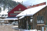
. It consists of a small cluster of residences and several businesses at the terminus of the road leading westward up to Rollins Pass
at the summit of the Front Range
. The population as of the 2010 Census
was 181.
The Rollinsville Post Office has the ZIP Code
80474.
Rollinsville was named for Joseph Rollins, a surveyor with the railroads circa 1880. Mr. Rollins and his wife, Charlotte,settled in Indianola,Nebraska area where they raised their family consisting of John, Preston, George, and Roxie. Joseph and Charlotte are buried in the Inidanola Cemetery.
Census-designated place
A census-designated place is a concentration of population identified by the United States Census Bureau for statistical purposes. CDPs are delineated for each decennial census as the statistical counterparts of incorporated places such as cities, towns and villages...
and a U.S. Post Office
United States Postal Service
The United States Postal Service is an independent agency of the United States government responsible for providing postal service in the United States...
located in Gilpin County
Gilpin County, Colorado
Gilpin County is the second least extensive of the 64 counties of the State of Colorado of the United States. Gilpin County was named after Colonel William Gilpin, the first Governor of the Territory of Colorado. The county population was 4,757 at U.S. Census 2000. The county seat is Central City...
, Colorado
Colorado
Colorado is a U.S. state that encompasses much of the Rocky Mountains as well as the northeastern portion of the Colorado Plateau and the western edge of the Great Plains...
, United States
United States
The United States of America is a federal constitutional republic comprising fifty states and a federal district...
. The population as of the 2010 Census
United States Census, 2010
The Twenty-third United States Census, known as Census 2010 or the 2010 Census, is the current national census of the United States. National Census Day was April 1, 2010 and is the reference date used in enumerating individuals...
was 181.It is located in the mountains southwest of the city of Boulder
Boulder, Colorado
Boulder is the county seat and most populous city of Boulder County and the 11th most populous city in the U.S. state of Colorado. Boulder is located at the base of the foothills of the Rocky Mountains at an elevation of...
, on the flank of a hill above South Boulder Creek along State Highway 119
Colorado State Highway 119
State Highway 119 is a long state highway in north central Colorado. It extends in a southwest to northeast direction, from a junction with US Route 6 in Clear Creek Canyon between Golden and Idaho Springs to a junction with I-25 east of Longmont....
between Nederland
Nederland, Colorado
The Town of Nederland is a Statutory Town established in 1885 located near the Continental Divide and Barker Meadow Reservoir in the mountains of southwest Boulder County, Colorado....
and Black Hawk
Black Hawk, Colorado
The historic City of Black Hawk is a Home Rule Municipality located in Gilpin County, Colorado, United States. The city population was 118 at U.S. Census 2000, making Black Hawk the least populous city in Colorado...
. It consists of a small cluster of residences and several businesses at the terminus of the road leading westward up to Rollins Pass
Rollins Pass
Rollins Pass is a high mountain pass in the Rocky Mountains of north-central Colorado in the United States. The pass is located on the continental divide at the crest of the Front Range southwest of Boulder, at the boundary of Grand and Boulder counties.-Description:Rollins Pass Rollins Pass (el....
at the summit of the Front Range
Front Range
The Front Range is a mountain range of the Southern Rocky Mountains of North America located in the north-central portion of the U.S. State of Colorado and southeastern portion of the U.S. State of Wyoming. It is the first mountain range encountered moving west along the 40th parallel north across...
. The population as of the 2010 Census
United States Census, 2010
The Twenty-third United States Census, known as Census 2010 or the 2010 Census, is the current national census of the United States. National Census Day was April 1, 2010 and is the reference date used in enumerating individuals...
was 181.
The Rollinsville Post Office has the ZIP Code
ZIP Code
ZIP codes are a system of postal codes used by the United States Postal Service since 1963. The term ZIP, an acronym for Zone Improvement Plan, is properly written in capital letters and was chosen to suggest that the mail travels more efficiently, and therefore more quickly, when senders use the...
80474.
Geography
Rollinsville is located at 39°54′59"N 105°30′03"W (39.916320,-105.500851).Rollinsville was named for Joseph Rollins, a surveyor with the railroads circa 1880. Mr. Rollins and his wife, Charlotte,settled in Indianola,Nebraska area where they raised their family consisting of John, Preston, George, and Roxie. Joseph and Charlotte are buried in the Inidanola Cemetery.
See also
- State of Colorado
- Colorado cities and towns
- Colorado countiesColorado countiesThe U.S state of Colorado is divided into 64 counties. Counties are important units of government in Colorado since the state has no secondary civil subdivisions, such as townships...
- Gilpin County, ColoradoGilpin County, ColoradoGilpin County is the second least extensive of the 64 counties of the State of Colorado of the United States. Gilpin County was named after Colonel William Gilpin, the first Governor of the Territory of Colorado. The county population was 4,757 at U.S. Census 2000. The county seat is Central City...
- Gilpin County, Colorado
- Colorado metropolitan areasColorado metropolitan areasThe metropolitan areas of the State of Colorado include the urban statistical areas defined by the United States Office of Management and Budget and regions of urban population defined by other organizations.-Census statistical areas:...
- Boulder Metropolitan Statistical Area
- Denver-Aurora-Boulder Combined Statistical AreaDenver-Aurora-Boulder Combined Statistical Areathumb|300px|Map of the 12-county Denver-Aurora-Boulder Combined Statistical AreaThe Denver-Aurora-Boulder, CO Combined Statistical Area is a United States Census Bureau defined Combined Statistical Area located in the Denver region of the state of Colorado...
- North Central Colorado Urban AreaNorth Central Colorado Urban Areathumb|240px|An enlargeable map of the 13-county North Central Colorado Urban AreaThe North Central Colorado Urban Area comprises the four contiguous metropolitan statistical areas in the north central region of the State of Colorado: the Denver-Aurora Metropolitan Statistical Area, the Boulder...
- Front Range Urban CorridorFront Range Urban CorridorThe Front Range Urban Corridor is an oblong region of urban population located along the eastern face of the Southern Rocky Mountains in the U.S. states of Colorado and Wyoming. The corridor derives its name from the Front Range, the mountain range that defines the west central boundary of the...
- United States Forest ServiceUnited States Forest ServiceThe United States Forest Service is an agency of the United States Department of Agriculture that administers the nation's 155 national forests and 20 national grasslands, which encompass...
- Roosevelt National ForestRoosevelt National ForestThe Roosevelt National Forest is a National Forest located in north central Colorado. It is contiguous with the Colorado State Forest as well as the Arapaho National Forest...
- Roosevelt National Forest