
Roads in Kerala
Encyclopedia
Kerala
, southern most state of India
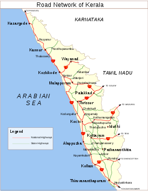
has a good network of roads. It has eight National Highways, number of State Highways and many district roads.
†NHAI maintains 444.9 km and Kerala PWD (NH) section maintains rest of the National Highways from direction of MORTH
District-wise and Category-wise Length of Roads Maintained by PWD (R&B) as on 31-3-2010
-Thrissur
-Kochi
stretch of NH 47 is a part of North-South and East-West Corridor
of the Indian highway system.There was a proposal for construction of standalone ring road/bypasses around Tiruvananthapuram City under NHDP Phase VII. NHAI stopped the feasibility study due to the present land acquisition crisis to the on coming project under NHDP – Phase-III scheme in the stretch of NH-47.
bordering with Karnataka
state and joins NH 47 at Edappally in Kochi
.
The NH 17 crosses the Chaliyar River
in Feroke, Bharathappuzha
in Kuttippuram and the Periyar River
in Varappuzha among major Kerala rivers. NH 17 takes a western sharp turn in Kuttippuram
towards the coastal front, then reaches Edappalli along the shores of Arabian Sea. It nearly merges with the Arabian Sea in Thalassery
in Kannur
District, previous instance being at Maravanathe in Karnataka, during its journey. Southern Railway
line nearly follows the NH from Thalappadi to Kuttippuram and then it separates. Major towns where Railway line touches NH 17 are Kazaragod, Kanhangad, Payyannur, Kannur, Thalassery, Mahe (Part of Union Territory
of Puthusseri, Vadakara, Koyilandi, Kozhikkode, Kuttippuram and Edappalli. There are three bypasses in NH 17 at Vadakara, Kozhikkode and Kodungallur
(Under construction) with proposals are at Kannur
, Thalassery
- Mahe, and Quilandy. The existing road from Kuttippuram to Thrissur via Edappal, Changaramkulam, Perumpilavu and Kunnamkulam, against popular belief, is not part of NH 17. This 53 KM stretch is State Highway 69
.
Connecting Towns in Kerala
Manjeshwar
- Kasaragod - Neeleswaram - Kanhangad
- Payyannur -Taliparamba
- Kannur
- Thalassery
- Mahe - Vadakara - Quilandy - Kozhikkode - Feroke
- Ramanattukara
- Kottakkal
- Valancheri -Kuttippuram
- Thrikkanapuram - Ponnani
- Chavakkad
- Thriprayar - Kodungallur
- North Paravur
- Varappuzha
- Edapally
Recent developments
421 KM of NH-17 in Kerala has been identified for the development under Phase III B of NHDP. Construction of Edapally - Varapuzha two lane in progress, next stretch will be North Paravur - Thrissur border. The construction of the Edapally Railway overbridge to be completed soon. The stretch from Kozhikkod to Kutttippuram is one of the busiest traffic corridors in Kerala, only next to Thrissur - Eranakulam stretch of National Highway 47 as it feeds traffic to commercial hub of Kochi
from northern part of Kerala, Karnataka, Goa and Maharashtra.
in Palakkad District and leaves at Kaliyikkavila in Thiruvananthapuram District. The total Length in Kerala is : 416 km (167 km part of North-South and East-West Corridor
(NS-EW; 7,300 km) by NHAI)
Connecting Towns in Kerala
Walayar
- Palakkad
- Alathur
- Vadakkencherry - Mannuthy
(Thrissur Bypass) - Chalakudy
- Angamaly
- Aluva
- Kalamassery
- Edapally(Kochi Bypass
) - Vytilla(Kochi Bypass) - Cherthala
- Alappuzha
- Haripad
- Kayamkulam
- Ochira -Karunagappally - Kollam
- Attingal
- Kazhakkuttam(Trivandrum Bypass) - Neyyattinkara
- Parassala
Recent Developments
103.6 km Cherthala to Thrissur is a four lane road and it is part of North-South and East-West Corridor
(Kochi-Walayar Section) by NHAI. 30 km Mannuthy(Thrissur)-Vadakkencherry (six lane) Phase II of NHDP 58 km Vadakkancherry-Walayar (four lane) Phase II of NHDP
230 km (Cherthala - Ochira - Kerala/TN Border)of NH-47 has been identified for the development under Phase IIIA of NHDP
National Highway 47A (India)
National Highway 47A, also known as NH 47A, is the shortest highway in the Indian Highway network. It covers a distance of 6 km (3.7 mi) between Kundannoor
and Willingdon Island
in Kochi, Kerala
.
National Highway 47C (India)
National Highway 47C or NH 47C starts at Kalamassery
(junction with NH 47
) and ends at Vallarpadam
International Container Transhipment Terminal
in Kochi
, Kerala
, India
. The total length of the highway is 17 km (10.6 mi) and runs only in Ernakulam district
of Kerala.
NH49 when properly established can connect cochin till rameshwaram-Dhanushkodi at the tip of bengal sea,very near to Another Country-Sri Lanka.
Connecting Towns in Kerala
Pettah Junction(Thrippunithura
)- Thiruvankulam
-PuthenKuriz
- Kolenchery
- Muvattupuzha
- Kothamangalam
- Neriamangalam
- Adimali
- Munnar
- Devikulam
Connecting Towns in Kerala
Ramanattukara
- Kondotty
- Malappuram
- Perinthalmanna - Mannarkkad
- Palakkad
joins NH-47
National Highway 220 (India)
Declared NH in October 2000. The highway starts at Kollam on NH 47 and terminates at Teni on NH 49 in the State of Tamil Nadu.
and Main Eastern Highway
are the largest. The respective State Highway number is displayed on the top of all milestones (black in colour in green background) on the respective road.
The Kerala State Transport Project, costing 336 million US dollars (Rs 1612 crores) - of which World Bank financing is US $ 255 million (Rs 1224 crores) and State's contribution is US $ 79.00 million(Rs 388 crores), aims to improve traffic flow and road safety on Kerala State's primary road network, and to strengthen the institutional and financial capacity of Kerala's key transport sector agencies.
Kerala
or Keralam is an Indian state located on the Malabar coast of south-west India. It was created on 1 November 1956 by the States Reorganisation Act by combining various Malayalam speaking regions....
, southern most state of India
India
India , officially the Republic of India , is a country in South Asia. It is the seventh-largest country by geographical area, the second-most populous country with over 1.2 billion people, and the most populous democracy in the world...
has a good network of roads. It has eight National Highways, number of State Highways and many district roads.
Agency Wise Distribution of Road Length during 2009-10
| Sl. No. | Name of Department/Agency | Length (KM) | Percentage |
|---|---|---|---|
| 1 | Panchayats | 104257 | 68.748 |
| 2 | PWD (R&B) | 23242 | 15.32 |
| 3 | Municipalities | 8917 | 5.88 |
| 4 | Corporation | 6644 | 4.381 |
| 5 | Forests | 4075 | 2.689 |
| 6 | Irrigation | 2664 | 1.757 |
| 7 | National Highways† | 1525 | 1.006 |
| 8 | Others (Railways,KSEB) | 328 | 0.216 |
| Total | 151652 | 100 |
†NHAI maintains 444.9 km and Kerala PWD (NH) section maintains rest of the National Highways from direction of MORTH
District-wise and Category-wise Length of Roads Maintained by PWD (R&B) as on 31-3-2010
| Sl.No | Name of District | State Highways | Major District Roads | Total |
| 1 | Thiruvananthapuram | 180.36 | 1471.942 | 1652.302 |
| 2 | Kollam | 123.79 | 1748.734 | 1872.524 |
| 3 | Alappuzha | 170.841 | 1032.485 | 1203.326 |
| 4 | Pathanamthitta | 249.194 | 1044.856 | 1294.05 |
| 5 | Kottayam | 406.531 | 2610.234 | 3016.765 |
| 6 | Idukki | 998.372 | 1402.688 | 2401.06 |
| 7 | Ernakulam | 325.206 | 1744.788 | 2069.994 |
| 8 | Thrissur | 374.033 | 1291.58 | 1665.613 |
| 9 | Palakkad | 245.987 | 1338.263 | 1584.25 |
| 10 | Malappuram | 374.764 | 1421.446 | 1796.21 |
| 11 | Kozhikode | 377.173 | 928.677 | 1305.85 |
| 12 | Wayanad | 128.955 | 637.397 | 766.352 |
| 13 | Kannur | 244.665 | 1453.196 | 1697.861 |
| 14 | Kasaragode | 141.78 | 773.772 | 915.552 |
| Total | 4341.651 | 18900.058 | 23241.709 | |
National Highways
Kerala have eight national highways and runs about 1457 km. The PalakkadPalakkad
Palakkad , formerly known as Palghat, is a municipality and a town in the state of Kerala in southern India, spread over an area of 26.60 km2.The city is situated about north of state capital Thiruvananthapuram. It is the administrative headquarters of Palakkad District...
-Thrissur
Thrissur
This article is about the city in India. For the district, see Thrissur district. For the urban agglomeration area of Thrissur see Thrissur Metropolitan Area...
-Kochi
Kochi
-Places:* Kochi, a city in the state of Kerala, India, formerly known as Cochin* Kingdom of Cochin, a former feudal city-state on Malabar Coast, India** Fort Kochi, one of the three main urban components which constitute the present day city of Kochi, Kerala, India...
stretch of NH 47 is a part of North-South and East-West Corridor
North-South and East-West Corridor
The North-South–East-West Corridor is the largest ongoing highway project in India. It is the second phase of the National Highways Development Project , and consists of building 7300 kilometers of four/six lane expressways connecting Srinagar, Kanyakumari, Porbandar and Silchar, at a cost of...
of the Indian highway system.There was a proposal for construction of standalone ring road/bypasses around Tiruvananthapuram City under NHDP Phase VII. NHAI stopped the feasibility study due to the present land acquisition crisis to the on coming project under NHDP – Phase-III scheme in the stretch of NH-47.
National Highway 17
Declared as National Highway in March 1972, NH 17 (Total length in Kerala is 421 km out of total 1269 km).) enters the State at Thalapadi in the northern District of KazaragodKasaragod district
Kasaragod District is one of the districts of the Indian state of Kerala. Kasaragod District was organised as a separate district on 24 May 1984...
bordering with Karnataka
Karnataka
Karnataka , the land of the Kannadigas, is a state in South West India. It was created on 1 November 1956, with the passing of the States Reorganisation Act and this day is annually celebrated as Karnataka Rajyotsava...
state and joins NH 47 at Edappally in Kochi
Kochi
-Places:* Kochi, a city in the state of Kerala, India, formerly known as Cochin* Kingdom of Cochin, a former feudal city-state on Malabar Coast, India** Fort Kochi, one of the three main urban components which constitute the present day city of Kochi, Kerala, India...
.
The NH 17 crosses the Chaliyar River
Chaliyar River
Chaliyar is the fourth longest river in Kerala at 169 km in length. The Chaliyar is also known as Beypore River as it nears the sea...
in Feroke, Bharathappuzha
Bharathappuzha
Bharathappuzha , also known as River Nila, is a river in India in the state of Kerala. With a length of 209 km, it is the second-longest river in Kerala, after the Periyar River. The word "Nila" indicates the culture more than just a river. Nila has groomed the culture and life of south...
in Kuttippuram and the Periyar River
Periyar River
Periyar is the longest river in the state of Kerala, India, with a length of 244 km. The Periyar is known as the lifeline of Kerala; it is one of the few perennial rivers in the region and provides drinking water for several major towns...
in Varappuzha among major Kerala rivers. NH 17 takes a western sharp turn in Kuttippuram
Kuttippuram
Kuttippuram is a town and is situated in the Malappuram district of Kerala state, India. The Bharathappuzha river flows through Kuttippuram. Kuttippuram railway station is an important railway station in Malappuram district...
towards the coastal front, then reaches Edappalli along the shores of Arabian Sea. It nearly merges with the Arabian Sea in Thalassery
Thalassery
Thalassery , also known as Tellicherry, is a city on the Malabar Coast of Kerala, India. This is the second largest city of North Malabar in terms of population. The name Tellicherry is the anglicized form of Thalassery. Thalassery municipality has a population just less than 100,000. Established...
in Kannur
Kannur
Kannur , also known as Cannanore, is a city in Kannur district in the Indian state of Kerala. It is the administrative headquarters of the District of Kannur and 518km north of state capital Trivandrum. During British rule in India, Kannur was known by its old name Cannanore, which is still in...
District, previous instance being at Maravanathe in Karnataka, during its journey. Southern Railway
Southern Railway Zone (India)
The Southern Railway is the earliest of the 16 zones of the Indian Railways created in independent India. It was created on April 14, 1951 by merging three state railways namely Madras and Southern Mahratta Railway, the South Indian Railway, and the Mysore State Railway. The South Indian Railway...
line nearly follows the NH from Thalappadi to Kuttippuram and then it separates. Major towns where Railway line touches NH 17 are Kazaragod, Kanhangad, Payyannur, Kannur, Thalassery, Mahe (Part of Union Territory
Union Territory
A Union Territory is a sub-national administrative division of India, in the federal framework of governance. Unlike the states of India, which have their own elected governments, union territories are ruled directly by the federal government; the President of India appoints an Administrator or...
of Puthusseri, Vadakara, Koyilandi, Kozhikkode, Kuttippuram and Edappalli. There are three bypasses in NH 17 at Vadakara, Kozhikkode and Kodungallur
Kodungallur
Kodungallur is a municipality in Thrissur District, in the state of Kerala, India on the Malabar Coast. Kodungallur is located about 29 km northwest of Kochi city and 38 km Southwest of Thrissur, on National Highway 17 . Muziris the ancient seaport at the mouth of the Periyar River was...
(Under construction) with proposals are at Kannur
Kannur
Kannur , also known as Cannanore, is a city in Kannur district in the Indian state of Kerala. It is the administrative headquarters of the District of Kannur and 518km north of state capital Trivandrum. During British rule in India, Kannur was known by its old name Cannanore, which is still in...
, Thalassery
Thalassery
Thalassery , also known as Tellicherry, is a city on the Malabar Coast of Kerala, India. This is the second largest city of North Malabar in terms of population. The name Tellicherry is the anglicized form of Thalassery. Thalassery municipality has a population just less than 100,000. Established...
- Mahe, and Quilandy. The existing road from Kuttippuram to Thrissur via Edappal, Changaramkulam, Perumpilavu and Kunnamkulam, against popular belief, is not part of NH 17. This 53 KM stretch is State Highway 69
State Highway 69 (Kerala)
State Highway 69 is a State Highway in Kerala, India that starts in Thrissur and ends in Thrikkanapuram. The highway is 52.65 km long.- The Route Map :...
.
Connecting Towns in Kerala
Manjeshwar
Manjeshwar
Manjeshwara is the northern tip of Kerala, bordering Karnataka. It is a small coastal village in Kasaragod district in the Indian state of Kerala. It is 21 km from Mangalore town...
- Kasaragod - Neeleswaram - Kanhangad
Kanhangad
Kanhangad is a town and a municipality in Kasaragod district in the Indian state of Kerala. It is 28 km from the district headquarters of Kasaragod. Bekal Fort is a 300-year old fort, one of the largest and best preserved forts in Kerala and lies 10 km north of Kanhangad. The fort is...
- Payyannur -Taliparamba
Taliparamba
Taliparamba is a city and a municipality in Kannur district in the Indian state of Kerala and spread over an area of 43.05 km2. It stretches from the coastal area of Ramanthali to Nuchiyard and Vayathur villages, touching the Karnataka border.Taliparamba is a big town of 67,000 people...
- Kannur
Kannur
Kannur , also known as Cannanore, is a city in Kannur district in the Indian state of Kerala. It is the administrative headquarters of the District of Kannur and 518km north of state capital Trivandrum. During British rule in India, Kannur was known by its old name Cannanore, which is still in...
- Thalassery
Thalassery
Thalassery , also known as Tellicherry, is a city on the Malabar Coast of Kerala, India. This is the second largest city of North Malabar in terms of population. The name Tellicherry is the anglicized form of Thalassery. Thalassery municipality has a population just less than 100,000. Established...
- Mahe - Vadakara - Quilandy - Kozhikkode - Feroke
Feroke
Feroke is a census town and a part of Calicut metropolitan area under Kozhikode Development Authority in the Kozhikode district of the Indian state of Kerala.-Name:...
- Ramanattukara
Ramanattukara
Ramanattukara is a census town in Kozhikode district in the Indian state of Kerala.-Demographics: India census, Ramanattukara had a population of 30,436. Males constitute 49% of the population and females 51%. Ramanattukara has an average literacy rate of 83%, higher than the national average of...
- Kottakkal
Kottakkal
Kottakkal is a town and a municipality in Malappuram District in Kerala, south India. It has 32 Wards. The National Highway 17 separates the municipality from Edarikkode Panchayath on some part in the west. It is an Eranadan town located 12 km south-west of Malappuram, the district...
- Valancheri -Kuttippuram
Kuttippuram
Kuttippuram is a town and is situated in the Malappuram district of Kerala state, India. The Bharathappuzha river flows through Kuttippuram. Kuttippuram railway station is an important railway station in Malappuram district...
- Thrikkanapuram - Ponnani
Ponnani
Ponnani/Ponani is an ancient port, a coastal town and a municipality in Malappuram district in the Indian state of Kerala, spread over an area of 9.32 km2. Ponnani taluk is the smallest Taluk in Malappuram district. This tiny, picturesque town is bounded by the Arabian Sea on the west...
- Chavakkad
Chavakkad
Chavakkad is a municipality in Thrissur District of Kerala state in India. Chavakkad is noted for its beach and fishing. It lies on National Highway 17 is located about north of the city of Kochi, the commercial capital of Kerala and west of Thrissur, the cultural capital of Kerala.-History:The...
- Thriprayar - Kodungallur
Kodungallur
Kodungallur is a municipality in Thrissur District, in the state of Kerala, India on the Malabar Coast. Kodungallur is located about 29 km northwest of Kochi city and 38 km Southwest of Thrissur, on National Highway 17 . Muziris the ancient seaport at the mouth of the Periyar River was...
- North Paravur
North Paravur
North Paravur formerly known as Parur is a town, municipality in Ernakulam district in the Indian state of Kerala. It is an old and growing municipality. Paravur is the capital of Paravur Taluk in Ernakulam district...
- Varappuzha
Varappuzha
Varappuzha is a Northern Suburb of Cochin city. It is a census town in Paravur taluk, Ernakulam district in the Indian state of Kerala. The nearest town is North Paravur 8 km away. The village is situated in the NH 17 connecting Edapally with North Paravur...
- Edapally
Recent developments
421 KM of NH-17 in Kerala has been identified for the development under Phase III B of NHDP. Construction of Edapally - Varapuzha two lane in progress, next stretch will be North Paravur - Thrissur border. The construction of the Edapally Railway overbridge to be completed soon. The stretch from Kozhikkod to Kutttippuram is one of the busiest traffic corridors in Kerala, only next to Thrissur - Eranakulam stretch of National Highway 47 as it feeds traffic to commercial hub of Kochi
Kochi
-Places:* Kochi, a city in the state of Kerala, India, formerly known as Cochin* Kingdom of Cochin, a former feudal city-state on Malabar Coast, India** Fort Kochi, one of the three main urban components which constitute the present day city of Kochi, Kerala, India...
from northern part of Kerala, Karnataka, Goa and Maharashtra.
National Highway 47
National Highway 47 enters Kerala at WalayarWalayar
Walayar is a small developing town, located in the Palakkad district of Kerala, India. It is situated in the border between the states of Kerala and Tamilnadu on NH 47 where the sales tax, motor vehicles check post, and excise check posts are located...
in Palakkad District and leaves at Kaliyikkavila in Thiruvananthapuram District. The total Length in Kerala is : 416 km (167 km part of North-South and East-West Corridor
North-South and East-West Corridor
The North-South–East-West Corridor is the largest ongoing highway project in India. It is the second phase of the National Highways Development Project , and consists of building 7300 kilometers of four/six lane expressways connecting Srinagar, Kanyakumari, Porbandar and Silchar, at a cost of...
(NS-EW; 7,300 km) by NHAI)
Connecting Towns in Kerala
Walayar
Walayar
Walayar is a small developing town, located in the Palakkad district of Kerala, India. It is situated in the border between the states of Kerala and Tamilnadu on NH 47 where the sales tax, motor vehicles check post, and excise check posts are located...
- Palakkad
Palakkad
Palakkad , formerly known as Palghat, is a municipality and a town in the state of Kerala in southern India, spread over an area of 26.60 km2.The city is situated about north of state capital Thiruvananthapuram. It is the administrative headquarters of Palakkad District...
- Alathur
Alathur
Alathur is a small town in the Palakkad district of Kerala, South India. It is the headquarters of the Alathur Taluk and is situated at the south west end of the district 24 km from the district headquarters at Palakkad. Alathur Taluk is predominantly rural and has an agricultural economy...
- Vadakkencherry - Mannuthy
Mannuthy
Mannuthy is suburb area on National Highway 47 of Thrissur city of Kerala, India. Mannuthy is Ward 13 of Thrissur Municipal Corporation. Mannuthy is also a center for many of the government and private educational institutions...
(Thrissur Bypass) - Chalakudy
Chalakudy
Chalakudy is a municipal town situated on the banks of Chalakudy River in Thrissur District of the Kerala State in India. It is the base camp for travellers to Athirappilly and Vazhachal Falls...
- Angamaly
Angamaly
Angamaly is a satellite town of the city of Kochi, situated north of the city center and a municipality in Ernakulam district, Kerala, India. It is one of the entry points or gateways to Ernakulam district from northern Kerala...
- Aluva
Aluva
Aluva , is a suburb of the city of Kochi, situated north of the city center and a municipality in Ernakulam district, Kerala, India. Aluva is also a major industrial center of the state....
- Kalamassery
Kalamassery
Kalamassery is a suburban region of the city of Kochi and a Municipality in the District of Ernakulam of Kerala state, India. It is a concentrated region of industrialization with several factories manufacturing chemicals and fertilizers, as well as IT companies...
- Edapally(Kochi Bypass
Kochi Bypass
The Kochi Bypass is a bypass segment of NH 47 that bypasses the CBD of the city of Kochi in Kerala, India. The highway stretches 17 km from Edapally in the north to Aroor in Alappuzha district in the south. The Government of Kerala began the preliminary works in 1973. After a slow progress, it was...
) - Vytilla(Kochi Bypass) - Cherthala
Cherthala
Cherthala is a town located in the district of Alappuzha, in the state of Kerala, India. It is located 30 km south of the city of Kochi and 22 km north of Alappuzha town, on the Kochi-Alappuzha streatch of both the National Highway 47 as well as the costal Rail-route.lt is 85 km from the...
- Alappuzha
Alappuzha
Alappuzha , also known as Alleppey, is a town in Alappuzha District of Kerala state of southern India. As per 2001 census Alleppey is the sixth largest city in Kerala with an urban population of 177,029. Alleppey is situated to the south of Kochi and north of Trivandrum...
- Haripad
Haripad
Haripad is a town in Alappuzha District, Kerala, India, located between Alappuzha and Kollam on National Highway 47. Haripad is close to the Arabian Sea, and connects Mavelikkara and Thrikkunnappuzha....
- Kayamkulam
Kayamkulam
Kayamkulam is a town and a municipality in Alappuzha district of the Indian state of Kerala. It is an ancient maritime trading centre. One of the largest power plants in Kerala, run by the NTPC, is located in Kayamkulam. Krishnapuram Palace is located nearby and an old cashew factory.Kayamkulam is...
- Ochira -Karunagappally - Kollam
Kollam
Kollam , often anglicized as ', is a city in the Indian state of Kerala. The city lies on the banks of Ashtamudi Lake on the Arabian sea coast and is situated about north of the state capital, Thiruvananthapuram...
- Attingal
Attingal
Attingal is a town and a municipality in the Thiruvananthapuram district, Kerala state, India, bounded by the Mamom and Vamanapuram rivers. It is situated 30 km to the north of state capital of Thiruvananthapuram.-Demographics:...
- Kazhakkuttam(Trivandrum Bypass) - Neyyattinkara
Neyyattinkara
Neyyattinkara is municipality in Thiruvananthapuram district in the Indian state of Kerala. The name Neyyattinkara in Malayalam literally means the shore of Neyyar River. Neyyar River flows from Agasthyarkoodam , the highest peak in southern end of the Western Ghats. The taluk has a total...
- Parassala
Parassala
Parassala is a small but busy town in India, at the the southern end of Kerala, bordering Tamil Nadu. Malayalam and Tamil language is spoken by the residents.-Parassala town:The name of Parassala became more popular after the rise of Prof. Parassala B...
Recent Developments
103.6 km Cherthala to Thrissur is a four lane road and it is part of North-South and East-West Corridor
North-South and East-West Corridor
The North-South–East-West Corridor is the largest ongoing highway project in India. It is the second phase of the National Highways Development Project , and consists of building 7300 kilometers of four/six lane expressways connecting Srinagar, Kanyakumari, Porbandar and Silchar, at a cost of...
(Kochi-Walayar Section) by NHAI. 30 km Mannuthy(Thrissur)-Vadakkencherry (six lane) Phase II of NHDP 58 km Vadakkancherry-Walayar (four lane) Phase II of NHDP
230 km (Cherthala - Ochira - Kerala/TN Border)of NH-47 has been identified for the development under Phase IIIA of NHDP
National Highway 47A (India)National Highway 47A (India)National Highway 47A, also known as NH 47A, is the shortest highway in the Indian Highway network. It covers a distance of between Kundannoor and Willingdon Island in Kochi, Kerala. It starts from the junction of NH 47 at Kundannoor...
National Highway 47A, also known as NH 47A, is the shortest highway in the Indian Highway network. It covers a distance of 6 km (3.7 mi) between KundannoorKundannoor
Kundannoor is a suburb of Kochi city in the state of Kerala, India. It is the junction of three National Highways, namely NH 47, NH 49 and NH 47A....
and Willingdon Island
Willingdon Island
Willingdon Island is an island, which forms part of the city of Kochi, in the state of Kerala, India. Much of the present Willingdon Island was claimed from the Lake of Kochi, filling dredged soil around a previously existed, but tiny natural island...
in Kochi, Kerala
Kerala
or Keralam is an Indian state located on the Malabar coast of south-west India. It was created on 1 November 1956 by the States Reorganisation Act by combining various Malayalam speaking regions....
.
National Highway 47C (India)National Highway 47C (India)National Highway 47C or NH 47C starts at Kalamassery and ends at Vallarpadam International Container Transhipment Terminal in Kochi, Kerala, India...
National Highway 47C or NH 47C starts at KalamasseryKalamassery
Kalamassery is a suburban region of the city of Kochi and a Municipality in the District of Ernakulam of Kerala state, India. It is a concentrated region of industrialization with several factories manufacturing chemicals and fertilizers, as well as IT companies...
(junction with NH 47
NH 47
National Highway 47, commonly referred to as NH 47, is a long highway connecting the city of Salem to Kanyakumari town in southern India...
) and ends at Vallarpadam
Vallarpadam
Vallarpadam is one among the group of islands, that form part of the city of Kochi, in the state of Kerala, India. It is situated in the Vembanad_Lake known here as Lake of Kochi and has a population of over 10,000...
International Container Transhipment Terminal
International Container Transshipment Terminal, Kochi
The Kochi International Container Transhipment Terminal , locally known as the Vallarpadam Terminal , is a container trans-shipment facility which is part of the Kochi Port. It is the only trans-shipment port in India, and is situated in Kochi, in the state of Kerala.Being constructed in three...
in Kochi
Kochi
-Places:* Kochi, a city in the state of Kerala, India, formerly known as Cochin* Kingdom of Cochin, a former feudal city-state on Malabar Coast, India** Fort Kochi, one of the three main urban components which constitute the present day city of Kochi, Kerala, India...
, Kerala
Kerala
or Keralam is an Indian state located on the Malabar coast of south-west India. It was created on 1 November 1956 by the States Reorganisation Act by combining various Malayalam speaking regions....
, India
India
India , officially the Republic of India , is a country in South Asia. It is the seventh-largest country by geographical area, the second-most populous country with over 1.2 billion people, and the most populous democracy in the world...
. The total length of the highway is 17 km (10.6 mi) and runs only in Ernakulam district
Ernakulam district
-Economy:Agriculture constitutes the most important segment of the district’s economy and it is the biggest source of employment. Of the geographical 235319 hectares, crops are grown in 0 hectares. Coconut is the principal crop followed by rubber, paddy, and tapioca...
of Kerala.
National Highway 49 (India)
Declared as NH in February 1989. The National Highway 49 Enters the State at Bodimettu (km 119/017) and joins the NH 47 (Ending at Kundanoor (km 286/600) in Cochin Bypass.Three bypasses are to be constructed at Trippunithura, Muvattupuzha and Kothamangalam. This National Highway passes through the famous tourist centre at Munnar. From Bodimettu to Neryamangalam (km.200), it passes through the high ranges of western ghats.NH49 when properly established can connect cochin till rameshwaram-Dhanushkodi at the tip of bengal sea,very near to Another Country-Sri Lanka.
Connecting Towns in Kerala
Pettah Junction(Thrippunithura
Thrippunithura
Thrippunithura or Tripunithura is a suburb of the city of Kochi in the state of Kerala, India and an integral part of the Kochi metropolitan area. In local administration it is a municipality...
)- Thiruvankulam
Thiruvankulam
Thiruvankulam is a suburb of the city of Kochi, in the state of Kerala, India. It is situated near Tripunithura, a town part of the Kochi Metropolitan Region. In the days of the Kochi and Travancore kingdoms, Thiruvankulam was a border village. The Kavaleeshwaram stream, now a canal, separated the...
-PuthenKuriz
Puthencruz
Puthencruz is a village in Ernakulam district in the Indian state of Kerala. It is a part of Greater Cochin area. Puthencruz is one of the most developing villages in Ernakulam. Puthencruz plays a pivotal role in the connecting people from different places to Ernakulam, which lies in the outer...
- Kolenchery
Kolenchery
Kolenchery is a small town located on National Highway 49 , 27 km east of Cochin city in Ernakulam district of Kerala State, India. Just a hamlet with a church, handful of schools and cinema theatre five decades ago, it has grown rapidly through large-scale real estate developments. The...
- Muvattupuzha
Muvattupuzha
Muvattupuzha is a municipality in Ernakulam district in the Indian state of Kerala. It is a junction of three districts namely Ernakulam, Kottayam and Idukki. The town is bordered by Kottayam district on southern side and Idukki district on eastern side approximately 20 km from the town...
- Kothamangalam
Kothamangalam
Kothamangalam is a town located in eastern part of Ernakulam district in the Indian state of Kerala situated 45 km north east of Kochi City. It is located around 14 km north east to the town of Muvattupuzha. The town is situated in the foothills of the Western Ghats mountain ranges. It...
- Neriamangalam
Neriamangalam
Neriamangalam is a village in Ernakulam district in the Indian state of Kerala.. The nearest town is Kothamangalam-Demographics: India census, Neriamangalam had a population of 16134 with 8145 males and 7989 females....
- Adimali
Adimali
Adimali is a town in Idukki district of Kerala state, India.Adimali is located on the National Highway 49 connecting Kochi and Madurai, Tamil Nadu. Munnar, a famous hill station is about 30 km northeast of Adimali. The Cheeyappara and Valara waterfalls are located nearby. Pepper cultivation...
- Munnar
Munnar
Munnar is one of the most popular hill station in Kerala and in southern India. Munnar is located on the Western Ghats, situated in the Idukki district....
- Devikulam
National Highway 208 (India)
Declared NH in January 1999. Enters the State at Aryankavu and joins NH 47 at Kollam. There are 18 minor bridges and one major bridge.National Highway 212 (India)
Declared NH in July 1999. The entire section is from Kollegal to Calicut. Via Gundelpet - Sulthan Bathery, kalpetta, Vythiri, Tamaraserry. Enters the State at Muthanga and joins NH 17 at Kozhikode. Last 17 km in ghat section passes through forest land.National Highway 213 (India)
Declared NH in July 1999. Starts from NH 17 at Ramanattukara near Kozhikode joins NH 47 at PalakkadConnecting Towns in Kerala
Ramanattukara
Ramanattukara
Ramanattukara is a census town in Kozhikode district in the Indian state of Kerala.-Demographics: India census, Ramanattukara had a population of 30,436. Males constitute 49% of the population and females 51%. Ramanattukara has an average literacy rate of 83%, higher than the national average of...
- Kondotty
Kondotty
Kondotty is a growing town in Malappuram district, Kerala, South India. Kondotty is located near the Calicut Airport.Kondotty is famous for the Nercha in the Pazhayangadi Mosque. Kondotty is the birthplace of the great Mappila poet, Moyinkutty Vaidyar. He popularised Mappilapattu by his poems...
- Malappuram
Malappuram
Malappuram is a municipality in the South Indian state of Kerala, spread over an area of 33.61 km2. It serves as the administrative headquarters of Malappuram district. As per the 2011 census Malappuram urban agglomeration is the fourth largest UA in kerala with a total population of...
- Perinthalmanna - Mannarkkad
Mannarkkad
Mannarkkad , formerly known as Mannarghat is a town in Palakkad district of Kerala State, South India. It is the headquarters of Mannarkkad Taluk, and is one of the largest revenue Taluks in Kerala. It is situated 40 km north-east of the district headquarters Palakkad, on the way to...
- Palakkad
Palakkad
Palakkad , formerly known as Palghat, is a municipality and a town in the state of Kerala in southern India, spread over an area of 26.60 km2.The city is situated about north of state capital Thiruvananthapuram. It is the administrative headquarters of Palakkad District...
joins NH-47
National Highway 220 (India)National Highway 220 (India)National Highways 220 is located in India. It connects Kollam in Kerala with Theni in Tamil Nadu. Starting from NH 47 in Kollam it runs northwards and turns east at Kottayam and runs along the northern border of Periyar Wildlife Sanctuary before crossing the border into Tamil Nadu and end at Theni,...
Declared NH in October 2000. The highway starts at Kollam on NH 47 and terminates at Teni on NH 49 in the State of Tamil Nadu.State Highways
There are 72 state highways in Kerala. Of them, MC Road (Main-Central Road), proposed Hill Highway (Kerala)Hill Highway (Kerala)
The Hill Highway or State Highway 59 is the longest state highway in Kerala. The proposed highway extends from Nandarapadvu in Kasaragod district to Parassala in Thiruvananthapuram district, will have a length of 1332.16 km...
and Main Eastern Highway
Main Eastern Highway
The Main Eastern Highway is the life line of the high range townships of the Travancore region of Kerala state, India. It is also known as Punalur-Pathanamthitta-Thodupuzha-Muvattupuzha Highway. Main Eastern Highway is categorized as State Highway - 08 of Kerala. It is the second longest State...
are the largest. The respective State Highway number is displayed on the top of all milestones (black in colour in green background) on the respective road.
The Kerala State Transport Project, costing 336 million US dollars (Rs 1612 crores) - of which World Bank financing is US $ 255 million (Rs 1224 crores) and State's contribution is US $ 79.00 million(Rs 388 crores), aims to improve traffic flow and road safety on Kerala State's primary road network, and to strengthen the institutional and financial capacity of Kerala's key transport sector agencies.