
Ringway 1
Encyclopedia
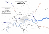
Ringway 1 or the London Motorway Box was the innermost of the series of four motorway standard roads, known as the London Ringways
London Ringways
The London Ringways were a series of four ring roads planned in the 1960s to circle London at various distances from the city centre. They were part of a comprehensive scheme developed by the Greater London Council to alleviate traffic congestion on the city's road system by providing high speed...
as part of a comprehensive scheme developed by the Greater London Council
Greater London Council
The Greater London Council was the top-tier local government administrative body for Greater London from 1965 to 1986. It replaced the earlier London County Council which had covered a much smaller area...
(GLC) to provide high speed motorway-standard roads within the capital linking a series of radial roads taking traffic into and out of the city. The scheme was cancelled in 1973.
History
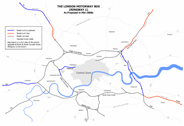
Ringway 1 was planned to comprise four sections across the capital forming a roughly rectangular box of motorways. These sections were designated:- North Cross RouteNorth Cross RouteNorth Cross Route was a planned motorway-standard road which would have formed the northern section of Ringway 1 and would have formed the innermost circuit of the London Ringways network. The six-lane dual carriageway with grade separated junctions to an extended M1 Motorway was planned during...
- from HarlesdenHarlesdenHarlesden is an area in the London Borough of Brent, northwest London, UK. Its main focal point is the Jubilee Clock which commemorates Queen Victoria's Golden Jubilee....
to Hackney WickHackney WickHackney Wick is an area straddling the boundary between the London Borough of Hackney and the London Borough of Tower Hamlets in east London. It is an inner-city development situated 5 miles northeast of Charing Cross...
via West HampsteadWest HampsteadWest Hampstead is an area in northwest London, England, situated between Childs Hill to the north, Frognal and Hampstead to the north-east, Swiss Cottage to the east, and South Hampstead to the south. Until the late 19th century, the locale was a small village called West End...
, Camden TownCamden Town-Economy:In recent years, entertainment-related businesses and a Holiday Inn have moved into the area. A number of retail and food chain outlets have replaced independent shops driven out by high rents and redevelopment. Restaurants have thrived, with the variety of culinary traditions found in...
, HighburyHighbury- Early Highbury :The area now known as Islington was part of the larger manor of Tolentone, which is mentioned in the Domesday Book. Tolentone was owned by Ranulf brother of Ilger and included all the areas north and east of Canonbury and Holloway Road. The manor house was situated by what is now...
and DalstonDalstonDalston is a district of north-east London, England, located in the London Borough of Hackney. It is situated northeast of Charing Cross. The area is identified in the London Plan as one of 35 major centres in Greater London... - East Cross RouteEast Cross RouteEast Cross Route is a dual-carriageway road constructed in east London as part of the uncompleted Ringway 1 as part of the London Ringways plan drawn up the 1960s to create a series of high speed roads circling and radiating out from central London...
- from Hackney Wick to KidbrookeKidbrookeKidbrooke is a district of South East London, England, located in the London Borough of Greenwich.The district takes its name from the Kyd Brook, a watercourse which runs from Orpington to Lewisham, by which point it is part of the River Quaggy...
via BowBow, LondonBow is an area of London, England, United Kingdom in the London Borough of Tower Hamlets. It is a built-up, mostly residential district located east of Charing Cross, and is a part of the East End.-Bridges at Bowe:...
, BlackwallBlackwall, LondonBlackwall is an area of the East End of London, situated in the London Borough of Tower Hamlets on the north bank of the River Thames.The district around Blackwall Stairs was known as Blackwall by at least the 14th century. This presumably derives from the colour of the river wall, constructed in...
and GreenwichGreenwichGreenwich is a district of south London, England, located in the London Borough of Greenwich.Greenwich is best known for its maritime history and for giving its name to the Greenwich Meridian and Greenwich Mean Time... - South Cross RouteSouth Cross RouteSouth Cross Route was the designation for the southern section of Ringway 1, the innermost circuit of the London Ringways network, a complex and comprehensive plan for a network of high speed roads circling and radiating out from central London designed to manage and control the flow of traffic...
- from Kidbrooke to BatterseaBatterseaBattersea is an area of the London Borough of Wandsworth, England. It is an inner-city district of South London, situated on the south side of the River Thames, 2.9 miles south-west of Charing Cross. Battersea spans from Fairfield in the west to Queenstown in the east...
via LewishamLewishamLewisham is a district in South London, England, located in the London Borough of Lewisham. It is situated south-east of Charing Cross. The area is identified in the London Plan as one of 35 major centres in Greater London.-History:...
, PeckhamPeckhamPeckham is a district in south London, England, located in the London Borough of Southwark. It is situated south-east of Charing Cross. The area is identified in the London Plan as one of 35 major centres in Greater London...
, BrixtonBrixtonBrixton is a district in the London Borough of Lambeth in south London, England. It is south south-east of Charing Cross. The area is identified in the London Plan as one of 35 major centres in Greater London....
and ClaphamClaphamClapham is a district in south London, England, within the London Borough of Lambeth.Clapham covers the postcodes of SW4 and parts of SW9, SW8 and SW12. Clapham Common is shared with the London Borough of Wandsworth, although Lambeth has responsibility for running the common as a whole. According... - West Cross RouteWest Cross RouteThe West Cross Route is a short, dual carriageway section of the A3220 route in central London in The Royal Borough of Kensington and Chelsea, with a small part being shared with borderlining borough Hammersmith and Fulham. It runs north-south between the northern elevated roundabout junction...
- from Harlesden to Battersea via North KensingtonNorth KensingtonNorth Kensington is an area of west London lying north of Notting Hill Gate and south of Harrow Road.North Kensington is the key neighbourhood of Notting Hill...
, Shepherds Bush, West KensingtonWest Kensington, London- Commercial/education :Local business consists of small shops, offices and restaurants, with the Olympia Exhibition Centre nearby. Indeed, it is the mix of local shops that give the area its character....
, Earls CourtEarls CourtEarls Court is a district in the Royal Borough of Kensington and Chelsea in London, England. It is an inner-city district centred on Earl's Court Road and surrounding streets, located 3.1 miles west south-west of Charing Cross. It borders the sub-districts of South Kensington to the East, West...
and Chelsea HarbourChelsea HarbourChelsea Harbour is a mixed-use development in Central London, situated on the north bank of the River Thames, in the Sands End area. It lies within the eastern boundary of the London Borough of Hammersmith and Fulham and on the southwestern boundary of the Royal Borough of Kensington and...
Much of the scheme would have been constructed as elevated roads on concrete pylons and the routes were designed to follow the alignments of existing railway lines to minimise the amount of land required for construction. Nevertheless the disruption and widespread demolition required to build the Ringway would have been considerable; in 1970 the GLC set aside £1.7 billion (approximately £ today) for the construction of about half of the Ringways. Of this sum Ringway 1 was expected to cost £480 million (£ today) including £144 million (£ today) for property purchases. It would require 1048 acres (4.2 km²) and affect 7,585 houses.
The only parts of Ringway 1 that were constructed were part of the West Cross Route between North Kensington and Shepherds Bush which was opened by Michael Heseltine
Michael Heseltine
Michael Ray Dibdin Heseltine, Baron Heseltine, CH, PC is a British businessman, Conservative politician and patron of the Tory Reform Group. He was a Member of Parliament from 1966 to 2001 and was a prominent figure in the governments of Margaret Thatcher and John Major...
in 1970, simultaneously with Westway
Westway (London)
The Westway is a long elevated dual carriageway section of the A40 route in west London running from Paddington to North Kensington. The road was constructed between 1964 and 1970 to relieve congestion at Shepherd's Bush caused by traffic from Western Avenue struggling to enter central London on...
, to loud protests; some residents hung a huge banners with 'Get us out of this Hell- Rehouse Us Now' outside their windows and protesters disrupted the opening procession by driving a lorry the wrong way along the new road. The East Cross Route, including a new 'eastern bore' for the Blackwall Tunnel
Blackwall Tunnel
The Blackwall Tunnel is a pair of road tunnels underneath the River Thames in east London, linking the London Borough of Tower Hamlets with the London Borough of Greenwich, and part of the A102 road. The northern portal lies just south of the East India Dock Road in Blackwall; the southern...
opened between 1967 and 1979.
See also
Other London Ringways- Ringway 2Ringway 2Ringway 2 was the second innermost of the series of four London Ringways, ring roads planned in the 1960s to circle London at various distances from the city centre...
- Ringway 3Ringway 3Ringway 3 was the third from the centre of the series of four London Ringways, ring roads planned in the 1960s to circle London at various distances from the city centre...
- Ringway 4Ringway 4Ringway 4 was the outermost of the series of four London Ringways, ring roads planned in the 1960s to circle London at various distances from the city centre...
- Homes before RoadsHomes before RoadsHomes before Roads was a 1970s political movement and campaign in the United Kingdom initially formed in London in 1970 to oppose plans to construct a system of four interlinked concentric motorways through and around London, known as Ringways...