

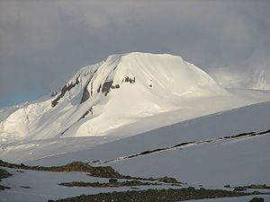
Rezen Knoll
Encyclopedia
South Shetland Islands
The South Shetland Islands are a group of Antarctic islands, lying about north of the Antarctic Peninsula, with a total area of . By the Antarctic Treaty of 1959, the Islands' sovereignty is neither recognized nor disputed by the signatories and they are free for use by any signatory for...
, Antarctica. The knoll is bounded to the east, north and west by Perunika Glacier
Perunika Glacier
Perunika Glacier is an 8 km long and 3 km wide roughly crescent-shaped glacier in eastern Livingston Island in the South Shetland Islands, Antarctica....
, and linked to Burdick Ridge
Burdick Ridge
Burdick Ridge is a ridge rising to 773 m on Livingston Island in the South Shetland Islands. Extending for 1.9 km between Orpheus Gate in the southeast and Rezen Saddle in the northwest. Bounded by Perunika Glacier to the northeast, and Balkan Snowfield to the southwest. Takes its name from...
by Rezen Saddle
Rezen Saddle
Rezen Saddle is a geographical feature on Livingston Island in the South Shetland Islands, Antarctica. The 600 m long horseshoe-shaped flat saddle of elevation 420 m lies between Rezen Knoll and Burdick Ridge in eastern Livingston Island, affording overland access from Balkan Snowfield to upper...
. The feature is 250 m wide, extending 500 m in east-west direction. Composed of lavas, with precipitous slopes except to the east. Partly ice-free height and western and northern slopes.
First ascent by the Bulgarians Kuzman Tuhchiev, Dimo Dimov and Ivan Tashukov from St. Kliment Ohridski Base
St. Kliment Ohridski Base
St. Kliment Ohridski Base is a Bulgarian Antarctic base on Livingston Island in the South Shetland Islands.The base, originally known as Sofia University Refuge, was named in 1993 "for St...
during the 1994/95 season.
Rough British mapping in 1968, detailed mapping by the Spanish Servicio Geográfico del Ejército in 1991. Co-ordinates, elevation and distances given according to a 1995-96 Bulgarian topographic survey.
A descriptive name of national geography. Golyam (Big) Rezen
Golyam Rezen
Golyam Rezen is a peak on Vitosha Mountain in Bulgaria. Rising to 2,277 m, the peak is second to the mountain's summit Cherni Vrah situated 900 m to the west. Golyam Rezen hosts an Air Traffic Services facility, as well as military communications installations...
and Malak (Little) Rezen
Malak Rezen
Malak Rezen is a peak rising to 2,191 m in northeastern Vitosha Mountain in Bulgaria. The peak is situated 1.5 km northeast of the summit Cherni Vrah, and 1.3 km north by east of Golyam Rezen Peak, surmounting Stenata ski run and Aleko site to the north.Malak Rezen is accessible...
are two of the most spectacular peaks of Vitosha Mountain
Vitosha
Vitosha is a mountain massif, on the outskirts of Sofia, the capital of Bulgaria. Vitosha is one of the tourists symbols of Sofia and the closest site for hiking, alpinism and skiing. Convenient bus lines and rope ways render the mountain easily accessible. Vitosha has the outlines of an enormous...
near Sofia
Sofia
Sofia is the capital and largest city of Bulgaria and the 12th largest city in the European Union with a population of 1.27 million people. It is located in western Bulgaria, at the foot of Mount Vitosha and approximately at the centre of the Balkan Peninsula.Prehistoric settlements were excavated...
, Bulgaria
Bulgaria
Bulgaria , officially the Republic of Bulgaria , is a parliamentary democracy within a unitary constitutional republic in Southeast Europe. The country borders Romania to the north, Serbia and Macedonia to the west, Greece and Turkey to the south, as well as the Black Sea to the east...
. ‘Rezen’ is the Bulgarian for ‘slice.’
Location
The hill is located at 62°37′31"S 60°16′37"W which is 3.94 km west by south of Mount BowlesMount Bowles
Mount Bowles is an ice-covered mountain of elevation 822 m, the summit of Bowles Ridge in eastern Livingston Island, South Shetland Islands. Situated 3 mi north of Mount Friesland to which it is linked by Wörner Gap. Coordinates and elevation given according to 2003 Australian GPS survey...
, 3.07 km east-southeast of Aleko Point
Aleko Point
Aleko Point , also Aleko Rock, is a rocky point midway along the northeast Antarctic coast of Emona Anchorage in the east of Livingston Island, projecting 150m to the west of southwest....
, 4.65 km east-northeast of Sinemorets Hill
Sinemorets Hill
Sinemorets Hill is the second most prominent in the chain of hills surmounting Bulgarian Beach in eastern Livingston Island in the South Shetland Islands, Antarctica....
, 1.56 km northwest of Burdick Peak
Burdick Peak
Burdick Peak rises southwest of Mount Bowles on Livingston Island, in the South Shetland Islands. It was named by the UK Antarctic Place-names Committee in 1958 for Christopher Burdick, Master of the American schooner Huntress of Nantucket, who visited the South Shetland Islands in 1820–21....
, and 630 m north-northwest of Burdick West Peak
Burdick West Peak
Burdick West Peak rises to 455 m at the northwest extremity of Burdick Ridge in eastern Livingston Island...
.
Maps
- Isla Livingston: Península Hurd. Mapa topográfico de escala 1:25 000. Madrid: Servicio Geográfico del Ejército, 1991.
- L.L. Ivanov. Livingston Island: Central-Eastern Region. Scale 1:25000 topographic map. Sofia: Antarctic Place-names Commission of Bulgaria, 1996.
- L.L. Ivanov et al. Antarctica: Livingston Island and Greenwich Island, South Shetland Islands. Scale 1:100000 topographic map. Sofia: Antarctic Place-names Commission of Bulgaria, 2005.
- L.L. Ivanov. Antarctica: Livingston Island and Greenwich, Robert, Snow and Smith Islands. Scale 1:120000 topographic map. Troyan: Manfred Wörner Foundation, 2009. ISBN 978-954-92032-6-4