

Regrading in Seattle
Encyclopedia
Seattle, Washington
Seattle is the county seat of King County, Washington. With 608,660 residents as of the 2010 Census, Seattle is the largest city in the Northwestern United States. The Seattle metropolitan area of about 3.4 million inhabitants is the 15th largest metropolitan area in the country...
was radically altered by a series of regrades
Regrading
Regrading is the process of raising and/or lowering the levels of land; such a project can also be referred to as a regrade. Regrading may be done on a small scale or on quite a large scale...
in the city's 1st century of urban settlement, in what might have been the largest such alteration of urban terrain at the time.
The heart of Seattle (a city in the state of Washington, USA) lies on an isthmus
Isthmus
An isthmus is a narrow strip of land connecting two larger land areas usually with waterforms on either side.Canals are often built through isthmuses where they may be particularly advantageous to create a shortcut for marine transportation...
between the city's chief harbor—the saltwater Elliott Bay
Elliott Bay
Elliott Bay is the body of water on which Seattle, Washington, is located. A line drawn from Alki Point in the south to West Point in the north serves to mark the generally accepted division between the bay and the open sound...
(an inlet of Puget Sound
Puget Sound
Puget Sound is a sound in the U.S. state of Washington. It is a complex estuarine system of interconnected marine waterways and basins, with one major and one minor connection to the Strait of Juan de Fuca and the Pacific Ocean — Admiralty Inlet being the major connection and...
)—and the fresh water of Lake Washington
Lake Washington
Lake Washington is a large freshwater lake adjacent to the city of Seattle. It is the largest lake in King County and the second largest in the state of Washington, after Lake Chelan. It is bordered by the cities of Seattle on the west, Bellevue and Kirkland on the east, Renton on the south and...
. Capitol Hill
Capitol Hill, Seattle, Washington
Capitol Hill is the most densely populated residential district in Seattle, Washington, United States. It is the center of the city's gay and counterculture communities, and is one of the city's most prominent nightlife and entertainment districts....
, First Hill
First Hill, Seattle, Washington
First Hill is a neighborhood in Seattle, Washington, named for the hill on which it is located. The hill, in turn, is so named for being the first hill one encounters traveling east from downtown Seattle toward Lake Washington....
, and Beacon Hill
Beacon Hill, Seattle, Washington
Beacon Hill is a hill and neighborhood in southeast Seattle, Washington. The municipal government subdivides it into North Beacon Hill, Mid-Beacon Hill, Holly Park, and South Beacon Hill, though most people who live there simply call it "Beacon Hill." Home to the world headquarters of Amazon.com...
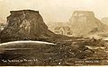
collectively constitute a ridge along this isthmus. In addition, at the time the city was founded, the steep Denny Hill stood in the area now known as Belltown
Belltown, Seattle, Washington
Belltown is a neighborhood in Seattle, Washington, United States, in the 98121 Zip Code, located on the city's downtown waterfront, on land that was artificially flattened as part of a regrading project...
or the Denny Regrade
Denny Regrade, Seattle, Washington
The Denny Regrade is a neighborhood in Seattle, Washington, USA, that stretches north of the central business district to the grounds of Seattle Center. Its generally flat terrain was originally a steep hill, taken down as part of a mammoth construction project in the first decades of the 20th...
.
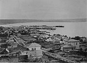
When white settlers first came to Seattle in the early 1850s, the tides of Elliott Bay lapped at the base of Beacon Hill. The original location of the settlement that became Seattle—today's Pioneer Square
Pioneer Square, Seattle, Washington
Pioneer Square is a neighborhood in the southwest corner of Downtown Seattle, Washington, USA. It was once the heart of the city: Seattle's founders settled there in 1852, following a brief six-month settlement at Alki Point on the far side of Elliott Bay. The early structures in the neighborhood...
—was a low-lying island. A series of regrades leveled paths for roads, demolished Denny Hill, and turned much of Jackson Hill (a remnant of which remains along Main Street in the International District
International District, Seattle, Washington
The Chinatown-International District of Seattle, Washington is an ethnic enclave neighborhood and is the center of Seattle's Asian American community. The neighborhood is multiethnic, consisting mainly of people who are of Chinese, Japanese, and Filipino ethnicity...
) into a near-canyon between First and Beacon Hills. The roughly 50000000 short tons (45,359,237 MT) of earth from these 60 regrades provided landfill
Land reclamation
Land reclamation, usually known as reclamation, is the process to create new land from sea or riverbeds. The land reclaimed is known as reclamation ground or landfill.- Habitation :...
for the city's waterfront and the industrial/commercial neighborhood now known as SoDo
SoDo, Seattle, Washington
SoDo is a neighborhood in Seattle, Washington, that makes up part of the city's Industrial District. It is bounded on the north by South King Street, beyond which is Pioneer Square; on the south by South Spokane Street, beyond which is more of the Industrial District; on the west by the Duwamish...
, and built Harbor Island, at the time the largest man-made island in the world.
The early years
These informal regrades came to an end around 1900; later regrades typically required changes to areas that had already undergone some development. City engineer R.H. Thomson
Reginald H. Thomson
Reginald Heber Thomson was a self-taught American civil engineer. He worked in Washington state, mainly in Seattle, where he became city engineer in 1892 and held the position for two decades. Alan J...
established his prestige in 1900. He successfully provided the city with ample fresh water by running a pipeline from the Cedar River
Cedar River (Washington)
The Cedar River is a river in the U.S. state of Washington. About long, it originates in the Cascade Range and flows generally west and northwest, emptying into the southern end of Lake Washington...
. He then undertook to level the extreme hills that rose south and north of the bustling city center.
Cutting through Beacon Hill
Eugene Semple
Eugene Semple was the thirteenth Governor of Washington Territory and the unsuccessful Democratic candidate to be the first governor of Washington State.-Early life:...
(1840–1908) proposed several ambitious plans to reengineer Seattle. One of these, which he undertook in 1901, was to dig a canal from Elliott Bay to Lake Washington by cutting through Beacon Hill in roughly the area of Spokane Street, sluicing earth into the tide flats. His effort was defeated by unstable soils, which caused several cave-ins, and by the legal and political maneuvering of Judge Thomas Burke
Thomas Burke (judge)
Thomas Burke was an American lawyer, railroad builder, and judge who made his career in Seattle, Washington. He served as Chief Justice of the Supreme Court of the Washington Territory from 1888 to 1889. He was the main representative of railroad magnate James J. Hill in Seattle...
and others aligned with the Great Northern Railway. The Lake Washington Ship Canal
Lake Washington Ship Canal
The Lake Washington Ship Canal, which runs through the City of Seattle, Washington, connects the fresh water body of Lake Washington with the salt water inland sea of Puget Sound. The Ship Canal includes a series of locks, modeled after the Panama Canal, to accommodate the different water levels...
ultimately followed the route north of downtown favored by Burke, utilizing existing lakes and bays. Semple left behind a canyon that is now used by the Spokane Street interchange on Interstate 5
Interstate 5
Interstate 5 is the main Interstate Highway on the West Coast of the United States, running largely parallel to the Pacific Ocean coastline from Canada to Mexico . It serves some of the largest cities on the U.S...
.
Thomson resumed the work of cutting through Beacon Hill to connect central Seattle to the Rainier Valley
Rainier Valley, Seattle, Washington
The Rainier Valley neighborhood in Seattle, is located east of Beacon Hill; west of Mount Baker, Seward Park, and Leschi; south of the Central District and First Hill; and north of the city line...
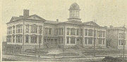
, the first of his major regrades, but he made his cut farther north. The Jackson Regrade between 1907 and 1910 slashed 85 feet (25.9 m) from the hill, requiring the demolition of the public South School and the original Holy Names Academy
Holy Names Academy
Holy Names Academy is a Catholic private all-girls college-preparatory high school located on the east slope of Seattle's Capitol Hill at 21st Avenue East between E. Aloha and E. Roy Streets. Located in the Roman Catholic Archdiocese of Seattle, the school has been named a Blue Ribbon School by...
but providing fill for the tide flats below Beacon Hill that stretched south from King Street, filling in today's SoDo. Jackson Street became a slow slope upward from Elliott Bay in the west to the Central District
Central District, Seattle, Washington
The Central District is a mostly residential district in Seattle located east of Cherry Hill, west of Madrona and Leschi, south of Capitol Hill, and north of Rainier Valley...
east of the Capitol Hill – First Hill – Beacon Hill ridge.
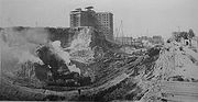
Shortly afterward, just south of the Jackson Regrade, the Dearborn Street Regrade made an even deeper cut through the ridge. In one place, the level of the land was lowered by 108 feet (32.9 m); 1600000 cubic yards (1,223,288 m³) of earth were moved. As with Semple's abandoned canal, there were several landslides, and many homes were destroyed that were not originally planned to be removed.
The resulting gap at Dearborn Street was deep enough to require a bridge running roughly north-south. Originally known as the 12th Avenue South Bridge
12th Avenue South Bridge
The Jose Rizal Bridge carries 12th Avenue South across South Dearborn Street and Interstate 90 in Seattle, connecting the International District to Beacon Hill. Built in 1911, and originally called the 12th Avenue South Bridge or the Dearborn Street Bridge, it was one of the first permanent steel...
and now known as the Jose P. Rizal Bridge, it is now on the National Register of Historic Places
National Register of Historic Places
The National Register of Historic Places is the United States government's official list of districts, sites, buildings, structures, and objects deemed worthy of preservation...
.
The Denny Regrade
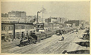
Although in retrospect it is referred to as the Denny Regrade (and the name has become the name of a neighborhood), there were, in fact, several separate regrades of the former Denny Hill, beginning with private-sector efforts. Around 1900, property owners along relatively low-lying First Avenue took it upon themselves to cut through from Pike Street to Cedar Street. A similar cut (but initiated by the City) lowered Second Avenue in 1904; around the same time, the south part of the hill was shaved off as Pike and Pine Streets were regraded between Second and Fifth Avenues.
The more dramatic Denny Regrade No. 1 (1908–1911) sluiced away the entire half of the hill closest to the waterfront, about 27 city blocks extending from Pine Street to Cedar Street and from Second to Fifth Avenues. 20000000 gallons (75,708 kl) of water a day were pumped from Lake Union
Lake Union
Lake Union is a freshwater lake entirely within the Seattle, Washington city limits.-Origins:A glacial lake, its basin was dug 12,000 years ago by the Vashon glacier, which also created Lake Washington and Seattle's Green, Bitter, and Haller Lakes.-Name:...
, to be aimed at the hill as jets of water, then run through tunnels to Elliott Bay.
Much of the motivation for the regrade had been to increase land values, but the area opened up—the heart of today's Belltown—was left as a strip cut off from much of the rest of the city by the remaining eastern half of the hill, whose western face offered no route of approach. Meanwhile, property-owners and investors hesitated to build on the remaining portion of the hill, because they considered it likely that their buildings would eventually be destroyed in the next phase of the regrading process, which was now well under way.
The result was Denny Regrade No. 2, begun in February 1929 and lasting 22 months. This time, the technology was power shovels rather than sluicing, with earth carried to the waterfront by conveyor belt
Conveyor belt
A conveyor belt consists of two or more pulleys, with a continuous loop of material - the conveyor belt - that rotates about them. One or both of the pulleys are powered, moving the belt and the material on the belt forward. The powered pulley is called the drive pulley while the unpowered pulley...
s, then placed on specially designed scow
Scow
A scow, in the original sense, is a flat-bottomed boat with a blunt bow, often used to haul bulk freight; cf. barge. The etymology of the word is from the Dutch schouwe, meaning such a boat.-Sailing scows:...
s and dumped in deep water. The scows were intentionally designed to capsize in a controlled manner. They were symmetrical top-to-bottom and side to side; a seacock
Seacock
A seacock is a valve on the hull of a boat, permitting water to flow into the boat, such as for cooling an engine or for a salt water faucet; or out of the boat, such as for a sink drain or a toilet....
could be opened to fill one side with water. In three minutes it would capsize, dump its load, bob up, empty the tank, and right itself.
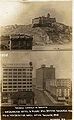
One of the buildings demolished in Denny Regrade No. 2 was the Denny School on Battery Street between 5th and 6th Avenues. Opened in 1884, it had been described as "an architectural jewel… the finest schoolhouse on the West Coast."
While the 38 blocks were being regraded, the country entered the Great Depression
Great Depression
The Great Depression was a severe worldwide economic depression in the decade preceding World War II. The timing of the Great Depression varied across nations, but in most countries it started in about 1929 and lasted until the late 1930s or early 1940s...
, radically reducing the demand for land. Most of the new lots sat vacant into the 1940s; the area (especially east of Sixth Avenue) remained a "gray zone" into the early 21st century, when it finally began to gain a urban or suburban identity as the west edge of the new growth of South Lake Union
South Lake Union, Seattle, Washington
South Lake Union is a neighborhood in Seattle, Washington, so named because it is at the south tip of Lake Union.The official boundaries of the City of Seattle Urban Center are Denny Way on the south, beyond which is Denny Triangle; Interstate 5 on the east, beyond which is Capitol Hill; Aurora...
.
Further reading
- Emerald City: an environmental history of Seattle, Klingle, Matthew W., Yale University Press, 2007, ISBN 9780300116410.