

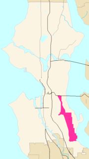
Rainier Valley, Seattle, Washington
Encyclopedia
Beacon Hill, Seattle, Washington
Beacon Hill is a hill and neighborhood in southeast Seattle, Washington. The municipal government subdivides it into North Beacon Hill, Mid-Beacon Hill, Holly Park, and South Beacon Hill, though most people who live there simply call it "Beacon Hill." Home to the world headquarters of Amazon.com...
; west of Mount Baker
Mount Baker, Seattle, Washington
Mount Baker is a neighborhood in southeast Seattle. The neighborhood's name comes from the view of Mount Baker in Whatcom County, that is seen by looking north over Lake Washington. It is bounded by Lake Washington to the east, Interstate 90 and then Leschi to the north, Rainier Valley to the west,...
, Seward Park
Seward Park, Seattle, Washington
Seward Park is a neighborhood in southeast Seattle, Washington just west of the park of the same name. The park itself occupies all of Bailey Peninsula, a prominent, forested peninsula that juts into Lake Washington...
, and Leschi
Leschi, Seattle, Washington
Leschi is a neighborhood located within the city of Seattle, Washington, USA. The neighborhood is named after Chief Leschi of the Nisqually tribe.- Location :...
; south of the Central District
Central District, Seattle, Washington
The Central District is a mostly residential district in Seattle located east of Cherry Hill, west of Madrona and Leschi, south of Capitol Hill, and north of Rainier Valley...
and First Hill
First Hill, Seattle, Washington
First Hill is a neighborhood in Seattle, Washington, named for the hill on which it is located. The hill, in turn, is so named for being the first hill one encounters traveling east from downtown Seattle toward Lake Washington....
; and north of the city line. It is said to be the most culturally and economically diverse neighborhood in the Pacific Northwest
Pacific Northwest
The Pacific Northwest is a region in northwestern North America, bounded by the Pacific Ocean to the west and, loosely, by the Rocky Mountains on the east. Definitions of the region vary and there is no commonly agreed upon boundary, even among Pacific Northwesterners. A common concept of the...
http://www.aolnews.com/opinion/article/opinion-americas-most-diverse-zip-code-shows-the-way/19414386.
The neighborhood's population is 40,791, with Asians making up the largest group (with Filipinos the largest within the Asian population of the Valley). However, there remains a large African American population, as well as those Americans of European descent. Its zip code is 98118, which also includes the neighboohood directly east of Rainier Valley of Seward Park. Beacon Hill to the east is largely 98108. Rainier Valley's racial breakdown as follows: 26.9% Caucasian, 26% African American, 34.1% Asian, 1% Native American, 1.6% Pacific Islander, 6.5% Mixed Race, and 3.4% from other races. Hispanic or Latino of any race were 7.2% of the population. 11.1% of families and 13.9% of the population were below poverty line. http://factfinder.census.gov/servlet/SAFFFacts?_event=ChangeGeoContext&geo_id=86000US98118&_geoContext=01000US%7C04000US53%7C05000US53033&_street=&_county=&_cityTown=&_state=04000US53&_zip=98118&_lang=en&_sse=on&ActiveGeoDiv=geoSelect&_useEV=&pctxt=fph&pgsl=010&_submenuId=factsheet_1&ds_name=DEC_2000_SAFF&_ci_nbr=null&qr_name=null®=null%3Anull&_keyword=&_industry=
There are several identifiable neighborhoods within the Rainier Valley, including (from north to south) "Garlic Gulch" (or the north Valley, from Dearborn to the junction of MLK and Rainier) "Genesee" (from the junction to Alaska Street) Columbia City
Columbia City, Seattle, Washington
Columbia City is a neighborhood in the Rainier Valley area of southeast Seattle, Washington, known either for being one of the "hottest" neighborhoods in Seattle, or for its rapid gentrification, depending on one's perspective...
, Hillman City (from Lucille Street to Graham Street), "Brighton" (Graham to Othello) Dunlap
Dunlap, Seattle, Washington
Dunlap is a neighborhood in south Seattle, Washington, just west of Rainier Beach. It is home to Dunlap Elementary School, part of the Seattle Public Schools. Dunlap is named after Joseph Dunlap, the first homesteader in the area....
(also known as Othello)(Othello to Cloverdale), and Rainier Beach
Rainier Beach, Seattle, Washington
Rainier Beach is a set of neighborhoods in Seattle, Washington that are mostly residential. Also called Atlantic City, Rainier Beach can include Dunlap, Pritchard Island, and Rainier View neighborhoods....
.
The Valley is centered on Rainier Avenue S. and Martin Luther King Jr. Way S., its main (northwest- and southeast-bound) thoroughfares. Both the Rainier Avenue and the Valley were named after Mount Rainier
Mount Rainier
Mount Rainier is a massive stratovolcano located southeast of Seattle in the state of Washington, United States. It is the most topographically prominent mountain in the contiguous United States and the Cascade Volcanic Arc, with a summit elevation of . Mt. Rainier is considered one of the most...
, towards which "[t]hrough a fortunate geographic circumstance" the Valley (and hence the avenue) is oriented. Rainier Avenue goes through several distinct phases, with the north-end being mainly commercial, the central (Columbia City) portion a densely-populated historic district, and the southern portion a less dense collection of businesses, apartments, and houses.
Martin Luther King Jr. Way South (sometimes affectionately shortened to Milky Way), formerly known as Empire Way (renamed in the 1970s), now houses Seattle light railroad for its entire length of the Valley until it enters the wealthy enclave of Mt Baker (included in Rainer Valley by the city of Seattle, but not by most South Enders - see http://clerk.ci.seattle.wa.us/~public/nmaps/html/NN-1300S.htm). Light rail, and its attendant improvements (most notably underground wiring), has breathed new life into Martin Luther King Jr Way South, arguably one of the most blighted thoroughfares in Seattle for decades. New businesses are sprouting along the Milky Way, though unfortunately, the Way is underserved by rail stops, of which there are only four (McClelland at the start of the north valley, Columbia City at the north end of the Central valley, and Henderson and Othello in the South Valley). This unfortunate circumstance arise from Valley politics of the late-1980s/early 1990s, when the light rail was planned, when Seward Park residents ensured there were no stops in the center of the Central Valley, by either Orcas or Graham Streets, despite these being the home of a natural stop (between the two streets), so that they would not be inconvencienced by a stop as they made their way to I-5 on these two access roads. As a result, there are no light rail stops on Martin Luther King Jr Way South from Othello Street to Alaska Street, a two mile-long stretch, an absurd length for an urban transit system that is supposed to provide access for the Valley (which many Seattleites will refer to as "inner city" despite its lower density than almost any other part of residential Seattle except dowuntown) to downtown and the airport. As a result this two mile portion of the "Way" is more depressed than it should be, and between Orcas and Graham (approximately 1/2 mile) remains seriously blighted; in this half-mile stretch, where a station naturally belongs (approximately one mile north of the Othello stop and one mile south of the Columbia city stop), there is none.
Rainier Valley is known for a roughly 1/4 split between whites, blacks, Asians, and Hispanics (though the statistics noted above are a little different) and for the relative harmony between these groups. Italians were prominent in the early 1900s and some could argue set the harmonious tone of the Valley that survives to this day. Unfortunately, most of the Italians, with some notable exceptions, left the Valley in the 1960s. However, while Italians were prominent in the north Valley in the early 20th century, the Central Valley (Columbia City and therabouts) was mostly settled by the same midwestern folk and northern-European immigrants (primarily British and Scandinavian) who settled most of the rest of Seattle. Notwithstanding these generalizations, there have always been Asians in the Valley, with Japanese famers living in the Valley (attracted by the same raason the Italians were, for the rich Valley bottomland) since its inception - there were two historic Japanese-American nurseries in the Valley - Mizukis and Holly Park, with Holly Park Nursery a vibrant presence to this day. It is tough to describe the Valley, but it can be said that the construction of the The Holly Park and Rainier Vista housing projects World War II to house war workers were seminal events. Following the war and until the Boeing crash of 1971, the Valley boomed with middle-class residential construction (lots of post-war split-levels dot the valley) and with all of this construction, the Valley contineed its historic diversity. Interracial couples in the 1950s found the Valley more accepting than the northern half of the city because of the relative lack of "deed covenants" found in the South End (these covenants were ruled unconstitutional by the US Supreme Court in the 1960s).
Ironically, the Civil Rights Act precipitated a "white flight" from the Valley despite its historic diversity. The general exodus of whites from the Valley, Beacon Hill, and Seward Park, which begin in the mid-60s, was primarily over by the mid-80s, when some historic "children of the Valley" began to return to it, as well as other non-immigrant adventurous sorts attracted to its affordable housing, its excellent access to parks, downtown, and the entire metropolitan area. With the end of the Vietnam War
Vietnam War
The Vietnam War was a Cold War-era military conflict that occurred in Vietnam, Laos, and Cambodia from 1 November 1955 to the fall of Saigon on 30 April 1975. This war followed the First Indochina War and was fought between North Vietnam, supported by its communist allies, and the government of...
in 1975, a wave of Vietnamese immigrants opened businesses along abandoned areas of Martin Luther King Jr. Way South, extending four miles south of the official Little Saigon neighborhood on South Jackson Street. Perhaps more numerous than this Vietnamese wave was that of Filipinos throughout the Valley, though their businesses are fewer. St. Edward Roman Catholic Church is the cultural heart of the Filipino community in the Valley, and St. Edward School remains a beacon in the Central Valley for those Valley parents wishing a Christian education for their children, of whome Filipinos are currently the majority.
Many residents cite ethnic diversity, parks and transportation options as some of the main reasons they remain in or move to the Valley, and it has been called the most diverse neighborhood in the United States, although this may not be strictly true. Gentrification, including rising land prices and a light rail line being built, may put a damper on diversity in the future, but this remains to be seen.
Beginning in the 1960s, Rainier Valley began to be viewed as "unsafe," with this view peaking in the 1980s. As noted, the Valley is diverse, and did include two housing projects, Rainir Vista, and Holly Park that have been completely remodeled and with regard to Holly Park, actually renamed (New Holly) because the associations became so grim. However, the dangerous aspect of the Valley has always been overstated by those who do not live there, and while it may be verifiable that the Valley is the home or such organized gangs as the 74 Hoover Crips
Crips
The Crips are a primarily, but not exclusively, African American gang. They were founded in Los Angeles, California, in 1969 mainly by Raymond Washington and Stanley Williams...
which have had a rivalry against the Central District
Central District, Seattle, Washington
The Central District is a mostly residential district in Seattle located east of Cherry Hill, west of Madrona and Leschi, south of Capitol Hill, and north of Rainier Valley...
Bloods
Bloods
The Bloods are a street gang founded in Los Angeles, California. The gang is widely known for its rivalry with the Crips. They are identified by the red color worn by their members and by particular gang symbols, including distinctive hand signs...
http://www.seattlepi.com/local/272039_gangs30.html, Columbia City has an active nightlife, and security-requirements can be as low or lower than other parts of Seattle (one resident near Columbia City has had no security for 23 years). Of the 28 homicides in Seattle in 2008, 6 occurred in Rainier Valley, which may have some statistical disproportianlity (21% of homicides vs. 8% of the population) to it, but by no means should it suggest that the Valley, with all its interesting restaurants and shops, should be avoided, since Seattle is such a safe city to begin with. http://blog.seattlepi.com/seattle911/archives/158310.asp
The Valley neighborhoods bordering Rainier Avenue rival any other part of Seattle for age, since they are near the historic streetcar (removed in 1937) that connected downdown Seattle first to Columbia City and then to Renton. In 1892 rails were laid to Columbia City and later (but very early in the 20th century) to Renton (the steetcar was known as the "Rainier Valley and Renton Railroad"). The railroad, the reorientation of the Duwamish River
Duwamish River
The Duwamish River is the name of the lower of Washington state's Green River. Its industrialized estuary is known as the Duwamish Waterway.- History :...
and the lowering of Lake Washington
Lake Washington
Lake Washington is a large freshwater lake adjacent to the city of Seattle. It is the largest lake in King County and the second largest in the state of Washington, after Lake Chelan. It is bordered by the cities of Seattle on the west, Bellevue and Kirkland on the east, Renton on the south and...
, which caused the lake to drain west through Lake Union
Lake Union
Lake Union is a freshwater lake entirely within the Seattle, Washington city limits.-Origins:A glacial lake, its basin was dug 12,000 years ago by the Vashon glacier, which also created Lake Washington and Seattle's Green, Bitter, and Haller Lakes.-Name:...
and the Ship Canal
Lake Washington Ship Canal
The Lake Washington Ship Canal, which runs through the City of Seattle, Washington, connects the fresh water body of Lake Washington with the salt water inland sea of Puget Sound. The Ship Canal includes a series of locks, modeled after the Panama Canal, to accommodate the different water levels...
rather than south, made the valley dry enough to allow building, where it boomed along with the rest of Seattle on and after the Alaskan Gold rush right up to the Depresseion of the 1930s. Because Seattle was a hamlet before the 1889 Alaskan Gold Rush, there is little to distinguish the historic parts of Rainier Valley from the rest of historic neighborhoods in Seattle. Away from Rainier Avenue, a fair amount of the development is postwar, when the Valley was filled out as part of the "Boeing boom," but historic pre-WW II housing can be found in every part of the Valley, where these often imposing homes once commanded large spreads that were later subdivided and sold off. Unlike most of Seattle, then, the Valley has an interesting mix of pre-and post-war houses cheek-to-jowl (in Seattle residential style), with only the neighborhood immediately surrounding Columbia City almost exclusively pre-WW II.