
Regional District of Okanagan-Similkameen, British Columbia
Encyclopedia
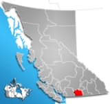
The Regional District of Okanagan-Similkameen (RDOS) is a regional district in southern British Columbia
, adjacent to the U.S. state of Washington. It is bounded by Fraser Valley Regional District
to the west, Thompson-Nicola Regional District and Regional District of Central Okanagan to the north, Regional District of Kootenay Boundary
to the east, and by Okanogan County, Washington to the south. As of the 2006 census
the population was 79,475. The district covers a land area of 10,413.44 km² (4,020.65 sq mi). The administrative offices are in the city
of Penticton. Other important population centres include the district municipality
of Summerland
, the town
s of Oliver
, Osoyoos
, and Princeton
, and the village
of Keremeos
.
. Pop. 1,921.
from Cawston
downstream to Chopaka
, at the US border. Pop. 1,082.
(though there are no residents there). Pop. 3,899.
and Okanagan Falls
. Pop. 5,913.
. Pop. 2,010.
. Pop. 2,308.
and Coalmont
. Pop. 2,208.
British Columbia
British Columbia is the westernmost of Canada's provinces and is known for its natural beauty, as reflected in its Latin motto, Splendor sine occasu . Its name was chosen by Queen Victoria in 1858...
, adjacent to the U.S. state of Washington. It is bounded by Fraser Valley Regional District
Fraser Valley Regional District
The Fraser Valley Regional District is a regional district in British Columbia, Canada. The FVRD covers an area of 13,361.74 km²...
to the west, Thompson-Nicola Regional District and Regional District of Central Okanagan to the north, Regional District of Kootenay Boundary
Regional District of Kootenay Boundary
The Regional District of Kootenay Boundary is a regional district in the province of British Columbia, Canada. As of the 2006 census, the population was 30,742. The area is 8,095.62 km² . The regional district's offices are in the city of Trail...
to the east, and by Okanogan County, Washington to the south. As of the 2006 census
Canada 2006 Census
The Canada 2006 Census was a detailed enumeration of the Canadian population. Census day was May 16, 2006. The next census following will be the 2011 Census. Canada's total population enumerated by the 2006 census was 31,612,897...
the population was 79,475. The district covers a land area of 10,413.44 km² (4,020.65 sq mi). The administrative offices are in the city
City
A city is a relatively large and permanent settlement. Although there is no agreement on how a city is distinguished from a town within general English language meanings, many cities have a particular administrative, legal, or historical status based on local law.For example, in the U.S...
of Penticton. Other important population centres include the district municipality
District municipality
A district municipality is a designation for a class of municipalities found in several locations, including Canada, Lithuania, and South Africa.-Usage in British Columbia:...
of Summerland
Summerland, British Columbia
Summerland is a community on the west side of Okanagan Lake in the interior of British Columbia, Canada. The district is between Peachland to the north and Penticton to the south...
, the town
Town
A town is a human settlement larger than a village but smaller than a city. The size a settlement must be in order to be called a "town" varies considerably in different parts of the world, so that, for example, many American "small towns" seem to British people to be no more than villages, while...
s of Oliver
Oliver, British Columbia
Oliver is a community at the south end of the Okanagan Valley in the Southern Interior of British Columbia, Canada, with a population of 4370. The community of Oliver is made up of land governed by three different bodies: the Town of Oliver, the Regional District of Okanagan-Similkameen and the...
, Osoyoos
Osoyoos, British Columbia
Osoyoos is a town in the southern part of the Okanagan Valley in British Columbia near the border with Washington state. The town is also adjacent to the Indian Reserve of the Osoyoos Indian Band. The origin of the name Osoyoos was the word suius meaning "narrowing of the waters" in the local...
, and Princeton
Princeton, British Columbia
Princeton is a small town in the Similkameen region of southern British Columbia, Canada. It lies just east of the Cascade Mountains, which continue south into Washington, Oregon and California. The Tulameen and Similkameen Rivers converge here...
, and the village
Village
A village is a clustered human settlement or community, larger than a hamlet with the population ranging from a few hundred to a few thousand , Though often located in rural areas, the term urban village is also applied to certain urban neighbourhoods, such as the West Village in Manhattan, New...
of Keremeos
Keremeos, British Columbia
Keremeos is a village in the Southern Interior of British Columbia, Canada. The name originated from the Similkameen dialect of the Okanagan language word "Keremeyeus" meaning "creek which cuts its way through the flats" referring to Keremeos Creek which flows down from the Upper Benchlands to the...
.
Okanagan-Similkameen A, British Columbia
Electoral Area A comprises the rural areas surrounding Osoyoos, including Anarchist MountainAnarchist Mountain
Anarchist Mountain is a mountain in British Columbia, Canada, which rises 1491 m above sea level. It is located east of the town of Osoyoos, very near the US border...
. Pop. 1,921.
Okanagan-Similkameen B, British Columbia
Electoral Area B comprises the valley of the Similkameen RiverSimilkameen River
The Similkameen River runs through southern British Columbia, eventually discharging into the Okanogan River near Oroville, Washington in the United States. The river is approximately long, and its drainage basin is in area...
from Cawston
Cawston, British Columbia
Cawston is an unincorporated small community in the south Similkameen Valley.The community was named for R.L. Cawston, a pioneer rancher and magistrate who settled in the area in the 19th century...
downstream to Chopaka
Chopaka, British Columbia
Chopaka is an unincorporated settlement near the US border on the west bank of the Similkameen River in the Southern Interior of British Columbia, Canada. Largely comprising two Indian Reserves, Chopaka IR No. 7 and Chopaka IR No. 8, the location was formerly listed as a railway station...
, at the US border. Pop. 1,082.
Okanagan-Similkameen C, British Columbia
Electoral Area C comprises the rural areas surrounding Oliver, including the Mount Baldy Ski AreaMount Baldy Ski Area
Mount Baldy is a small ski resort overlooking the Okanagan Valley in southern British Columbia just north of the border Washington state. Its road access is via McKinney Road from Oliver and from BC Highway 3 north of Bridesville and BC Highway 33 west of Rock Creek, in the Boundary Country...
(though there are no residents there). Pop. 3,899.
Okanagan-Similkameen D, British Columbia
Electoral Area D comprises rural areas and unincorporated communities south of Penticton, including KaledenKaleden, British Columbia
Kaleden is a small historic community located minutes south of Penticton in the Okanagan valley in the province of British Columbia Canada. Overlooking Skaha Lake, Kaleden is made up of picturesque vineyards and lakeview orchards. Visitors are offered a relaxed environment with good bed and...
and Okanagan Falls
Okanagan Falls, British Columbia
Okanagan Falls is a community located on the south end of Skaha Lake in British Columbia. Originally named Dogtown, which was derived from the name Dog Lake , the current name derives from the former small set of the falls that used to lie on the Okanagan River at the outlet of the lake.-References:...
. Pop. 5,913.
Okanagan-Similkameen E, British Columbia
Electoral Area E comprises rural areas and unincorporated settlements to the northeast of Penticton including NaramataNaramata, British Columbia
-External links:*...
. Pop. 2,010.
Okanagan-Similkameen F, British Columbia
Electoral Area F comprises the rural areas west of Summerland and northwest of Penticton. Pop. 2,011.Okanagan-Similkameen G, British Columbia
Electoral Area G comprises rural areas of the middle Similkameen Valley surrounding Keremeos, including HedleyHedley, British Columbia
Hedley is an unincorporated town in southern British Columbia, Canada, named after Robert R. Hedley, the manager of the Hall Smelter in Nelson. Hedley is located at the foot of Nickel Plate Mountain in the Similkameen. The town had a population of approximately 400 as of 2005. In the early...
. Pop. 2,308.
Okanagan-Similkameen H, British Columbia
Electoral Area H comprises rural areas and unincorporated communities in the upper Similkameen valley, including TulameenTulameen, British Columbia
Tulameen, originally known as Otter Flat, is a small community in British Columbia, Canada, about 26 kilometres northwest of the town of Princeton on the Crowsnest Highway , and about 185 kilometres east-northeast from the city of Vancouver, British Columbia...
and Coalmont
Coalmont, British Columbia
Coalmont is a tiny mining town, northwest of Princeton, British Columbia, Canada, on the north bank of the Tulameen River. It is near the community of Tulameen and Otter Lake and the Coldwater Junction of the Coquihalla Highway. The town was established in 1912 to serve as a supply point to the...
. Pop. 2,208.