
Regional District of Kootenay Boundary
Encyclopedia
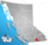
The Regional District of Kootenay Boundary (RDKB) is a regional district in the province of British Columbia
, Canada
. As of the 2006 census
, the population
was 30,742. The area
is 8,095.62 km² (3,125.74 sq mi). The regional district's offices are in the city of Trail
. Other major population centers include the cities of Grand Forks
and Rossland
, and the villages of Fruitvale
, Warfield
, and Montrose
.
British Columbia
British Columbia is the westernmost of Canada's provinces and is known for its natural beauty, as reflected in its Latin motto, Splendor sine occasu . Its name was chosen by Queen Victoria in 1858...
, Canada
Canada
Canada is a North American country consisting of ten provinces and three territories. Located in the northern part of the continent, it extends from the Atlantic Ocean in the east to the Pacific Ocean in the west, and northward into the Arctic Ocean...
. As of the 2006 census
Census
A census is the procedure of systematically acquiring and recording information about the members of a given population. It is a regularly occurring and official count of a particular population. The term is used mostly in connection with national population and housing censuses; other common...
, the population
Population
A population is all the organisms that both belong to the same group or species and live in the same geographical area. The area that is used to define a sexual population is such that inter-breeding is possible between any pair within the area and more probable than cross-breeding with individuals...
was 30,742. The area
Area
Area is a quantity that expresses the extent of a two-dimensional surface or shape in the plane. Area can be understood as the amount of material with a given thickness that would be necessary to fashion a model of the shape, or the amount of paint necessary to cover the surface with a single coat...
is 8,095.62 km² (3,125.74 sq mi). The regional district's offices are in the city of Trail
Trail, British Columbia
Trail is a city in the West Kootenay region of the Interior of British Columbia, Canada.-Geography:Trail has an area of . The city is located on both banks of the Columbia River, approximately 10 km north of the United States border. This section of the Columbia River valley is located between the...
. Other major population centers include the cities of Grand Forks
Grand Forks, British Columbia
-Schools:Schools in the region are operated by School District 51 Boundary which has its main office in Grand Forks but also serves Midway, Greenwood, Beaverdell, and Rock Creek....
and Rossland
Rossland, British Columbia
Rossland is a city in the West Kootenay region of British Columbia.Tucked high in the Monashee Mountains, Rossland is at an elevation of 1023 metres . Population today is approximately 3500; a number that fluctuates from season to season. The population is at its peak during the winter...
, and the villages of Fruitvale
Fruitvale, British Columbia
Fruitvale is a village located in south-eastern British Columbia in the West Kootenay region.It is located 16 km east of the city of Trail along Highway 3B.-Geography:...
, Warfield
Warfield, British Columbia
Warfield is a village located in southern British Columbia in the West Kootenay region. It is located at the west end of Trail at the bottom of the Rossland hill.-References:...
, and Montrose
Montrose, British Columbia
Montrose is a village located in south-eastern British Columbia in the West Kootenay region.It is located 7 km east of the city of Trail along Highway 3B.-Geography:The village of Montrose is built on a mountain ledge leading to Beaver Valley...
.