

Radegast
Encyclopedia
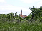
Radegast is a small town in the district
of Anhalt-Bitterfeld
in Saxony-Anhalt
, Germany
. It is the smallest town in Saxony-Anhalt and is located about 13 km south of the district capital of Köthen. Since 1 January 2010, it is part of the town Südliches Anhalt
.
, Wolfen
, Bitterfeld
and Dessau
.
"Cösitzer Teich" in the southeast and on the conservation park
"Fuhneaue" in the south.
. The upper level of this swamp has been quite fertile for a long time. The official Radegast Chronicle
says, "the lower level of the soil in this area is not bad, but its value is lowered because it is too damp." The upper level to a depth of about 0.3 m (0.984251968503937 ft) is meadowland with a lush vegetation of grasses and swampland, which is very fertile and became very calcareous, too because of the stagnant water. This is followed by peat, which was cut for being used as peat coal in former times. The upper level is bordered by an impermeable
stratum of clay
. At shallow depth large boulders can be found from ice age deposits. The quality of the soil became a lot better because of its agricultural
use. It offers perfect conditions for cultivating sugar beet
s and wheat
.
, in the east it is the village Zehbitz
, in the south there is the town of Zörbig
and in the west Radegast is bordering on Cösitz, which is a now part of Zörbig.
formerly named "Siedlung Heimat", built in the early 30's.
 The first written document mentioning "Frates de Radegiz" dates from 1244. In the following centuries, the ownership changed a few times, which was mentioned in some documents. In 1612, Radegast became a princely office. In 1727 the village received market and city rights from Prince Leopold of Anhalt-Dessau
, but the city rights were not exercised until 1852. From 1685 to 1688, a dam was built in the lowland of the river Fuhne between Radegast and Zörbig, which created an important trade-route between the cities of Magdeburg
and Leipzig
. In 1688 a boundary stone named the "Theure Christian" was set at this route. It marked the boundary between the former countries of Saxony
and Anhalt-Dessau
. In 1702 Radegast became a market-town, and in the same year the building of Radegast's first church began. The church-tower collapsed in 1752 and was rebuilt subsequently. Two historical guesthouses were built at that time; both of them exist today.
 From 1780 on a counterfeiter named Ziervogel did his foul work in the town, until he was imprisoned in 1786. In 1820 the imperial post office was opened. In the first years of its existence it was a simple post station for the town of Radegast and the villages Wehlau, Lennewitz, Riesdorf, Cosa, Fernsdorf, Station Weißandt, Priesdorf and Cösitz. In 1929 a telephone exchange was installed. The post office was closed on April 6, 1999.
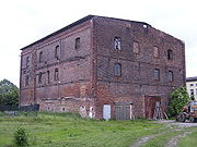 In the following years the town expanded. The number of inhabitants was 885 in 1867. Already in 1859 a liqueur factory was founded, followed by a sugar-refinery in 1860, where up to 120 people worked at its best times. In 1930 the refinery was closed and most of the buildings were pulled down, but some of them exist until today.
 In 1871 an oak tree was planted at the market-place as a symbol for the end of the war between Germany and France, which lasted from 1870 to 1871. The tree called "Friedenseiche" ("oak of peace") is a mark of Radegast today and a natural landmark. Two years later, in 1873, the fire-brigade
of Radegast was founded. In 1874 the nave of the church was rebuilt. The tower of the church was raised to a height of 35 m.
 A railway was opened in 1897 and extended in the following years, but at the end of World War II
the railway history of Radegast came to an end because the railway was disassembled as reparation payment to the Soviet Union. Since 1939 it had transported goods but no more passengers between the towns of Radegast and Zörbig.
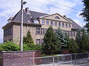 Culture developed in the small town: In 1911 a football team named "Britannia" was founded, followed by a gardeners' club in 1919. In 1925, 911 people lived in the town. Also in this year a new town hall was established. In 1934 the construction work on a new school house started. Only one year later the new school was inaugurated. Students were taught here until the late 1990s.
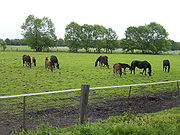 After World War II ended, a new sector of the economy was opened up, as the horse-breeding started at the Radegast domain in 1951. The Radegast stud farm created a lot of prize-winning, successful saddle and sports horses in its history which is rich on tradition. From 1991 on the stud farm was called "Landgestüt des Landes Sachsen-Anhalt" ("official stud farm of Saxony-Anhalt"), but in 1997 the farm was closed, and the "Landgestüt" moved to Prussendorf. In 1999 the Radegast stud farm was sold to private owners.
On April 1, 1994 Radegast joined the "Verwaltungsgemeinschaft Gölzau-Görzig", which was renamed to "Anhalt-Süd" on the same date. Since January 1, 2005 it is called "Verwaltungsgemeinschaft Südliches Anhalt".
. Older versions of the Radegast coat of arms seem to be reversed, because they showed the tower on the left side and the wall on the right.
District
Districts are a type of administrative division, in some countries managed by a local government. They vary greatly in size, spanning entire regions or counties, several municipalities, or subdivisions of municipalities.-Austria:...
of Anhalt-Bitterfeld
Anhalt-Bitterfeld
Anhalt-Bitterfeld is a district in Saxony-Anhalt, Germany. Its capital is Köthen . - History :This district was established by merging the former districts of Bitterfeld, Köthen and a large part of Anhalt-Zerbst as part of the reform of 2007....
in Saxony-Anhalt
Saxony-Anhalt
Saxony-Anhalt is a landlocked state of Germany. Its capital is Magdeburg and it is surrounded by the German states of Lower Saxony, Brandenburg, Saxony, and Thuringia.Saxony-Anhalt covers an area of...
, Germany
Germany
Germany , officially the Federal Republic of Germany , is a federal parliamentary republic in Europe. The country consists of 16 states while the capital and largest city is Berlin. Germany covers an area of 357,021 km2 and has a largely temperate seasonal climate...
. It is the smallest town in Saxony-Anhalt and is located about 13 km south of the district capital of Köthen. Since 1 January 2010, it is part of the town Südliches Anhalt
Südliches Anhalt
Südliches Anhalt was a Verwaltungsgemeinschaft in the Anhalt-Bitterfeld district, in Saxony-Anhalt, Germany. It was situated south and east of Köthen. The seat of the Verwaltungsgemeinschaft was in Weißandt-Gölzau. It was disbanded on 1 January 2010.The Verwaltungsgemeinschaft Südliches Anhalt...
.
Geography
Radegast is located midway between the cities of Köthen (Anhalt)Köthen (Anhalt)
Köthen is a city in Germany. It is the capital of the district of Anhalt-Bitterfeld in Saxony-Anhalt, about north of Halle.Köthen is the location of the main campus and the administrative center of the regional technical university Hochschule Anhalt which is especially strong in information...
, Wolfen
Wolfen
Wolfen may refer to:In geography:* Wolfen, Germany, a town in Saxony-Anhalt, GermanyIn fiction:* The Wolfen, a 1978 horror novel by Whitley Strieber...
, Bitterfeld
Bitterfeld
Bitterfeld is a town in the district Anhalt-Bitterfeld, Saxony-Anhalt, Germany. Since 1 July 2007 it has been part of the town Bitterfeld-Wolfen. It is situated approx. 25 km south of Dessau, and 30 km northeast of Halle...
and Dessau
Dessau
Dessau is a town in Germany on the junction of the rivers Mulde and Elbe, in the Bundesland of Saxony-Anhalt. Since 1 July 2007, it is part of the merged town Dessau-Roßlau. Population of Dessau proper: 77,973 .-Geography:...
.
Geographical Situation
The area of Radegast borders on the national parkNational park
A national park is a reserve of natural, semi-natural, or developed land that a sovereign state declares or owns. Although individual nations designate their own national parks differently A national park is a reserve of natural, semi-natural, or developed land that a sovereign state declares or...
"Cösitzer Teich" in the southeast and on the conservation park
Conservation park
Conservation park is a type of specially protected status for land held by the Crown for conservation purposes.In New Zealand this land is administered by the Department of Conservation and was set up under the Conservation Act 1987. As of 31 March 2005, New Zealand's Conservation parks consisted...
"Fuhneaue" in the south.
Geology
Radegast is situated at the margin of the Köthen culture plain. Here it ascends from the Fuhne valley, so the difference in height is about 6 metres (19.7 ft) on a short distance. The town is situated right in the middle of a former swamplandSwampland
In physics, the term swampland is used in contrast to the term "landscape," to indicate physical theories or aspects of such theories which could be true if gravity wasn't an issue, but which are not compatible with string theory...
. The upper level of this swamp has been quite fertile for a long time. The official Radegast Chronicle
Chronicle
Generally a chronicle is a historical account of facts and events ranged in chronological order, as in a time line. Typically, equal weight is given for historically important events and local events, the purpose being the recording of events that occurred, seen from the perspective of the...
says, "the lower level of the soil in this area is not bad, but its value is lowered because it is too damp." The upper level to a depth of about 0.3 m (0.984251968503937 ft) is meadowland with a lush vegetation of grasses and swampland, which is very fertile and became very calcareous, too because of the stagnant water. This is followed by peat, which was cut for being used as peat coal in former times. The upper level is bordered by an impermeable
Permeability (fluid)
Permeability in fluid mechanics and the earth sciences is a measure of the ability of a porous material to allow fluids to pass through it.- Units :...
stratum of clay
Clay
Clay is a general term including many combinations of one or more clay minerals with traces of metal oxides and organic matter. Geologic clay deposits are mostly composed of phyllosilicate minerals containing variable amounts of water trapped in the mineral structure.- Formation :Clay minerals...
. At shallow depth large boulders can be found from ice age deposits. The quality of the soil became a lot better because of its agricultural
Agriculture
Agriculture is the cultivation of animals, plants, fungi and other life forms for food, fiber, and other products used to sustain life. Agriculture was the key implement in the rise of sedentary human civilization, whereby farming of domesticated species created food surpluses that nurtured the...
use. It offers perfect conditions for cultivating sugar beet
Sugar beet
Sugar beet, a cultivated plant of Beta vulgaris, is a plant whose tuber contains a high concentration of sucrose. It is grown commercially for sugar production. Sugar beets and other B...
s and wheat
Wheat
Wheat is a cereal grain, originally from the Levant region of the Near East, but now cultivated worldwide. In 2007 world production of wheat was 607 million tons, making it the third most-produced cereal after maize and rice...
.
Neighbouring towns and villages
The neighbouring village in the north of Radegast is called Weißandt-GölzauWeißandt-Gölzau
Weißandt-Gölzau is a village and a former municipality in the district of Anhalt-Bitterfeld, in Saxony-Anhalt, Germany. Since 1 January 2010, it is part of the town Südliches Anhalt....
, in the east it is the village Zehbitz
Zehbitz
Zehbitz is a village and a former municipality in the district of Anhalt-Bitterfeld, in Saxony-Anhalt, Germany. Since 1 January 2010, it is part of the town Südliches Anhalt....
, in the south there is the town of Zörbig
Zörbig
' is a town in the district of Anhalt-Bitterfeld in Saxony-Anhalt, Germany. It is situated approx. 15 km west of Bitterfeld, and 20 km northeast of Halle . Zörbig is well-known for its molasses made from sugar beets....
and in the west Radegast is bordering on Cösitz, which is a now part of Zörbig.
City structure
The town encloses the historical town centre and a housing estateHousing estate
A housing estate is a group of buildings built together as a single development. The exact form may vary from country to country. Accordingly, a housing estate is usually built by a single contractor, with only a few styles of house or building design, so they tend to be uniform in appearance...
formerly named "Siedlung Heimat", built in the early 30's.
History
Leopold I, Prince of Anhalt-Dessau
Leopold I, Prince of Anhalt-Dessau was a German prince of the House of Ascania and ruler of the principality of Anhalt-Dessau. He was also a Generalfeldmarschall in the Prussian army...
, but the city rights were not exercised until 1852. From 1685 to 1688, a dam was built in the lowland of the river Fuhne between Radegast and Zörbig, which created an important trade-route between the cities of Magdeburg
Magdeburg
Magdeburg , is the largest city and the capital city of the Bundesland of Saxony-Anhalt, Germany. Magdeburg is situated on the Elbe River and was one of the most important medieval cities of Europe....
and Leipzig
Leipzig
Leipzig Leipzig has always been a trade city, situated during the time of the Holy Roman Empire at the intersection of the Via Regia and Via Imperii, two important trade routes. At one time, Leipzig was one of the major European centres of learning and culture in fields such as music and publishing...
. In 1688 a boundary stone named the "Theure Christian" was set at this route. It marked the boundary between the former countries of Saxony
Saxony
The Free State of Saxony is a landlocked state of Germany, contingent with Brandenburg, Saxony Anhalt, Thuringia, Bavaria, the Czech Republic and Poland. It is the tenth-largest German state in area, with of Germany's sixteen states....
and Anhalt-Dessau
Anhalt-Dessau
Anhalt-Dessau was a principality and later a duchy located in Germany. It was created in 1396 following the partition of the Principality of Anhalt-Zerbst. The capital of the state was Dessau. Anhalt-Dessau experienced a number of partitions throughout its existence with Anhalt-Köthen being...
. In 1702 Radegast became a market-town, and in the same year the building of Radegast's first church began. The church-tower collapsed in 1752 and was rebuilt subsequently. Two historical guesthouses were built at that time; both of them exist today.
Firefighter
Firefighters are rescuers extensively trained primarily to put out hazardous fires that threaten civilian populations and property, to rescue people from car incidents, collapsed and burning buildings and other such situations...
of Radegast was founded. In 1874 the nave of the church was rebuilt. The tower of the church was raised to a height of 35 m.
World War II
World War II, or the Second World War , was a global conflict lasting from 1939 to 1945, involving most of the world's nations—including all of the great powers—eventually forming two opposing military alliances: the Allies and the Axis...
the railway history of Radegast came to an end because the railway was disassembled as reparation payment to the Soviet Union. Since 1939 it had transported goods but no more passengers between the towns of Radegast and Zörbig.
On April 1, 1994 Radegast joined the "Verwaltungsgemeinschaft Gölzau-Görzig", which was renamed to "Anhalt-Süd" on the same date. Since January 1, 2005 it is called "Verwaltungsgemeinschaft Südliches Anhalt".
Coat of Arms
The coat of arms of Radegast has a silver background and shows a red tower on the right side. Nearby the tower there is an ascending red wall with a closed golden gate. Upon the wall there walks a black bear with a crown on its head and a collar around the neck. By giving Radegast the market and city rights, Prince Leopold of Anhalt-Dessau also gave the town this coat of arms, which is similar to that of BernburgBernburg
Bernburg is a town in Saxony-Anhalt, Germany, capital of the district of Salzlandkreis. It is situated on the river Saale, approx. 30 km downstream from Halle. The town is dominated by its huge Renaissance castle featuring a museum as well as a popular, recently updated bear pit in its...
. Older versions of the Radegast coat of arms seem to be reversed, because they showed the tower on the left side and the wall on the right.
Culture and Tourism
Culture in Radegast bears the imprint of club and society activities until today. The Radegast society for local history and traditional costumes takes care of the traditions.Museums
In Radegast there is a little parlour for local history where visitors can experience how people lived in Anhalt in the old days. The town also has a new-built false coinery. New coins with historical motives of Radegast are made for collectors every year.Important historical buildings
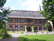
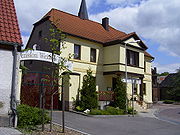
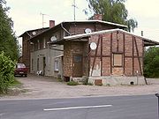
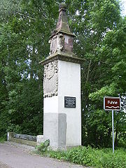
One of the eldest verifications of Radegasts town history can be found at the former connection road between Radegast and Zörbig. It is an architectural monument, called the "Theure Christian". But there are a lot of other historical buildings in Radegast as well: There are the two old guesthouses "Prinz von Anhalt" ("Prince of Anhalt") and "Das weiße Ross" ("The White Horse"). Other historical monuments are the former imperial post station and the old railway station. The typical homogeneous method of constructionwhich was uses in old Anhalt, can be seen at the historical market place until today.Parks
The "Bürgerpark" can be found at the settlement. Also the meadow of the river Fuhne and the near national park “Cösitzer Teich” invite wanderers and friends of mother nature.Natural Monuments
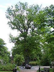
The "Friedenseiche" in the middle of the market place – about 135 years old – is a natural monument. It is also a symbol for the end of war between Germany and France in the years 1870 to 1871.Institutions
In Radegast cand be found several institutions:- a fire-brigade
- a savings bank
- a centre for leisure-time activities
- a police station
- a kindergarten
- a primary school and
- a teen’s club house
Honorary citizens
- Louis Hecht (November 11, 1841 – January 11, 1931) – He was a miller and the mayor of Radegast from 1891 to 1925. He had to leave his position as mayor of the town because of his old age. The town thanked him for his good job and made and appointed him honorary citizen. After his death he was buried at the Radegast graveyard.
Famous sons and daughters
- Horst Caspar (January 20, 1913 – December 27, 1952) – He was born in Radegast as son of an army officer and became a famous actor in films and in theatres in the 1930s and 1940s.
Important inhabitants
- Franz Paul Baege (November 25, 1876 – December 1, 1938 – Baege was a teacher, regional poet and archaeologist. He wrote the dialectal novel book "Die Helden vom Dideldei" ("Heroes of the Dideldei" to some extent) and worked in Radegast as a teacher and as headmaster of the school from 1908 to 1933. He was buried at the Radegast graveyard, too.
- Franz Ebert (May 1, 1877 – December 21, 1936) – He worked as a bricklayer and was a representative of the social democrats in the Radegast town council. Ebert founded the gardener’s club in 1919 and fought for the rights of the poor. He was buried at the Radegast graveyard, too. Today there is a street called "Franz-Ebert-Straße" in the town.
External links
- Verwaltungsgemeinschaft Südliches Anhalt (German)
- Still gelegt, page dedicated to closed railway lines. The "Dessau-Radegast-Köthener Bahn" can be found here, too. (German)
- Aus der anhaltischen Eisenbahngeschichte – Die Dessau-Radegast-Köthener Bahn (DRKB) (German)
- Das Köthener Land (German)
- Radegast stud farm (German)