

Puerto Rico Highway 10
Encyclopedia
Puerto Rico Highway 10 is a major highway in Puerto Rico
. It connects the cities of Ponce
in the south and Arecibo
to the north; it is also the shortest route between the two cities.
Construction on the modern PR-10, a new 68.26 kilometres (42.4 mi) highway, began in 1974. The highway is being built parallel to the old PR-10; that road is now signed PR-123
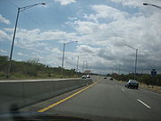
. Most of the new PR-10 is now complete, with an approximately 10 kilometres (6.2 mi) stretch still remaining to be finished. In its current state it is a freeway only in the completed portions, which consists of over three-fourths of the highway.
PR-10 is anticipated to be completed in 2015, at a cost of $500 million. Upon completion the highway will become one of the two major roads on the island that cross the Cordillera Central
mountain range.
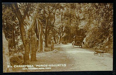
PR-123 dates to the late 19th century when it was built under the colonial government of Spain to connect the coffee-growing town of Adjuntas
to the port city of Ponce as a farm-to-market road.
When the PR-10 road started construction in the mid 1970s, the then Ponce-Arecibo Road, which used to be signed PR-10, was resigned PR-123 and the new road was signed PR-10. Today, PR-10 signs refer to the new road, whereas PR-123 signs refer to the old road. The old road is roughly parallel to the new PR-10. The exception to this is in the area between the towns of Adjuntas and Utuado, where construction of PR-10 is not yet complete and traffic is detoured to use the PR-123. In that area PR-10 signs identify the old road. Prior to 1974, the full length of the old road was, in fact, signed PR-10. This route signing can still be seen in some old street maps of the city of Ponce.
Navigating the old Ponce-Arecibo road was very tedious as the road was engineered to run from mountainside to mountainside, following the contours of the mountains, and along the natural definitions of the course of rivers, to reach its destination. Driving was rather hazardous, especially for trucks.
started planning for the construction this road to connect the cities of Ponce and Arecibo. While one of the main reasons to build the new PR-10 was to facilitate the movement of trucks in the mineral exploitation of the area, such exploitation met with considerable opposition from environmental advocates and today the road is being built to promote other types of socio-economic developments, such as those associated with the Port of the Americas.
. It takes about half hour travel on PR-123 to reach the new PR-10 road, and about one hour and 20 minutes to travel the full length of the road from Ponce to Arecibo. Before the building of the new PR-10 highway, just the stretch from Utuado to Arecibo used to take one hour to travel; it now takes 15 minutes.
leading to a 24-hour closure of the highway. It was the second time that heavy rains had caused rocks to fall onto the highway in a period of a few months. Meanwhile northbound traffic was detoured to PR-515 and southbound traffic was detoured to PR-123, the old PR10-signed road. As a result, the Puerto Rico DTOP
is assessing whether the area would be a candidate for the installation of metal nets that would minimize the possibility of further erosion.
The frequent rain and high humidity as well as the mountainous terrain of the area traversed by PR-10 make for a road building challenge for road engineers who have come to the use of recycled ground vehicular rubber tires as a innovative solution.
, providing magnificent views of the surrounding mountain tops in the distance. "The road is of first class construction throughout, and presents a panorama of magnificent scenery, rivaling the views of any of the famed roads of Europe." Several sections of the new highway require the construction of bridges. The new road will reduce travel time.
, at the entrance to Mercedita Airport
. For its first four miles it runs in a northwesternly fashion, just north of the city of Ponce, bypassing city traffic. The road crosses barrio Sabanetas, where it has an interchange with PR-52 which leads to Mayaguez and San Juan
. The road also crosses barrio Machuelo Abajo
, where it has an interchange with PR-14 which leads to downtown Ponce and Coamo. The road then crosses barrio Machuelo Arriba
, where it has an interchange with PR-505 which leads to downtown Ponce and barrio San Patricio
. Further west the road then crosses barrio Portugues
, where it has an interchange with PR-503 which leads south to downtown Ponce and north to barrio San Patricio and to barrio Consejo in southern Jayuya. In the same interchange area there is also access to PR-504 which leads to downtown Ponce and to the northern areas of barrio Portugues
. The road then enters barrio Portugues Urbano
where it meets with the northern terminus of PR-9 which leads to PR-2
in Ponce's barrio Canas.
 At this point PR-10 turns sharply north and heads into the mountains of barrio Tibes
. Half way through Tibes it intersects PR-503. It runs shortly through barrio San Patricio before entering barrio Guaraguao
. As it enters barrio Guaraguao, the road intersects with PR-515 which leads to PR-123, the old road between Ponce and Arecibo. Continuing on its northernly course, PR-10 then enters the municipality of Adjuntas via Adjuntas' barrio Portugues, the barrio where Ponce's Rio Portugues has its origin. As the road exits Adjuntas' barrio Portugues and enters barrio Saltillo, it intersects with Puerto Rico's Panoramic Route
, PR-143, which leads to downtown Adjuntas and Barranquitas. As it continues north bypassing the town of Adjuntas, PR-10 intesects with PR-521 leading to downtown Adjuntas and to PR-143. The road continues north but shortly thereafter it comes to an abrupt end as a freeway, and motorists must detour by exiting into the narrower PR-5516. After a neglegible run south on PR-5516, a road signed PR-5518 is used to continue the detour into the old PR-10, now signed PR-123, and which will continue to head north as the temporary route back onto the new limited access PR-10.
PR-10 continues north intersecting with PR-135 that leads west to Lake Guayo, located between Adjuntas and Lares. It continues north for approximately 15 miles before reaching the new PR-10 again just before reaching the town of Utuado. In this stretch of the road, construction of the new PR-10 is visible, interchangeably to both the left and right sides of PR-123, as the new road carves its way through the mountains. Río Grande de Arecibo
has its origin in this area and is visible mostly to the east of PR-123. In this stretch of the road, Puerto Rico Highway 123 intersects with PR-524, leading west to Jayuya. About one-half mile before entering the town of Utuado, PR-123 intersects with PR-603 which provides the access for motorists to re-enter the new PR-10 again. The new PR-10 bypasses downtown Utuado and heads towards Arecibo.
, in the lower Central Karst Zone, and east to downtown Utuado and on to Caonillas Lake west of Utuado. The roads continues north and it intersect the old road to Arecibo, PR-123. Further north the road also intersects PR-621 which leads to PR-146 and Dos Bocas Lake, a major source of hydroelectricity. Traversing the Central Karst Zone, PR-10 follows a course parallel to Rio Grande de Arecibo. A connection road, PR-6626 provides access to PR-626, which leads to various rural Arecibo barrios. Continuing north, PR-10 exits the mountain area, reaching Puerto Rico's northern coastal valleys, and intersects again with PR-123, in the area of San Pedro. Shortly after this point, the road becomes a divide highway. Further north, the road intersects with PR-651 for access to Hatillo
. Another intersection, PR-652, provides access to the communities in the southern edge of the city of Arecibo, and leads to the Arecibo Observatory
. The road then has an interchange
with PR-22, the main limited access highway on Puerto Rico's northern coast. A little over a mile later, PR-10 comes to an end as it intersects with PR-2
.
.
Puerto Rico
Puerto Rico , officially the Commonwealth of Puerto Rico , is an unincorporated territory of the United States, located in the northeastern Caribbean, east of the Dominican Republic and west of both the United States Virgin Islands and the British Virgin Islands.Puerto Rico comprises an...
. It connects the cities of Ponce
Ponce, Puerto Rico
Ponce is both a city and a municipality in the southern part of Puerto Rico. The city is the seat of the municipal government.The city of Ponce, the fourth most populated in Puerto Rico, and the most populated outside of the San Juan metropolitan area, is named for Juan Ponce de León y Loayza, the...
in the south and Arecibo
Arecibo, Puerto Rico
Arecibo is a municipality in the northern midwest coast of Puerto Rico and located by the Atlantic Ocean, north of Utuado and Ciales; east of Hatillo; and west of Barceloneta, and Florida. Arecibo is spread over 18 wards and Arecibo Pueblo...
to the north; it is also the shortest route between the two cities.
Construction on the modern PR-10, a new 68.26 kilometres (42.4 mi) highway, began in 1974. The highway is being built parallel to the old PR-10; that road is now signed PR-123
Puerto Rico Highway 123
Puerto Rico Highway 123 is a secondary highway that connects the city Arecibo to the city of Ponce. It runs through the towns of Utuado and Adjuntas, before reaching Ponce...
. Most of the new PR-10 is now complete, with an approximately 10 kilometres (6.2 mi) stretch still remaining to be finished. In its current state it is a freeway only in the completed portions, which consists of over three-fourths of the highway.
PR-10 is anticipated to be completed in 2015, at a cost of $500 million. Upon completion the highway will become one of the two major roads on the island that cross the Cordillera Central
Cordillera Central, Puerto Rico
The Cordillera Central, or La Cordillera Central , is the main mountain range in Puerto Rico. Generally speaking, the range crosses the island from west to east with an average elevation of 915m and divides the territory's northern and southern coastal plains.La Cordillera Central runs east to...
mountain range.
History
First road
The history of PR-10 is closely linked to PR-123 (the old Ponce-to-Adjuntas Road) which predates it.PR-123 dates to the late 19th century when it was built under the colonial government of Spain to connect the coffee-growing town of Adjuntas
Adjuntas, Puerto Rico
Adjuntas is a small mountainside municipality in Puerto Rico located central midwest of the island on the Central Mountain range , north of Yauco, Guayanilla and Peñuelas; southeast of Utuado; east of Lares and Yauco; and west of Ponce. Adjuntas is spread over 16 wards and Adjuntas Pueblo...
to the port city of Ponce as a farm-to-market road.
When the PR-10 road started construction in the mid 1970s, the then Ponce-Arecibo Road, which used to be signed PR-10, was resigned PR-123 and the new road was signed PR-10. Today, PR-10 signs refer to the new road, whereas PR-123 signs refer to the old road. The old road is roughly parallel to the new PR-10. The exception to this is in the area between the towns of Adjuntas and Utuado, where construction of PR-10 is not yet complete and traffic is detoured to use the PR-123. In that area PR-10 signs identify the old road. Prior to 1974, the full length of the old road was, in fact, signed PR-10. This route signing can still be seen in some old street maps of the city of Ponce.
Navigating the old Ponce-Arecibo road was very tedious as the road was engineered to run from mountainside to mountainside, following the contours of the mountains, and along the natural definitions of the course of rivers, to reach its destination. Driving was rather hazardous, especially for trucks.
New road
One of the reasons to build a new road was the expected use by large trucks which the old road could not accommodate. Also, as traffic on the old road increased in the 1950s and 1960s, that road started to show its limits. To ameliorate the situation, in 1974 the Puerto Rico Department of Transportation and Public WorksPuerto Rico Department of Transportation and Public Works
The Puerto Rico Department of Transportation and Public Works is a government agency of Puerto Rico regulating transportation and public works. The agency's headquarters are located in San Juan.-External links:*...
started planning for the construction this road to connect the cities of Ponce and Arecibo. While one of the main reasons to build the new PR-10 was to facilitate the movement of trucks in the mineral exploitation of the area, such exploitation met with considerable opposition from environmental advocates and today the road is being built to promote other types of socio-economic developments, such as those associated with the Port of the Americas.
Cost
The new Puerto Rico Highway 10 is being built in three segments and, as of November 2010, only the middle segment remained to be built. The first segment, the road from Utuado to Arecibo was built at a cost of $120 million; the second segment, the road from Ponce to Adjuntas, was built at a cost of $80 million. The remaining segment, from Adjuntas to Utuado, is partly complete. Due to the complexities of road-building in the remaining segment, this last segment is being built in nine phases. The first phase, consisting of 1.24 km of roadway, was completed at a cost of $7.9 million and opened to the public on August 21, 2009. Phases 2 and 3 were already also under construction at the time that the beginning of phase 4 was announced on August 25, 2010. Phase 4 will cost of $8.7 million. At that juncture, phase 5 was being readied for bidding. The last four phases were under engineering design in August 2010. The total cost of these last five phases (phases 5 through 9) is projected to be $179 million.Travel time
The new road runs mostly parallel to PR-123, and for the area that is still under construction, motorists must use a stretch of PR-123 before reaching PR-10 again. The incomplete stretch will link Adjuntas to the mountain town of UtuadoUtuado, Puerto Rico
Utuado is a municipality of Puerto Rico located in the central-western mountainous region of the island known as La Cordillera Central. It is located north of Adjuntas and Ponce; south of Hatillo and Arecibo; east of Lares; and west of Ciales and Jayuya. In land area it is the third-largest...
. It takes about half hour travel on PR-123 to reach the new PR-10 road, and about one hour and 20 minutes to travel the full length of the road from Ponce to Arecibo. Before the building of the new PR-10 highway, just the stretch from Utuado to Arecibo used to take one hour to travel; it now takes 15 minutes.
Possible addition of metal nets
On November 8, 2010, large rocks fell on a section of the new PR-10 in barrio TibesTibes
Tibes is one of the 31 barrios in the municipality of Ponce, Puerto Rico. Together with Magueyes, Portugues, Monte Llano, Maragüez, Machuelo Arriba, Sabanetas, and Cerrillos, Tibes is one of the municipality's eight rural interior barrios...
leading to a 24-hour closure of the highway. It was the second time that heavy rains had caused rocks to fall onto the highway in a period of a few months. Meanwhile northbound traffic was detoured to PR-515 and southbound traffic was detoured to PR-123, the old PR10-signed road. As a result, the Puerto Rico DTOP
Puerto Rico Department of Transportation and Public Works
The Puerto Rico Department of Transportation and Public Works is a government agency of Puerto Rico regulating transportation and public works. The agency's headquarters are located in San Juan.-External links:*...
is assessing whether the area would be a candidate for the installation of metal nets that would minimize the possibility of further erosion.
Environmental concerns
The building of the new PR-10 was an issue of contention based on environmental reasons related to the effect on the virgin Cordillera Central. When a group of American corporations attempted to lease land from the Government of Puerto Rico to exploit nickel, copper and cobalt mines, a grassroots effort by Puerto Rican townspeople had the government turn away from the idea. The plan had its roots in a so-called Plan 2020, the result of a study by a group of U.S. consultants eyeing economic regeneration for Puerto Rico at the expense of the environment.The frequent rain and high humidity as well as the mountainous terrain of the area traversed by PR-10 make for a road building challenge for road engineers who have come to the use of recycled ground vehicular rubber tires as a innovative solution.
Fate of the old road
No plans have been disclosed to close the old PR-123 after the new PR-10 construction project is complete, and PR-123 will likely serve mostly as a local route. Today, the old highway is signed as PR-123 in those stretches of the road where the newer PR-10 parallels it. As new stretches of the PR-10 road are completed and opened to traffic, the corresponding stretch of the old PR-10 road is being signed PR-123.Route description
PR-10 runs over the scenic mountains of the Cordillera CentralCordillera Central, Puerto Rico
The Cordillera Central, or La Cordillera Central , is the main mountain range in Puerto Rico. Generally speaking, the range crosses the island from west to east with an average elevation of 915m and divides the territory's northern and southern coastal plains.La Cordillera Central runs east to...
, providing magnificent views of the surrounding mountain tops in the distance. "The road is of first class construction throughout, and presents a panorama of magnificent scenery, rivaling the views of any of the famed roads of Europe." Several sections of the new highway require the construction of bridges. The new road will reduce travel time.
Ponce to Adjuntas
PR-10 starts at PR-5506, near PR-1Puerto Rico Highway 1
Puerto Rico Highway 1 connects the city of Ponce to San Juan. Leaving Ponce, the road follows somewhat parallel along the southern coast of the island and, at Salinas, it turns north to cut through the Cordillera Central in its approach to San Juan....
, at the entrance to Mercedita Airport
Mercedita Airport
Mercedita Airport is a commercial airport located three miles east of the central business district of Ponce, Puerto Rico. The airport covers and has one runway. Passenger movement at the airport in FY 2008 was 278,911, an astounding 1,228% increase over fiscal year 2003 and the highest of all...
. For its first four miles it runs in a northwesternly fashion, just north of the city of Ponce, bypassing city traffic. The road crosses barrio Sabanetas, where it has an interchange with PR-52 which leads to Mayaguez and San Juan
San Juan, Puerto Rico
San Juan , officially Municipio de la Ciudad Capital San Juan Bautista , is the capital and most populous municipality in Puerto Rico, an unincorporated territory of the United States. As of the 2010 census, it had a population of 395,326 making it the 46th-largest city under the jurisdiction of...
. The road also crosses barrio Machuelo Abajo
Machuelo Abajo
Machuelo Abajo is one of the 31 barrios of the municipality of Ponce, Puerto Rico. Along with Canas Urbano, Magueyes Urbano, Portugués Urbano, and San Antón, Machuelo Abajo is one of the municipality's five originally rural barrios that are now also part of the urban zone of the city of...
, where it has an interchange with PR-14 which leads to downtown Ponce and Coamo. The road then crosses barrio Machuelo Arriba
Machuelo Arriba
Machuelo Arriba is one of the 31 barrios of the municipality of Ponce, Puerto Rico. Along with the barrios of Magueyes, Tibes, Portugués, Monte Llano, Maragüez, and Cerrillos, Machuelo Arriba is one of the municipality's seven rural interior barrios....
, where it has an interchange with PR-505 which leads to downtown Ponce and barrio San Patricio
San Patricio (Ponce)
San Patricio is one of the 31 barrios of the municipality of Ponce, Puerto Rico. Along with Anón, Coto Laurel, Guaraguao, Quebrada Limón, Real, and Marueño, and the coastal barrios of Canas and Capitanejo, San Patricio is one of the municipality's nine bordering barrios...
. Further west the road then crosses barrio Portugues
Portugués
Portugués is one of the 31 barrios in the municipality of Ponce, Puerto Rico. Along with Magueyes, Tibes, Monte Llano, Maragüez, Machuelo Arriba, Sabanetas, and Cerrillos, Portugués is one of the municipality's eight rural interior barrios.-Location:Portugués is a mountainous rural barrio located...
, where it has an interchange with PR-503 which leads south to downtown Ponce and north to barrio San Patricio and to barrio Consejo in southern Jayuya. In the same interchange area there is also access to PR-504 which leads to downtown Ponce and to the northern areas of barrio Portugues
Portugués
Portugués is one of the 31 barrios in the municipality of Ponce, Puerto Rico. Along with Magueyes, Tibes, Monte Llano, Maragüez, Machuelo Arriba, Sabanetas, and Cerrillos, Portugués is one of the municipality's eight rural interior barrios.-Location:Portugués is a mountainous rural barrio located...
. The road then enters barrio Portugues Urbano
Portugués Urbano
Portugués Urbano is one of the 31 barrios in the municipality of Ponce, Puerto Rico. Along with Canas Urbano, Machuelo Abajo, Magueyes Urbano, and San Antón, Portugués Urbano is one of the municipality's five originally rural barrios that are now also part of the urban zone of the city of...
where it meets with the northern terminus of PR-9 which leads to PR-2
Puerto Rico Highway 2
Puerto Rico Highway 2, the longest highway in the Commonwealth of Puerto Rico at about 156 miles long, connects San Juan to Ponce....
in Ponce's barrio Canas.
Tibes
Tibes is one of the 31 barrios in the municipality of Ponce, Puerto Rico. Together with Magueyes, Portugues, Monte Llano, Maragüez, Machuelo Arriba, Sabanetas, and Cerrillos, Tibes is one of the municipality's eight rural interior barrios...
. Half way through Tibes it intersects PR-503. It runs shortly through barrio San Patricio before entering barrio Guaraguao
Guaraguao
Guaraguao is one of the 31 barrios in the municipality of Ponce, Puerto Rico. Along with Anón, Coto Laurel, Marueño, Quebrada Limón, Real, and San Patricio, and the coastal barrios of Canas and Capitanejo, Guaraguao is one of the municipality's nine bordering barrios. It borders the...
. As it enters barrio Guaraguao, the road intersects with PR-515 which leads to PR-123, the old road between Ponce and Arecibo. Continuing on its northernly course, PR-10 then enters the municipality of Adjuntas via Adjuntas' barrio Portugues, the barrio where Ponce's Rio Portugues has its origin. As the road exits Adjuntas' barrio Portugues and enters barrio Saltillo, it intersects with Puerto Rico's Panoramic Route
Ruta Panorámica
The Ruta Panorámica , officially the Ruta Panorámica Luis Muñoz Marin , is a network of some 40 secondary highways which traverse the island of Puerto Rico from west to east along its Cordillera Central . Most of the route consists of three roads, PR-105, PR-143, and PR-182...
, PR-143, which leads to downtown Adjuntas and Barranquitas. As it continues north bypassing the town of Adjuntas, PR-10 intesects with PR-521 leading to downtown Adjuntas and to PR-143. The road continues north but shortly thereafter it comes to an abrupt end as a freeway, and motorists must detour by exiting into the narrower PR-5516. After a neglegible run south on PR-5516, a road signed PR-5518 is used to continue the detour into the old PR-10, now signed PR-123, and which will continue to head north as the temporary route back onto the new limited access PR-10.
Adjuntas to Utuado
PR-123/PR-10 is a curvy road that leads to Utuado, the next town before the new PR-10's terminus in Arecibo. At this point the road is traversing some of the tallest peaks of the Cordillera Central. The road presents some spectacular views of the mountains nearby, but probably not as good as those that can be seen traveling the new PR-10, as trees along side the new road have been removed to make for a shoulder and an additional clearing next to the shoulder, and thus removing foliage that blocks the view of the nearby scenery.PR-10 continues north intersecting with PR-135 that leads west to Lake Guayo, located between Adjuntas and Lares. It continues north for approximately 15 miles before reaching the new PR-10 again just before reaching the town of Utuado. In this stretch of the road, construction of the new PR-10 is visible, interchangeably to both the left and right sides of PR-123, as the new road carves its way through the mountains. Río Grande de Arecibo
Río Grande de Arecibo
The Río Grande de Arecibo is a river of Puerto Rico. The headwaters lie in the mountains to the south of Adjuntas. From there it flows north until it reaches the Atlantic Ocean near Arecibo. The tributaries lie along the side of the Cerro de Punta and the Utuado pluton...
has its origin in this area and is visible mostly to the east of PR-123. In this stretch of the road, Puerto Rico Highway 123 intersects with PR-524, leading west to Jayuya. About one-half mile before entering the town of Utuado, PR-123 intersects with PR-603 which provides the access for motorists to re-enter the new PR-10 again. The new PR-10 bypasses downtown Utuado and heads towards Arecibo.
Utuado to Arecibo
PR-10 runs alongside Rio Grande de Arecibo for several miles. The road intersects with PR-111 which leads west to the town of LaresLares
Lares , archaically Lases, were guardian deities in ancient Roman religion. Their origin is uncertain; they may have been guardians of the hearth, fields, boundaries or fruitfulness, hero-ancestors, or an amalgam of these....
, in the lower Central Karst Zone, and east to downtown Utuado and on to Caonillas Lake west of Utuado. The roads continues north and it intersect the old road to Arecibo, PR-123. Further north the road also intersects PR-621 which leads to PR-146 and Dos Bocas Lake, a major source of hydroelectricity. Traversing the Central Karst Zone, PR-10 follows a course parallel to Rio Grande de Arecibo. A connection road, PR-6626 provides access to PR-626, which leads to various rural Arecibo barrios. Continuing north, PR-10 exits the mountain area, reaching Puerto Rico's northern coastal valleys, and intersects again with PR-123, in the area of San Pedro. Shortly after this point, the road becomes a divide highway. Further north, the road intersects with PR-651 for access to Hatillo
Hatillo, Puerto Rico
Hatillo is a municipality located on Puerto Rico's north coast, bordered by the Atlantic Ocean to the north, Lares and Utuado to the south, Camuy to the west, and Arecibo to the east. According to the 2000 US Census Hatillo is spread over 9 wards and Hatillo Pueblo...
. Another intersection, PR-652, provides access to the communities in the southern edge of the city of Arecibo, and leads to the Arecibo Observatory
Arecibo Observatory
The Arecibo Observatory is a radio telescope near the city of Arecibo in Puerto Rico. It is operated by SRI International under cooperative agreement with the National Science Foundation...
. The road then has an interchange
Interchange (road)
In the field of road transport, an interchange is a road junction that typically uses grade separation, and one or more ramps, to permit traffic on at least one highway to pass through the junction without directly crossing any other traffic stream. It differs from a standard intersection, at which...
with PR-22, the main limited access highway on Puerto Rico's northern coast. A little over a mile later, PR-10 comes to an end as it intersects with PR-2
Puerto Rico Highway 2
Puerto Rico Highway 2, the longest highway in the Commonwealth of Puerto Rico at about 156 miles long, connects San Juan to Ponce....
.
Future
The new highway is anticipated to be completed by 2015 at a cost of $500 million. When the new PR-10 highway is completed, travel time between Ponce and Arecibo will be significantly reduced. The new PR-10 provides a second safe route to cross the island from north to south, in addition to PR-52. Except for a 1.65 kilometres (1 mi) stretch of road between km 13.45 and km 15.10, where the road is only two lanes wide, the road is either a three- or four-lane highway. The road is listed as part of the National Highway SystemNational Highway System (United States)
The National Highway System is a network of strategic highways within the United States, including the Interstate Highway System and other roads serving major airports, ports, rail or truck terminals, railway stations, pipeline terminals and other strategic transport facilities.Individual states...
.