

Puerto Rico Highway 123
Encyclopedia
Puerto Rico Highway 123 is a secondary highway that connects the city Arecibo
to the city of Ponce
. It runs through the towns of Utuado and Adjuntas, before reaching Ponce. A parallel road is being built, PR-10, that is expected to take on most of the traffic currently using PR-123.
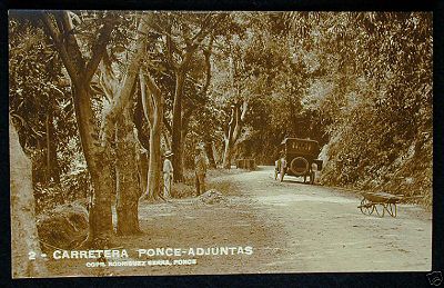 The road dates from the late 19th century and it started as a road to link the coffee-farming mountain town of Adjuntas to the southern port city of Ponce for the export of coffee. Eventually the road was completed to the smaller northern port city of Arecibo as well, connecting the mountain town of Utuado in its way.
PR-123 was built under the colonial government of Spain in Puerto Rico to connect the coffee-growing town of Adjuntas
to the port city of Ponce as a farm-to-market road.
The construction of the first Ponce to Adjuntas road got underway through the dedicated efforts of local political leader, attorney, and composer Olimpio Otero
in the late nineteenth century. In 1903, the Puerto Rico Legislature named a bridge on the Ponce to Adjuntas section of the road to his memory for his outstanding dedication to the building of that stretch of the road. The bridge is located in the Magueyes
barrio of the municipality of Ponce.
True to its farm-to-market purpose, PR-123 was designed to descend from the mountain town of Adjuntas and make its way through the Cordillera Central until it reached the city of Ponce, edging Plaza Las Delicias
, located just two blocks from the Plaza del Mercado de Ponce
fruits-and-vegetables central market place. The road then continued south to the port of Ponce where coffee and other farm products were shipped to the United States and Europe.
Prior to the construction of a new road (see PR-10) that took its number, the road was signed "PR-10". This route signing for this old, winding road can still be seen in some old street maps of the city of Ponce.
The stretch from Ponce to Adjuntas was built under the Spanish government. The remainder of the route to Arecibo was built after the Americans took over in 1898. This second stretch opened on July 1, 1904. The whole course of the road from its southern end in Ponce to its northern end in Arecibo was signed as Road No. 6 in those days.
Navigating this first PR-10 road was very tedious as the road was engineered to run from mountainside to mountainside, following the contours of the mountains, and along the natural definitions of the course of rivers, to reach its destination. Such design, however, limited considerably the speed of travel. It was also necessary to drive through the congested downtown areas of the various towns and villages in the way to get from one terminus of the road to the other, something that proved to be very time-consuming as vehicular traffic in those towns and villages increased. Despite these drawbacks, the road was heavily used for many decades. However, as traffic on this road increased in the 1950s and 1960s, the road started to show its limits.
Arecibo
Arecibo may refer to:*Arecibo, Puerto Rico, a municipality located by the Atlantic Ocean*Arecibo Observatory, a very sensitive radio telescope located approximately south-southwest from the city of Arecibo...
to the city of Ponce
Ponce, Puerto Rico
Ponce is both a city and a municipality in the southern part of Puerto Rico. The city is the seat of the municipal government.The city of Ponce, the fourth most populated in Puerto Rico, and the most populated outside of the San Juan metropolitan area, is named for Juan Ponce de León y Loayza, the...
. It runs through the towns of Utuado and Adjuntas, before reaching Ponce. A parallel road is being built, PR-10, that is expected to take on most of the traffic currently using PR-123.
History
PR-123 was built under the colonial government of Spain in Puerto Rico to connect the coffee-growing town of Adjuntas
Adjuntas, Puerto Rico
Adjuntas is a small mountainside municipality in Puerto Rico located central midwest of the island on the Central Mountain range , north of Yauco, Guayanilla and Peñuelas; southeast of Utuado; east of Lares and Yauco; and west of Ponce. Adjuntas is spread over 16 wards and Adjuntas Pueblo...
to the port city of Ponce as a farm-to-market road.
The construction of the first Ponce to Adjuntas road got underway through the dedicated efforts of local political leader, attorney, and composer Olimpio Otero
Olimpio Otero
Olimpio Otero Vergés was a merchart, attorney, composer, musical editor, and a political leader in Ponce, Puerto Rico.-Merchant:As a merchant, Otero Vergés led the Agricultural and Industrial Tabacco Exposition held in Ponce in 1883, just a year after the successful 1882 Exposition Fair that was...
in the late nineteenth century. In 1903, the Puerto Rico Legislature named a bridge on the Ponce to Adjuntas section of the road to his memory for his outstanding dedication to the building of that stretch of the road. The bridge is located in the Magueyes
Magueyes
Magueyes is one of the 31 barrios of the municipality of Ponce, Puerto Rico. Together with Cerrillos, Machuelo Arriba, Maragüez, Monte Llano, Portugues, Sabanetas, and Tibes, Magueyes is one of the municipality's eight interior barrios. The name of this barrio is of native Indian...
barrio of the municipality of Ponce.
True to its farm-to-market purpose, PR-123 was designed to descend from the mountain town of Adjuntas and make its way through the Cordillera Central until it reached the city of Ponce, edging Plaza Las Delicias
Plaza Las Delicias
Plaza Las Delicias is the main plaza in the city of Ponce, Puerto Rico. The square is notable for its fountains and for the various monuments it contains. The historic Parque de Bombas and Ponce Cathedral buildings are located within Plaza Las Delicias. Plaza Las Delicias is actually composed of...
, located just two blocks from the Plaza del Mercado de Ponce
Plaza del Mercado de Ponce
The Plaza del Mercado de Ponce, or, formally, Plaza del Mercado Isabel II is a historic marketplace building in Ponce, Puerto Rico. It was inaugurated in 1863 by Ponce Mayor Don Luis de Quixano. The building was designed by famed engineer Timoteo Luberza...
fruits-and-vegetables central market place. The road then continued south to the port of Ponce where coffee and other farm products were shipped to the United States and Europe.
Prior to the construction of a new road (see PR-10) that took its number, the road was signed "PR-10". This route signing for this old, winding road can still be seen in some old street maps of the city of Ponce.
The stretch from Ponce to Adjuntas was built under the Spanish government. The remainder of the route to Arecibo was built after the Americans took over in 1898. This second stretch opened on July 1, 1904. The whole course of the road from its southern end in Ponce to its northern end in Arecibo was signed as Road No. 6 in those days.
Navigating this first PR-10 road was very tedious as the road was engineered to run from mountainside to mountainside, following the contours of the mountains, and along the natural definitions of the course of rivers, to reach its destination. Such design, however, limited considerably the speed of travel. It was also necessary to drive through the congested downtown areas of the various towns and villages in the way to get from one terminus of the road to the other, something that proved to be very time-consuming as vehicular traffic in those towns and villages increased. Despite these drawbacks, the road was heavily used for many decades. However, as traffic on this road increased in the 1950s and 1960s, the road started to show its limits.
External links
- Arecibo-Ponce Road c. 1930
- The Ponce-Adjuntas Road c. 1940s–1950s
- Juana Matos Bridge in Barrio Magueyes, Ponce, Puerto Rico c. 1908
- Another view of the Juana Matos Bridge on the Ponce-Adjuntas Road in Barrio Magueyes, Ponce, Puerto Rico c. 1908
- Abandoned Bus Stop at the intersection of PR-123 and PR-524 in Barrio Pellejas, Adjuntas