

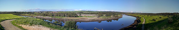
Onkaparinga River
Encyclopedia
The Onkaparinga River runs from its source between Mount Torrens and Charleston
in the Mount Lofty Ranges
, and flows south westerly to an estuary at Port Noarlunga. The catchment is over 500 km² in area, and is in part located in the Onkaparinga River National Park
.
The Onkaparinga River is the second major river of the Adelaide
region, after the River Torrens
. The name derives from the Indigenous Kaurna name Ngangiparri which translates as "The Women's River". In 1837 William Light
named it Field's River, or the Field River, after Lieut William George Field RN (1804-1850) of the brig Rapid, who carried out the first surveys in the vicinity, but Governor George Gawler
soon reinstated the Indigenous name.
It is a source of fresh water for the city, Mount Bold Reservoir
was constructed between 1932 and 1938 along a section of its path approximately 20km inland. Much of its flow diverted via a tunnel from the Clarendon Weir
to the Happy Valley Reservoir
, that in turn supplies some 40 per cent of Adelaide's water supply. Most years the flow to the reservoir is supplemented by water pumped from the River Murray
via a pipeline from Murray Bridge
.
Downstream from Mount Bold Reservoir is the Clarendon Weir. To maintain levels at Clarendon Weir, water is released only as required. The Onkaparinga Gorge extends from Clarendon to Old Noarlunga
. An estuary
extends from Old Noarlunga to the river's mouth at Port Noarlunga
. The estuary is a significant breeding area for local marine fish species.
 The Coast to Vines rail trail
crosses over the river just west of where Main South Road crosses over.
Charleston, South Australia
Charleston is a small town in the Adelaide Hills of South Australia. It is situated on the Onkaparinga Valley Road between Woodside and Mount Torrens, on the main route from the Adelaide Hills to the Barossa Valley...
in the Mount Lofty Ranges
Mount Lofty Ranges
The Mount Lofty Ranges are the range of mountains just to the east of Adelaide in South Australia.-Location and description:The Mount Lofty Ranges stretch from the southernmost point of the Fleurieu Peninsula at Cape Jervis northwards for over before petering out north of Peterborough...
, and flows south westerly to an estuary at Port Noarlunga. The catchment is over 500 km² in area, and is in part located in the Onkaparinga River National Park
Onkaparinga River National Park
Onkaparinga River National Park is in South Australia , 32 km south of Adelaide and incorporates the Onkaparinga River Recreation Park.-History:...
.
The Onkaparinga River is the second major river of the Adelaide
Adelaide
Adelaide is the capital city of South Australia and the fifth-largest city in Australia. Adelaide has an estimated population of more than 1.2 million...
region, after the River Torrens
River Torrens
The River Torrens is the most significant river of the Adelaide Plains and was one of the reasons for the siting of the city of Adelaide, capital of South Australia. It flows from its source in the Adelaide Hills near Mount Pleasant, across the Adelaide Plains, past the city centre and empties...
. The name derives from the Indigenous Kaurna name Ngangiparri which translates as "The Women's River". In 1837 William Light
William Light
Colonel William Light was a British military officer and the first Surveyor-General of the Colony of South Australia...
named it Field's River, or the Field River, after Lieut William George Field RN (1804-1850) of the brig Rapid, who carried out the first surveys in the vicinity, but Governor George Gawler
George Gawler
-External links: – Memorials and Monuments in Portsmouth, Hampshire, UK...
soon reinstated the Indigenous name.
It is a source of fresh water for the city, Mount Bold Reservoir
Mount Bold Reservoir
-2007 fire:A bushfire ravaged the Mount Bold Valley area, which includes the properties between Kangarilla and Echunga, during the second week of January 2007. The fire destroyed two houses, gutted over ten sheds and killed livestock and horses. Two people were injured and fencing was damaged. The...
was constructed between 1932 and 1938 along a section of its path approximately 20km inland. Much of its flow diverted via a tunnel from the Clarendon Weir
Clarendon Weir
The Clarendon Weir is a small weir on the Onkaparinga River, near Adelaide in South Australia. Built in 1894–96 as part of the early Onkaparinga Water Scheme, the weir was designed to pool water from the Mount Bold Reservoir, on the Onkaparinga, which is often boosted with water from the River Murray...
to the Happy Valley Reservoir
Happy Valley Reservoir
Constructed when the total population of Adelaide numbered 315,200 the Happy Valley Reservoir now supplies over a half a million people, from Adelaide's southern extent to the city-centre.-Construction:...
, that in turn supplies some 40 per cent of Adelaide's water supply. Most years the flow to the reservoir is supplemented by water pumped from the River Murray
Murray River
The Murray River is Australia's longest river. At in length, the Murray rises in the Australian Alps, draining the western side of Australia's highest mountains and, for most of its length, meanders across Australia's inland plains, forming the border between New South Wales and Victoria as it...
via a pipeline from Murray Bridge
Murray Bridge, South Australia
Murray Bridge is the fourth most populous city in South Australia after Adelaide, Mount Gambier and Whyalla. It is located east-southeast of Adelaide and north of Meningie....
.
Downstream from Mount Bold Reservoir is the Clarendon Weir. To maintain levels at Clarendon Weir, water is released only as required. The Onkaparinga Gorge extends from Clarendon to Old Noarlunga
Old Noarlunga, South Australia
Old Noarlunga is a small town approximately 40 minutes drive south of Adelaide, South Australia. Originally settled around 1840, the town retains its village atmosphere in spite of encroaching suburbia. At the 2006 census, Old Noarlunga had a population of 1,252.-History:In 1850 the South Australia...
. An estuary
Estuary
An estuary is a partly enclosed coastal body of water with one or more rivers or streams flowing into it, and with a free connection to the open sea....
extends from Old Noarlunga to the river's mouth at Port Noarlunga
Port Noarlunga, South Australia
Port Noarlunga is a suburb in the City of Onkaparinga, South Australia. It is a small sea-side suburb, population 2,549, about 30 km to the south of Adelaide and was originally created as a sea port. This area is now popular as a holiday destination or for permanent residents wishing to...
. The estuary is a significant breeding area for local marine fish species.
Coast to Vines rail trail, South Australia
The Coast to Vines rail trail open to pedestrians and cyclists, runs for 34 km through the southern suburbs of Adelaide from Marino to Willunga. Much of the trail has been constructed on the disused Willunga railway line....
crosses over the river just west of where Main South Road crosses over.