
Plymouth Bay
Encyclopedia
Plymouth Bay is the name of a small, well-protected bay of the Atlantic Ocean
on the western shore of larger Cape Cod Bay
along the coastline of the Commonwealth of Massachusetts. Plymouth Bay retains historical significance for the landing at Plymouth Rock
in 1620 by the Pilgrims aboard the Mayflower
who proceeded to establish the first permanent Northern European settlement in North America
at Plimouth Plantation.
and is sometimes considered part of Massachusetts Bay
, which is defined by Cape Ann
to the north and Cape Cod
to the south. Plymouth Bay is also in the southern waters of the Gulf of Maine
in the northern Atlantic Ocean
. The waters of Plymouth Bay are claimed by three Massachusetts towns, Plymouth in the southern part of the bay, Duxbury in the northern part and Kingston
in the westernmost extent of the bay.
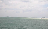
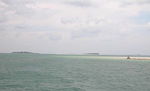
Plymouth Bay is dominated by geographical features such as Plymouth Beach
, a three mile barrier beach that protects Plymouth Harbor
from the rougher seas of Cape Cod Bay
. To the north, Saquish Neck serves as another barrier beach protecting the bay and is almost seven miles in length. Plymouth Beach and Saquish Neck together form a mile wide opening, connecting the bay to the open sea, with boating channels deep enough to sustain moderate boating traffic.
Within Plymouth Bay itself there are considered two smaller bays, Kingston Bay and Duxbury Bay, both in the northern waters of Plymouth Bay, and Warren Cove
, in the southern waters of Plymouth Bay, located between Plymouth Beach and Rocky Point
.
Several peninsulas define the shoreline of Plymouth Bay such as Rocky Nook, a densely populated coastal area of Kingston, and Powder Point of Duxbury. Plymouth Bay contains one island with year-round inhabitants, Clarks Island
, in the northern portion of the bay and is administered by Plymouth. Plymouth Bay also acts as the mouth for several important rivers in the region such as the Jones River
in Kingston and the Eel River
in Plymouth.
Although used for boating, Plymouth Bay itself is relatively shallow. Depths in the bay will range from 35 feet, in the deepest channels west of Fort Standish, to 6 to 42 inches throughout much of the bay's rolling mud flats.
Most of Plymouth Bay's mud flats can be found in Kingston Bay and Duxbury Bay, which are prone to becoming totally exposed in times of low tide. The largest of these such flats is Ichabod's Flat in Kingston Bay. The mud flats of Kingston Bay are used for shellfishing and clamming and have flourished due to Plymouth Bay's ability to isolate itself from red tide
, which occasionally impacts the Massachusetts coastline.
Atlantic Ocean
The Atlantic Ocean is the second-largest of the world's oceanic divisions. With a total area of about , it covers approximately 20% of the Earth's surface and about 26% of its water surface area...
on the western shore of larger Cape Cod Bay
Cape Cod Bay
Cape Cod Bay is a large bay of the Atlantic Ocean adjacent to the U.S. state of Massachusetts. Measuring below a line drawn from Brant Rock in Marshfield to Race Point in Provincetown, Massachusetts, it is enclosed by Cape Cod to the south and east, and Plymouth County, Massachusetts, to the west....
along the coastline of the Commonwealth of Massachusetts. Plymouth Bay retains historical significance for the landing at Plymouth Rock
Plymouth Rock
Plymouth Rock is the traditional site of disembarkation of William Bradford and the Mayflower Pilgrims who founded Plymouth Colony in 1620. It is an important symbol in American history...
in 1620 by the Pilgrims aboard the Mayflower
Mayflower
The Mayflower was the ship that transported the English Separatists, better known as the Pilgrims, from a site near the Mayflower Steps in Plymouth, England, to Plymouth, Massachusetts, , in 1620...
who proceeded to establish the first permanent Northern European settlement in North America
North America
North America is a continent wholly within the Northern Hemisphere and almost wholly within the Western Hemisphere. It is also considered a northern subcontinent of the Americas...
at Plimouth Plantation.
Geography
Plymouth Bay is an offshoot of the larger Cape Cod BayCape Cod Bay
Cape Cod Bay is a large bay of the Atlantic Ocean adjacent to the U.S. state of Massachusetts. Measuring below a line drawn from Brant Rock in Marshfield to Race Point in Provincetown, Massachusetts, it is enclosed by Cape Cod to the south and east, and Plymouth County, Massachusetts, to the west....
and is sometimes considered part of Massachusetts Bay
Massachusetts Bay
The Massachusetts Bay, also called Mass Bay, is one of the largest bays of the Atlantic Ocean which forms the distinctive shape of the coastline of the U.S. state of Massachusetts. Its waters extend 65 miles into the Atlantic Ocean. Massachusetts Bay includes the Boston Harbor, Dorchester Bay,...
, which is defined by Cape Ann
Cape Ann
Cape Ann is a rocky cape in northeastern Massachusetts on the Atlantic Ocean. The cape is located approximately 30 miles northeast of Boston and forms the northern edge of Massachusetts Bay. Cape Ann includes the city of Gloucester, and the towns of Essex, Manchester-by-the-Sea, and...
to the north and Cape Cod
Cape Cod
Cape Cod, often referred to locally as simply the Cape, is a cape in the easternmost portion of the state of Massachusetts, in the Northeastern United States...
to the south. Plymouth Bay is also in the southern waters of the Gulf of Maine
Gulf of Maine
The Gulf of Maine is a large gulf of the Atlantic Ocean on the east coast of North America.It is delineated by Cape Cod at the eastern tip of Massachusetts in the southwest and Cape Sable at the southern tip of Nova Scotia in the northeast. It includes the entire coastlines of the U.S...
in the northern Atlantic Ocean
Atlantic Ocean
The Atlantic Ocean is the second-largest of the world's oceanic divisions. With a total area of about , it covers approximately 20% of the Earth's surface and about 26% of its water surface area...
. The waters of Plymouth Bay are claimed by three Massachusetts towns, Plymouth in the southern part of the bay, Duxbury in the northern part and Kingston
Kingston, Massachusetts
Kingston is a coastal town in Plymouth County, Massachusetts, United States. According to the 2010 Census, it had a population of 12,629.-History:Before European settlers arrived in Kingston it was within the tribal home to the Wampanoag people...
in the westernmost extent of the bay.
Plymouth Bay is dominated by geographical features such as Plymouth Beach
Plymouth Beach, Massachusetts
Plymouth Beach is a small village located in Plymouth, Massachusetts, United States. It is located directly south of Plymouth Center, and is adjacent to Plimoth Plantation...
, a three mile barrier beach that protects Plymouth Harbor
Plymouth Harbor
Plymouth Harbor is the name of a harbor located in Plymouth, Massachusetts, a town in the South Shore region of the state. It is part of the larger Plymouth Bay. Historically, Plymouth Harbor was the site of anchorage of the Mayflower where the Pilgrims offloaded to establish a permanent...
from the rougher seas of Cape Cod Bay
Cape Cod Bay
Cape Cod Bay is a large bay of the Atlantic Ocean adjacent to the U.S. state of Massachusetts. Measuring below a line drawn from Brant Rock in Marshfield to Race Point in Provincetown, Massachusetts, it is enclosed by Cape Cod to the south and east, and Plymouth County, Massachusetts, to the west....
. To the north, Saquish Neck serves as another barrier beach protecting the bay and is almost seven miles in length. Plymouth Beach and Saquish Neck together form a mile wide opening, connecting the bay to the open sea, with boating channels deep enough to sustain moderate boating traffic.
Within Plymouth Bay itself there are considered two smaller bays, Kingston Bay and Duxbury Bay, both in the northern waters of Plymouth Bay, and Warren Cove
Warren Cove (Massachusetts)
Warren Cove is an exclusive oceanfront residential area Plymouth Bay in Plymouth, Massachusetts. Plymouth Beach and Rocky Point surround the southern edge of the cove. Stately homes along Warren Avenue have a commanding view of [Plymouth Long Beach],[Gurnet Light], [Duxbury] Bay, "Bug Light",...
, in the southern waters of Plymouth Bay, located between Plymouth Beach and Rocky Point
Rocky Point (Massachusetts)
Rocky Point is a peninsula in Plymouth, Massachusetts. The peninsula runs along Warren Cove and Plymouth Bay. The tip of the peninsula marks the convergence of Plymouth Bay and the larger Cape Cod Bay...
.
Several peninsulas define the shoreline of Plymouth Bay such as Rocky Nook, a densely populated coastal area of Kingston, and Powder Point of Duxbury. Plymouth Bay contains one island with year-round inhabitants, Clarks Island
Clark's Island
Clark's Island is the name of a small island located in Plymouth Bay in the U.S. state of Massachusetts. It was named for the first mate of the Mayflower, the ship that brought the Pilgrims to New England. The first mate was Richard Clarke, though the island should actually be spelled Clarke's...
, in the northern portion of the bay and is administered by Plymouth. Plymouth Bay also acts as the mouth for several important rivers in the region such as the Jones River
Jones River
The Jones River is a river running through Kingston, Massachusetts. The river drains about , has its source in Silver Lake and drains into Kingston Bay. Land surrounding the river is 52% forested, of which 22% has been developed for residential use...
in Kingston and the Eel River
Eel River (Massachusetts)
The Eel River is a river mostly in the village of Chiltonville in Plymouth, Massachusetts. Its headwaters are springs and small ponds above Russell Millpond. Its watershed encompasses approximately...
in Plymouth.
Although used for boating, Plymouth Bay itself is relatively shallow. Depths in the bay will range from 35 feet, in the deepest channels west of Fort Standish, to 6 to 42 inches throughout much of the bay's rolling mud flats.
Most of Plymouth Bay's mud flats can be found in Kingston Bay and Duxbury Bay, which are prone to becoming totally exposed in times of low tide. The largest of these such flats is Ichabod's Flat in Kingston Bay. The mud flats of Kingston Bay are used for shellfishing and clamming and have flourished due to Plymouth Bay's ability to isolate itself from red tide
Red tide
Red tide is a common name for a phenomenon also known as an algal bloom , an event in which estuarine, marine, or fresh water algae accumulate rapidly in the water column and results in discoloration of the surface water. It is usually found in coastal areas...
, which occasionally impacts the Massachusetts coastline.