

Places inhabited by Rusyns
Encyclopedia
The contemporary administrative entities roughly corresponding the traditional territory of settlement of the Rusyns
. Following areas have been included which still are or up to the World War II
were inhabited by each of the Rusyn sub-ethnicities mentioned below:
Dolinyans:
Boyko
s:
Hutsuls:
Lemkos:
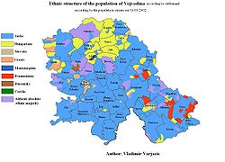
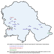 There are Pannonian Rusyns
, too, in Serbia
(most notably in Vojvodina
), and in Bosnia and Herzegovina
, Croatia
and Hungary
.
For the Rusyn diaspora see the Wikipedia articles Rusyns
and Rusyn American
. Also see the article Gorals
for a group of related Carpathian
microethnoses.
Rusyns
Carpatho-Rusyns are a primarily diasporic ethnic group who speak an Eastern Slavic language, or Ukrainian dialect, known as Rusyn. Carpatho-Rusyns descend from a minority of Ruthenians who did not adopt the use of the ethnonym "Ukrainian" in the early twentieth century...
. Following areas have been included which still are or up to the World War II
World War II
World War II, or the Second World War , was a global conflict lasting from 1939 to 1945, involving most of the world's nations—including all of the great powers—eventually forming two opposing military alliances: the Allies and the Axis...
were inhabited by each of the Rusyn sub-ethnicities mentioned below:
Dolinyans:
- UkraineUkraineUkraine is a country in Eastern Europe. It has an area of 603,628 km², making it the second largest contiguous country on the European continent, after Russia...
: Zakarpattia OblastZakarpattia OblastThe Zakarpattia Oblast is an administrative oblast located in southwestern Ukraine. Its administrative center is the city of Uzhhorod...
excluding Rakhivskyi Raion, see Hutsuls;
Boyko
Boyko
Boyko or Boiko are a distinctive group of Ukrainian highlanders or mountain-dwellers of the Carpathian highlands. The Boykos inhabited the central and the western half of the Carpathians in Ukraine, including the Dolynskyi and a part of the Rozhniativskyi Raions in the Ivano-Frankivsk Oblast ,...
s:
- PolandPolandPoland , officially the Republic of Poland , is a country in Central Europe bordered by Germany to the west; the Czech Republic and Slovakia to the south; Ukraine, Belarus and Lithuania to the east; and the Baltic Sea and Kaliningrad Oblast, a Russian exclave, to the north...
: Subcarpathian Voivodship: Bieszczady CountyBieszczady CountyBieszczady County is a unit of territorial administration and local government in Subcarpathian Voivodeship, in the extreme south-east of Poland, on the border with Ukraine. It takes its name from the Bieszczady mountain range. The county was created on January 1, 1999, as a result of the Polish...
, Lesko CountyLesko CountyLesko County is a unit of territorial administration and local government in Subcarpathian Voivodeship, south-eastern Poland, on the Slovak border. It was created in 2002 out of five gminas which previously made up the western part of Bieszczady County...
; also see the Wikipedia article Operation Vistula;
- Ukraine: Ivano-Frankivsk OblastIvano-Frankivsk OblastIvano-Frankivsk Oblast is an oblast in western Ukraine. Its administrative center is the city of Ivano-Frankivsk. As is the case with most other oblasts of Ukraine this region has the same name as its administrative center – which was renamed by the Soviets after the Ukrainian writer, nationalist...
: Bohorodchanskyi RaionBohorodchanskyi RaionThe Bohorodchany raion is a district of the Ivano-Frankivsk Region in Ukraine. A town of Bohorodchany is the administrative center of the district.-Geography:...
, Bolekhiv CityBolekhivBolekhiv is a city in Ivano-Frankivsk Oblast of Ukraine. It is designated into a self-administrated city district of oblast subordination...
, Dolynskyi RaionDolynskyi Raion (Ivano-Frankivsk Oblast)Dolyna Raion is a raion of the Ivano-Frankivsk Oblast of Ukraine. The city of Dolyna is the administrative center of the raion.-External links:...
, Rozhniativskyi RaionRozhniativskyi RaionThe Rozhniativ Raion is a raion of the Ivano-Frankivsk Oblast . Rozhniativ is the administrative center of the raion.-Settlements:The region does not have cities, however there are several towns.*Broshniv-Osada...
; Lviv OblastLviv OblastLviv Oblast is an oblast in western Ukraine. The administrative center of the oblast is the city of Lviv.-History:The oblast was created as part of the Ukrainian Soviet Socialist Republic on December 4, 1939...
: Starosambirskyi RaionStaryi SambirStaryi Sambir is a city in the Lviv Oblast of western Ukraine, close to the border with Poland. It is the administrative center of the Starosambirskyi Raion , and is located at around .The current estimated population is around 5,700 ....
, Skolivskyi RaionSkolethumb|right|200px|A church in SkoleSkole is a city in the Lviv Oblast of Ukraine. It is administrative center of the Skole Raion. As of 2001, the population is 6,742.- History :...
, Turkivskyi Raion;
Hutsuls:
- RomaniaRomaniaRomania is a country located at the crossroads of Central and Southeastern Europe, on the Lower Danube, within and outside the Carpathian arch, bordering on the Black Sea...
: Maramureş CountyMaramures CountyMaramureș is a county of Romania, in the Maramureș region. The county seat is Baia Mare.- History :* The 10th century frontier county of Borsova was founded by Stephen I of Hungary. Since then Máramaros served as the north-eastern border of the Hungarian Kingdom until 1920, the Trianon Peace...
, Suceava CountySuceava CountySuceava is a county of Romania, in the historical region of Moldavia and few villages in Transylvania, with the capital city at Suceava.- Demographics :...
;
- Ukraine: Chernivtsi OblastChernivtsi OblastChernivtsi Oblast is an oblast in western Ukraine, bordering on Romania and Moldova. It has a large variety of landforms: the Carpathian Mountains and picturesque hills at the foot of the mountains gradually change to a broad partly forested plain situated between the Dniester and Prut rivers....
: Hlybotskyi RaionHlybotskyi RaionHlyboka Raion is an administrative district of Chernivtsi Oblast in western Ukraine. The population of the raion as of 2001 is 72,682 inhabitants , its area covers 686 km2. The administrative center is the town of Hlyboka. There are 37 villages in the raion.In Hlybotskyi Raion there are 46...
, Putylskyi RaionChernivtsi OblastChernivtsi Oblast is an oblast in western Ukraine, bordering on Romania and Moldova. It has a large variety of landforms: the Carpathian Mountains and picturesque hills at the foot of the mountains gradually change to a broad partly forested plain situated between the Dniester and Prut rivers....
, Storozhynetskyi RaionStorozhynetskyi RaionStorozhynets Raion is a raion in Chernivtsi Oblast, in the southwest of Ukraine, administrative center is Storozhynets. It borders with Romania from south, Vyzhnytsia Raion from west, Kitsman Raion from north, municipality of Chernivtsi and Hlyboka Raion from east.According to the 2001 Ukrainian...
, Vyzhnytskyi RaionVyzhnytsiaVyzhnytsia is a town located on the Cheremosh River in the Chernivtsi Oblast of western Ukraine. It is the administrative center of Vyzhnytsia Raion.-Notable People from Vyzhnytsia:* Gerard Ciołek, architect* Menachem Mendel Hager, first Vizhnitser Rebbe...
; Ivano-Frankivsk OblastIvano-Frankivsk OblastIvano-Frankivsk Oblast is an oblast in western Ukraine. Its administrative center is the city of Ivano-Frankivsk. As is the case with most other oblasts of Ukraine this region has the same name as its administrative center – which was renamed by the Soviets after the Ukrainian writer, nationalist...
: Kosivskyi RaionKosivskyi RaionKosiv Raion is a raion of the Ivano-Frankivsk Oblast of Ukraine. The city of Kosiv is the administrative center of the raion....
, Nadvirnianskyi RaionNadvirnianskyi RaionThe Nadvirna Raion is a raion of the Ivano-Frankivsk Oblast . Nadvirna is the administrative center of the raion....
, Verkhovynskyi RaionVerkhovynskyi RaionThe Verkhovyna Raion is a raion of the Ivano-Frankivsk Oblast . Verkhovyna is the administrative center of the raion. Part of Verkhovyna is also a village of Vipche....
, Yaremche City; Zakarpattia OblastZakarpattia OblastThe Zakarpattia Oblast is an administrative oblast located in southwestern Ukraine. Its administrative center is the city of Uzhhorod...
: Rakhivskyi RaionRakhivRakhiv is a city located in the Zakarpattia Oblast in western Ukraine. It is the administrative center of the Rakhiv Raion .- Demographics :As of 2001, the city population was 15,241 inhabitants which included: * 83.8% Ukrainians...
;
Lemkos:
- Poland: Lesser Poland VoivodeshipLesser Poland VoivodeshipMałopolska Voivodeship , or Lesser Poland Voivodeship, is a voivodeship, in southern Poland...
: Gorlice CountyGorlice CountyGorlice County is a unit of territorial administration and local government in Lesser Poland Voivodeship, southern Poland, on the Slovak border. It was created on 1 January 1999 as a result of the Polish local government reforms passed in 1998. Its administrative seat and largest town is Gorlice,...
, Nowy Sącz CountyNowy Sacz CountyNowy Sącz County is a unit of territorial administration and local government in Lesser Poland Voivodeship, southern Poland, on the Slovak border. It came into being on January 1, 1999, as a result of the Polish local government reforms passed in 1998...
, Nowy Targ CountyNowy Targ CountyNowy Targ County is a unit of territorial administration and local government in Lesser Poland Voivodeship, southern Poland, on the Slovak border. It came into being on January 1, 1999, as a result of the Polish local government reforms passed in 1998. Its administrative seat and largest town is...
, Tatra CountyTatra CountyTatra County is a unit of territorial administration and local government in Lesser Poland Voivodeship, southern Poland, on the Slovak border. It came into being on January 1, 1999, as a result of the Polish local government reforms passed in 1998. Its administrative seat and only town is...
; Subcarpathian Voivodship: Jasło County, Krosno CountyKrosno CountyKrosno County is a unit of territorial administration and local government in Subcarpathian Voivodeship, south-eastern Poland, on the Slovak border. It came into being on January 1, 1999, as a result of the Polish local government reforms passed in 1998...
, Sanok CountySanok CountySanok County is a unit of territorial administration and local government in Subcarpathian Voivodeship, south-eastern Poland, on the Slovak border. It came into being on January 1, 1999, as a result of the Polish local government reforms passed in 1998. Its administrative seat and largest town is...
; also see the Wikipedia article Operation Vistula;
- SlovakiaSlovakiaThe Slovak Republic is a landlocked state in Central Europe. It has a population of over five million and an area of about . Slovakia is bordered by the Czech Republic and Austria to the west, Poland to the north, Ukraine to the east and Hungary to the south...
: Košice RegionKošice RegionThe Košice Region is one of the eight Slovak administrative regions. It consists of 11 districts .-Geography:It is located in the southern part of eastern Slovakia and covers an area of 6,752 km²...
: Michalovce DistrictMichalovce DistrictMichalovce District is a district inthe Košice Region of eastern Slovakia.Until 1918, the district was split between the Hungarian counties of Zemplín and Uh .-Municipalities:* Bajany...
, Sobrance DistrictSobrance DistrictSobrance District is a district inthe Košice Region of eastern Slovakia.Until 1918, the district was mostly part of the Hungarian county of Ung, apart from the area around the municipalities of...
, Trebišov DistrictTrebišov DistrictTrebišov District is a district inthe Košice Region of eastern Slovakia.Until 1918, the district was mostly part of the Hungarian county of Zemplín, apart from a small area...
; Prešov RegionPrešov RegionThe Prešov Region is one of the eight Slovak administrative regions. It consists of 13 districts.-Geography:It is located in north-eastern Slovakia and has an area of 8,975 km². The region has diverse types of landscapes occurring in Slovakia, but mostly highlands and hilly lands dominate the...
: Bardejov DistrictBardejov DistrictBardejov District is a district in the Prešov Region of eastern Slovakia.Until 1918, the district was part of the Hungarian county of...
, Humenné DistrictHumenné DistrictHumenné District is a district inthe Prešov Region of eastern Slovakia....
, Kežmarok DistrictKežmarok DistrictKežmarok District is a district inthe Prešov Region of eastern Slovakia.Until 1918, the district was almost entirely part of the Hungarian county of Spiš, apart from a small area in the...
, Medzilaborce DistrictMedzilaborce DistrictMedzilaborce District is a district inthe Prešov Region of northeastern Slovakia. It is the least populated of Slovakia's 79 districts...
, Poprad DistrictPoprad DistrictPoprad District is a district inthe Prešov Region of eastern Slovakia.Until 1918, the district was almost entirely part of the Hungarian county of Spiš, apart from two small areas in the...
, Snina DistrictSnina DistrictSnina District is a district inthe Prešov Region of eastern Slovakia.Until 1918, the district was part of the Hungarian county of Zemplín.-Municipalities:*Belá nad Cirochou*Brezovec*Čukalovce*Dlhé nad Cirochou*Dúbrava*Hostovice...
, Stará Ľubovňa DistrictStará Lubovna DistrictStará Ľubovňa District is a district inthe Prešov Region of eastern Slovakia.Until 1918, the district was almost entirely part of the Hungarian county of Spiš, apart from a small area in the...
, Stropkov DistrictStropkov DistrictStropkov District is a district inthe Prešov Region of eastern Slovakia.Until 1918, the district was mostly part of the Hungarian county of Zemplín, apart from an area in the...
, Svidník DistrictSvidník DistrictSvidník District is a district in the Prešov Region of eastern Slovakia. Territory Svidník district and his0 location is near of the Dukla Pass and the Republic of Poland....
; Žilina RegionŽilina RegionThe Žilina Region is one of the eight Slovak administrative regions and consists of 11 districts .-Geography:It is located in northern Slovakia and has an area of 6,804 km² and a population of 694,763 . The whole area is mountainous, belonging to the Western Carpathians...
: Námestovo DistrictNámestovo DistrictNámestovo District is adistrict inthe Žilina Region of central Slovakia.Until 1918, the district was part of theHungarian countyof Orava.- Municipalities :*Babín*Beňadovo*Bobrov*Breza*Hruštín*Klin*Krušetnica*Lokca*Lomná...
, Tvrdošín DistrictTvrdošín DistrictTvrdošín District is a district inthe Žilina Region of central Slovakia.Until 1918, the district was part of the Hungarian county of Orava.- Municipalities :*Brezovica*Čimhová*Habovka*Hladovka*Liesek*Nižná*Oravský Biely Potok...
.
Pannonian Rusyns
Rusyns in Pannonia, or simply Rusyns or Ruthenians , are a Slavic minority in Serbia and Croatia...
, too, in Serbia
Serbia
Serbia , officially the Republic of Serbia , is a landlocked country located at the crossroads of Central and Southeast Europe, covering the southern part of the Carpathian basin and the central part of the Balkans...
(most notably in Vojvodina
Vojvodina
Vojvodina, officially called Autonomous Province of Vojvodina is an autonomous province of Serbia. Its capital and largest city is Novi Sad...
), and in Bosnia and Herzegovina
Bosnia and Herzegovina
Bosnia and Herzegovina , sometimes called Bosnia-Herzegovina or simply Bosnia, is a country in Southern Europe, on the Balkan Peninsula. Bordered by Croatia to the north, west and south, Serbia to the east, and Montenegro to the southeast, Bosnia and Herzegovina is almost landlocked, except for the...
, Croatia
Croatia
Croatia , officially the Republic of Croatia , is a unitary democratic parliamentary republic in Europe at the crossroads of the Mitteleuropa, the Balkans, and the Mediterranean. Its capital and largest city is Zagreb. The country is divided into 20 counties and the city of Zagreb. Croatia covers ...
and Hungary
Hungary
Hungary , officially the Republic of Hungary , is a landlocked country in Central Europe. It is situated in the Carpathian Basin and is bordered by Slovakia to the north, Ukraine and Romania to the east, Serbia and Croatia to the south, Slovenia to the southwest and Austria to the west. The...
.
For the Rusyn diaspora see the Wikipedia articles Rusyns
Rusyns
Carpatho-Rusyns are a primarily diasporic ethnic group who speak an Eastern Slavic language, or Ukrainian dialect, known as Rusyn. Carpatho-Rusyns descend from a minority of Ruthenians who did not adopt the use of the ethnonym "Ukrainian" in the early twentieth century...
and Rusyn American
Rusyn American
Rusyn Americans are Americans whose ancestors were born in Carpathian Ruthenia. Some Rusyn Americans identify as Russian Americans or Ukrainian Americans.-History:...
. Also see the article Gorals
Gorals
The Gorale are a group of indigenous people found along southern Poland, northern Slovakia, and in the region of Cieszyn Silesia in the Czech Republic...
for a group of related Carpathian
Carpathian Mountains
The Carpathian Mountains or Carpathians are a range of mountains forming an arc roughly long across Central and Eastern Europe, making them the second-longest mountain range in Europe...
microethnoses.