

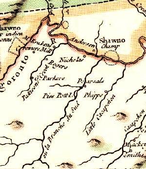
Piss Pot Island
Encyclopedia
Island
An island or isle is any piece of sub-continental land that is surrounded by water. Very small islands such as emergent land features on atolls can be called islets, cays or keys. An island in a river or lake may be called an eyot , or holm...
on the South Branch Potomac River west of Romney
Romney, West Virginia
Romney is a city in and the county seat of Hampshire County, West Virginia, United States. The population was 1,940 at the 2000 census, while the area covered by the city's ZIP code had a population of 5,873. It is a city with a very historic background dating back to the 18th century...
in Hampshire County
Hampshire County, West Virginia
Hampshire County is a county located in the U.S. state of West Virginia. As of 2010, the population was 23,964. Its county seat is Romney, West Virginia's oldest town . Hampshire County was created by the Virginia General Assembly on December 13, 1753, from parts of Frederick and Augusta counties ...
, West Virginia
West Virginia
West Virginia is a state in the Appalachian and Southeastern regions of the United States, bordered by Virginia to the southeast, Kentucky to the southwest, Ohio to the northwest, Pennsylvania to the northeast and Maryland to the east...
. Piss Pot Island received its unflattering name before 1755, the year it was included on Joshua Fry and Peter Jefferson
Peter Jefferson
Peter Jefferson was the father of American President Thomas Jefferson . A surveyor and cartographer, his Fry-Jefferson Map of 1751 accurately depicted the Allegheny Mountains for the first time and showed the route of "The Great Road from the Yadkin River thro Virginia to Philadelphia distant 455...
's Carte de la Virginie et du Maryland. Uncommon for islands of its size and geologic nature, Piss Pot Island has remained approximately the same size since the eighteenth century. The island is forested primarily with American sycamore
American sycamore
Platanus occidentalis, also known as American Sycamore, American plane, Occidental plane, and Buttonwood, is one of the species of Platanus native to North America...
s and silver maple
Silver Maple
The silver maple —also called creek maple, river maple, silverleaf maple, soft maple, water maple, or white maple—is a species of maple native to eastern North America in the eastern United States and Canada...
s. It continues to be popular with fishermen and canoers
Canoe
A canoe or Canadian canoe is a small narrow boat, typically human-powered, though it may also be powered by sails or small electric or gas motors. Canoes are usually pointed at both bow and stern and are normally open on top, but can be decked over A canoe (North American English) or Canadian...
on the South Branch Potomac River. Mill Creek empties into the South Branch to its western shore and Wergman Run enters the river to its northeast.
Piss Pot Island is currently owned by the Williams family of Sycamore Dale
Sycamore Dale
Sycamore Dale is a 19th-century Greek Revival plantation home overlooking the South Branch Potomac River southwest of Romney, West Virginia. Sycamore Dale is one of several historic estates along South Branch River Road...
, the historic brick plantation
Plantation
A plantation is a long artificially established forest, farm or estate, where crops are grown for sale, often in distant markets rather than for local on-site consumption...
house located to its east on South Branch River Road (County Route
County highway
A county highway is a road in the United States and in the Canadian province of Ontario that is designated and/or maintained by the county highway department...
8). It is easily viewed from the Northwestern Turnpike
Northwestern Turnpike
The Northwestern Turnpike is a historic road in West Virginia , important for being historically one of the major roads crossing the Appalachians, financed by the Virginia Board of Public Works in the 1830s. In modern times, west of Winchester, Virginia, U.S...
(U.S. Route 50
U.S. Route 50
U.S. Route 50 is a major east–west route of the U.S. Highway system, stretching just over from Ocean City, Maryland on the Atlantic Ocean to West Sacramento, California. Until 1972, when it was replaced by Interstate Highways west of the Sacramento area, it extended to San Francisco, near...
) in Vanderlip
Vanderlip, West Virginia
Vanderlip is an unincorporated community in Hampshire County in the U.S. state of West Virginia. Vanderlip is located west of Romney along the Northwestern Turnpike and the South Branch Valley Railroad. At times the community was referred to as West Romney Station, while its post office used the...
and the Romney Bridge.