
Pennsylvania Route 588
Encyclopedia
Pennsylvania Route 588 is an east–west state highway in the Western Pennsylvania
counties of Beaver
and Butler
. It travels sixteen miles between PA 51
in Chippewa Township, Beaver County
and PA 288 in Zelienople
. Other communities through which it passes include the city of Beaver Falls
and the borough of Eastvale
.
 PA 588 begins at an intersection with PA 51
in Chippewa Township
, Beaver County
, heading southeast on two-lane undivided Darlington Road. The road briefly runs to the northeast of PA 51 before turning east into residential areas, passing over I-376
. The route heads southeast through more neighborhoods before turning northeast onto Steffin Hill Road and crossing into White Township
. PA 588 passes through Steffens Hill and runs east through wooded areas near White Township Park. The road passes a few homes before passing under a Norfolk Southern railroad line, at which point it heads into Beaver Falls
. The route turns southeast onto 24th Street, curving east into commercial areas. PA 588 intersects PA 18
and turns north to form a concurrency
with that route on 7th Avenue, a two-lane divided highway
that passes homes. PA 588 splits from PA 18 by turning east onto four-lane divided 4th Street. The route comes to the Eastvale Bridge
which carries it over a CSX railroad line before crossing the Beaver River
into Eastvale
and passing over a Norfolk Southern railroad line. PA 588 turns north onto two-lane undivided 2nd Avenue East and passes several homes. The road heads into North Sewickley Township
and becomes Bennetts Run Road, heading into forested areas and turning east. The route heads through more wooded areas with some residences and turns to the northeast.
PA 588 turns east and crosses PA 65
, at which point it becomes Concord Church Road and passes through a mix of farmland and woodland with some homes. The route passes under I-76
(Pennsylvania Turnpike
) and heads into open agricultural areas with occasional residences. The road heads to the southeast and runs between farms to the north and woods to the south before continuing into forests. PA 588 heads east into a mix of farms and woods, crossing into Marion Township
and becoming an unnamed road that passes through Barrisville. The route curves to the northeast and enters open agricultural areas, curving to the northwest before a turn to the north. PA 588 continues into areas of farms and woods with some homes, turning to the east. The road continues through rural areas with some development, curving southeast as it heads into more wooded surroundings and runs to the south of Connoquenessing Creek
, heading east again. The route runs near homes and industrial areas before coming to a bridge over a Buffalo and Pittsburgh Railroad
line and the Connoquenessing Creek, at which point it continues into Franklin Township
. At this point, PA 588 passes between the Zelienople Municipal Airport
to the north and industry to the south. The route enters Zelienople
in Butler County
and comes to an intersection with PA 288
, at which point PA 588 signage ends. At this point, PA 588 becomes an unsigned highway
that follows PA 288 east along West New Castle Street. The road crosses Connoquenessing Creek again and heads into industrial areas, crossing a Buffalo and Pittsburgh Railroad line. PA 288/PA 588 continues east through residential areas to its eastern terminus at US 19
/PA 68
in the commercial downtown of Zelienople.
Western Pennsylvania
Western Pennsylvania consists of the western third of the state of Pennsylvania in the United States. Pittsburgh is the largest city in the region, with a metropolitan area population of about 2.4 million people, and serves as its economic and cultural center. Erie, Altoona, and Johnstown are its...
counties of Beaver
Beaver County, Pennsylvania
-Demographics:As of the census of 2000, there were 181,412 people, 72,576 households, and 50,512 families residing in the county. The population density was 418 people per square mile . There were 77,765 housing units at an average density of 179 per square mile...
and Butler
Butler County, Ohio
Butler County is a county located in the state of Ohio, United States. As of 2010, the population was 368,130. Its county seat is Hamilton. It is named for General Richard Butler, who died in 1791 fighting Indians in northern Ohio. Butler's army marched out of Fort Hamilton, where the city of...
. It travels sixteen miles between PA 51
Pennsylvania Route 51
Pennsylvania Route 51 is a major state highway in Western Pennsylvania. It runs for from Uniontown to the Ohio state line near Darlington, where it connects with Ohio State Route 14. Route 51 is the termination point for Pennsylvania Route 43, Pennsylvania Route 48 and Pennsylvania Route 88. ...
in Chippewa Township, Beaver County
Chippewa Township, Pennsylvania
Chippewa Township is a township in Beaver County, Pennsylvania, United States. The population was 7,021 at the 2000 census.-Geography:According to the United States Census Bureau, the township has a total area of , all of it land.-Demographics:...
and PA 288 in Zelienople
Zelienople, Pennsylvania
Zelienople is a borough in Butler County, Pennsylvania, north of Pittsburgh. The population was 4,123 at the 2000 census.-Geography:According to the United States Census Bureau, the borough has a total area of , of which 98% is land and 1.35% is water....
. Other communities through which it passes include the city of Beaver Falls
Beaver Falls, Pennsylvania
Beaver Falls is a city in Beaver County, Pennsylvania, United States. The population was 8,987 at the 2010 census. It is located 31 miles northwest of Pittsburgh, and on the Beaver River, six miles from its confluence with the Ohio River...
and the borough of Eastvale
Eastvale, Pennsylvania
Eastvale is a borough in Beaver County, Pennsylvania, United States. The population was 293 at the 2000 census.-History:Originally known as "Fetterman," Eastvale was incorporated from parts of North Sewickley and Pulaski townships on July 1, 1892. The population was 256 at the 1900 census, the...
.
Route description
Pennsylvania Route 51
Pennsylvania Route 51 is a major state highway in Western Pennsylvania. It runs for from Uniontown to the Ohio state line near Darlington, where it connects with Ohio State Route 14. Route 51 is the termination point for Pennsylvania Route 43, Pennsylvania Route 48 and Pennsylvania Route 88. ...
in Chippewa Township
Chippewa Township, Pennsylvania
Chippewa Township is a township in Beaver County, Pennsylvania, United States. The population was 7,021 at the 2000 census.-Geography:According to the United States Census Bureau, the township has a total area of , all of it land.-Demographics:...
, Beaver County
Beaver County, Pennsylvania
-Demographics:As of the census of 2000, there were 181,412 people, 72,576 households, and 50,512 families residing in the county. The population density was 418 people per square mile . There were 77,765 housing units at an average density of 179 per square mile...
, heading southeast on two-lane undivided Darlington Road. The road briefly runs to the northeast of PA 51 before turning east into residential areas, passing over I-376
Interstate 376
Interstate 376 is a major auxiliary route of the Interstate Highway System in the U.S. state of Pennsylvania, located entirely within the Allegheny Plateau. It runs from I-80 near Sharon south and east to a junction with the Pennsylvania Turnpike in Monroeville, after having crossed the Turnpike...
. The route heads southeast through more neighborhoods before turning northeast onto Steffin Hill Road and crossing into White Township
White Township, Beaver County, Pennsylvania
White Township is a township in Beaver County, Pennsylvania, United States. The population was 1,434 at the 2000 census.-Geography:According to the United States Census Bureau, the township has a total area of 0.7 square miles , all of it land.-Demographics:As of the census of 2000, there were...
. PA 588 passes through Steffens Hill and runs east through wooded areas near White Township Park. The road passes a few homes before passing under a Norfolk Southern railroad line, at which point it heads into Beaver Falls
Beaver Falls, Pennsylvania
Beaver Falls is a city in Beaver County, Pennsylvania, United States. The population was 8,987 at the 2010 census. It is located 31 miles northwest of Pittsburgh, and on the Beaver River, six miles from its confluence with the Ohio River...
. The route turns southeast onto 24th Street, curving east into commercial areas. PA 588 intersects PA 18
Pennsylvania Route 18
Pennsylvania Route 18 is a major north–south highway in Western Pennsylvania whose southern terminus is at the West Virginia state line in Greene County, Pennsylvania near the village of Garrison, while the northern terminus is at PA Route 5 in Lake City, Pennsylvania...
and turns north to form a concurrency
Concurrency (road)
A concurrency, overlap, or coincidence in a road network is an instance of one physical road bearing two or more different highway, motorway, or other route numbers...
with that route on 7th Avenue, a two-lane divided highway
Divided Highway
Divided Highway is a compilation album by American rock band The Doobie Brothers, released in 2003. . All tracks are taken from the albums Cycles and Brotherhood .-Track listing:...
that passes homes. PA 588 splits from PA 18 by turning east onto four-lane divided 4th Street. The route comes to the Eastvale Bridge
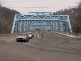
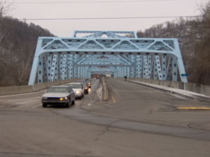
Eastvale Bridge
The Eastvale Bridge is a bridge that carries PA Route 588 over the Beaver River between the borough of Eastvale, and the city of Beaver Falls, Pennsylvania. The bridge opened in Beaver County on November 22, 1963, the day President John F. Kennedy was assassinated. The bridge was named in his honor...
which carries it over a CSX railroad line before crossing the Beaver River
Beaver River (Pennsylvania)
The Beaver River is a tributary of the Ohio River in Western Pennsylvania in the United States with a length of approximately 21 mi . It flows through a historically important coal-producing region north of Pittsburgh...
into Eastvale
Eastvale, Pennsylvania
Eastvale is a borough in Beaver County, Pennsylvania, United States. The population was 293 at the 2000 census.-History:Originally known as "Fetterman," Eastvale was incorporated from parts of North Sewickley and Pulaski townships on July 1, 1892. The population was 256 at the 1900 census, the...
and passing over a Norfolk Southern railroad line. PA 588 turns north onto two-lane undivided 2nd Avenue East and passes several homes. The road heads into North Sewickley Township
North Sewickley Township, Pennsylvania
North Sewickley Township is a township in Beaver County, Pennsylvania, United States. The population was 6,120 at the 2000 census.-Geography:...
and becomes Bennetts Run Road, heading into forested areas and turning east. The route heads through more wooded areas with some residences and turns to the northeast.
PA 588 turns east and crosses PA 65
Pennsylvania Route 65
Pennsylvania Route 65 is a major state highway located in western Pennsylvania, United States. The route, traveling north–south from the Interstate 279/U.S...
, at which point it becomes Concord Church Road and passes through a mix of farmland and woodland with some homes. The route passes under I-76
Interstate 76 (east)
Interstate 76 is an Interstate Highway in the United States, running 435 miles from an interchange with Interstate 71 west of Akron, Ohio, east to Interstate 295 near Camden, New Jersey....
(Pennsylvania Turnpike
Pennsylvania Turnpike
The Pennsylvania Turnpike is a toll highway system operated by the Pennsylvania Turnpike Commission in the Commonwealth of Pennsylvania, United States. The three sections of the turnpike system total . The main section extends from Ohio to New Jersey and is long...
) and heads into open agricultural areas with occasional residences. The road heads to the southeast and runs between farms to the north and woods to the south before continuing into forests. PA 588 heads east into a mix of farms and woods, crossing into Marion Township
Marion Township, Beaver County, Pennsylvania
Marion Township is a township in Beaver County, Pennsylvania, United States. The population was 940 at the 2000 census.-Geography:According to the United States Census Bureau, the township has a total area of 10.5 square miles , of which, 10.3 square miles of it is land and...
and becoming an unnamed road that passes through Barrisville. The route curves to the northeast and enters open agricultural areas, curving to the northwest before a turn to the north. PA 588 continues into areas of farms and woods with some homes, turning to the east. The road continues through rural areas with some development, curving southeast as it heads into more wooded surroundings and runs to the south of Connoquenessing Creek
Connoquenessing Creek
Connoquenessing Creek is a tributary of the Beaver River, approximately 50 mi long, in Western Pennsylvania in the United States.-Course:...
, heading east again. The route runs near homes and industrial areas before coming to a bridge over a Buffalo and Pittsburgh Railroad
Buffalo and Pittsburgh Railroad
The Buffalo and Pittsburgh Railroad is a Class II railroad operating in New York and Pennsylvania.The BPRR is owned by Genesee and Wyoming Industries. Its main line runs between Buffalo, New York and Eidenau, Pennsylvania, north of Pittsburgh. Here, connections are made to the city center via the...
line and the Connoquenessing Creek, at which point it continues into Franklin Township
Franklin Township, Beaver County, Pennsylvania
Franklin Township is a township in Beaver County, Pennsylvania, United States. The population was 4,307 at the 2000 census.-Geography:According to the United States Census Bureau, the township has a total area of , of which, of it is land and of it is water.-Demographics:As of the census of...
. At this point, PA 588 passes between the Zelienople Municipal Airport
Zelienople Municipal Airport
Zelienople Airport , is a public airport located 1 mile west of Zelienople, Pennsylvania, USA. Though it primarily serves the community of Zelienople , the airport is actually located over the county line in neighboring Beaver County. The Zelienople Municipal Airport is located in Fombell, PA...
to the north and industry to the south. The route enters Zelienople
Zelienople, Pennsylvania
Zelienople is a borough in Butler County, Pennsylvania, north of Pittsburgh. The population was 4,123 at the 2000 census.-Geography:According to the United States Census Bureau, the borough has a total area of , of which 98% is land and 1.35% is water....
in Butler County
Butler County, Pennsylvania
-Demographics:As of the census of 2000, there were 174,083 people, 65,862 households, and 46,827 families residing in the county. The population density was 221 people per square mile . There were 69,868 housing units at an average density of 89 per square mile...
and comes to an intersection with PA 288
Pennsylvania Route 288
Pennsylvania Route 288 or State Route 288 is an east–west route in western Pennsylvania, United States. The highway is 15.4 miles long from PA Route 18 in Wampum to the U.S...
, at which point PA 588 signage ends. At this point, PA 588 becomes an unsigned highway
Unsigned highway
An unsigned highway is a highway that has been assigned a route number, but does not bear conventional road markings that would normally be used to identify the route with that number...
that follows PA 288 east along West New Castle Street. The road crosses Connoquenessing Creek again and heads into industrial areas, crossing a Buffalo and Pittsburgh Railroad line. PA 288/PA 588 continues east through residential areas to its eastern terminus at US 19
U.S. Route 19 in Pennsylvania
U.S. Route 19 in Pennsylvania closely parallels Interstate 79 for its entire length. US 19 enters Pennsylvania in Greene County near Mount Morris. Its northern terminus is in the city of Erie. Part is named for Commodore Oliver Hazard Perry, hero of the Battle of Lake Erie.-Route description:In...
/PA 68
Pennsylvania Route 68
Pennsylvania Route 68 is a long east–west state highway located in western Pennsylvania in the United States. The western terminus of the route is at the Ohio state line west of Glasgow, where PA 68 continues into Ohio as State Route 39. The eastern terminus is at U.S...
in the commercial downtown of Zelienople.