
Parkways of Louisville, Kentucky
Encyclopedia
The parkway system of Louisville, Kentucky
, also known as the Olmsted Park System, was designed by the firm of preeminent 19th century landscape architect Frederick Law Olmsted
. The 26 miles (41.8 km) system was built from the early 1890s through the 1930s, and initially owned by a state-level parks commission, which passed control to the city of Louisville in 1942.
The system was intended to form a circuit around what was then the fringes of the city of Louisville. However, there is a disconnect of several blocks between Eastern and Southern Parkways, and most glaringly, a planned parkway running from the terminus of Western (today's Northwestern) Parkway along the Ohio River
and around to Eastern Parkway was never built.
Today, the system falls under direct management of the Louisville Olmsted Parks Conservancy, and under broader supervision by Louisville's Metro Parks Department
purchased what became Iroquois Park
a year later and quickly began acquiring through donations the land to build 150 feet (45.7 m)-wide "Grand Boulevard" (later renamed Southern Parkway) connecting that southern property to the city. Jacob claimed the boulevard would rival Champs-Élysées
in Paris.
A parks commission was created in 1890, and soon hired Olmsted's firm to design the entire system. The firm delivered a report in September 1891 calling for three large parks and parkways connecting them.
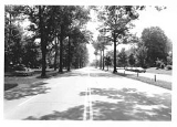
The parkways were intended to carry light pleasure vehicles between the parks, with no access to heavier commercial vehicles. It was not until 1958 that the city opened up the parkways to all commercial and passenger traffic. As the city expanded and the parkways became heavily traveled roads, they have been widened beyond their original two lanes, in many cases sacrificing the grass medians and tree-lined yards that were originally a part of them. Still, as of 2000, 75% of the original trees remained or had been replaced by new trees. There were 5,107 trees along the parkways according to a 1994 count. Between 2008 and 2011, a major project was undertaken to restore many of the trees that had been damaged by storms, traffic, or age and disease. This has filled in many of the canopy gaps along the parkways, and was done as much as possible in accordance with the original Olmstedian plan. Today there are various proposals being debated to ease traffic issues and restore connectivity of the city's parks via these routes. One such plan involves bike lanes and center lanes for turning.
.
Algonquin has been cited as the "most extreme" example of a parkway that has deviated from the original plan, due to a junkyard that is located alongside it.
. This portion ends a few blocks from Southern Parkway, and is a key gap between the parkways that has never been filled in. The portion through the University of Louisville campus was initially just two lanes, creating a major traffic bottleneck. This portion was replaced with a viaduct which passes over the campus, completed in October 1954 at a cost of $850,000. The viaduct was opened with a ribbon-cutting ceremony attended by mayor Broaddus, who then got into his car to become the first to drive over it. However, two vehicles competing to be the second collided, creating a wreck within seconds of the road's opening.
East of the University, there is an interchange with Interstate 65
, and past that the parkway takes on a more residential feel for the rest of the route, with houses and apartment buildings on either side, except for near major intersections. The parkway passes over a concrete channel Beargrass Creek
on an overpass built in 1961.
From Barrett to Baxter Avenue, the parkway is divided by a grassy median with mature trees. The final stretch of the parkway, past Bardstown Road, is the only portion of it that is 2-lane, although it is very wide, to allow for on-street parking. Eastern Parkway ends in a roundabout at the entrance to Cherokee Park
, at the center of which is a 1906 statue of Daniel Boone
made by Enid Yandell
. Eastern Parkway is signed as US 60 from Third Street to Willow Avenue, nearly the entire length of the parkway.
The right-of-way for Eastern Parkway is 100 feet (30.5 m) wide, and initial development of it was completed in late 1913. A long portion of the route was donated by John Breckinridge Castleman
, accounting for the sharp jog at the Baxter Avenue intersection. Parkway Field
took its name from and was located beside Eastern Parkway from 1926 until 2002.
The entire length of Eastern Parkway is signed as Alternate US 60, as US 60 followed the Parkway through the city before a bypass, I-264, was created. Eastern Parkway has an interchange with Interstate 65
.
Although Eastern Parkway was intended as a recreational road, it is the only direct connector between the populous Highlands and Germantown sections of Louisville and mid-city destinations like the University of Louisville's main campus. As such, it has had problems associated with a road carrying much more traffic than it was designed for since at least the 1950s, when the intersection with third street was consistently lead the state of Kentucky in number of crashes per year at a single intersection. Various proposals have been made to improve safety on the road, including reducing it to three vehicle lanes and two bike lanes. Narrowing proposals were last made in 2006, although the plan was rejected since the traffic volume at the time, 21,000 vehicles per day, was too much for three lanes.
, who made his residence near what is now Chickasaw Park.
to the entrance to Iroquois Park
. It begins at third street, near the Eastern Parkway intersection, and the two parkways can easily be combined to connect Iroquois to Cherokee Park
.
It was renamed Southern Parkway on June 6, 1893 and opened to the public eight days later.
Louisville, Kentucky
Louisville is the largest city in the U.S. state of Kentucky, and the county seat of Jefferson County. Since 2003, the city's borders have been coterminous with those of the county because of a city-county merger. The city's population at the 2010 census was 741,096...
, also known as the Olmsted Park System, was designed by the firm of preeminent 19th century landscape architect Frederick Law Olmsted
Frederick Law Olmsted
Frederick Law Olmsted was an American journalist, social critic, public administrator, and landscape designer. He is popularly considered to be the father of American landscape architecture, although many scholars have bestowed that title upon Andrew Jackson Downing...
. The 26 miles (41.8 km) system was built from the early 1890s through the 1930s, and initially owned by a state-level parks commission, which passed control to the city of Louisville in 1942.
The system was intended to form a circuit around what was then the fringes of the city of Louisville. However, there is a disconnect of several blocks between Eastern and Southern Parkways, and most glaringly, a planned parkway running from the terminus of Western (today's Northwestern) Parkway along the Ohio River
Ohio River
The Ohio River is the largest tributary, by volume, of the Mississippi River. At the confluence, the Ohio is even bigger than the Mississippi and, thus, is hydrologically the main stream of the whole river system, including the Allegheny River further upstream...
and around to Eastern Parkway was never built.
Today, the system falls under direct management of the Louisville Olmsted Parks Conservancy, and under broader supervision by Louisville's Metro Parks Department
Development
The system was first proposed in 1887 by businessman Andrew Cowan, an enthusiastic early supporter of Louisville's park system. He proposed a series of parkways that would cross every turnpike near the city as the parkways connected the three proposed parks at the eastern, western and southern fringes of the city. Although Cowan proposed a slow and deliberate development, Mayor Charles Donald JacobCharles Donald Jacob
Charles Donald Jacob served four terms as mayor of Louisville, Kentucky, two consecutively in 1873-78, then later in 1882-84 and 1888-90. He also served as the U.S. minister to Colombia in 1885-1886. He was a member of the Democratic Party....
purchased what became Iroquois Park
Iroquois Park
Iroquois Park is a 739 acre municipal park in Louisville, Kentucky, United States. It was designed by Frederick Law Olmsted, who also designed Louisville's Cherokee Park and Shawnee Park, at what were then the edges of the city. Located south of downtown, Iroquois Park was promoted as...
a year later and quickly began acquiring through donations the land to build 150 feet (45.7 m)-wide "Grand Boulevard" (later renamed Southern Parkway) connecting that southern property to the city. Jacob claimed the boulevard would rival Champs-Élysées
Champs-Élysées
The Avenue des Champs-Élysées is a prestigious avenue in Paris, France. With its cinemas, cafés, luxury specialty shops and clipped horse-chestnut trees, the Avenue des Champs-Élysées is one of the most famous streets and one of the most expensive strip of real estate in the world. The name is...
in Paris.
A parks commission was created in 1890, and soon hired Olmsted's firm to design the entire system. The firm delivered a report in September 1891 calling for three large parks and parkways connecting them.
The parkways were intended to carry light pleasure vehicles between the parks, with no access to heavier commercial vehicles. It was not until 1958 that the city opened up the parkways to all commercial and passenger traffic. As the city expanded and the parkways became heavily traveled roads, they have been widened beyond their original two lanes, in many cases sacrificing the grass medians and tree-lined yards that were originally a part of them. Still, as of 2000, 75% of the original trees remained or had been replaced by new trees. There were 5,107 trees along the parkways according to a 1994 count. Between 2008 and 2011, a major project was undertaken to restore many of the trees that had been damaged by storms, traffic, or age and disease. This has filled in many of the canopy gaps along the parkways, and was done as much as possible in accordance with the original Olmstedian plan. Today there are various proposals being debated to ease traffic issues and restore connectivity of the city's parks via these routes. One such plan involves bike lanes and center lanes for turning.
Algonquin Parkway
Algonquin Parkway connects the Western parkways to Southern and Eastern Parkways via Third Street, cutting east-to-west across the city. The last of the parkways to be finished, Algonquin was partially completed in 1928 by the Carey-Reed Company of Lexington at an initial cost of $120,000 with a width of just 20 feet (6.1 m) at the time, although space was reserved for widening once the area became more developed. When it opened it ran from Winkler Avenue to the Kentucky State Fairgrounds. The widening was finished in the late 1930s by workers for the Works Progress AdministrationWorks Progress Administration
The Works Progress Administration was the largest and most ambitious New Deal agency, employing millions of unskilled workers to carry out public works projects, including the construction of public buildings and roads, and operated large arts, drama, media, and literacy projects...
.
Algonquin has been cited as the "most extreme" example of a parkway that has deviated from the original plan, due to a junkyard that is located alongside it.
Eastern Parkway
Eastern Parkway begins at an intersection with Third Street in the Belknap (main) campus of the University of LouisvilleUniversity of Louisville
The University of Louisville is a public university in Louisville, Kentucky. When founded in 1798, it was the first city-owned public university in the United States and one of the first universities chartered west of the Allegheny Mountains. The university is mandated by the Kentucky General...
. This portion ends a few blocks from Southern Parkway, and is a key gap between the parkways that has never been filled in. The portion through the University of Louisville campus was initially just two lanes, creating a major traffic bottleneck. This portion was replaced with a viaduct which passes over the campus, completed in October 1954 at a cost of $850,000. The viaduct was opened with a ribbon-cutting ceremony attended by mayor Broaddus, who then got into his car to become the first to drive over it. However, two vehicles competing to be the second collided, creating a wreck within seconds of the road's opening.
East of the University, there is an interchange with Interstate 65
Interstate 65
Interstate 65 is a major Interstate Highway in the United States. The southern terminus is located at an intersection with Interstate 10 in Mobile, Alabama, and its northern terminus is at an interchange with Interstate 90 , U.S. Route 12, and U.S...
, and past that the parkway takes on a more residential feel for the rest of the route, with houses and apartment buildings on either side, except for near major intersections. The parkway passes over a concrete channel Beargrass Creek
Beargrass Creek
Beargrass Creek is the name given to several forks of a creek in Jefferson County, Kentucky. The Beargrass Creek watershed is the largest in the county, draining over ....
on an overpass built in 1961.
From Barrett to Baxter Avenue, the parkway is divided by a grassy median with mature trees. The final stretch of the parkway, past Bardstown Road, is the only portion of it that is 2-lane, although it is very wide, to allow for on-street parking. Eastern Parkway ends in a roundabout at the entrance to Cherokee Park
Cherokee Park
Cherokee Park is a municipal park located in Louisville, Kentucky, United States. It was designed, like 18 of Louisville's 123 public parks, by Frederick Law Olmsted, the father of landscape architecture...
, at the center of which is a 1906 statue of Daniel Boone
Daniel Boone
Daniel Boone was an American pioneer, explorer, and frontiersman whose frontier exploits mad']'e him one of the first folk heroes of the United States. Boone is most famous for his exploration and settlement of what is now the Commonwealth of Kentucky, which was then beyond the western borders of...
made by Enid Yandell
Enid Yandell
Enid Yandell was an American sculptor who studied with Auguste Rodin and Frederick William MacMonnies. She was the daughter of Dr. Lunsford Pitts Yandell, Jr. and Louise Elliston Yandell of Louisville, Kentucky. Yandell was a prolific sculptor creating numerous portraits, garden pieces and small...
. Eastern Parkway is signed as US 60 from Third Street to Willow Avenue, nearly the entire length of the parkway.
The right-of-way for Eastern Parkway is 100 feet (30.5 m) wide, and initial development of it was completed in late 1913. A long portion of the route was donated by John Breckinridge Castleman
John Breckinridge Castleman
John Breckinridge Castleman was a brigadier general and prominent landowner and businessman in Louisville, Kentucky...
, accounting for the sharp jog at the Baxter Avenue intersection. Parkway Field
Parkway Field
Parkway Field is the name of a minor league baseball and college baseball park that stood in Louisville, Kentucky. It was home to the Louisville Colonels of the American Association from 1923 into the mid 1950s, and then of the University of Louisville team for several decades until they abandoned...
took its name from and was located beside Eastern Parkway from 1926 until 2002.
The entire length of Eastern Parkway is signed as Alternate US 60, as US 60 followed the Parkway through the city before a bypass, I-264, was created. Eastern Parkway has an interchange with Interstate 65
Interstate 65
Interstate 65 is a major Interstate Highway in the United States. The southern terminus is located at an intersection with Interstate 10 in Mobile, Alabama, and its northern terminus is at an interchange with Interstate 90 , U.S. Route 12, and U.S...
.
Although Eastern Parkway was intended as a recreational road, it is the only direct connector between the populous Highlands and Germantown sections of Louisville and mid-city destinations like the University of Louisville's main campus. As such, it has had problems associated with a road carrying much more traffic than it was designed for since at least the 1950s, when the intersection with third street was consistently lead the state of Kentucky in number of crashes per year at a single intersection. Various proposals have been made to improve safety on the road, including reducing it to three vehicle lanes and two bike lanes. Narrowing proposals were last made in 2006, although the plan was rejected since the traffic volume at the time, 21,000 vehicles per day, was too much for three lanes.
Northwestern/Southwestern Parkway
Northwestern and Southwestern Parkways were initially called just Western Parkway. A large amount of the right-of-way was donated by Democratic Party boss John Henry WhallenJohn Henry Whallen
John Henry Whallen was a Democratic Party political boss in Louisville, Kentucky during the late 19th and early 20th centuries. Born in New Orleans, he moved with his family to Cincinnati, Ohio in his youth. As a boy during the Civil War he served the Confederate Army in Schoolfield's Battery as a...
, who made his residence near what is now Chickasaw Park.
Southern Parkway
First called Grand Boulevard, Southern Parkway runs from near Churchill DownsChurchill Downs
Churchill Downs, located in Central Avenue in south Louisville, Kentucky, United States, is a Thoroughbred racetrack most famous for hosting the Kentucky Derby annually. It officially opened in 1875, and held the first Kentucky Derby and the first Kentucky Oaks in the same year. Churchill Downs...
to the entrance to Iroquois Park
Iroquois Park
Iroquois Park is a 739 acre municipal park in Louisville, Kentucky, United States. It was designed by Frederick Law Olmsted, who also designed Louisville's Cherokee Park and Shawnee Park, at what were then the edges of the city. Located south of downtown, Iroquois Park was promoted as...
. It begins at third street, near the Eastern Parkway intersection, and the two parkways can easily be combined to connect Iroquois to Cherokee Park
Cherokee Park
Cherokee Park is a municipal park located in Louisville, Kentucky, United States. It was designed, like 18 of Louisville's 123 public parks, by Frederick Law Olmsted, the father of landscape architecture...
.
It was renamed Southern Parkway on June 6, 1893 and opened to the public eight days later.