
Paradise, Kansas
Encyclopedia
Paradise is a city in Russell County
, Kansas
, United States
. As of the 2010 census, the city population was 49.
which led them to a site abundant in water, timber, and bison
. One of the hunters, James R. Mead, described the site as paradise
, and the tributary subsequently became known as Paradise Creek. The first post office
in the area opened under the name Paradise in 1875. In 1887, the Union Townsite Company established a town on the north side of the creek northwest of the post office, naming it Ivamar after Iva Marr, the popular and beautiful daughter of a local rancher. The Paradise post office relocated to Ivamar the next year, but kept its name. As a result, the town came to be known by both names; in 1891, the Union Pacific Railroad
listed its rail stop there as Paradise with Ivamar in parentheses. The community grew through the 1890s to include a school, downtown businesses, and railroad facilities, reaching a population of 200 by 1910. Ivamar incorporated
in 1924 and finally changed its name to Paradise. The population of the community has gradually declined since the 1930s.
region of the Great Plains
approximately 6 miles (9.7 km) north of the Saline River
on the north side of Paradise Creek, a tributary of the Saline, immediately west of the creek's confluence with Eagle Creek, which runs south along the city's east side. Located in north-central Kansas 3.5 miles (5.6 km) west of U.S. Route 281
on Kansas Highway 18 (K-18)
, Paradise is approximately 127 miles (204.4 km) northwest of Wichita
, 233 miles (375 km) west of Kansas City
, and 15 miles (24.1 km) north-northwest of Russell
, the county seat
.
According to the United States Census Bureau
, the city has a total area of 0.2 square mile (0.517997622 km²), all of it land.
was 163.3 people per square mile (63.1/km²). There were 27 housing units at an average density of 90.0 per square mile (38.6/km²). The racial makeup of the city was 100.0% White
. Hispanic or Latino of any race were 0.0% of the population.
There were 22 households out of which 27.3% had children under the age of 18 living with them, 54.5% were married couples
living together, 0.0% had a male householder with no wife present, 4.5% had a female householder with no husband present, and 40.9% were non-families. 36.4% of all households were made up of individuals, and 27.2% had someone living alone who was 65 years of age or older. The average household size was 2.23, and the average family size was 2.92.
In the city the population was spread out with 26.5% under the age of 18, 0.0% from 18 to 24, 20.4% from 25 to 44, 28.6% from 45 to 64, and 24.5% who were 65 years of age or older. The median age was 47.5 years. For every 100 females, there were 81.5 males. For every 100 females age 18 and over, there were 80 males age 18 and over.
As of 2009, the median income for a household in the city was $36,250, and the median income for a family was $46,250. Males had a median income of $19,688 versus $40,417 for females. The per capita income
for the city was $17,643. There were 5.9% of families and 3.4% of the population living below the poverty line, including 5.3% of those under age 18 and none of those age 65 or over.
form of government. The city council
consists of five members, and it meets on the second Monday of each month.
399, based in nearby Natoma
.
, an east-west route, approaches Paradise from the northwest, then turns east north of the city. Paradise Road, a paved county road, enters the city from the south.
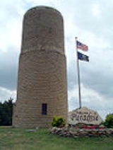
. Early settlers to the area discovered that while there was a shortage of timber, limestone was plentiful, and therefore it was commonly used as a building material. It was also commonly used for fence posts. The watertower and the former Kennedy Hotel were recently added to the National Register of Historic Places
and featured in an article in the Salina Journal.
Schools
Maps
Russell County, Kansas
Russell County is a county located in the U.S. state of Kansas. The county's population was 6,970 for the 2010 census...
, Kansas
Kansas
Kansas is a US state located in the Midwestern United States. It is named after the Kansas River which flows through it, which in turn was named after the Kansa Native American tribe, which inhabited the area. The tribe's name is often said to mean "people of the wind" or "people of the south...
, United States
United States
The United States of America is a federal constitutional republic comprising fifty states and a federal district...
. As of the 2010 census, the city population was 49.
History
In 1859, a hunting party explored the area, including a small tributary of the Saline RiverSaline River (Kansas)
The Saline River is a tributary of the Smoky Hill River in the central Great Plains of North America. The entire length of the river lies in the U.S. state of Kansas. The river takes its name from the French translation of its Native name Ne Miskua, referring to its salty content.-Geography:The...
which led them to a site abundant in water, timber, and bison
American Bison
The American bison , also commonly known as the American buffalo, is a North American species of bison that once roamed the grasslands of North America in massive herds...
. One of the hunters, James R. Mead, described the site as paradise
Paradise
Paradise is a place in which existence is positive, harmonious and timeless. It is conceptually a counter-image of the miseries of human civilization, and in paradise there is only peace, prosperity, and happiness. Paradise is a place of contentment, but it is not necessarily a land of luxury and...
, and the tributary subsequently became known as Paradise Creek. The first post office
Post office
A post office is a facility forming part of a postal system for the posting, receipt, sorting, handling, transmission or delivery of mail.Post offices offer mail-related services such as post office boxes, postage and packaging supplies...
in the area opened under the name Paradise in 1875. In 1887, the Union Townsite Company established a town on the north side of the creek northwest of the post office, naming it Ivamar after Iva Marr, the popular and beautiful daughter of a local rancher. The Paradise post office relocated to Ivamar the next year, but kept its name. As a result, the town came to be known by both names; in 1891, the Union Pacific Railroad
Union Pacific Railroad
The Union Pacific Railroad , headquartered in Omaha, Nebraska, is the largest railroad network in the United States. James R. Young is president, CEO and Chairman....
listed its rail stop there as Paradise with Ivamar in parentheses. The community grew through the 1890s to include a school, downtown businesses, and railroad facilities, reaching a population of 200 by 1910. Ivamar incorporated
Municipal corporation
A municipal corporation is the legal term for a local governing body, including cities, counties, towns, townships, charter townships, villages, and boroughs. Municipal incorporation occurs when such municipalities become self-governing entities under the laws of the state or province in which...
in 1924 and finally changed its name to Paradise. The population of the community has gradually declined since the 1930s.
Geography
Paradise is located at 39°6′56"N 98°55′3"W (39.115445, -98.917428) at an elevation of 1,693 feet (516 m). It lies in the Smoky HillsSmoky Hills
The Smoky Hills are an upland region of hills in the central Great Plains of North America. They are located in the central United States, encompassing north-central Kansas and a small portion of south-central Nebraska. The hills are a dissected plain covered by tallgrass and mixed-grass prairie...
region of the Great Plains
Great Plains
The Great Plains are a broad expanse of flat land, much of it covered in prairie, steppe and grassland, which lies west of the Mississippi River and east of the Rocky Mountains in the United States and Canada. This area covers parts of the U.S...
approximately 6 miles (9.7 km) north of the Saline River
Saline River (Kansas)
The Saline River is a tributary of the Smoky Hill River in the central Great Plains of North America. The entire length of the river lies in the U.S. state of Kansas. The river takes its name from the French translation of its Native name Ne Miskua, referring to its salty content.-Geography:The...
on the north side of Paradise Creek, a tributary of the Saline, immediately west of the creek's confluence with Eagle Creek, which runs south along the city's east side. Located in north-central Kansas 3.5 miles (5.6 km) west of U.S. Route 281
U.S. Route 281
U.S. Route 281 is a north–south United States highway. At 1,872 miles long it is the longest continuous three-digit U.S. Route....
on Kansas Highway 18 (K-18)
K-18 (Kansas highway)
K-18 is a primarily east–west state highway running between US-24 and I-70 in north central Kansas.-Route description:K-18 begins near the town of Bogue in Graham County as it branches off to the south from US-24...
, Paradise is approximately 127 miles (204.4 km) northwest of Wichita
Wichita, Kansas
Wichita is the largest city in the U.S. state of Kansas.As of the 2010 census, the city population was 382,368. Located in south-central Kansas on the Arkansas River, Wichita is the county seat of Sedgwick County and the principal city of the Wichita metropolitan area...
, 233 miles (375 km) west of Kansas City
Kansas City, Missouri
Kansas City, Missouri is the largest city in the U.S. state of Missouri and is the anchor city of the Kansas City Metropolitan Area, the second largest metropolitan area in Missouri. It encompasses in parts of Jackson, Clay, Cass, and Platte counties...
, and 15 miles (24.1 km) north-northwest of Russell
Russell, Kansas
Russell is the most populous city in and county seat of Russell County, Kansas, United States. As of the 2010 census, the city population was 4,506.-History:...
, the county seat
County seat
A county seat is an administrative center, or seat of government, for a county or civil parish. The term is primarily used in the United States....
.
According to the United States Census Bureau
United States Census Bureau
The United States Census Bureau is the government agency that is responsible for the United States Census. It also gathers other national demographic and economic data...
, the city has a total area of 0.2 square mile (0.517997622 km²), all of it land.
Demographics
As of the 2010 census, there were 49 people, 22 households, and 13 families residing in the city. The population densityPopulation density
Population density is a measurement of population per unit area or unit volume. It is frequently applied to living organisms, and particularly to humans...
was 163.3 people per square mile (63.1/km²). There were 27 housing units at an average density of 90.0 per square mile (38.6/km²). The racial makeup of the city was 100.0% White
White American
White Americans are people of the United States who are considered or consider themselves White. The United States Census Bureau defines White people as those "having origins in any of the original peoples of Europe, the Middle East, or North Africa...
. Hispanic or Latino of any race were 0.0% of the population.
There were 22 households out of which 27.3% had children under the age of 18 living with them, 54.5% were married couples
Marriage
Marriage is a social union or legal contract between people that creates kinship. It is an institution in which interpersonal relationships, usually intimate and sexual, are acknowledged in a variety of ways, depending on the culture or subculture in which it is found...
living together, 0.0% had a male householder with no wife present, 4.5% had a female householder with no husband present, and 40.9% were non-families. 36.4% of all households were made up of individuals, and 27.2% had someone living alone who was 65 years of age or older. The average household size was 2.23, and the average family size was 2.92.
In the city the population was spread out with 26.5% under the age of 18, 0.0% from 18 to 24, 20.4% from 25 to 44, 28.6% from 45 to 64, and 24.5% who were 65 years of age or older. The median age was 47.5 years. For every 100 females, there were 81.5 males. For every 100 females age 18 and over, there were 80 males age 18 and over.
As of 2009, the median income for a household in the city was $36,250, and the median income for a family was $46,250. Males had a median income of $19,688 versus $40,417 for females. The per capita income
Per capita income
Per capita income or income per person is a measure of mean income within an economic aggregate, such as a country or city. It is calculated by taking a measure of all sources of income in the aggregate and dividing it by the total population...
for the city was $17,643. There were 5.9% of families and 3.4% of the population living below the poverty line, including 5.3% of those under age 18 and none of those age 65 or over.
Government
Paradise is a city of the third class with a mayor-councilMayor-council government
The mayor–council government system, sometimes called the mayor–commission government system, is one of the two most common forms of local government for municipalities...
form of government. The city council
City council
A city council or town council is the legislative body that governs a city, town, municipality or local government area.-Australia & NZ:Because of the differences in legislation between the States, the exact definition of a City Council varies...
consists of five members, and it meets on the second Monday of each month.
Education
Paradise lies within Unified School District (USD)Unified school district
A unified school district or unit school district is a school district which includes both primary school and high school under the same district control....
399, based in nearby Natoma
Natoma, Kansas
Natoma is a city in Osborne County, Kansas, United States. As of the 2010 census, the city population was 335.-History:Natoma was established in 1888, named after an American Indian railroad employee by a railroad officer. The name means "new born." The first post office had opened under the name...
.
Transportation
K-18K-18 (Kansas highway)
K-18 is a primarily east–west state highway running between US-24 and I-70 in north central Kansas.-Route description:K-18 begins near the town of Bogue in Graham County as it branches off to the south from US-24...
, an east-west route, approaches Paradise from the northwest, then turns east north of the city. Paradise Road, a paved county road, enters the city from the south.
Architecture
Paradise is home to several unique structures that were constructed from Post Rock LimestoneLimestone
Limestone is a sedimentary rock composed largely of the minerals calcite and aragonite, which are different crystal forms of calcium carbonate . Many limestones are composed from skeletal fragments of marine organisms such as coral or foraminifera....
. Early settlers to the area discovered that while there was a shortage of timber, limestone was plentiful, and therefore it was commonly used as a building material. It was also commonly used for fence posts. The watertower and the former Kennedy Hotel were recently added to the National Register of Historic Places
National Register of Historic Places
The National Register of Historic Places is the United States government's official list of districts, sites, buildings, structures, and objects deemed worthy of preservation...
and featured in an article in the Salina Journal.
External links
CitySchools
- USD 399, local school district
Maps
- Paradise City Map, KDOT
- Russell County Map, KDOT