
Paleoseismology
Encyclopedia
Sediment
Sediment is naturally occurring material that is broken down by processes of weathering and erosion, and is subsequently transported by the action of fluids such as wind, water, or ice, and/or by the force of gravity acting on the particle itself....
s and rocks
Rock (geology)
In geology, rock or stone is a naturally occurring solid aggregate of minerals and/or mineraloids.The Earth's outer solid layer, the lithosphere, is made of rock. In general rocks are of three types, namely, igneous, sedimentary, and metamorphic...
, for signs of ancient earthquake
Earthquake
An earthquake is the result of a sudden release of energy in the Earth's crust that creates seismic waves. The seismicity, seismism or seismic activity of an area refers to the frequency, type and size of earthquakes experienced over a period of time...
s. It is used to supplement seismic monitoring
Seismology
Seismology is the scientific study of earthquakes and the propagation of elastic waves through the Earth or through other planet-like bodies. The field also includes studies of earthquake effects, such as tsunamis as well as diverse seismic sources such as volcanic, tectonic, oceanic,...
, for the calculation of seismic hazard
Seismic hazard
Seismic hazard refers to the study of expected earthquake ground motions at the earth's surface, and its likely effects on existing natural conditions and man-made structures for public safety considerations; the results of such studies are published as seismic hazard maps, which identify the...
. Paleoseismology is usually restricted to geologic regimes that have undergone continuous sediment creation for the last few thousand years, such as swamp
Swamp
A swamp is a wetland with some flooding of large areas of land by shallow bodies of water. A swamp generally has a large number of hammocks, or dry-land protrusions, covered by aquatic vegetation, or vegetation that tolerates periodical inundation. The two main types of swamp are "true" or swamp...
s, lake
Lake
A lake is a body of relatively still fresh or salt water of considerable size, localized in a basin, that is surrounded by land. Lakes are inland and not part of the ocean and therefore are distinct from lagoons, and are larger and deeper than ponds. Lakes can be contrasted with rivers or streams,...
s, river
River
A river is a natural watercourse, usually freshwater, flowing towards an ocean, a lake, a sea, or another river. In a few cases, a river simply flows into the ground or dries up completely before reaching another body of water. Small rivers may also be called by several other names, including...
beds and shorelines.
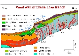
In this typical example, a trench is dug in an active sedimentation regime. Evidence of thrust fault
Thrust fault
A thrust fault is a type of fault, or break in the Earth's crust across which there has been relative movement, in which rocks of lower stratigraphic position are pushed up and over higher strata. They are often recognized because they place older rocks above younger...
ing can be seen in the walls of the trench. It becomes a matter of deducting the relative age of each fault, by cross-cutting patterns. The faults can be dated in absolute terms, if there is dateable carbon
Radiocarbon dating
Radiocarbon dating is a radiometric dating method that uses the naturally occurring radioisotope carbon-14 to estimate the age of carbon-bearing materials up to about 58,000 to 62,000 years. Raw, i.e. uncalibrated, radiocarbon ages are usually reported in radiocarbon years "Before Present" ,...
, or human artifacts.
Many notable discoveries have been made using the techniques of paleoseismology. For example, there is a common misconception that having many smaller earthquakes can somehow 'relieve' a major fault such as the San Andreas, and reduce the chance of a major earthquake . It is now known (using paleoseismology) that nearly all the movement of the fault takes place with extremely large earthquakes. All of these seismic events (with a Moment Magnitude
Moment magnitude scale
The moment magnitude scale is used by seismologists to measure the size of earthquakes in terms of the energy released. The magnitude is based on the seismic moment of the earthquake, which is equal to the rigidity of the Earth multiplied by the average amount of slip on the fault and the size of...
of over 8), leave some sort of trace in the sedimentation record.
Another famous example involves the Megathrust earthquake
Megathrust earthquake
Megathrust earthquakes occur at subduction zones at destructive plate boundaries , where one tectonic plate is forced under another. Due to the shallow dip of the plate boundary, which causes large sections to get stuck, these earthquakes are among the world's largest, with moment magnitudes ...
s of the Pacific Northwest. It was thought for some time that there was low seismic hazard in region because relatively few modern earthquakes are being recorded. There was a concept that the subduction zone was merely sliding in a benign manner.
All of these comforting notions were shattered by paleoseismology studies showing evidence of extremely large earthquakes , along with historical tsunami
Tsunami
A tsunami is a series of water waves caused by the displacement of a large volume of a body of water, typically an ocean or a large lake...
records. In effect, the subduction
Subduction
In geology, subduction is the process that takes place at convergent boundaries by which one tectonic plate moves under another tectonic plate, sinking into the Earth's mantle, as the plates converge. These 3D regions of mantle downwellings are known as "Subduction Zones"...
zone under British Columbia, Washington, Oregon, and far northern California, is perfectly normal, being extremely hazardous in the long term, with the capability of generating coastal tsunamis of several hundred feet in height at the coast. These are caused by the interface between the subducted sea floor stressing the overlaying coastal soils in compression. Periodically a slip will occur which causes the coastal portion to reduce in elevation and thrust toward the west, leading to tsunamis in the central and eastern north Pacific ocean (with several hours of warning) and a reflux of water toward the coastal shore, with little time for residents to escape.
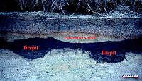
An educational excavation


General references
- James P. McCalpin (2009) Paleoseismology (2nd Edition), Academic Press, ISBN 0123735769, ISBN 978-0123735768
- James P. McCalpin (1996) Paleoseismology, Elsevier, ISBN 0124818269