
Padstow Heights, New South Wales
Encyclopedia
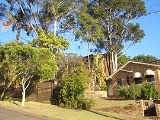
Padstow Heights, a suburb
of local government area City of Bankstown
, is located 23 kilometres south-west of the Sydney central business district
, in the state of New South Wales
, Australia
, and is a part of the South-western Sydney
region. Padstow
is a separate suburb to the north and One Tree Point is a locality within Padstow Heights.
Padstow Heights is a mostly residential suburb bounded on the east by Salt Pan Creek
and to the south by the Georges River
. The Alfords Point Bridge
links Padstow Heights to Alfords Point
in the Sutherland Shire
.
in Cornwall
, England
. It was named for being the "holy place of St Petrock" (not to be confused with St Patrick), an important Cornish saint.
- controversial former detective-sergeant of the New South Wales Police Force
Suburb
The word suburb mostly refers to a residential area, either existing as part of a city or as a separate residential community within commuting distance of a city . Some suburbs have a degree of administrative autonomy, and most have lower population density than inner city neighborhoods...
of local government area City of Bankstown
City of Bankstown
The City of Bankstown is a city and Local Government Area in the Canterbury-Bankstown region of Sydney, New South Wales, Australia, centred on the suburb of Bankstown....
, is located 23 kilometres south-west of the Sydney central business district
Sydney central business district
The Sydney central business district is the main commercial centre of Sydney, New South Wales, Australia. It extends southwards for about 3 kilometres from Sydney Cove, the point of first European settlement. Its north–south axis runs from Circular Quay in the north to Central railway station in...
, in the state of New South Wales
New South Wales
New South Wales is a state of :Australia, located in the east of the country. It is bordered by Queensland, Victoria and South Australia to the north, south and west respectively. To the east, the state is bordered by the Tasman Sea, which forms part of the Pacific Ocean. New South Wales...
, Australia
Australia
Australia , officially the Commonwealth of Australia, is a country in the Southern Hemisphere comprising the mainland of the Australian continent, the island of Tasmania, and numerous smaller islands in the Indian and Pacific Oceans. It is the world's sixth-largest country by total area...
, and is a part of the South-western Sydney
South-western Sydney
South-western Sydney is a general term which is used to describe the metropolitan area in south-west Sydney, New South Wales, Australia. It is part of the Greater Western Sydney area....
region. Padstow
Padstow, New South Wales
Padstow, a suburb of local government area City of Bankstown, is located 22 kilometres inner south-west of the Sydney central business district, in the state of New South Wales, Australia, and is a part of the South-western Sydney region....
is a separate suburb to the north and One Tree Point is a locality within Padstow Heights.
Padstow Heights is a mostly residential suburb bounded on the east by Salt Pan Creek
Salt Pan Creek
Salt Pan Creek is a small creek located in the Salt Pan Creek catchment area, in south-western Sydney, in the state of New South Wales, Australia. It is located between the suburbs of Padstow and Riverwood and feeds into the Georges River. The catchment area covers about 26km2, with 11.7km2 of this...
and to the south by the Georges River
Georges River
The Georges River is a waterway in the state of New South Wales in Australia. It rises to the south-west of Sydney near the coal mining town of Appin, and then flows north past Campbelltown, roughly parallel to the Main South Railway...
. The Alfords Point Bridge
Alfords Point Bridge, New South Wales
Alfords Point Bridge is one of three major road crossings of the lower Georges River. It was opened on the 7 September 1973. The bridge links Padstow Heights in the City of Bankstown to Alfords Point in the Sutherland Shire...
links Padstow Heights to Alfords Point
Alfords Point, New South Wales
Alfords Point is a suburb in southern Sydney, in the state of New South Wales, Australia. Alfords Point is located 28 kilometres south of the Sydney central business district, in the local government area of the Sutherland Shire in the area commonly called Menai...
in the Sutherland Shire
Sutherland Shire
The Sutherland Shire is a Local Government Area in the Southern Sydney region of Sydney, Australia. Geographically, it is the area to the south of Botany Bay and the Georges River...
.
History
The Padstow area was first named Padstow Park Estate after a town called PadstowPadstow
Padstow is a town, civil parish and fishing port on the north coast of Cornwall, England, United Kingdom. The town is situated on the west bank of the River Camel estuary approximately five miles northwest of Wadebridge, ten miles northwest of Bodmin and ten miles northeast of Newquay...
in Cornwall
Cornwall
Cornwall is a unitary authority and ceremonial county of England, within the United Kingdom. It is bordered to the north and west by the Celtic Sea, to the south by the English Channel, and to the east by the county of Devon, over the River Tamar. Cornwall has a population of , and covers an area of...
, England
England
England is a country that is part of the United Kingdom. It shares land borders with Scotland to the north and Wales to the west; the Irish Sea is to the north west, the Celtic Sea to the south west, with the North Sea to the east and the English Channel to the south separating it from continental...
. It was named for being the "holy place of St Petrock" (not to be confused with St Patrick), an important Cornish saint.
Notable residents
Roger RogersonRoger Rogerson
Roger Caleb Rogerson is a controversial former detective-sergeant of the New South Wales Police Force. Rogerson was convicted of perverting the course of justice and lying to the 1999 Police Integrity Commission...
- controversial former detective-sergeant of the New South Wales Police Force