
Alfords Point, New South Wales
Encyclopedia
Alfords Point is a suburb
in southern
Sydney
, in the state of New South Wales
, Australia
. Alfords Point is located 28 kilometres south of the Sydney central business district
, in the local government area of the Sutherland Shire
in the area commonly called Menai. Alfords Point shares the postcode of 2234 with neighbouring suburbs of Menai
, Bangor
and Illawong
.
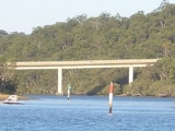
Alfords Point is located on the southern bank of the Georges River
.The suburb is nearly completely surrounded by bushland from the Georges River nature Reserve and with Alfords point Road within its Eastern side border running south to north onto the Alfords Point Road Bridge across the Georges River towards Padstow, There is only one road to enter and exit the Alfords Point which is called Brushwood Drive.
.
When the Sutherland Shire was officially formed in 1906, the western boundary extended to what is today called Menai
(then called Bangor). In 1922, a proclamation was made to allow for an adjustment of the shire boundaries and include a the areas which are now Illawong
and Alfords Point. The area was formerly attached to the Municipality of Hurstville. Modern Alfords Point began to develop alongside the Menai Town Centre initiative in the late 1970s-1980s with large plots of bushland divided for housing development.
Alfords Point residents have been victim to bushfires, perhaps the most infamous being those of the 1994 Eastern seaboard fires
which claimed many homes in the area, particularly those directly neighbouring the Georges River National Park. Other recent bushfires in the area occurred in Summer 1997/98 and Summer 2001/2002, however, damage to property was limited due to improved bush prevention as a result of the 1993/94 disaster.
in local competitions. Narina Park also hosts the Alfords Point Community Centre, which can be hired out from Sutherland Shire Council. Natural bushland is abundant in this area, as Alfords Point is positioned on the shores of the Georges River and National Park, with many walking tracks and firetrails popular amongst locals in summer.
Suburb
The word suburb mostly refers to a residential area, either existing as part of a city or as a separate residential community within commuting distance of a city . Some suburbs have a degree of administrative autonomy, and most have lower population density than inner city neighborhoods...
in southern
Southern Sydney
This article refers to an area the same as a combination of St George and SutherlandSouthern Sydney is a general term which is used to describe the southern metropolitan area of Sydney, in the state of New South Wales, Australia....
Sydney
Sydney
Sydney is the most populous city in Australia and the state capital of New South Wales. Sydney is located on Australia's south-east coast of the Tasman Sea. As of June 2010, the greater metropolitan area had an approximate population of 4.6 million people...
, in the state of New South Wales
New South Wales
New South Wales is a state of :Australia, located in the east of the country. It is bordered by Queensland, Victoria and South Australia to the north, south and west respectively. To the east, the state is bordered by the Tasman Sea, which forms part of the Pacific Ocean. New South Wales...
, Australia
Australia
Australia , officially the Commonwealth of Australia, is a country in the Southern Hemisphere comprising the mainland of the Australian continent, the island of Tasmania, and numerous smaller islands in the Indian and Pacific Oceans. It is the world's sixth-largest country by total area...
. Alfords Point is located 28 kilometres south of the Sydney central business district
Sydney central business district
The Sydney central business district is the main commercial centre of Sydney, New South Wales, Australia. It extends southwards for about 3 kilometres from Sydney Cove, the point of first European settlement. Its north–south axis runs from Circular Quay in the north to Central railway station in...
, in the local government area of the Sutherland Shire
Sutherland Shire
The Sutherland Shire is a Local Government Area in the Southern Sydney region of Sydney, Australia. Geographically, it is the area to the south of Botany Bay and the Georges River...
in the area commonly called Menai. Alfords Point shares the postcode of 2234 with neighbouring suburbs of Menai
Menai, New South Wales
Menai is a suburb in southern Sydney, in the state of New South Wales, Australia. Menai is located 29 kilometres south of the Sydney central business district in the local government area of the Sutherland Shire.-History:...
, Bangor
Bangor, New South Wales
Bangor is a suburb in southern Sydney, in the state of New South Wales, Australia. Bangor is located 28 kilometres south of the Sydney central business district, in the local government area of the Sutherland Shire in the area commonly called Menai...
and Illawong
Illawong, New South Wales
Illawong is a suburb in southern Sydney, in the state of New South Wales, Australia. Illawong is located 27 kilometres south-west of the Sydney Central Business District, in the local government area of the Sutherland Shire in the area commonly called Menai...
.
Alfords Point is located on the southern bank of the Georges River
Georges River
The Georges River is a waterway in the state of New South Wales in Australia. It rises to the south-west of Sydney near the coal mining town of Appin, and then flows north past Campbelltown, roughly parallel to the Main South Railway...
.The suburb is nearly completely surrounded by bushland from the Georges River nature Reserve and with Alfords point Road within its Eastern side border running south to north onto the Alfords Point Road Bridge across the Georges River towards Padstow, There is only one road to enter and exit the Alfords Point which is called Brushwood Drive.
History
Jane Alford, widow of John Alford Senior owned 50 acres (202,343 m²) of land near here in 1828. Alford was originally the name given to an area of public reserve on the bank of the Georges RiverGeorges River
The Georges River is a waterway in the state of New South Wales in Australia. It rises to the south-west of Sydney near the coal mining town of Appin, and then flows north past Campbelltown, roughly parallel to the Main South Railway...
.
When the Sutherland Shire was officially formed in 1906, the western boundary extended to what is today called Menai
Menai, New South Wales
Menai is a suburb in southern Sydney, in the state of New South Wales, Australia. Menai is located 29 kilometres south of the Sydney central business district in the local government area of the Sutherland Shire.-History:...
(then called Bangor). In 1922, a proclamation was made to allow for an adjustment of the shire boundaries and include a the areas which are now Illawong
Illawong, New South Wales
Illawong is a suburb in southern Sydney, in the state of New South Wales, Australia. Illawong is located 27 kilometres south-west of the Sydney Central Business District, in the local government area of the Sutherland Shire in the area commonly called Menai...
and Alfords Point. The area was formerly attached to the Municipality of Hurstville. Modern Alfords Point began to develop alongside the Menai Town Centre initiative in the late 1970s-1980s with large plots of bushland divided for housing development.
Alfords Point residents have been victim to bushfires, perhaps the most infamous being those of the 1994 Eastern seaboard fires
1994 Eastern seaboard fires
The 1994 Eastern seaboard fires were bushfires in New South Wales, Australia between 27 December 1993 and 16 January 1994 were widespread along the NSW coast from Bega to the Queensland border and inland as far as Bathurst. Over 80 separate fires encouraged by extreme hot dry and windy conditions...
which claimed many homes in the area, particularly those directly neighbouring the Georges River National Park. Other recent bushfires in the area occurred in Summer 1997/98 and Summer 2001/2002, however, damage to property was limited due to improved bush prevention as a result of the 1993/94 disaster.
Commercial area
Alfords Point has a small group of shops on Brushwood Drive adjacent to Alfords Point Public School. Shops include a hair salon, pharmacy, convenience store, Charcoal Chicken & Pizza take-away and the Menai Dance Centre.Sport and recreation
Alfords Point contains two sporting ovals, one named Casuarina Road Oval positioned on Casuarina Road and the other named Narina Park positioned on Coachwood Crescent, which are used for soccer and cricketCricket
Cricket is a bat-and-ball game played between two teams of 11 players on an oval-shaped field, at the centre of which is a rectangular 22-yard long pitch. One team bats, trying to score as many runs as possible while the other team bowls and fields, trying to dismiss the batsmen and thus limit the...
in local competitions. Narina Park also hosts the Alfords Point Community Centre, which can be hired out from Sutherland Shire Council. Natural bushland is abundant in this area, as Alfords Point is positioned on the shores of the Georges River and National Park, with many walking tracks and firetrails popular amongst locals in summer.